
Search for another town


Free U.S. delivery 7 to 10 days after you order
Alamogordo, New Mexico Map Art
Building by building, with labeled streets and shaded relief.
12" x 18" Archival Matte Print
A Map of Home. A Work of Art.
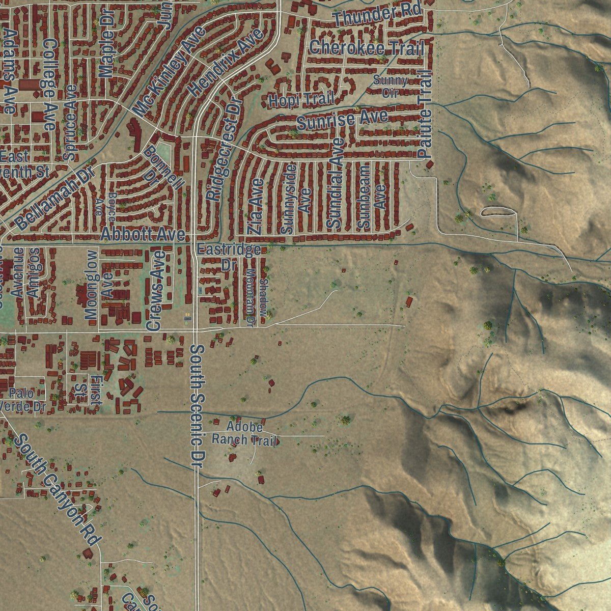
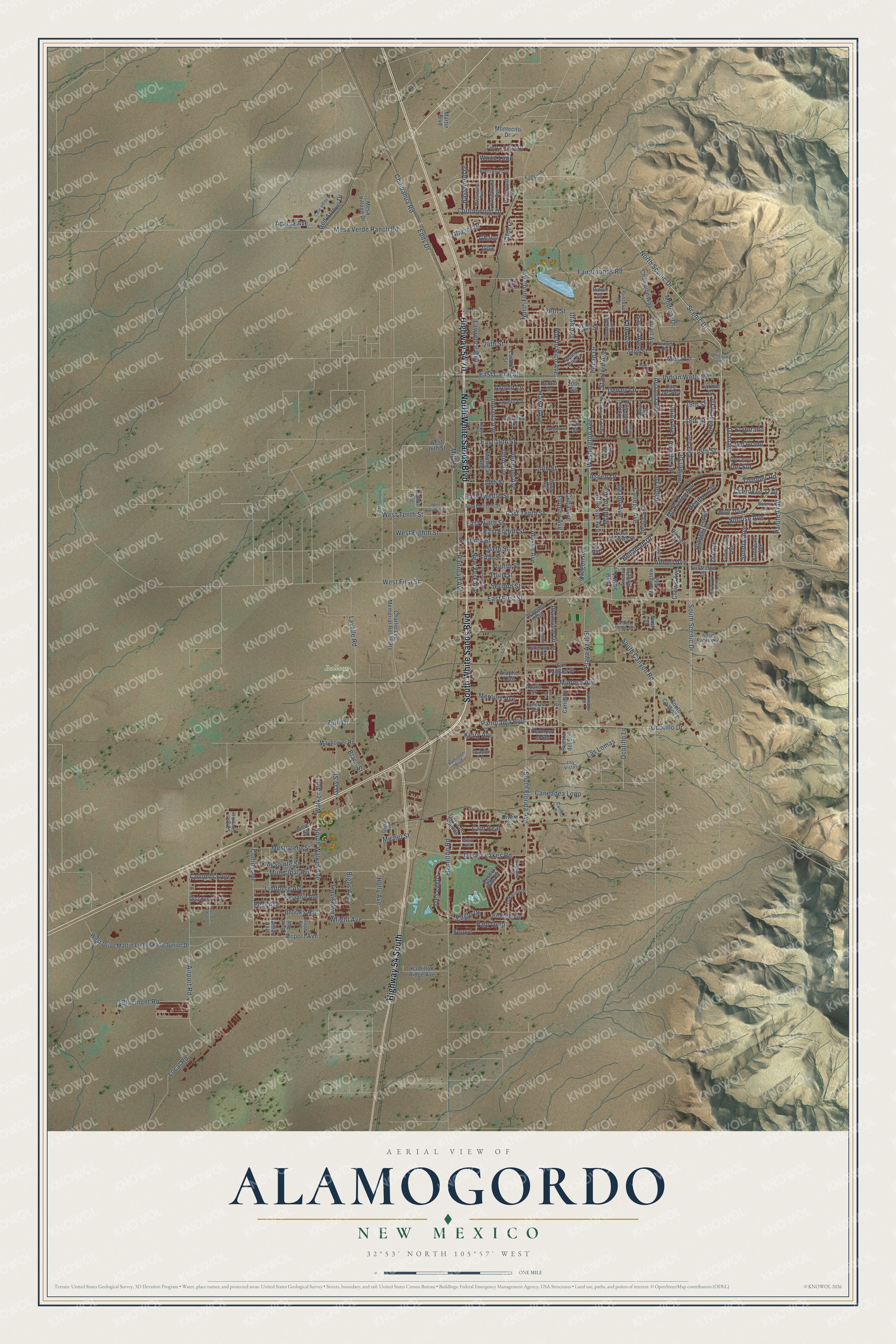
Explore Alamogordo, New Mexico from a whole new perspective. Created using aerial imagery and detailed geographic data, this map captures Alamogordo building by building, with labeled streets, familiar landmarks, and shaded topographical relief that highlights the natural contours of the landscape.
Combining modern data with the timeless character of a vintage atlas, this map is just as interesting up close as it is beautiful on the wall. Whether you grew up in Alamogordo, spent memorable years there, or call it home today, this unique map is a great way to celebrate a place that means something to you. Zoom in on the preview to look for your street, and then order a print to put your memories on the wall.
Three ways to hang it

Unframed archival matte, a black wood frame or a white wood frame.
Up close
Geography Worth Displaying
This map was created using accurate cartographic data and authoritative geographic sources, including the U.S. Geological Survey and the Census Bureau. The map brings together terrain, waterways, roads, and building detail. The majority of the streets are labeled, houses are accurately depicted, and the topography is derived from government sources. Combining local data with carefully composed color and shading leads to this beautifully detailed Alamogordo artwork for your wall.
Rather than simply showing street outlines, we’ve included as many of the street names as we could reasonably fit on the map while keeping their names legible. Zoom in on the high resolution preview to see exactly what’s on the map. We truly set out to create a statement piece for anyone who loves Alamogordo. So whether it’s for you, or a gift for someone you love, we hope this map of Alamogordo brings back fond memories.
Read the story behind this map of Alamogordo, New Mexico from 2026.

Find your street
Names on the Alamogordo map
Every name below is printed on this map. Look for your street, your school, the park where you played, or the pond down the road.
Places and landmarks1
- Balloon Park
Streets and roads240
- North White Sands Boulevard
- South White Sands Boulevard
- Highway 54 70
- Highway 54 South
- North Scenic Drive
- Scenic Drive
- South Florida Avenue
- South Scenic Drive
- Ocotillo Drive
- West First Street
- Walker Avenue
- East First Street
- Mill Road
- Del Sur
- East Tenth Street
- Eddy Drive
- Airport Road
- South Canyon Road
- Jefferson Avenue
- Wood Loop
- Paiute Trail
- Dewey Lane
- South Walker Avenue
- Municipal Avenue
- Mc Kinley Avenue
- West Tenth Street
- North Florida Avenue
- Hamilton Road
- Indian Wells Road
- Oregon Avenue
Show all 240 streets
- Washington Avenue
- Cuba Avenue
- Puerto Rico Avenue
- 15th Street
- Fairgrounds Road
- Alaska Avenue
- Hawaii Avenue
- 18th Street
- East Twelfth Street
- 24th Street
- East Eighth Street
- East Ninth Street
- Mesa Verde Ranch Road
- Lavelle Road
- Juniper Drive
- College Avenue
- New York Avenue
- Lindberg Avenue
- Post Avenue
- Wright Avenue
- Abbott Avenue
- East 16th Street
- 25th Street
- Seventh Street
- Caneadea Loop
- Indiana Avenue
- Bellamah Drive
- Sunrise Avenue
- 14th Street
- Airport Avenue
- 13th Street
- Desert Lakes Road
- Crescent Drive
- Collins Avenue
- Eagle Drive
- Fourth Street
- Pecan Drive
- Aspen Drive
- Chihuahua Road
- 23rd Street
- Arizona Avenue
- Las Lomas
- Railroad Avenue
- Madison Avenue
- Playa Azul Street
- Stanford Avenue
- Ridgecrest Drive
- Kerry Avenue
- Utah Avenue
- Brooks Avenue
- Bluemont Road
- Fifth Street
- Third Street
- Second Street
- Mimosa Avenue
- 19th Street
- Vermont Avenue
- Filipino Avenue
- Cottonwood Drive
- Adams Avenue
- Panorama Boulevard
- East Canal Street
- Local Road
- Tres Lagos
- Mesquite Street
- Mescalero Street
- Ohio Avenue
- Lawrence Boulevard
- 26th Street
- West Eighth Street
- Mesa Lane
- Sixth Street
- Hendrix Avenue
- Union Avenue
- Red Arroyo Drive
- Palo Duro
- Apache Lane
- Mercury Avenue
- Thunder Road
- Medical Drive
- Glacier Drive
- Basswood Drive
- Gray Street
- Granada
- Holly Avenue
- Biggs Avenue
- Travis Avenue
- Acacia Avenue
- Columbia Avenue
- Cherokee Trail
- Sundial Avenue
- Yale Avenue
- Cam Real
- Plainview Drive
- Del Prado
- Crews Avenue
- Baylor Avenue
- Maple Drive
- Zuni Drive
- Michel Street
- El Dorado
- Black Street
- Ocotillo Lane
- Arnold Lane
- Zia Avenue
- Chaco
- Gila
- James Street
- West 16th Street
- Tierra Bella Drive
- Ironwood Drive
- Puesta del Sol
- Charlie Lee Memorial Relief Route
- Catalina Lane
- West Drive Martin Luther King Junior Drive
- Lovers Lane
- Spruce Avenue
- Iowa Avenue
- Mesa Village Drive
- Michigan Avenue
- Bonnell Drive
- San Miguel Street
- Park Avenue
- Paradise Avenue
- Byrd Avenue
- Earhart Avenue
- Champion Way
- Cornell Avenue
- South Canyon Place
- Bosque
- Birdie Loop
- San Carlos Street
- Hermoso el Sol
- Rosewood Avenue
- Tierra de Suenos
- Hopi Trail
- Hamilton Ridge Avenue
- First Street
- Arapho Trail
- Desert Hills Drive
- Discovery Avenue
- Arapaho Trail
- Dale Scott Avenue
- Fayne Lane
- Corte del Sol
- Mayflower Road
- Lamar Circle
- East Seventh Street
- Van Court
- Carmel Drive
- Avenue Amigos
- Moonglow Avenue
- Desert Eve Drive
- Sherwood Drive
- Eudora Street
- Montecito Drive
- Sunnyside Avenue
- Divers Cv
- Sunbeam Avenue
- Martin Boulevard
- Eastridge Drive
- Dexter Lane
- Cam del Rey
- Azalia Street
- Pinon Drive
- Dublin Lane
- Cotton Avenue
- Taft Avenue
- 20th Street
- 17th Street
- Cielo Vis
- Hamilton Boulevard
- Santiago Street
- East Eleventh Street
- Stapp Avenue
- Princeton Avenue
- Amber Skies Avenue
- Oakmont Drive
- Adobe Ranch Trail
- Nevada Drive
- Mosswood Avenue
- Hubbard Drive
- Brentwood Drive
- Saguaro Loop
- Del Cerro
- Cambridge Avenue
- Cameo Drive
- Palo Verde Drive
- Constant Drive
- Unicorn Lane
- Aero Loop
- Teresa Lane
- Sunny Circle
- Otero Avenue
- Lincoln Avenue
- Las Vistas
- West Eleventh Street
- Delaware Avenue
- McDonald Road
- Greenwood Lane
- Corte Alegre
- Calle Verde Drive
- Coranado Drive
- Boyce Avenue
- Shadow Mountain Drive
- Rose Avenue
- Endeavor Avenue
- Hickory Drive
- 27th Street
- A-095
Names are listed as they appear on the printed map. Zoom into the product photos to find them.
About Alamogordo, New Mexico
Alamogordo is a city of 30,898 people and the county seat of Otero County. It sits in the Tularosa Basin at the foot of the Sacramento Mountains. The town was founded in June 1898, when Charles Bishop Eddy's El Paso and Northeastern Railroad reached the site. Eddy and his partners wanted a town that would last after the tracks were done. So they formed the Alamogordo Improvement Company. It owned every lot, laid out the streets and put up the first homes and shops. It also gave land for a college and wrote a ban on making or selling liquor into each deed.
Cutting timber for railroad ties was the first big business. Alamogordo became a city in 1912, and tourism grew after White Sands National Monument was created in 1934. The federal government arrived in force during World War II. The city is still widely linked to the Trinity test of 1945, the first atomic bomb ever set off.
“The railroad shops were among the first buildings to be completed at Alamogordo, but there is now (1906) a prospect of their removal. The town site is an arid plain, but was surveyed by the railroad engineers into fine, wide streets, and a great number of the rapidly growing cottonwoods planted everywhere.”
- Named for fat cottonwoodsJohn Arthur Eddy, brother of Charles, named the town. He made up the name from Spanish words for large or fat cottonwood. He was thinking of a grove of stout cottonwoods he remembered along the Pecos River, though the word was never really used in Spanish. In the 1898 plan, east and west streets got numbers and north and south streets got state names. Today's White Sands Boulevard began as Pennsylvania Avenue.
- Peter Hurd's post office frescoesThe Works Progress Administration built Alamogordo's main post office in the Pueblo style in 1938. Peter Hurd finished frescoes for its front porch in 1942. The post office moved out in 1961, and federal agencies used the building until the Forest Service left in October 2008. In February 2009 Otero County took it over and moved many county offices there. It joined the National Register in 2000.
- Holloman next doorThe Alamogordo Bombing and Gunnery Range opened in July 1941, and work on Alamogordo Army Airfield began in 1942. That field is now Holloman Air Force Base, about 3 miles west of the city. It is the biggest employer of city residents. German Air Force pilots trained there for 27 years. They moved to Sheppard Air Force Base in Texas in 2019.
- E.T. in the landfillIn 1983 Atari, Inc. dumped more than 700,000 unsold Atari 2600 cartridges in the city landfill. Many were copies of the flop E.T. the Extra-Terrestrial. For years people called the story an urban legend. Then Atari confirmed it, and digging at the landfill proved it true.
- A school town since 1903The state's school for blind and visually impaired students was founded in Alamogordo in 1903. New Mexico State University opened a branch campus in the city in 1958.
Keep exploring New Mexico
Alamogordo is one of 544 New Mexico towns we've mapped. Every dot on the map is a print of its own.
The search covers every state, New Mexico first.
Near Alamogordo
Order 2 or more town maps and save 10%. Shown in the size and finish you picked above, so they hang as a set.
- Boles Acres 12" x 18" / Archival Matte Print $39.99
- La Luz 12" x 18" / Archival Matte Print $39.99
- Holloman AFB 12" x 18" / Archival Matte Print $39.99


More maps nearby: High Rolls, Tularosa, Cloudcroft, Bent and Twin Forks.
The art of mapping a place
How This Map Was Made
Real places. Remarkable detail. Discover the layers that turn geographic data into a map of home.

The view from above
Aerial imagery reveals the character of the land: woodland, open fields, and the patterns of a place.

The shape of the land
Elevation data brings hills, valleys, and subtle changes in the landscape into view.

The details of home
Roads, waterways, and building footprints come together to make the map feel unmistakably local.

Geography becomes art
Considered color, shading, and typography bring the layers together in a map made for your wall.


Process illustrated with Mendon, Massachusetts. Aerial imagery: USDA NAIP. Terrain: USGS 3D Elevation Program. Map details and finished artwork: KNOWOL.
The Details
About This Print
Choose an archival matte print, or a black or white Ayous wood frame. The archival matte print is unframed.
Select your size and finish above to see the matching product image and price.
Materials & Craftsmanship
A contemporary map with the character of a classic atlas, printed on archival matte paper. Optional frames are made from Ayous wood.
Your printed map does not include the watermark shown in the full-map preview.
Shipping & Delivery
Free shipping within the United States. Every print is made to order in the USA.
Buying a gift? Add a note in your cart and we'll include it. We never put prices in the package.
Prints ship within 2 to 3 business days. Allow 7 to 10 days total from ordering for delivery. Timing may vary during holidays or periods of high order volume.
Read our shipping policy.
Returns and damaged prints
Each print is made to order. Change-of-mind refunds are not available after production.
If your print arrives damaged, misprinted or incorrect, contact support@knowol.com within 30 days of receiving it. Include your order number, photos and a description of the issue.
Read our full refund and replacement policy. For questions about your order, email support@knowol.com.