


Search for another town


Free U.S. delivery 7 to 10 days after you order
Auburn, California Map Art
Building by building, with labeled streets and shaded relief.
12" x 18" Archival Matte Print
A Map of Home. A Work of Art.
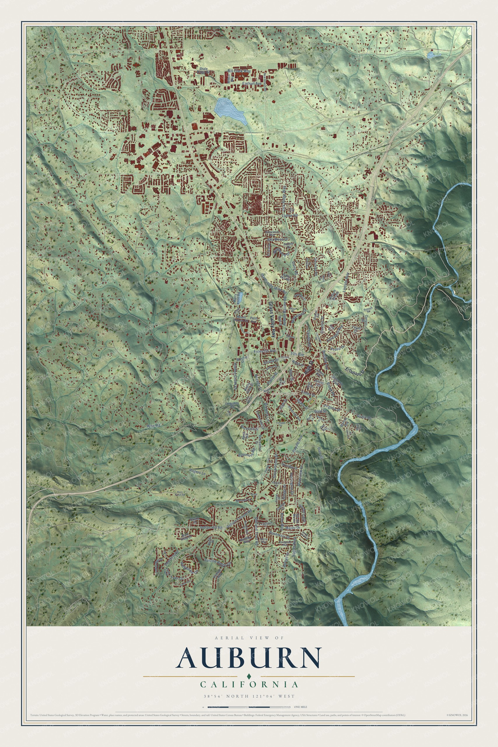
Explore Auburn, California from a whole new perspective. Created using aerial imagery and detailed geographic data, this map captures Auburn building by building, with labeled streets, familiar landmarks, and shaded topographical relief that highlights the natural contours of the landscape.
Combining modern data with the timeless character of a vintage atlas, this map is just as interesting up close as it is beautiful on the wall. Whether you grew up in Auburn, spent memorable years there, or call it home today, this unique map is a great way to celebrate a place that means something to you. Zoom in on the preview to look for your street, and then order a print to put your memories on the wall.
Three ways to hang it

Unframed archival matte, a black wood frame or a white wood frame.
Up close
Geography Worth Displaying
This map was created using accurate cartographic data and authoritative geographic sources, including the U.S. Geological Survey and the Census Bureau. The map brings together terrain, waterways, roads, and building detail. The majority of the streets are labeled, houses are accurately depicted, and the topography is derived from government sources. Combining local data with carefully composed color and shading leads to this beautifully detailed Auburn artwork for your wall.
Rather than simply showing street outlines, we’ve included as many of the street names as we could reasonably fit on the map while keeping their names legible. Zoom in on the high resolution preview to see exactly what’s on the map. We truly set out to create a statement piece for anyone who loves Auburn. So whether it’s for you, or a gift for someone you love, we hope this map of Auburn brings back fond memories.
Read the story behind this map of Auburn, California from 2026.

Find your street
Names on the Auburn map
Every name below is printed on this map. Look for your street, your school, the park where you played, or the pond down the road.
Places and landmarks2
- Auburn City Hall
- Gossonia Park
Streets and roads132
- Grass Valley Highway
- High Street
- Lincoln Way
- Elm Avenue
- Fulweiler Avenue
- Luther Road
- Hidden Creek Drive
- Brook Road
- Auburn Folsom Road
- Nevada Street
- Sacramento Street
- Borland Avenue
- Maidu Drive
- Virginia Street
- Chana Drive
- Auburn Ravine Road
- Sunrise Ridge Circle
- Dairy Road
- Aeolia Drive
- Foresthill Avenue
- Eagles Nest
- Riverview Drive
- Landis Circle
- Ridgeview Circle
- Pacific Avenue
- Arroyo Drive
- Mikkelsen Drive
- Dale Drive
- Indian Hill Road
- Gold Street
Show all 132 streets
- Rogers Lane
- Herrington Drive
- Robie Drive
- Alta Mesa Drive
- Finley Street
- Shirland Tract Road
- Rosemary Drive
- Ginger Drive
- Marguerite Mine Road
- Earhart Avenue
- Burlin Way
- Baltimore Road
- Electric Street
- Placer Street
- Oak Ridge Way
- Westwood Drive
- Deerbrooke
- Wise Road
- Vis del Lago
- Bill Clark Way
- Brewery Lane
- Agard Street
- Tyler Drive
- Pine Street
- El Dorado Street
- Blocker Drive
- Buena Vista Street
- Racetrack Street
- Cherry Avenue
- Vintage Way
- Pleasant Avenue
- Humbug Way
- Auburn Woods
- Palm Avenue
- Incline Drive
- Timberline Lane
- Sawka Drive
- Gum Lane
- Mont Vista Drive
- Skyridge Drive
- Holly Hill Road
- Mount Vernon Road
- Lakeridge Drive
- Linden Avenue
- Recreation Drive
- El Oro Drive
- Norman Lane
- Camjen Lane
- Shockley Road
- Toyon Drive
- Forgotten Road
- Vis del Monte
- Merry Knoll Road
- Shale Ridge Road
- Walsh Street
- Canyon Drive
- Olive Street
- Oak Street
- Marina Avenue
- Wall Street
- Awali Avenue
- Del Rey
- Wilbur Way
- Bluffs Place
- East Street
- Maple Street
- Gavin Circle
- Stephen Avenue
- Live Oak Street
- Carolyn Street
- Southridge Drive
- Sawyer Street
- Homestead Way
- New Airport Road
- Russell Road
- Swenson Court
- Stone Way
- Highland Drive
- Peregrine Way
- Fawn Creek
- Sutton Place
- Grove Court
- Forest Court
- Epperle Lane
- Teal Court
- Vidal Lane
- Snowy Owl Way
- Enterprise Drive
- Orrin Drive
- Perry Ranch Road
- Belmont Drive
- Tanglewood Drive
- Marion Way
- Baltic Circle
- Rio Camino Street
- Herdal Drive
- Welty Lane
- Teamtrack Road
- Lupine Lane
- Garfield Street
- Church Road
- Fairgate Road
Names are listed as they appear on the printed map. Zoom into the product photos to find them.
About Auburn, California
Auburn is a city of 13,776 people in Placer County, in the Sierra Nevada foothills high above the meeting of the North and Middle Forks of the American River. In the spring of 1848, a party of French miners heading for Coloma made camp in the ravine here, and on May 16 the young Claude Chana found gold. He and his companions, Francois Gendron and Philibert Courteau, stayed on to keep digging.
The camp was first called the North Fork Dry Diggings, and in 1849 miners from Auburn, New York, gave it its present name. That summer miners set up tents along the gold-rich ravines and worked them with pans, knives, spoons and rockers. Cabins went up wherever their builders pleased, and the paths that pack trains and wagons later wore between them became the town's crooked streets. By 1850 about 1,500 people lived here, and the following year, 1851, the town became the county seat of Placer County.
- A trading post with SutterWm. Gwynn and H. M. House opened Auburn's first stores about mid-July 1849, and Julius Wetzler soon started a trading post with Capt. John A. Sutter as Wetzler & Co. A store in the mines was saloon, eating house, gambling hall and lodging house at once. That winter, settlers from Otsego County, New York, having sailed around Cape Horn, sold goods from their cabins, and Auburn stayed a trading center after the miners left in spring.
- Rebuilt after every fireThe first town was made of tents, cloth houses and log cabins with canvas roofs, and frame buildings with clapboards, paint and plank floors appeared in the summer of 1850. Fire swept the streets several times and wiped out buildings and hard-won fortunes. Auburn took "Resurgam" as its motto, and the county history says a handsomer village rose after each fire.
- The railroad arrives in 1865Building east from Sacramento toward Ogden, Utah, the Central Pacific Railroad came through Auburn in 1865. It was the western half of the first transcontinental railroad. Its depot stood 1,360 feet above tide water, thirty-six miles northeast of Sacramento. Today one of the town's giant sculptures shows a Chinese laborer building that railroad, and another shows Claude Chana panning for gold.
- Sacagawea's son kept a hotelJean-Baptiste Charbonneau, the explorer son of Sacagawea, ran the Orleans Hotel in Auburn from 1860 to 1866.
Keep exploring California
Auburn is one of 1,990 California towns we've mapped. Every dot on the map is a print of its own.
The search covers every state, California first.
Near Auburn
Order 2 or more town maps and save 10%. Shown in the size and finish you picked above, so they hang as a set.
- North Auburn 12" x 18" / Archival Matte Print $39.99
- Ophir 12" x 18" / Archival Matte Print $39.99
- Newcastle 12" x 18" / Archival Matte Print $39.99


More maps nearby: Bowman, Auburn Lake Trails, Penryn, Meadow Vista and Loomis.
The art of mapping a place
How This Map Was Made
Real places. Remarkable detail. Discover the layers that turn geographic data into a map of home.

The view from above
Aerial imagery reveals the character of the land: woodland, open fields, and the patterns of a place.

The shape of the land
Elevation data brings hills, valleys, and subtle changes in the landscape into view.

The details of home
Roads, waterways, and building footprints come together to make the map feel unmistakably local.

Geography becomes art
Considered color, shading, and typography bring the layers together in a map made for your wall.


Process illustrated with Mendon, Massachusetts. Aerial imagery: USDA NAIP. Terrain: USGS 3D Elevation Program. Map details and finished artwork: KNOWOL.
The Details
About This Print
Choose an archival matte print, or a black or white Ayous wood frame. The archival matte print is unframed.
Select your size and finish above to see the matching product image and price.
Materials & Craftsmanship
A contemporary map with the character of a classic atlas, printed on archival matte paper. Optional frames are made from Ayous wood.
Your printed map does not include the watermark shown in the full-map preview.
Shipping & Delivery
Free shipping within the United States. Every print is made to order in the USA.
Buying a gift? Add a note in your cart and we'll include it. We never put prices in the package.
Prints ship within 2 to 3 business days. Allow 7 to 10 days total from ordering for delivery. Timing may vary during holidays or periods of high order volume.
Read our shipping policy.
Returns and damaged prints
Each print is made to order. Change-of-mind refunds are not available after production.
If your print arrives damaged, misprinted or incorrect, contact support@knowol.com within 30 days of receiving it. Include your order number, photos and a description of the issue.
Read our full refund and replacement policy. For questions about your order, email support@knowol.com.