


Search for another town


Free U.S. delivery 7 to 10 days after you order
Bethesda, Maryland Map Art
Building by building, with labeled streets and shaded relief.
12" x 18" Archival Matte Print
A Map of Home. A Work of Art.
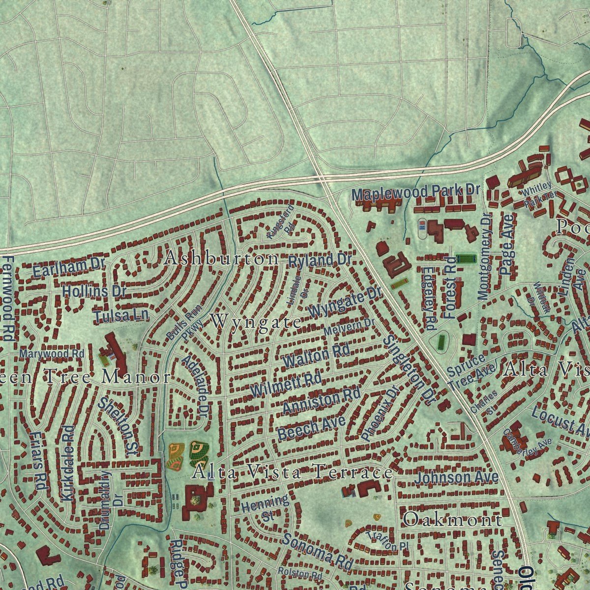
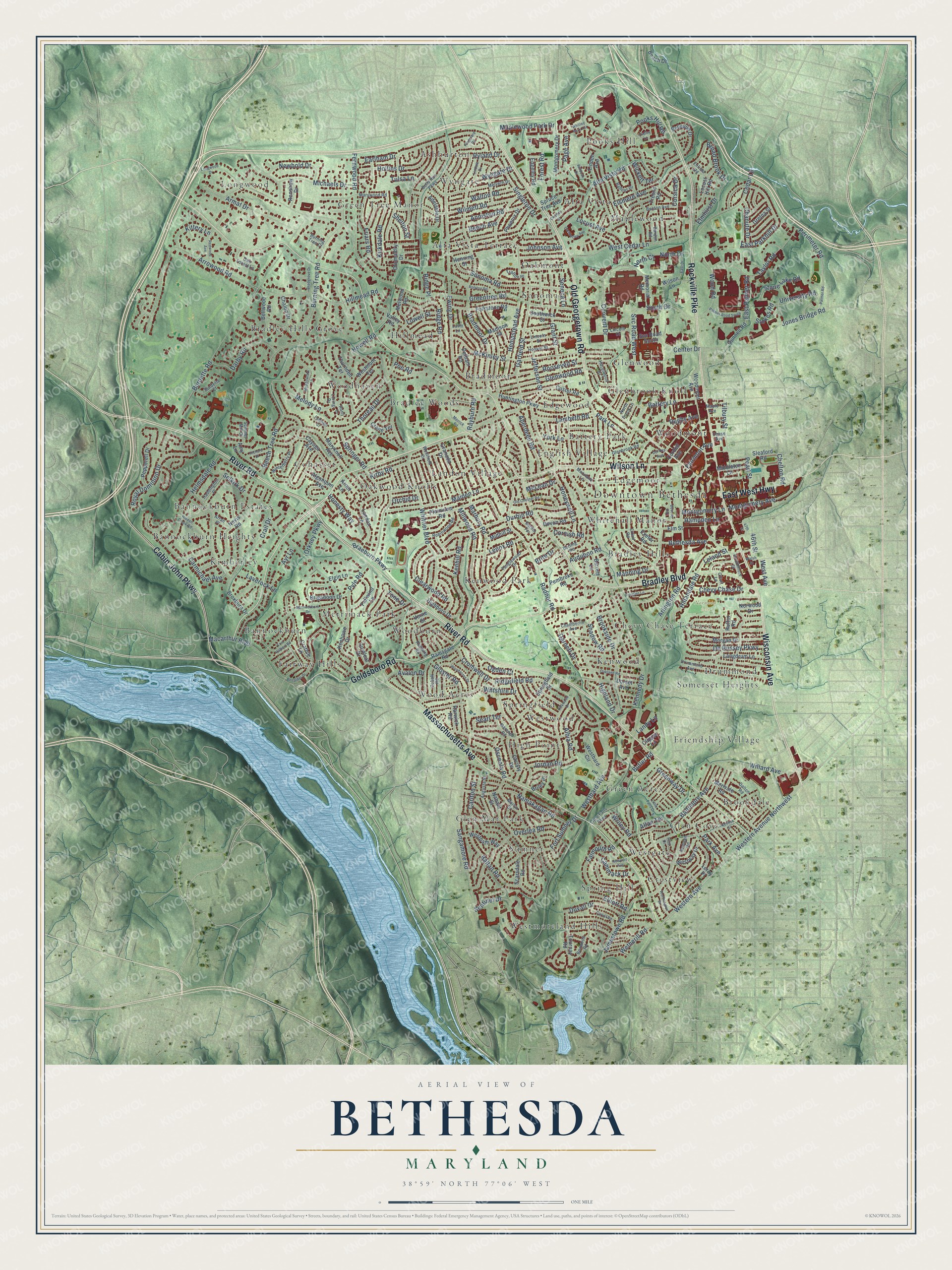
Explore Bethesda, Maryland from a whole new perspective. Created using aerial imagery and detailed geographic data, this map captures Bethesda building by building, with labeled streets, familiar landmarks, and shaded topographical relief that highlights the natural contours of the landscape.
Combining modern data with the timeless character of a vintage atlas, this map is just as interesting up close as it is beautiful on the wall. Whether you grew up in Bethesda, spent memorable years there, or call it home today, this unique map is a great way to celebrate a place that means something to you. Zoom in on the preview to look for your street, and then order a print to put your memories on the wall.
Three ways to hang it

Unframed archival matte, a black wood frame or a white wood frame.
Up close
Geography Worth Displaying
This map was created using accurate cartographic data and authoritative geographic sources, including the U.S. Geological Survey and the Census Bureau. The map brings together terrain, waterways, roads, and building detail. The majority of the streets are labeled, houses are accurately depicted, and the topography is derived from government sources. Combining local data with carefully composed color and shading leads to this beautifully detailed Bethesda artwork for your wall.
Rather than simply showing street outlines, we’ve included as many of the street names as we could reasonably fit on the map while keeping their names legible. Zoom in on the high resolution preview to see exactly what’s on the map. We truly set out to create a statement piece for anyone who loves Bethesda. So whether it’s for you, or a gift for someone you love, we hope this map of Bethesda brings back fond memories.
Read the story behind this map of Bethesda, Maryland from 2026.

Find your street
Names on the Bethesda map
Every name below is printed on this map. Look for your street, your school, the park where you played, or the pond down the road.
Places and landmarks55
- Downtown Bethesda
- Norwood Park
- Alta Vista
- Alta Vista Terrace
- Ashburton
- Bannockburn
- Bannockburn Estates
- Bannockburn Heights
- Battery Park
- Bradley Hills
- Bradley Hills Grove
- Bradley Woods
Show all 55 places
- Bradmoor
- Brookdale
- Chevy Chase Terrace
- Cohasset
- Crestview
- Drummond
- Edgemoor
- Edgewood
- English Village
- Fairway Hills
- Friendship Village
- Glen Cove
- Glen Mar Park
- Glenbrook Knoll
- Glenwood
- Green Acres
- Green Tree Manor
- High Point
- Hillmead
- Kenwood
- Kenwood Park
- Kimberley
- Landon Village
- Longwood
- Maplewood
- Merrimack Park
- Oakmont
- Oakwood Knolls
- Pooks Hill
- Somerset Heights
- Sonoma
- Spring Hill
- Springfield
- Sumner
- Westgate
- Westmoreland Hills
- Westwood
- Whitehall Manor
- Wood Acres
- Woodburn
- Woodhaven
- Woodmont
- Wyngate
Streets and roads336
- Wilson Lane
- River Road
- Bradley Boulevard
- Old Georgetown Road
- Wisconsin Avenue
- Rockville Pike
- Massachusetts Avenue
- Cabin John Parkway
- Goldsboro Road
- East West Highway
- Perimeter Road
- Taylor Road
- East Palmer Road
- Beech Tree Road
- University Road
- Pooks Hill Road
- Jefferson Street
- Western Avenue
- Western Avenue Northwest
- Greentree Road
- Burdette Road
- Sangamore Road
- Whittier Boulevard
- Hampden Lane
- Center Drive
- Burning Tree Road
- Ewing Drive
- Radnor Road
- Marbury Road
- Singleton Drive
Show all 336 streets
- Alta Vista Road
- Selkirk Drive
- Fernwood Road
- Macarthur Boulevard
- Arrowood Road
- McKinley Street
- Beech Avenue
- Arlington Road
- Roosevelt Street
- Brookside Drive
- Wilmett Road
- Bradmoor Drive
- Cromwell Drive
- Jamestown Road
- Kirby Road
- Pyle Road
- Maiden Lane
- Durbin Road
- Westbard Avenue
- Ridgefield Road
- Baltimore Avenue
- Jones Bridge Road
- Glenwood Road
- Royal Dominion Drive
- Hempstead Avenue
- Battery Lane
- Rayburn Road
- Sonoma Road
- Kennedy Drive
- West Cedar Lane
- Fort Sumner Drive
- Hillmead Road
- Overlea Road
- Johnson Avenue
- Millwood Road
- Aberdeen Road
- Lenox Road
- South Drive
- Willard Avenue
- Namakagan Road
- Ridge Road
- Elsmere Avenue
- Helmsdale Road
- Montgomery Avenue
- Garfield Street
- Highland Drive
- Falmouth Road
- East Parkhill Drive
- Cedar Lane
- Melody Lane
- Duvall Drive
- Convent Drive
- Braeburn Parkway
- Grant Street
- De Russey Parkway
- Gloster Road
- Friars Road
- Kenhill Road
- Osceola Road
- Anniston Road
- Clearwood Road
- Thoreau Drive
- Hollins Drive
- Stone Lake Road
- Kirkdale Road
- Hillandale Road
- Bethesda Avenue
- Michaels Drive
- Wood Road
- Maplewood Park Drive
- Baltan Road
- Walton Road
- Broad Brook Drive
- Honeywell Lane
- Svc Road West
- York Lane
- Newbold Drive
- Laverock Lane
- Searl Terrace
- Leland Street
- Lambeth Road
- Darby Road
- Tilbury Street
- Locust Avenue
- Chevy Chase Drive
- Ryland Drive
- Wyngate Drive
- Tone Drive
- Crail Drive
- Pearl Street
- Garnett Drive
- Albia Road
- Armat Drive
- Jordan Road
- Howell Road
- Forest Road
- Greenway Drive
- Kittery Lane
- Carmichael Avenue
- Wickett Terrace
- Cammack Drive
- Springer Road
- Rugby Avenue
- Chanute Drive
- Stokes Road
- Avalon Drive
- Montgomery Lane
- Park Lane
- Elliott Road
- Wetherill Road
- Manning Drive
- Audubon Road
- North Drive
- Wiltshire Drive
- Sentinel Drive
- Orkney Parkway
- Elmhirst Drive
- Fairmont Avenue
- Honesty Way
- Earlham Drive
- Cornish Road
- Park Avenue
- Corsica Drive
- Carlton Street
- Lowell Street
- McLean Drive
- Ridge Place
- Seneca Lane
- Shadow Road
- Page Avenue
- Allan Terrace
- Poe Road
- Landy Lane
- Chelton Road
- Butler Road
- Shelton Street
- Orchid Drive
- Ogden Court
- West Avenue
- Tulsa Lane
- Brite Drive
- Wriley Road
- 46th Street
- North Court
- Ayr Lane
- Nevis Road
- Gunnell Road
- Bellevue Drive
- Woodmont Avenue
- Landon Lane
- Elm Street
- Exeter Road
- Huntington Parkway
- Broxburn Drive
- Linden Avenue
- Custer Road
- Maryknoll Avenue
- Cayuga Avenue
- Plainview Road
- Scarsdale Road
- Dorset Avenue
- Morgan Drive
- Langdrum Lane
- Ramsgate Road
- Kenhowe Drive
- Brigadoon Drive
- Elgin Lane
- Nahant Street
- Folkstone Road
- Melwood Road
- Goldleaf Drive
- Springfield Drive
- Adelaide Drive
- Cordell Avenue
- Madison Street
- Granada Drive
- Westbard Circle
- Valley Road
- Merivale Road
- Pepperell Drive
- Southwick Street
- Fallwind Lane
- Locust Hill Road
- Sleaford Road
- Harwick Road
- Tournay Road
- Westpath Way
- Svc Road South
- Drumaldry Drive
- Christy Drive
- Amy Lane
- Spruce Tree Avenue
- Westmont Terrace
- Bellwood Road
- Crathie Lane
- Montgomery Drive
- Pelham Road
- Highboro Drive
- Chalon Drive
- Devon Road
- Thornden Terrace
- Memorial Road
- Algonquin Avenue
- Middleton Lane
- Westway Drive
- Pembroke Road
- Barrett Lane
- Renshaw Drive
- Gretna Street
- Edgeley Road
- Midhill Street
- Phoenix Drive
- Beach Drive
- Henning Street
- Crane Terrace
- Norwood Drive
- Briley Place
- Ruffin Road
- Fresno Road
- Verne Street
- Clipper Lane
- Leroy Place
- Arnet Lane
- Glenbrook Road
- Moorland Lane
- Bulls Run Parkway
- Little Falls Parkway
- Melvern Drive
- Drummond Avenue
- Marlyn Drive
- Marywood Road
- Tanglewood Drive
- Chamberlin Avenue
- Westfield Drive
- Lincoln Street
- Exfair Road
- Winterberry Place
- Marengo Road
- Lincoln Drive
- Dalton Road
- Augusta Street
- Robinwood Road
- Boxwood Road
- Benton Avenue
- Redwing Road
- Hoover Street
- Haddington Place
- North Brook Lane
- Burdette Court
- Summer Mill Court
- Cobalt Road
- Oak Forest Lane
- Balfour Drive
- Burling Road
- Strathmore Street
- Hazelwood Drive
- Bardon Road
- Rodman Road
- Durbin Terrace
- Trafton Place
- Enfield Road
- Arran Place
- Loring Drive
- Maple Avenue
- Burning Tree Court
- Offutt Lane
- Chase Avenue
- Lavin Lane
- Palmer Road
- Whitley Park Terrace
- Benalder Drive
- Old Chester Road
- Newport Avenue
- Lindale Drive
- Worthington Drive
- Bannockburn Drive
- East Halbert Road
- Longwood Drive
- Kirkwood Drive
- Palmer Road South
- Del Ray Avenue
- Camberley Avenue
- Keokuk Street
- Little Falls Drive
- Oakland Road
- Redwood Avenue
- Woodacres Drive
- Meadowlark Lane
- Dudley Lane
- Hidden Creek Road
- Fairglen Lane
- Kingsford Road
- Bradgrove Drive
- Carvel Road
- Rolston Road
- Fulbright Court
- East Drive
- Richard Drive
- Charles Street
- Beverly Road
- Flint Drive
- Merrick Road
- Walsh Street
- Wildoak Drive
- Wahly Drive
- 47th Street
Names are listed as they appear on the printed map. Zoom into the product photos to find them.
About Bethesda, Maryland
From the Montgomery County Planning Department: "Set up on a knoll overlooking the environs of Bethesda to which it gave its name, the Bethesda Meeting House is a Greek Revival structure."
From the Montgomery County Planning Department: "A bell suspended from the portico ceiling is said to have belonged to Paul Revere. The building is the earliest church in the county built by Presbyterians."
Keep exploring Maryland
Bethesda is one of 881 Maryland towns we've mapped. Every dot on the map is a print of its own.
The search covers every state, Maryland first.
Near Bethesda
Order 2 or more town maps and save 10%. Shown in the size and finish you picked above, so they hang as a set.
- Glen Echo 12" x 18" / Archival Matte Print $39.99
- Somerset 12" x 18" / Archival Matte Print $39.99
- Chevy Chase 12" x 18" / Archival Matte Print $39.99


More maps nearby: Friendship Heights Village, Brookmont, Chevy Chase Section Five, Chevy Chase Village and Chevy Chase Section Three.
The art of mapping a place
How This Map Was Made
Real places. Remarkable detail. Discover the layers that turn geographic data into a map of home.

The view from above
Aerial imagery reveals the character of the land: woodland, open fields, and the patterns of a place.

The shape of the land
Elevation data brings hills, valleys, and subtle changes in the landscape into view.

The details of home
Roads, waterways, and building footprints come together to make the map feel unmistakably local.

Geography becomes art
Considered color, shading, and typography bring the layers together in a map made for your wall.


Process illustrated with Mendon, Massachusetts. Aerial imagery: USDA NAIP. Terrain: USGS 3D Elevation Program. Map details and finished artwork: KNOWOL.
The Details
About This Print
Choose an archival matte print, or a black or white Ayous wood frame. The archival matte print is unframed.
Select your size and finish above to see the matching product image and price.
Materials & Craftsmanship
A contemporary map with the character of a classic atlas, printed on archival matte paper. Optional frames are made from Ayous wood.
Your printed map does not include the watermark shown in the full-map preview.
Shipping & Delivery
Free shipping within the United States. Every print is made to order in the USA.
Buying a gift? Add a note in your cart and we'll include it. We never put prices in the package.
Prints ship within 2 to 3 business days. Allow 7 to 10 days total from ordering for delivery. Timing may vary during holidays or periods of high order volume.
Read our shipping policy.
Returns and damaged prints
Each print is made to order. Change-of-mind refunds are not available after production.
If your print arrives damaged, misprinted or incorrect, contact support@knowol.com within 30 days of receiving it. Include your order number, photos and a description of the issue.
Read our full refund and replacement policy. For questions about your order, email support@knowol.com.