


Search for another town


Free U.S. delivery 7 to 10 days after you order
Bonny Slope, Oregon Map Art
Building by building, with labeled streets and shaded relief.
12" x 18" Archival Matte Print
A Map of Home. A Work of Art.
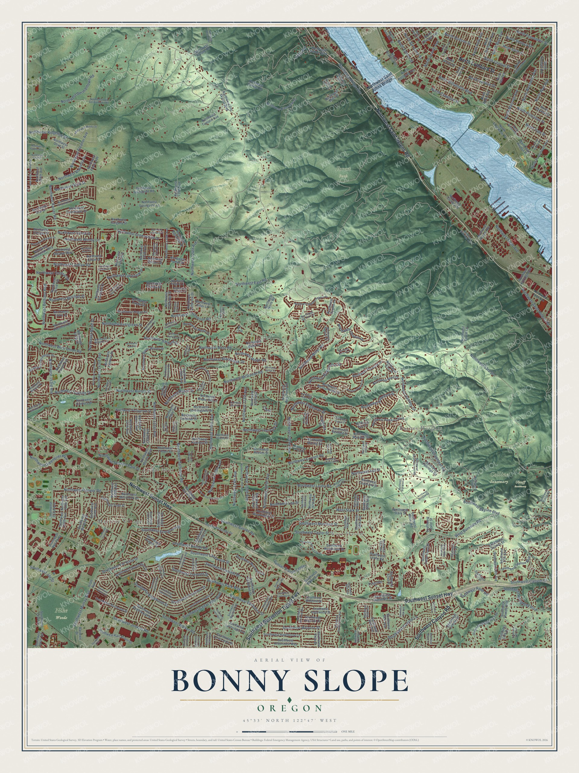
Explore Bonny Slope, Oregon from a whole new perspective. Created using aerial imagery and detailed geographic data, this map captures Bonny Slope building by building, with labeled streets, familiar landmarks, and shaded topographical relief that highlights the natural contours of the landscape.
Combining modern data with the timeless character of a vintage atlas, this map is just as interesting up close as it is beautiful on the wall. Whether you grew up in Bonny Slope, spent memorable years there, or call it home today, this unique map is a great way to celebrate a place that means something to you. Zoom in on the preview to look for your street, and then order a print to put your memories on the wall.
Three ways to hang it

Unframed archival matte, a black wood frame or a white wood frame.
Up close
Geography Worth Displaying
This map was created using accurate cartographic data and authoritative geographic sources, including the U.S. Geological Survey and the Census Bureau. The map brings together terrain, waterways, roads, and building detail. The majority of the streets are labeled, houses are accurately depicted, and the topography is derived from government sources. Combining local data with carefully composed color and shading leads to this beautifully detailed Bonny Slope artwork for your wall.
Rather than simply showing street outlines, we’ve included as many of the street names as we could reasonably fit on the map while keeping their names legible. Zoom in on the high resolution preview to see exactly what’s on the map. We truly set out to create a statement piece for anyone who loves Bonny Slope. So whether it’s for you, or a gift for someone you love, we hope this map of Bonny Slope brings back fond memories.
Read the story behind this map: Detailed Map of Bonny Slope, Oregon.

Find your street
Names on the Bonny Slope map
Every name below is printed on this map. Look for your street, your school, the park where you played, or the pond down the road.
Places and landmarks8
- West Haven
- Collins Sanctuary
- Forest Park
- Nike Woods
- Uhtoff Sanctuary
- Marlene Village
- Cedar Mill
- Barnes Heights
Streets and roads361
- Southwest Sunset Highway
- Northwest Sunset Highway
- Northwest Saint Helens Road
- Southwest Beaverton Tigard Fwy
- North Lombard Street
- Southwest Canyon Road
- Southwest Barnes Road
- Southwest Park Way
- Northwest 114th Avenue
- Northwest Lost Park Drive
- Northwest Miller Road
- Southwest Butner Road
- West Burnside Road
- Northwest 112th Avenue
- Crest
- Northwest Skyline Boulevard
- Northwest Saltzman Road
- Northwest Cornell Road
- Northwest Thompson Road
- Northwest Germantown Road
- Northwest Kaiser Road
- Northwest Laidlaw Road
- Southwest Walker Road
- North Willamette Boulevard
- Northwest Front Avenue
- Southwest Cedar Hills Boulevard
- Northwest 53rd Drive
- Southwest Murray Boulevard
- Southwest Jenkins Road
- North Syracuse Street
Show all 361 streets
- Northwest McDaniel Road
- North Princeton Street
- Northwest Leahy Road
- Southwest Canyon Lane
- Southwest Foothill Drive
- North Ivanhoe Street
- North Edison Street
- North Central Street
- Southwest Taylor Street
- Northwest 124th Avenue
- North Wall Avenue
- Southwest Edgewood Street
- Northwest 118th Avenue
- Northwest 143rd Avenue
- Northwest Bridge Avenue
- Northwest Birkendene Street
- Northwest Bethany Boulevard
- Southwest Canyon Court
- Southwest Morrison Street
- Northwest 153rd Avenue
- North Crawford Street
- Northwest Oakhills Drive
- Northwest Greenbrier Parkway
- Northwest West Union Road
- North Polk Avenue
- Northwest Greenwood Drive
- North Hudson Street
- Northwest Chapin Drive
- Northwest Science Park Drive
- Southwest Humphrey Boulevard
- Northwest 119th Avenue
- Northwest 113th Avenue
- North Burr Avenue
- North Macrum Avenue
- Northwest 107th Avenue
- Northwest 131st Avenue
- Northwest Pioneer Road
- Northwest Ash Street
- West Stark Street
- Northwest Eleanor Avenue
- Northwest Engleman Street
- Northwest Greenleaf Road
- Northwest Hartford Street
- Northwest Central Drive
- Southwest Faircrest Street
- Southwest Berkshire Street
- North Yale Street
- Northwest Blackhawk Drive
- North Westanna Avenue
- North Seneca Street
- Northwest Burton Street
- Northwest Ridgeline Street
- Southwest Melnore Street
- Northwest Evergreen Street
- Northwest Banff Drive
- Northwest West Road
- Southwest Lanewood Street
- North Fessenden Street
- Southwest Tremont Street
- Sunset Transit Center
- Northwest 102nd Avenue
- Northwest Delia Street
- Northwest Rossetta Street
- Northwest Hazeltine Street
- Southwest Evergreen Street
- Northwest Ridge Road
- Northwest Ramsey Drive
- Southwest Jay Street
- Southwest Far Vista Drive
- Northwest Mitchell Street
- Northwest Lakeview Drive
- Lilac Avenue
- Northwest East Road
- Northwest Wendy Lane
- North Leavitt Avenue
- Southwest Raab Road
- Northwest Vance Drive
- Northwest Lee Street
- Northwest Waker Drive
- Northwest Saint Johns Bridge
- Southwest Washington Street
- Northwest Barnes Road
- Northwest Devoto Lane
- Northwest Linmere Drive
- Southwest Devonshire Drive
- Southwest 58th Avenue
- Northwest 158th Avenue
- Southwest Baltic Avenue
- Southwest Intermark Street
- Northwest Springville Road
- Southwest Skyline Boulevard
- Southwest Hewett Boulevard
- Southwest Canyon Drive
- Northwest Marshall Street
- North Decatur Street
- Northwest 130th Avenue
- Northwest Murray Boulevard
- Northwest Perimeter Drive
- Northwest 137th Avenue
- Northwest Pinnacle Drive
- Southwest Lynnridge Avenue
- Northwest Mill Pond Road
- North Smith Street
- North Buchanan Avenue
- Southwest 84th Avenue
- Northwest Kearney Street
- North Ida Avenue
- Southwest Wilshire Street
- Northwest Bartholomew Drive
- Northwest Bauer Woods Drive
- Southwest 153rd Drive
- Southwest Leahy Road
- North Jersey Street
- Northwest 128th Avenue
- Southwest Karl Braun Drive
- Northwest Reeves Street
- Southwest Hawthorne Lane
- Northwest 153rd Terrace
- Northwest Arcade Road
- Northwest 133rd Avenue
- Southwest Burlwood Street
- North Alma Avenue
- Northwest Olive Street
- Southwest Catlin Crest Drive
- Southwest 144th Avenue
- North Edgewater Street
- Southwest Muirwood Drive
- Northwest 97th Avenue
- North Gilbert Avenue
- Northwest Old Skyline Boulevard
- North Van Houton Place
- North Bradford Street
- Southwest Arborcrest Way
- Southwest Brightwood Street
- Northwest Copeland Street
- Southwest Salmon Street
- Southwest Todd Street
- Northwest College Drive
- Northwest Benfield Drive
- Northwest 126th Avenue
- Northwest Springville Lane
- Southwest Meadow Drive
- North Chicago Avenue
- Northwest 135th Avenue
- Northwest North Road
- Southwest Koll Parkway
- North Portsmouth Avenue
- Northwest Andalusian Way
- Northwest 147th Place
- Northwest Ashbrook Drive
- Northwest Pettygrove Street
- Southwest Aragon Street
- Northwest 150th Avenue
- Northwest Mill Creek Drive
- Northwest Twinflower Drive
- Northwest Hawkins Boulevard
- Northwest Aberdeen Drive
- Northwest Tualatin Avenue
- Northwest 81st Place
- Southwest 88th Avenue
- Northwest Riverview Drive
- Bardeen Drive
- Southwest Corby Drive
- Southwest Westhaven Drive
- Southwest 57th Avenue
- Northwest Penridge Road
- Southwest Parkwood Drive
- Northwest Sunningdale Drive
- Northwest Jenne Avenue
- Southwest 130th Avenue
- Northwest Troon Drive
- Northwest 111th Avenue
- Northwest Harbor Boulevard
- North Depauw Street
- Northwest Coleman Drive
- Northwest Oxbridge Drive
- Northwest 128th Terrace
- Southwest Inglewood Street
- Northwest Hogan Street
- Northwest Reed Drive
- Northwest Culebra Street
- Northwest Welsh Drive
- Northwest Decatur Way
- Southwest Miller Road
- Northwest Filbert Street
- 145th Avenue
- Northwest Malia Lane
- Northwest Forest Lane
- Northwest Silverleaf Drive
- Southwest 55th Drive
- Northwest Lilium Drive
- Northwest Energia Street
- Northwest Hunters Drive
- Northwest Graf Street
- Northwest Maring Drive
- Southwest Imperial Drive
- Northwest Bannister Drive
- Northwest Doane Avenue
- Northwest 110th Avenue
- Northwest Mills Street
- Southwest 82nd Place
- Northwest Hamel Drive
- Southwest 150th Avenue
- Northwest 140th Avenue
- Northwest Maple Hill Lane
- North Kimball Avenue
- Northwest Forest Avenue
- Northwest Kittridge Avenue
- North Pittsburg Avenue
- Southwest 81st Avenue
- Northwest Payne Drive
- Southwest Terra Linda Street
- Southwest Spring Lane
- Northwest Bertani Street
- Southwest Vista Drive
- Northwest 86th Avenue
- Southwest 154th Terrace
- Northwest Findley Street
- Southwest Teufel Street
- Northwest Stark Street
- Northwest 139th Avenue
- Engleman Street
- Northwest Hiller Lane
- Northwest Gargany Street
- Southwest 153rd Avenue
- Northwest Fresia Avenue
- 114th Street
- Brookridge Street
- Southwest Burbank Avenue
- Northwest Overton Drive
- Southwest 132nd Avenue
- Northwest Old Germantown Road
- Northwest Lovejoy Street
- North Tyler Avenue
- Southwest Scholls Ferry Road
- Southwest Douglas Street
- Southwest 61st Drive
- Northwest 132nd Avenue
- Southwest Roxbury Avenue
- Southwest Garden View Avenue
- Northwest Lorraine Drive
- Southwest 90th Avenue
- Northwest Skyline Heights Drive
- Southwest 87th Avenue
- Southwest Mayfield Avenue
- Northwest 87th Avenue
- Northwest Spencer Street
- Southwest 89th Avenue
- Northwest 88th Avenue
- Northwest 144th Avenue
- Northwest 159th Avenue
- Southwest 83rd Avenue
- Northwest Wismer Drive
- Northwest Norwich Street
- Northwest Skyline Crest Road
- Northwest Big Fir Circle
- Northwest Wildrose Drive
- Northwest Minda Street
- North Willamette Lane
- Southwest 85th Avenue
- Northwest Hilltop Road
- Northwest Twoponds Drive
- Northwest Ryan Street
- Northwest De Voto Lane
- Southwest 67th Place
- Northwest Kenny Terrace
- Northwest Bailey Street
- Northwest Whistler Lane
- Northwest 99th Avenue
- Northwest Alsace Lane
- Northwest Dover Street
- Southwest 119th Avenue
- Northwest Avignon Lane
- Northwest Yeon Avenue
- Northwest Cedar Hills Boulevard
- Southwest Lynnridge Street
- Southwest Huntington Avenue
- Northwest Random Road
- Southwest Viewmont Drive
- North Charleston Avenue
- Northwest Murdock Street
- Southwest Wynwood Avenue
- North Van Houten Avenue
- Northwest Newton Road
- Northwest 123rd Avenue
- Northwest Creekview Drive
- Northwest Mayfield Road
- Northwest Melody Lane
- Northwest Falconridge Lane
- Southwest Glenhaven Street
- Northwest 127th Avenue
- Northwest Lost Springs Terrace
- Southwest Spring Crest Drive
- Northwest Cedar Falls Drive
- Southwest Dellwood Avenue
- Northwest Benson Street
- Northwest Brynwood Lane
- Northwest 129th Place
- Northwest 118th Place
- Northwest Abbey Road
- Southwest 141st Avenue
- Northwest Dumar Lane
- Southwest Hilldale Avenue
- Northwest Crossing Drive
- Southwest 78th Avenue
- Northwest Tradewind Street
- Northwest Harvest Hill Drive
- Northwest Ernst Street
- Thompson Trail
- Southwest Maple Lane
- Southwest 123rd Avenue
- Southwest Marlow Avenue
- Northwest Lombardy Drive
- Northwest Leahy Terrace
- Northwest Caitlin Terrace
- Northwest Willbridge Avenue
- Northwest Jewell Lane
- Northwest 121st Place
- Southwest Domino Street
- Southwest Eastridge Street
- Northwest Raywood Lane
- Northwest 94th Avenue
- Southwest 121st Avenue
- Northwest Diamond Drive
- Northwest Lariat Court
- Southwest 54th Avenue
- Northwest Fullner Court
- Southwest 71st Avenue
- Northwest 125th Place
- Northwest 141st Place
- Northwest Ogden Street
Names are listed as they appear on the printed map. Zoom into the product photos to find them.
About Bonny Slope, Oregon
C.D. Bruun platted Bonny Slope in 1931 for Western Oregon Farms, as the Depression began. He split the land into lots of about two acres. He built cheap, unfinished starter houses and sold them for buyers to finish. Many of those first small houses still sit inside larger homes today.
During Prohibition, moonshiners worked in the Bonny Slope woods, close to the Portland market. One hid his still beneath a plank bridge, behind logs stacked to look solid. A buyer drove onto the bridge, went to a trap door and picked up his liquor. Federal agents later raided the stills.
- Early logging and roadsE.O. Potter bought the local sawmill from Charles Thomas in 1903 and replaced its oxen and horses with steam engines. By 1908 he had built a pole road, where a steam train rode on log rails. He planked Saltzman and Thompson roads with his own timber for the heavy wagons.
Keep exploring Oregon
Bonny Slope is one of 592 Oregon towns we've mapped. Every dot on the map is a print of its own.
The search covers every state, Oregon first.
Near Bonny Slope
Order 2 or more town maps and save 10%. Shown in the size and finish you picked above, so they hang as a set.
- Northwest Heights 12" x 18" / Archival Matte Print $39.99
- Cedar Mill 12" x 18" / Archival Matte Print $39.99
- Forest Park 12" x 18" / Archival Matte Print $39.99


More maps nearby: West Haven-Sylvan, Marlene Village, Bethany, Oak Hills and Cedar Hills.
The art of mapping a place
How This Map Was Made
Real places. Remarkable detail. Discover the layers that turn geographic data into a map of home.

The view from above
Aerial imagery reveals the character of the land: woodland, open fields, and the patterns of a place.

The shape of the land
Elevation data brings hills, valleys, and subtle changes in the landscape into view.

The details of home
Roads, waterways, and building footprints come together to make the map feel unmistakably local.

Geography becomes art
Considered color, shading, and typography bring the layers together in a map made for your wall.


Process illustrated with Mendon, Massachusetts. Aerial imagery: USDA NAIP. Terrain: USGS 3D Elevation Program. Map details and finished artwork: KNOWOL.
The Details
About This Print
Choose an archival matte print, or a black or white Ayous wood frame. The archival matte print is unframed.
Select your size and finish above to see the matching product image and price.
Materials & Craftsmanship
A contemporary map with the character of a classic atlas, printed on archival matte paper. Optional frames are made from Ayous wood.
Your printed map does not include the watermark shown in the full-map preview.
Shipping & Delivery
Free shipping within the United States. Every print is made to order in the USA.
Buying a gift? Add a note in your cart and we'll include it. We never put prices in the package.
Prints ship within 2 to 3 business days. Allow 7 to 10 days total from ordering for delivery. Timing may vary during holidays or periods of high order volume.
Read our shipping policy.
Returns and damaged prints
Each print is made to order. Change-of-mind refunds are not available after production.
If your print arrives damaged, misprinted or incorrect, contact support@knowol.com within 30 days of receiving it. Include your order number, photos and a description of the issue.
Read our full refund and replacement policy. For questions about your order, email support@knowol.com.