


Search for another town


Free U.S. delivery 7 to 10 days after you order
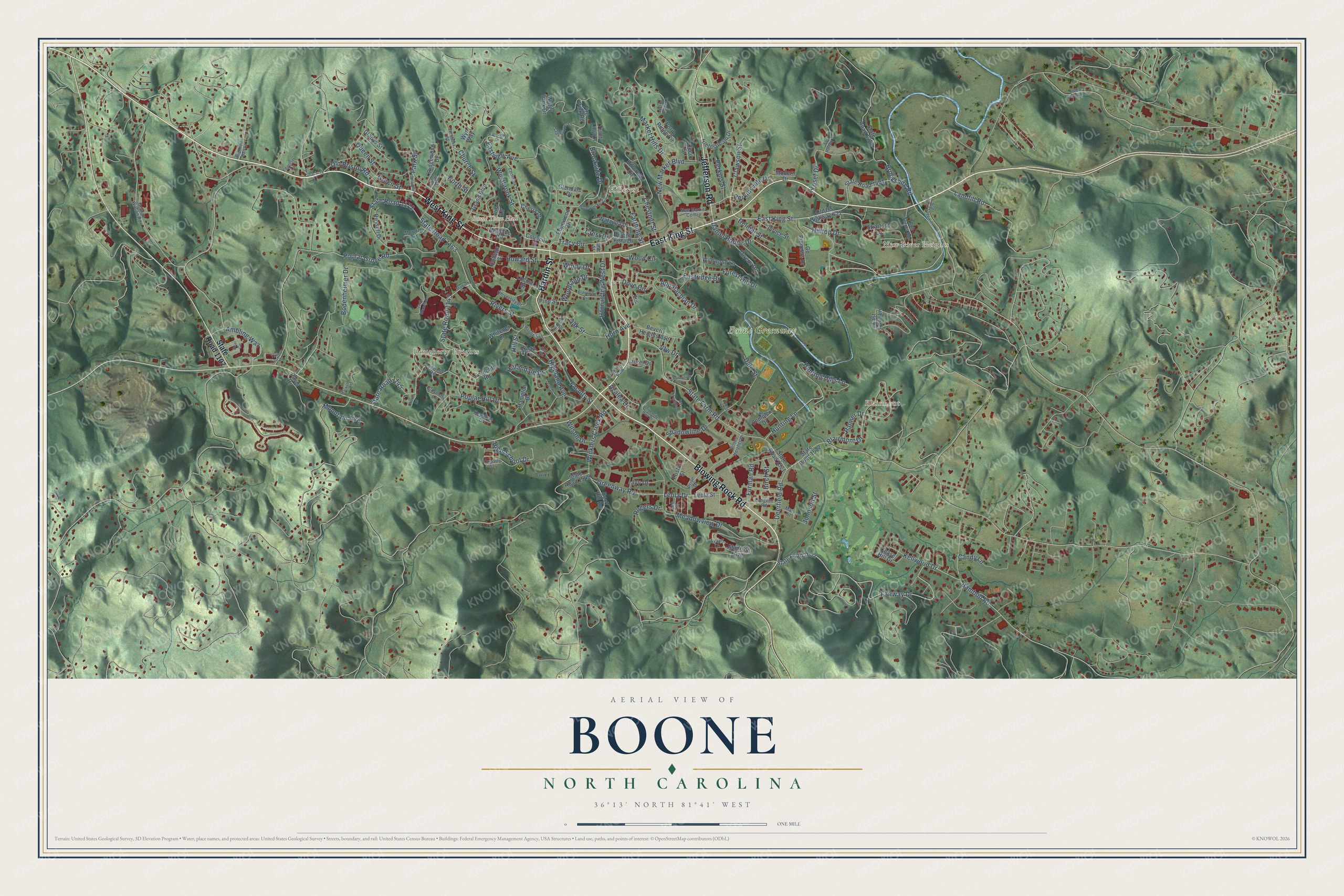
Boone, North Carolina Map Art
Building by building, with labeled streets and shaded relief.
12" x 18" Archival Matte Print
A Map of Home. A Work of Art.
Explore Boone, North Carolina from a whole new perspective. Created using aerial imagery and detailed geographic data, this map captures Boone building by building, with labeled streets, familiar landmarks, and shaded topographical relief that highlights the natural contours of the landscape.
Combining modern data with the timeless character of a vintage atlas, this map is just as interesting up close as it is beautiful on the wall. Whether you grew up in Boone, spent memorable years there, or call it home today, this unique map is a great way to celebrate a place that means something to you. Zoom in on the preview to look for your street, and then order a print to put your memories on the wall.
Three ways to hang it

Unframed archival matte, a black wood frame or a white wood frame.
Up close
Geography Worth Displaying
This map was created using accurate cartographic data and authoritative geographic sources, including the U.S. Geological Survey and the Census Bureau. The map brings together terrain, waterways, roads, and building detail. The majority of the streets are labeled, houses are accurately depicted, and the topography is derived from government sources. Combining local data with carefully composed color and shading leads to this beautifully detailed Boone artwork for your wall.
Rather than simply showing street outlines, we’ve included as many of the street names as we could reasonably fit on the map while keeping their names legible. Zoom in on the high resolution preview to see exactly what’s on the map. We truly set out to create a statement piece for anyone who loves Boone. So whether it’s for you, or a gift for someone you love, we hope this map of Boone brings back fond memories.
Read the story behind this map of Boone, North Carolina from 2026.

Find your street
Names on the Boone map
Every name below is printed on this map. Look for your street, your school, the park where you played, or the pond down the road.
Places and landmarks6
- Boone Town Hall
- Blairmont
- Boone Greenway
- New River Heights
- Dougherty Heights
- Hillcrest
Streets and roads177
- Blowing Rock Road
- West King Street
- East King Street
- Hardin Street
- Jefferson Road
- Brookside Drive
- Tracy Circle
- Daniel Boone Drive
- Fairway Drive
- Leola Drive
- Greenway Road
- Appalachian Drive
- Clawson Street
- Old Bristol Road
- State Road 1163
- State Road 1143
- Kellwood Drive
- Eastview Avenue
- Poplar Grove Road
- State Farm Road
- Queen Street
- Meadowview Drive
- Bodenheimer Drive
- State Road 1172
- Rivers Street
- Blairmont Drive
- Deerfield Road
- State Road 1145
- Winklers Creek Road
- Brookshire Road
Show all 177 streets
- Hunting Hills Lane
- Horn in the West Drive
- Bamboo Road
- Highland Avenue
- Forest Hill Drive
- Poplar Hill Drive
- New Market Boulevard
- Market Hills Drive
- Dale Street
- Yosef Drive
- Faculty Street
- Oak Street
- Howard Street
- Green Street
- Hunting Lane
- Perkinsville Drive
- Ambling Way
- Furman Road
- High School Drive
- Shadowline Drive
- Hillandale Drive
- Farthing Street
- Westbrook Street
- Chestnut Street
- Church Street
- Park Street
- Woodland Drive
- Mountain Aire
- Johnson Street
- Dove Circle
- Hill Street
- Hilltop Drive
- Landfill Road
- Delmar Street
- Crest Drive
- Perkins Street
- Ivy Drive
- Rogers Drive
- Wood Circle
- Eastridge Drive
- Palmer Drive
- Vfw Drive
- Azalea Drive
- Wilson Drive
- Windy Drive
- Birch Street
- Candy Lane
- Horn Avenue
- North Street
- State Road 1107
- Hillcrest Circle
- Cherry Drive
- Edgewood Drive
- Councill Street
- Old US Highway 421
- Beverly Heights Avenue
- State Road 1602
- Fieldstream Drive
- Deck Hill Road
- State Road 1521
- State Road 1522
- State Road 1328
- Fire Pink Road
- Madison Avenue
- Grand Boulevard
- North Ridge Circle
- Go Pioneers Drive
- State Road 1549
- State Road 1401
- Locust Street
- Laurel Drive
- Glendale Drive
- Wallace Circle
- Wildwood Lane
- Ridgewood Drive
- Watauga Drive
- Chase Hill Drive
- Owens Drive
- Whitener Drive
- Spruce Street
- Complex Drive
- Pine Street
- Russell Drive
- Water Tank Drive
- Modern Drive
- Gladys Street
- Leola Street
- Buena Vista Drive
- Stratford Lane
- Iris Lane
- Hampton Drive
- College Street
- Postal Street
- Cecil Street
- Ferncliff Road
- East Cove Lane
- Misty Lane
- Trout Lilly Lane
- Davis Drive
- Wyn Way
- Dogwood Road
- George Wilson Road
- Boone Heights Drive
- New Market Centre
- Keystone Drive
- University Drive
- Eric Lane
- Longvue Road
- Bub Teems Road
- Moretz Drive
- Pride Drive
- Clement Street
- Holmes Drive
- Coventry Lane
- Psi Drive
- Zeb Street
- Mary Street
- Realty Row
- Ayers Lane
- Avanti Lane
- Mac Street
- Eastview Drive
- Pinnacle Drive
- Stadium Drive
- Junaluska Road
- University Hall Drive
- Honeysuckle Lane
- Eastbrook Drive
- Jack Branch Drive
- Crossing Way
- State Road 1514
- Lady Slipper Lane
- Maryah Drive
- Blanwood Avenue
- Tulip Tree Lane
- Ivy Terrace Drive
- Bear Circle
- Eli Hartley Drive
- Sunnyside Drive
- Leah Drive
- Archie Carroll Road
- Straight Street
- Highland Hall Road
- Edgecliff Lane
- Wake Robin Lane
- Gragg Street
- Collins Lane
Names are listed as they appear on the printed map. Zoom into the product photos to find them.
About Boone, North Carolina
Boone is a town of 19,092 people in the Blue Ridge Mountains, and it is the county seat of Watauga County. It takes its name from Daniel Boone, who camped more than once at a spot most people place inside today's town limits. Two of his nephews, Jesse and Jonathan, sons of his brother Israel, belonged to Three Forks Baptist, the first church in town, which is still going. The town government received its charter in 1872.
Appalachian State University was founded here in 1899 and is now part of the University of North Carolina system. For years a narrow-gauge line nicknamed Tweetsie, the East Tennessee and Western North Carolina Railroad, served the town. The flood of 1940 carried off much of its track, and the owners chose not to rebuild it, so the trains never came back.
- Horn in the West since 1952Every summer since 1952, an outdoor drama about the early mountain settlers during the Revolutionary War has played in an amphitheater near town, with Daniel Boone as a character. Only the 2020 season was canceled, because of COVID-19. Ned Austin first played Boone, and his star stands on a pedestal on King Street. Glenn Causey then took the part for 41 years, and many local pictures of Boone still show his face.
- The Junaluska communityIn the hills just north of downtown, a free Black community has lived since before the Civil War. When integration came in the mid-20th century, many of its businesses closed as customers went downtown instead. Descendants of the first families still live in Junaluska, and its Mennonite Brethren church is one of the few in that denomination with a mostly African American congregation.
- Three titles in a rowAppalachian State's football team won national championships in 2005, 2006 and 2007. No other college in North Carolina has won an NCAA national title in football.
- Cold at 3,333 feetBoone sits at 3,333 feet, higher than any other town east of the Mississippi with more than 10,000 people. Snowfall averages nearly 25 inches a year, and on January 21, 1985, the temperature dropped to 24 degrees below zero.
Keep exploring North Carolina
Boone is one of 952 North Carolina towns we've mapped. Every dot on the map is a print of its own.
The search covers every state, North Carolina first.
Near Boone
Order 2 or more town maps and save 10%. Shown in the size and finish you picked above, so they hang as a set.
- Blowing Rock 12" x 18" / Archival Matte Print $39.99
- Valle Crucis 12" x 18" / Archival Matte Print $39.99
- Foscoe 12" x 18" / Archival Matte Print $39.99


More maps nearby: Cove Creek, Mabel, Seven Devils, Bethel and Banner Elk.
The art of mapping a place
How This Map Was Made
Real places. Remarkable detail. Discover the layers that turn geographic data into a map of home.

The view from above
Aerial imagery reveals the character of the land: woodland, open fields, and the patterns of a place.

The shape of the land
Elevation data brings hills, valleys, and subtle changes in the landscape into view.

The details of home
Roads, waterways, and building footprints come together to make the map feel unmistakably local.

Geography becomes art
Considered color, shading, and typography bring the layers together in a map made for your wall.


Process illustrated with Mendon, Massachusetts. Aerial imagery: USDA NAIP. Terrain: USGS 3D Elevation Program. Map details and finished artwork: KNOWOL.
The Details
About This Print
Choose an archival matte print, or a black or white Ayous wood frame. The archival matte print is unframed.
Select your size and finish above to see the matching product image and price.
Materials & Craftsmanship
A contemporary map with the character of a classic atlas, printed on archival matte paper. Optional frames are made from Ayous wood.
Your printed map does not include the watermark shown in the full-map preview.
Shipping & Delivery
Free shipping within the United States. Every print is made to order in the USA.
Buying a gift? Add a note in your cart and we'll include it. We never put prices in the package.
Prints ship within 2 to 3 business days. Allow 7 to 10 days total from ordering for delivery. Timing may vary during holidays or periods of high order volume.
Read our shipping policy.
Returns and damaged prints
Each print is made to order. Change-of-mind refunds are not available after production.
If your print arrives damaged, misprinted or incorrect, contact support@knowol.com within 30 days of receiving it. Include your order number, photos and a description of the issue.
Read our full refund and replacement policy. For questions about your order, email support@knowol.com.