
Search for another town


Free U.S. delivery 7 to 10 days after you order
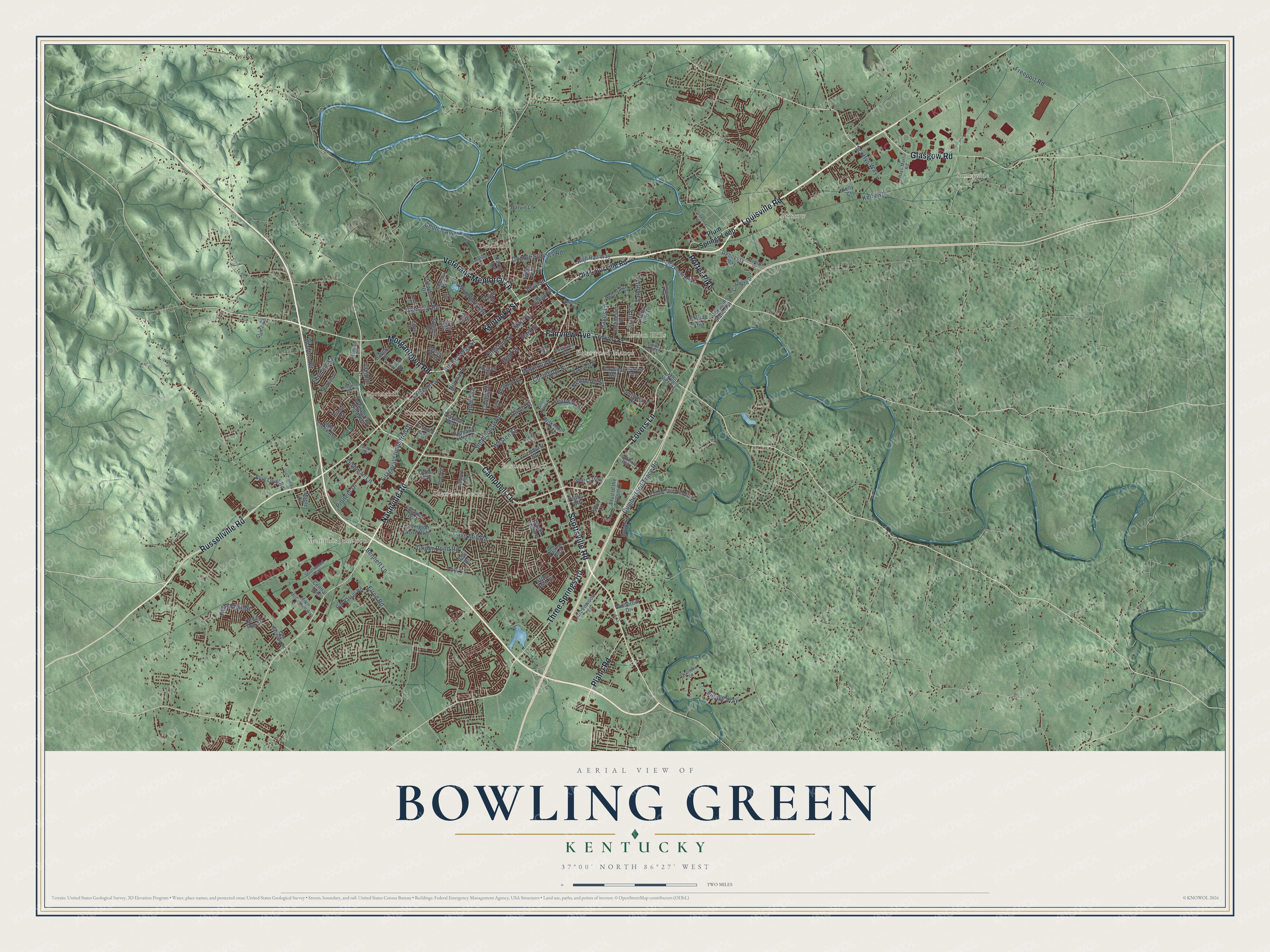
Bowling Green, Kentucky Map Art
Building by building, with labeled streets and shaded relief.
12" x 18" Archival Matte Print
A Map of Home. A Work of Art.
Explore Bowling Green, Kentucky from a whole new perspective. Created using aerial imagery and detailed geographic data, this map captures Bowling Green building by building, with labeled streets, familiar landmarks, and shaded topographical relief that highlights the natural contours of the landscape.
Combining modern data with the timeless character of a vintage atlas, this map is just as interesting up close as it is beautiful on the wall. Whether you grew up in Bowling Green, spent memorable years there, or call it home today, this unique map is a great way to celebrate a place that means something to you. Zoom in on the preview to look for your street, and then order a print to put your memories on the wall.
Three ways to hang it

Unframed archival matte, a black wood frame or a white wood frame.
Up close
Geography Worth Displaying
This map was created using accurate cartographic data and authoritative geographic sources, including the U.S. Geological Survey and the Census Bureau. The map brings together terrain, waterways, roads, and building detail. The majority of the streets are labeled, houses are accurately depicted, and the topography is derived from government sources. Combining local data with carefully composed color and shading leads to this beautifully detailed Bowling Green artwork for your wall.
Rather than simply showing street outlines, we’ve included as many of the street names as we could reasonably fit on the map while keeping their names legible. Zoom in on the high resolution preview to see exactly what’s on the map. We truly set out to create a statement piece for anyone who loves Bowling Green. So whether it’s for you, or a gift for someone you love, we hope this map of Bowling Green brings back fond memories.
Read the story behind this map of Bowling Green, Kentucky from 2026.

Find your street
Names on the Bowling Green map
Every name below is printed on this map. Look for your street, your school, the park where you played, or the pond down the road.
Places and landmarks10
- Sunnyside
- Memphis Junction
- Bristow
- Springhill
- Delafield
- Eastland Park
- Shawnee Estates
- Indian Hills
- Briarwood Manor
- Crestmoor
Streets and roads147
- Louisville Road
- Russellville Road
- Scottsville Road
- Kentucky Street
- Nashville Road
- Campbell Lane
- Fairview Avenue
- Veterans Memorial Lane
- Lovers Lane
- Morgantown Road
- Glasgow Road
- Three Springs Road
- Porter Pike
- Plano Road
- State Street
- Big Red Way Street
- Covington Street
- Smallhouse Road
- Cave Mill Road
- Cumberland Trace Road
- Chestnut Street
- Freeport Road
- Church Avenue
- Park Street
- Grider Pond Road
- Magnolia Street
- Glen Lily Road
- Clay Street
- Kelly Road
- Fitzgerald Industrial Drive
Show all 147 streets
- High Street
- Double Springs Road
- Elrod Road
- Westen Street
- Scottys Way
- Lois Lane
- Fairway Street
- Creason Street
- Hayes Lane
- Dishman Lane
- Cabell Drive
- Pioneer Drive
- Village Way
- Scott Lane
- Talbott Drive
- Bennett Lane
- Woodford Avenue
- Red Maple Street
- Normal Drive
- Walden Road
- Newberry Street
- Fern Hill Street
- Oliver Street
- Rodes Drive
- Old Louisville Road
- Plum Springs Loop
- Wilkinson Trce
- Blue Level Road
- Nutwood Street
- College Street
- Highland Way
- Ironwood Drive
- Corvette Drive
- Old Porter Pike
- Kenton Street
- Mount Ayr Circle
- Covington Grove Boulevard
- Pascoe Boulevard
- Whispering Hills Boulevard
- Woodhurst Street
- Raven Avenue
- Hennessy Way
- Emmett Avenue
- Crewdson Drive
- Indian Hills Drive
- Mount Victor Lane
- Fruit of the Loom Drive
- Fair Street
- Greenwood Lane
- Cal Batsel Road
- Shive Lane
- Webb Avenue
- High Rail Way
- Vanderbilt Drive
- McFadin Station Street
- Lynwood Way
- Moss Creek Avenue
- Searcy Way
- Newman Way
- Pedigo Way
- Dorchester Drive
- Jennings Court
- Central Avenue
- Garvin Lane
- Virginia Drive
- Maple Lane
- North Mill Avenue
- Clifford Way
- Cardinal Way
- Guinn Court
- Patton Way
- Loop Street
- Rosie Court
- Cedar Run Street
- Payne Street
- Sandra Street
- Butler Way
- Stone Briar Street
- Oriole Street
- Bow Drive
- Dennis Way
- Kelly Court
- Cove Drive
- Cumberland Ridge Avenue
- Kinlock Lane
- Mitch McConnell Way
- Wakefield Street
- Traditions Boulevard
- Jackson Street
- Park Hills Street
- Shannon Way
- Mohawk Drive
- Overlook Lane
- East McLellan Road
- Hays-Martin Road
- Eastwood Avenue
- South Park Drive
- Southwood Court
- Ewing Ford Road
- Yuma Drive
- Barnard Way
- Seymour Drive
- Turner Court
- Lain Avenue
- Cemetery Road
- Ashley Circle
- Commerce Street
- Tomblinson Way
- Shive Boulevard
- Interstate Drive
- Old Tram Road
- Ridgewood Drive
- Natcher Lane
- Carla Drive
- Kirby Drive
- Avon Avenue
- Jfs Circle
Names are listed as they appear on the printed map. Zoom into the product photos to find them.
About Bowling Green, Kentucky
Bowling Green is the county seat of Warren County, and its 72,294 people in 2020 made it Kentucky's third-largest city. By 1778 settlers had put up McFadden's Station on the Barren River's north bank. The town grew from the homesteads of Robert and George Moore and General Elijah Covington. The city says the county commissioners named it "Bolin Green" at their first meeting in 1798. The name honored New York City's Bowling Green, where patriots pulled down King George III's statue and melted the lead into bullets.
When the Civil War began, the town declared itself neutral. Its river and railroad still made both sides want it. On September 18, 1861, about 1,300 Confederate troops under General Simon Bolivar Buckner marched in from Tennessee. That November, the provisional Confederate government of Kentucky made Bowling Green its capital. Then Ulysses S. Grant's Union forces took Fort Henry and Fort Donelson, and on February 14, 1862, the Confederates started to pull out.
“[Vance] says that he has seen a turnip this fall that measures thirty-two inches around, and has a beet that weighs sixteen pounds and a half;... that corn in this country grows so fast that if you look at it the next, it has grown a foot higher; that the "little hickory twigs" growing in the barrens have roots as large as his legs...”
- Home of the Corvette since 1981In 1981 General Motors brought its Corvette assembly line to Bowling Green from St. Louis. Every Chevrolet Corvette since then has been built at the Bowling Green Assembly Plant. The National Corvette Homecoming began that same year and draws owners and car parades to town every year. The National Corvette Museum was built near the plant in 1994.
- Mules on the rails in 1832In 1832 a portage railway ran from the Barren River to the spot where the county courthouse now stands. Mules hauled freight and passengers along its tracks. The Louisville and Nashville Railroad came through in 1859 and tied the city to markets north and south. Its third and last station opened in 1925 and saw about 27 trains a day. After rail travel faded in the 1960s, the station became a museum.
- A teachers' school in 1906The Southern Normal School, founded in 1875, moved here from Glasgow in 1884. In 1906 its president and owner, Henry Hardin Cherry, gave it to the state. It became the start of the Western State Normal School, which trained teachers. The school grew into Western Kentucky University, the city's largest employer, with 3,274 workers in a 2022 report.
- A dressmaker's 200 workersDowntown business grew quickly after the Civil War, and many of its historic commercial buildings went up in the 1870s. One of the most important firms of the time was Carie Burnam Taylor's dressmaking company. By 1906 it employed more than 200 women.
Keep exploring Kentucky
Bowling Green is one of 659 Kentucky towns we've mapped. Every dot on the map is a print of its own.
The search covers every state, Kentucky first.
Near Bowling Green
Order 2 or more town maps and save 10%. Shown in the size and finish you picked above, so they hang as a set.
- Plum Springs 12" x 18" / Archival Matte Print $39.99
- Bristow 12" x 18" / Archival Matte Print $39.99
- Plano 12" x 18" / Archival Matte Print $39.99


More maps nearby: Rich Pond, Richardsville, Alvaton, Rockfield and Woodburn.
The art of mapping a place
How This Map Was Made
Real places. Remarkable detail. Discover the layers that turn geographic data into a map of home.

The view from above
Aerial imagery reveals the character of the land: woodland, open fields, and the patterns of a place.

The shape of the land
Elevation data brings hills, valleys, and subtle changes in the landscape into view.

The details of home
Roads, waterways, and building footprints come together to make the map feel unmistakably local.

Geography becomes art
Considered color, shading, and typography bring the layers together in a map made for your wall.


Process illustrated with Mendon, Massachusetts. Aerial imagery: USDA NAIP. Terrain: USGS 3D Elevation Program. Map details and finished artwork: KNOWOL.
The Details
About This Print
Choose an archival matte print, or a black or white Ayous wood frame. The archival matte print is unframed.
Select your size and finish above to see the matching product image and price.
Materials & Craftsmanship
A contemporary map with the character of a classic atlas, printed on archival matte paper. Optional frames are made from Ayous wood.
Your printed map does not include the watermark shown in the full-map preview.
Shipping & Delivery
Free shipping within the United States. Every print is made to order in the USA.
Buying a gift? Add a note in your cart and we'll include it. We never put prices in the package.
Prints ship within 2 to 3 business days. Allow 7 to 10 days total from ordering for delivery. Timing may vary during holidays or periods of high order volume.
Read our shipping policy.
Returns and damaged prints
Each print is made to order. Change-of-mind refunds are not available after production.
If your print arrives damaged, misprinted or incorrect, contact support@knowol.com within 30 days of receiving it. Include your order number, photos and a description of the issue.
Read our full refund and replacement policy. For questions about your order, email support@knowol.com.