


Search for another town


Free U.S. delivery 7 to 10 days after you order
Cherokee Village, Arkansas Map Art
Building by building, with labeled streets and shaded relief.
12" x 18" Archival Matte Print
A Map of Home. A Work of Art.
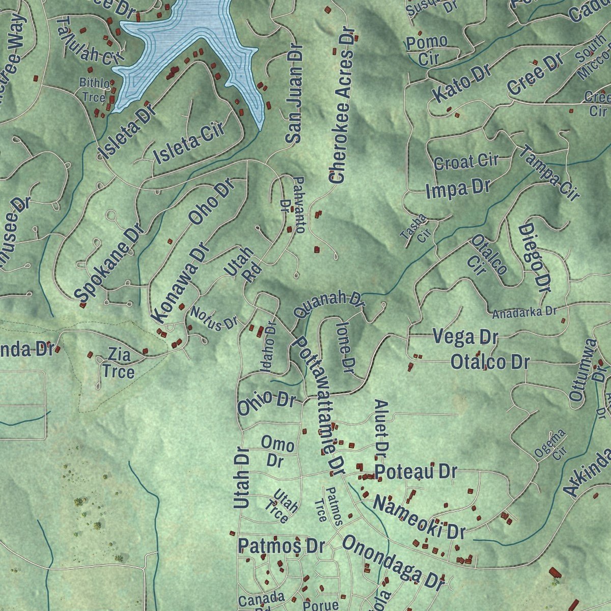
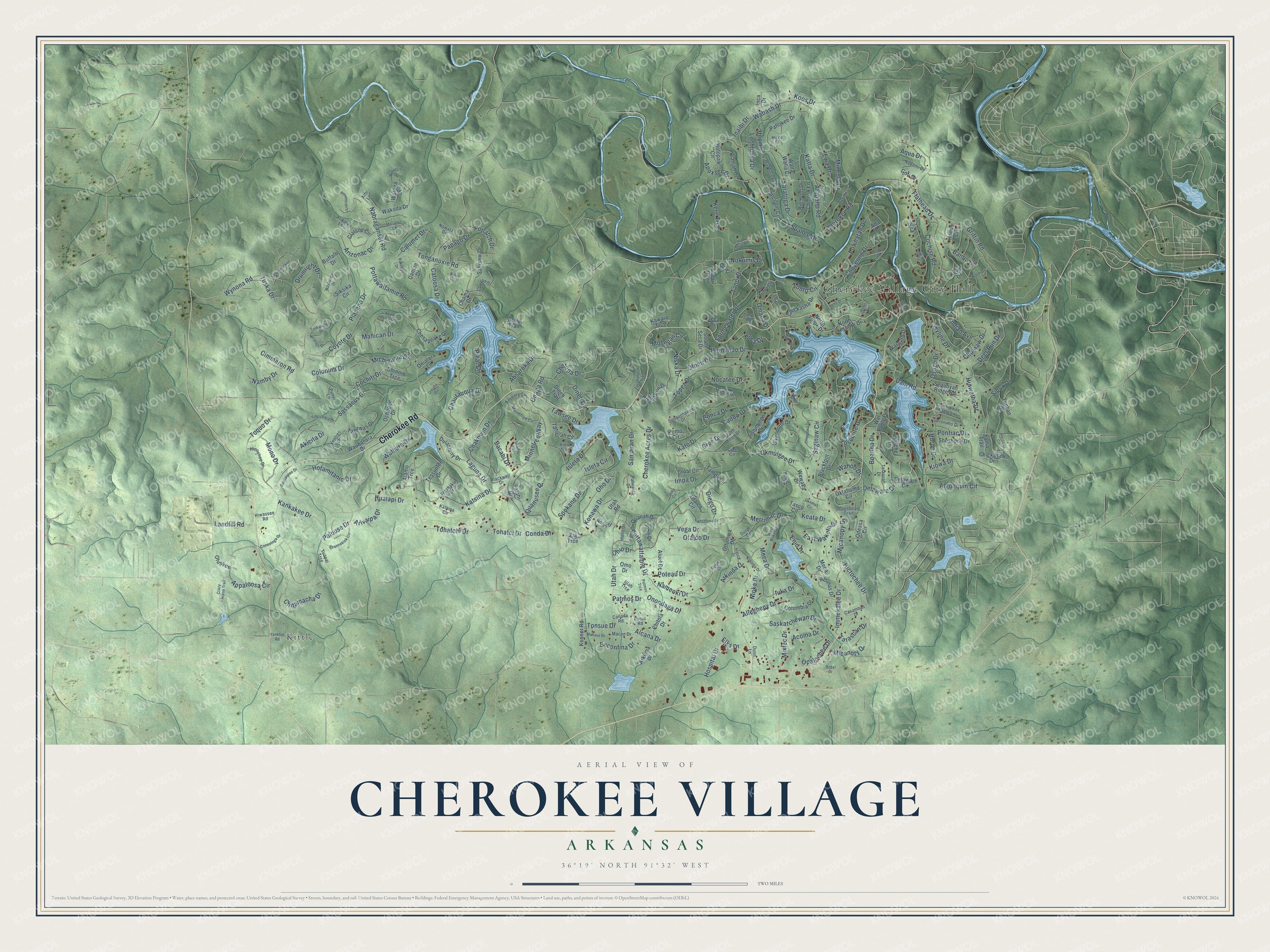
Explore Cherokee Village, Arkansas from a whole new perspective. Created using aerial imagery and detailed geographic data, this map captures Cherokee Village building by building, with labeled streets, familiar landmarks, and shaded topographical relief that highlights the natural contours of the landscape.
Combining modern data with the timeless character of a vintage atlas, this map is just as interesting up close as it is beautiful on the wall. Whether you grew up in Cherokee Village, spent memorable years there, or call it home today, this unique map is a great way to celebrate a place that means something to you. Zoom in on the preview to look for your street, and then order a print to put your memories on the wall.
Three ways to hang it

Unframed archival matte, a black wood frame or a white wood frame.
Up close
Geography Worth Displaying
This map was created using accurate cartographic data and authoritative geographic sources, including the U.S. Geological Survey and the Census Bureau. The map brings together terrain, waterways, roads, and building detail. The majority of the streets are labeled, houses are accurately depicted, and the topography is derived from government sources. Combining local data with carefully composed color and shading leads to this beautifully detailed Cherokee Village artwork for your wall.
Rather than simply showing street outlines, we’ve included as many of the street names as we could reasonably fit on the map while keeping their names legible. Zoom in on the high resolution preview to see exactly what’s on the map. We truly set out to create a statement piece for anyone who loves Cherokee Village. So whether it’s for you, or a gift for someone you love, we hope this map of Cherokee Village brings back fond memories.
Read the story behind this map of Cherokee Village, Arkansas from 2026.

Find your street
Names on the Cherokee Village map
Every name below is printed on this map. Look for your street, your school, the park where you played, or the pond down the road.
Places and landmarks2
- Cherokee Village City Hall
- Kittle
Streets and roads305
- Cherokee Road
- Cree Drive
- Dam Road
- Tonganoxie Road
- Pottawattamie Drive
- Onaga Road
- Okmulgee Drive
- Griffin Road
- Palouse Drive
- Flathead Drive
- Hiawatha Drive
- Wabash Drive
- Hernando Drive
- Saginaw Circle
- Pottawattamie Road
- Hotamitanio Drive
- Akicita Drive
- Powhatan Drive
- Toquo Drive
- Hualapi Drive
- Wahoo Drive
- Papago Drive
- Mineola Drive
- Deer Run Drive
- Algonquin Circle
- Otalco Drive
- Allegheny Drive
- Cherokee Acres Drive
- Wynona Road
- Saratoga Drive
Show all 305 streets
- Saskatchewan Drive
- Walhara Drive
- Isleta Drive
- Chautauqua Drive
- Topez Drive
- Cochise Road
- Inaibi Drive
- Merrimac Drive
- Tohatchi Drive
- Quanusee Drive
- Hictochee Drive
- Conda Drive
- Oho Drive
- Pinal Circle
- Nameoki Drive
- Spokane Drive
- Caddo Drive
- Tonto Circle
- Appaloosa Circle
- Potlatch Drive
- Piasano Drive
- Delaware Drive
- Cimmaron Road
- Chakowin Drive
- Lochloosa Drive
- Enconfina Drive
- Vega Drive
- Nocatee Drive
- Katsina Drive
- Enid Drive
- Pontiac Drive
- Tonsue Drive
- Otomi Drive
- Impa Drive
- Kankakee Drive
- Kato Drive
- Utah Drive
- Cochiti Drive
- Alcana Drive
- Sioux Drive
- Laguna Drive
- Chitamacha Drive
- Boanna Drive
- Nabraganset Road
- Hospital Drive
- Drumright Drive
- Namby Drive
- Michigama Drive
- Catoosa Drive
- San Juan Drive
- Kiowa Drive
- Onondaga Drive
- Mohegan Circle
- Sassacus Drive
- Cheyenne Drive
- Immokalee Drive
- Mahican Drive
- Banho Circle
- Iuka Drive
- Dineh Circle
- Yosemite Drive
- Iowa Drive
- Springwater Drive
- Minnetree Way
- Skyline Drive
- Konawa Drive
- Arizonac Drive
- Poteau Drive
- Aqua Drive
- Coyote Drive
- Kere Trce
- Katta Drive
- Tawsee Drive
- Mono Drive
- Nioka Drive
- Arapaho Road
- Arkinda Drive
- Keata Drive
- Diego Drive
- Chetopa Drive
- Colonina Drive
- Calumet Drive
- Absaroka Drive
- Indian Avenue
- East Waketa Drive
- Patmos Drive
- Micanopy Drive
- Arivaipa Drive
- Apoxsee Drive
- Bacabi Drive
- Opalochee Drive
- Landfill Road
- Niska Drive
- Taopi Drive
- Mixtec Drive
- Osage Drive
- Micanoty Drive
- Choctaw Drive
- Isleta Circle
- Acoma Drive
- Ponca Drive
- Nokomis Drive
- Tohatci Drive
- Tarascan Drive
- Tuska Drive
- Huron Drive
- Meca Drive
- Omaha Drive
- Suanee Drive
- Koos Drive
- Hopi Drive
- Elks Drive
- Ewa Drive
- Ohio Drive
- Wyandotte Drive
- Sequoyah Ridge Road
- Waubansia Drive
- Chesapeake Drive
- Sallisaw Drive
- North Lakeshore Drive
- Blackfoot Drive
- Croat Circle
- Columbia Drive
- Clatsop Circle
- Wakoda Drive
- Tanawas Drive
- Holopaw Circle
- Oklahoma Circle
- Ottumwa Drive
- Tallulah Circle
- Pahokee Drive
- Chickasaw Drive
- Mena Drive
- Talahi Drive
- Ocala Drive
- Ochopee Drive
- Taopi Trce
- Tishimingo Drive
- Shoshone Drive
- Otalco Circle
- Hondo Circle
- Chinook Lane
- Ione Drive
- Tessuntee Drive
- Seca Drive
- Tasco Circle
- Wewaka Drive
- Chickasha Drive
- Siksika Circle
- Tampa Circle
- Natchez Trce
- Dulastuny Drive
- Rising Sun Drive
- Hialeah Drive
- Walla Walla Drive
- Inca Drive
- Yancopin Circle
- Arkoma Drive
- Big Horn Drive
- Quanah Drive
- Goti Drive
- Ola Circle
- Kewe Drive
- Chitola Drive
- Warpath Drive
- Brule Trail
- Tunkan Drive
- War Eagle Drive
- Delaware Circle
- Atsinas Drive
- Alamo Trce
- Zia Trce
- Canute Drive
- Watoga Drive
- Kenner Road
- Ada Drive
- Oniatara Lane
- Aluet Drive
- Oluskee
- Yuma Trail
- North Yurok Drive
- Chinnio Trce
- South Seca Drive
- Kawaia Trce
- Pomo Circle
- Chama Drive
- Dineh Trail
- Odessa Circle
- Omo Drive
- Buffalo Drive
- Utah Road
- Uno Circle
- Chief White Eagle Lane
- Otter Drive
- Moonbeam Trail
- Washakie Drive
- Minnetree Circle
- Susquehanna Drive
- Geronimo Drive
- Hiwassee Road
- Canada Road
- Ventres Drive
- Kayenta Circle
- Wabbaseka Drive
- Katsina Circle
- Pahvanto Drive
- Telaquah Drive
- South Micco Drive
- Nowata Drive
- Idaho Drive
- Duroc Drive
- Hicoohee Drive
- Blackwell Drive
- Arikara Lane
- Macon Drive
- Coweta Drive
- Kolo Drive
- Nokomi Drive
- Caxambas Drive
- Porue Road
- West Tonto Circle
- Utah Trce
- Notus Drive
- Ozoo Road
- Punuk Lane
- Yuapai Trce
- Cree Circle
- Dunn Lane
- Lulu Drive
- Zuni Circle
- Qua Circle
- Athi Lane
- West Waketa Drive
- Chippewa Drive
- Morache Circle
- Potomac Drive
- Anadarka Drive
- Menifee Lane
- Raccoon Circle
- Shannakiok Circle
- Tushahoma Drive
- Santee Drive
- Okefenokee Drive
- Nicatous Drive
- Pro Shop Road
- Tasha Circle
- Crazy Horse Trail
- Keno Drive
- Mohave Drive
- Nakoma Drive
- Wewaka Circle
- Cusawatee Drive
- Nez Perce Drive
- Micco Drive
- Yankton Road
- Pequot Drive
- Atasca Drive
- Pemmican Lane
- Tuscumbia Drive
- Conestoga Drive
- Washunga Drive
- High Horse Trail
- Watoga Lane
- Omaha Circle
- Los Indios Drive
- Oraibi Lane
- Okemah Circle
- Bokchito Drive
- Patmos Trce
- Rebel Drive
- Ogema Circle
- Bithlo Trce
- Tonto Lane
- Kusa Circle
- Notus Trce
Names are listed as they appear on the printed map. Zoom into the product photos to find them.
About Cherokee Village, Arkansas
From the CALS Encyclopedia of Arkansas: "A retirement community in northeastern Arkansas, Cherokee Village was founded in 1954. Started as a 2,400-acre summer resort in the vein of the Wahpeton Inn at Hardy (Sharp County), Cherokee Village became the state’s leading retirement community by the early 1960s."
Keep exploring Arkansas
Cherokee Village is one of 658 Arkansas towns we've mapped. Every dot on the map is a print of its own.
The search covers every state, Arkansas first.
Near Cherokee Village
Order 2 or more town maps and save 10%. Shown in the size and finish you picked above, so they hang as a set.
- Highland 12" x 18" / Archival Matte Print $39.99
- Ash Flat 12" x 18" / Archival Matte Print $39.99
- Hardy 12" x 18" / Archival Matte Print $39.99


More maps nearby: Ozark Acres, Horseshoe Bend, Williford, Franklin and Mammoth Spring.
The art of mapping a place
How This Map Was Made
Real places. Remarkable detail. Discover the layers that turn geographic data into a map of home.

The view from above
Aerial imagery reveals the character of the land: woodland, open fields, and the patterns of a place.

The shape of the land
Elevation data brings hills, valleys, and subtle changes in the landscape into view.

The details of home
Roads, waterways, and building footprints come together to make the map feel unmistakably local.

Geography becomes art
Considered color, shading, and typography bring the layers together in a map made for your wall.


Process illustrated with Mendon, Massachusetts. Aerial imagery: USDA NAIP. Terrain: USGS 3D Elevation Program. Map details and finished artwork: KNOWOL.
The Details
About This Print
Choose an archival matte print, or a black or white Ayous wood frame. The archival matte print is unframed.
Select your size and finish above to see the matching product image and price.
Materials & Craftsmanship
A contemporary map with the character of a classic atlas, printed on archival matte paper. Optional frames are made from Ayous wood.
Your printed map does not include the watermark shown in the full-map preview.
Shipping & Delivery
Free shipping within the United States. Every print is made to order in the USA.
Buying a gift? Add a note in your cart and we'll include it. We never put prices in the package.
Prints ship within 2 to 3 business days. Allow 7 to 10 days total from ordering for delivery. Timing may vary during holidays or periods of high order volume.
Read our shipping policy.
Returns and damaged prints
Each print is made to order. Change-of-mind refunds are not available after production.
If your print arrives damaged, misprinted or incorrect, contact support@knowol.com within 30 days of receiving it. Include your order number, photos and a description of the issue.
Read our full refund and replacement policy. For questions about your order, email support@knowol.com.