
Search for another town


Free U.S. delivery 7 to 10 days after you order
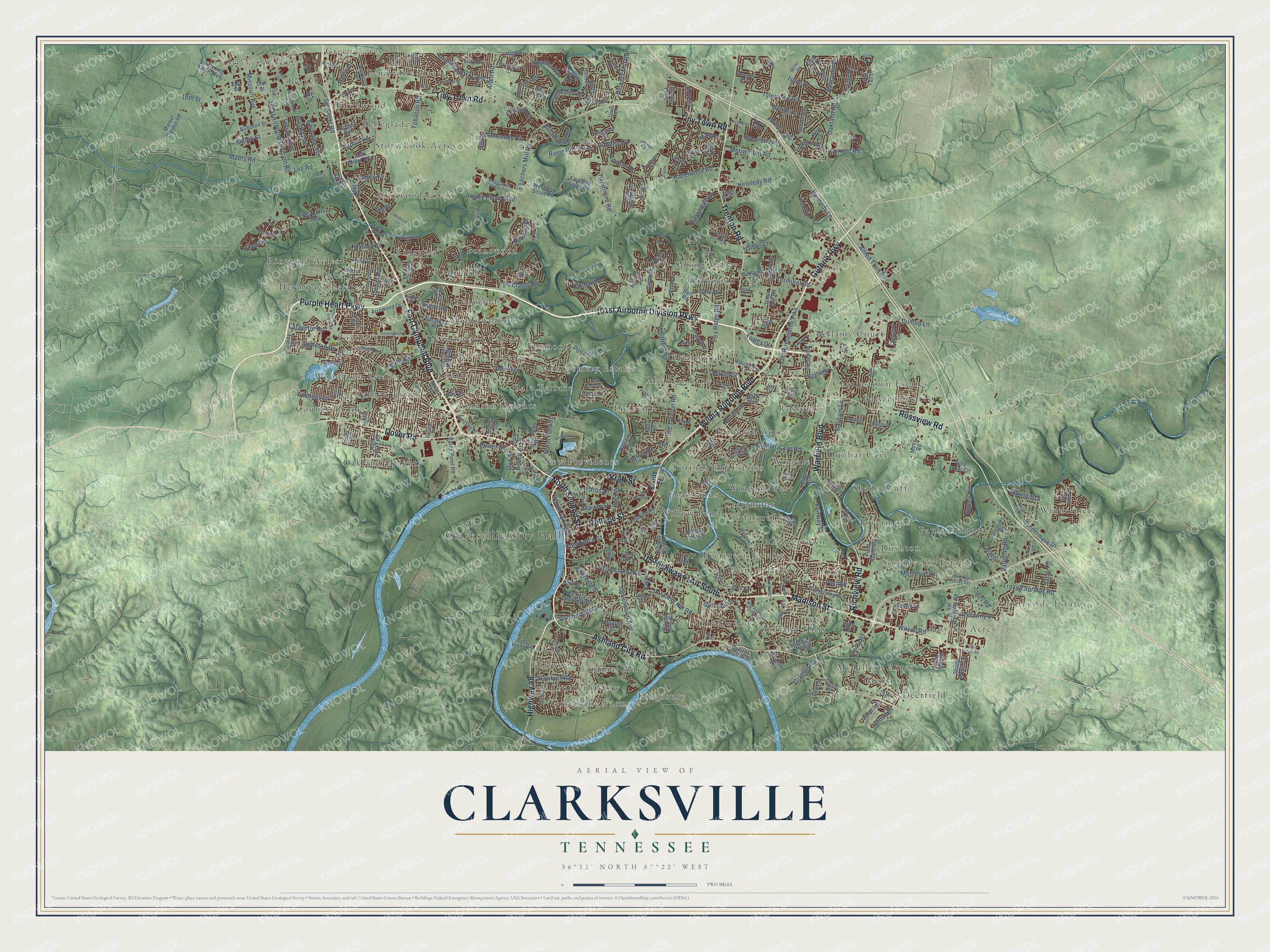
Clarksville, Tennessee Map Art
Building by building, with labeled streets and shaded relief.
12" x 18" Archival Matte Print
A Map of Home. A Work of Art.
Explore Clarksville, Tennessee from a whole new perspective. Created using aerial imagery and detailed geographic data, this map captures Clarksville building by building, with labeled streets, familiar landmarks, and shaded topographical relief that highlights the natural contours of the landscape.
Combining modern data with the timeless character of a vintage atlas, this map is just as interesting up close as it is beautiful on the wall. Whether you grew up in Clarksville, spent memorable years there, or call it home today, this unique map is a great way to celebrate a place that means something to you. Zoom in on the preview to look for your street, and then order a print to put your memories on the wall.
Three ways to hang it

Unframed archival matte, a black wood frame or a white wood frame.
Up close
Geography Worth Displaying
This map was created using accurate cartographic data and authoritative geographic sources, including the U.S. Geological Survey and the Census Bureau. The map brings together terrain, waterways, roads, and building detail. The majority of the streets are labeled, houses are accurately depicted, and the topography is derived from government sources. Combining local data with carefully composed color and shading leads to this beautifully detailed Clarksville artwork for your wall.
Rather than simply showing street outlines, we’ve included as many of the street names as we could reasonably fit on the map while keeping their names legible. Zoom in on the high resolution preview to see exactly what’s on the map. We truly set out to create a statement piece for anyone who loves Clarksville. So whether it’s for you, or a gift for someone you love, we hope this map of Clarksville brings back fond memories.
Read the story behind this map of Clarksville, Tennessee from 2026.

Find your street
Names on the Clarksville map
Every name below is printed on this map. Look for your street, your school, the park where you played, or the pond down the road.
Places and landmarks71
- Clarksville City Hall
- Stryker Village
- Countryside Estates
- Barkwood
- Greenland Farms
- Hermitage Estates
- Springs Inn Estates
- Deerfield
- Countrybrook
- Balsam Estates
- Cardinal Acres
- Foxmoor
Show all 71 places
- Evergreen Estates
- Royalty Acres
- Johnson Heights
- Sherwood Forest
- Briarwood
- Knollwood
- Rivermont
- Windermere
- Pembrook Place
- Boxcroft
- Bellamy Court
- Ranch Hill
- Dunbar Cave
- Georgetown
- Story Book Acres
- Northwood Terrace
- Ashland Hills
- Endsville
- Grasslands
- Medallion Acres
- New Providence
- Oakland Heights
- Woodlawn Estates
- Ringgold
- Paula Heights
- Southaven
- Hillwood
- Hundred Acres
- Seventy-Six Estates
- Charlestown Estates
- Spring Valley
- Birchwood
- Eastern Hills
- Rossview
- Wingate West
- Bel-Air Estates
- Green Acres
- Meadowbrook
- Montgomery Estates
- Belmont
- Cedarcroft
- Shady Bluff
- Rosehill Estates
- Wingate
- Kingsbury
- Glenstone
- Dale Terrace
- Willow Bend
- Bethel
- Ringgold Acres
- Darnell Estates
- Brentwood
- Kenwood
- Meadow Lane
- Belleglade
- Southern View
- Craigmont
- Rushton
- Hyde Park
Streets and roads320
- 101st Airborne Division Parkway
- Warfield Boulevard
- Purple Heart Parkway
- Richview Road
- Fort Campbell Boulevard
- Wilma Rudolph Boulevard
- Madison Street
- Tiny Town Road
- Ashland City Road
- Trenton Road
- Rossview Road
- College Street
- Dover Road
- Guthrie Highway
- North Second Street
- Kraft Street
- Highway 48
- Missouri Avenue
- Lee Road
- Indiana Avenue
- Needmore Road
- Peachers Mill Road
- Old Russellville Pike
- Dunbar Cave Road
- Memorial Drive
- 101st Airborne Division Road
- Tylertown Road
- Tobacco Road
- Lafayette Road
- Dunlop Lane
Show all 320 streets
- Pollard Road
- Old Trenton Road
- Paradise Hill Road
- Alfred Thun Road
- Crossland Avenue
- Hazelwood Road
- Mabry Road
- 18th Street
- Bastogne Avenue
- McClardy Road
- Whitfield Road
- Powell Road
- Oakland Road
- Cumberland Drive
- Meriwether Road
- Commerce Street
- Golf Club Lane
- Apache Way
- Greenwood Avenue
- Pea Ridge Road
- Kennedy Road
- Harold Drive
- Bellamy Lane
- Kennedy Lane
- Eighth Street
- Fairway Drive
- Trough Springs Road
- Vaughan Road
- Ford Street
- Hawkins Road
- Post Road
- Tracy Lane
- Elkmont Drive
- Windermere Drive
- Oak Street
- Barkers Mill Road
- Lowes Drive
- South Senseney Circle
- Power Street
- Trelawny Drive
- Jordan Road
- North Spring Street
- Cindy Jo Court
- Marion Street
- Beech Street
- Henry Place Boulevard
- Wilson Road
- Gratton Road
- Benjamin Drive
- Timberdale Drive
- Broadripple Drive
- Autumn Drive
- Isaac Drive
- Appleton Drive
- Eva Drive
- Seminole Road
- Shiloh Road
- Basham Lane
- North Ford Street
- Allen Road
- Rowe Street
- Rains Road
- Terminal Road
- Shelton Circle
- Audrea Lane
- Archwood Drive
- Jones Road
- Suiter Road
- Airport Road
- Fallbrook Lane
- Cider Drive
- Alaska Avenue
- Charlotte Street
- Kirby Drive
- Silty Drive
- Park Lane
- Current Road
- Farris Drive
- Cabana Drive
- Harding Drive
- Robin Drive
- Cloud Drive
- Acorn Drive
- Ann Drive
- Hadley Drive
- Jace Drive
- Gibbs Lane
- Allmon Drive
- Gale Drive
- Hayes Street
- Pettus Street
- Jack Miller Boulevard
- Screaming Eagle Boulevard
- Franklin Street
- Pond Apple Road
- Market Garden Road
- Ussery Road
- North Henderson Way
- Airborne Street
- Donna Drive
- Union Hall Road
- Barge Point Road
- McAuliffe Way
- Cedar Springs Circle
- Clearwater Drive
- Old Farmers Road
- Lynwood Circle
- Loupin Drive
- Glenhurst Way
- Patricia Drive
- East Boy Scout Road
- Raven Road
- Gardendale Lane
- Ellsworth Drive
- Ellie Nat Drive
- Ellie Piper Circle
- Sango Road
- Samantha Lane
- Saratoga Road
- Arrowood Drive
- Hickory Grove Boulevard
- Daniel Street
- East Bel Air Boulevard
- Denny Road
- Winding Way Road
- East Street
- River Run
- Plum Street
- Arrow Lane
- Misty Way
- Jenny Lane
- Village Way
- Linda Lane
- Short Street
- High Point Road
- Norris Drive
- Marla Circle
- Queens Bluff Way
- West Boy Scout Road
- Brothers Road
- Caskey Drive
- Fox Tail Drive
- Sinclair Drive
- Stokes Road
- Wakefield Drive
- Bruceton Drive
- Teakwood Drive
- 19th Street
- Porters Bluff Road
- Collier Road
- Pageant Lane
- Shady Maple Drive
- Zinc Plant Road
- Lucy Lane
- Monroe Street
- Rome Lane
- Haynes Street
- Fairview Lane
- Creek Loop
- Fuji Lane
- Arthurs Court
- Treeland Drive
- Scenic Drive
- Todd Road
- Pitty Pat Road
- Ladd Drive
- 14th Street
- Teal Drive
- Whitt Lane
- Polly Drive
- 21st Street
- Beacon Drive
- Shelby Street
- Sand Piper Drive
- Bell Road
- Woody Hills Drive
- Joy Drive
- Moss Road
- Aisle Street
- Giles Road
- Sevier Street
- Mark Avenue
- Cave Road
- Clark Street
- Sandy Drive
- Elk Drive
- Apex Drive
- Old Ashland City Road
- Mississippi Avenue
- Cheshire Road
- Twelve Oaks Boulevard
- Pendleton Drive
- Joel Drive
- Hillwood Drive
- West Drive
- Martin Street
- West Creek Coyote Trail
- Ambrose Drive
- Palomarez Road
- North Meadow Drive
- Whitehall Drive
- Kim Drive
- Bevard Road
- Gaylewood Drive
- Windriver Road
- Bluff Drive
- Emerald Court
- Mills Drive
- West Mor Drive
- Rivermont Drive
- Jeffery Drive
- Eagle Bluff Drive
- Melrose Drive
- Darlene Drive
- Millet Drive
- Paddy Run Road
- Oak Hill Drive
- Hillcrest Drive
- Club Loop
- Stella Drive
- Challis Drive
- Alpine Drive
- Maliki Drive
- Raintree Drive
- Barbee Lane
- Crestview Drive
- 20th Street
- Iris Lane
- Hillshire Drive
- Christel Springs Drive
- Calloway Drive
- Memorial Drive Extension
- Glenn Street
- Dodd Street
- Anita Drive
- Deerfield Drive
- Tower Drive
- Walker Street
- Eagle Street
- 17th Street
- Harvest Ridge
- Ringgold Road
- Cunningham Lane
- Winding Bluff Way
- Nicole Road
- Evans Road
- Heatherwood Trce
- Clearview Drive
- Norwood Trail
- Jackie Lorraine Drive
- Cherokee Trail
- Red River Street
- Vista Lane
- Durrett Drive
- Market Street
- Liberty Parkway
- Lamont Court
- Covington Street
- Raleigh Court
- Old Mill Road
- Black Oak Circle
- Copeland Road
- Simpson Lane
- Current Street
- Connemara Way
- Pickens Road
- Robb Avenue
- Bluebonnet Drive
- Northfields Drive
- Trophy Trce
- Kenwood Drive
- Perez Road
- Wildfern Lane
- Front Street
- Old Sango Road
- Kelly Lane
- Economy Drive
- South Tenth Street
- Meridith Way
- Oak Park Drive
- Creek Stone Drive
- Rosehill Drive
- Harmon Lane
- Shirley Drive
- Destin Drive
- Pine Street
- Sleek Fox Drive
- Cook Drive
- Carla Court
- Elm Street
Names are listed as they appear on the printed map. Zoom into the product photos to find them.
About Clarksville, Tennessee
Clarksville is a city of 166,722 people and the seat of Montgomery County, where the Red River flows into the Cumberland. On January 16, 1784, John Armstrong asked the North Carolina legislature to create a town named for General George Rogers Clark, the Revolutionary War hero. Col. Robert Weakley laid out the town in October 1785, and the legislature founded it on December 29, 1785, after James Sanders finished the official survey.
Weakley was paid for his work with his pick of the lots. He took Lot #20, at Spring and Main Streets, and built the first cabin in January 1786. The plan placed the town on the hill above the Cumberland to keep it safe from floods. Tobacco drove its growth. Lawmakers made Clarksville an inspection point for the crop in 1789, the town was incorporated in 1807, and after the Civil War it became known for dark fired tobacco.
“In 1820 the steamboat first appeared at Clarksville, eventually turning the Cumberland and other navigable rivers into two-lane river highways, lowering transportation time and costs while vastly expanding the tonnage shipped.”
- Taken by gunboats in 1862Confederate troops left Clarksville after Forts Henry and Donelson fell. On February 17, 1862, the ironclad USS Cairo and a second Union gunboat arrived and took the town without a fight. Before they left, the Confederates had tried to burn the railroad bridge over the Cumberland, but the fire was put out. The Union kept control of the city through 1865.
- Freedom in the Union linesDuring the war, many people who had escaped slavery or been freed gathered in Clarksville and came into the Union lines. The 16th United States Colored Infantry was mustered in here in 1863. Ogburn Chapel Missionary Baptist Church was founded in 1865.
- The Great Fire of 1878In 1878 a fire thought to have begun in a Franklin Street store burned 15 acres of the downtown business district. The courthouse and many other historic buildings were lost. The city rebuilt its downtown afterward.
- A bank for women in 1919While many local men were away fighting in World War I, Clarksville women wanted banking of their own. Mrs. Frank J. Runyon answered by founding the First Women's Bank of Tennessee in 1919.
Keep exploring Tennessee
Clarksville is one of 640 Tennessee towns we've mapped. Every dot on the map is a print of its own.
The search covers every state, Tennessee first.
Near Clarksville
Order 2 or more town maps and save 10%. Shown in the size and finish you picked above, so they hang as a set.
- Cumberland Heights 12" x 18" / Archival Matte Print $39.99
- Kirkwood 12" x 18" / Archival Matte Print $39.99
- Sango 12" x 18" / Archival Matte Print $39.99


More maps nearby: Woodlawn, Adams, Cedar Hill, Slayden and Pleasant View.
The art of mapping a place
How This Map Was Made
Real places. Remarkable detail. Discover the layers that turn geographic data into a map of home.

The view from above
Aerial imagery reveals the character of the land: woodland, open fields, and the patterns of a place.

The shape of the land
Elevation data brings hills, valleys, and subtle changes in the landscape into view.

The details of home
Roads, waterways, and building footprints come together to make the map feel unmistakably local.

Geography becomes art
Considered color, shading, and typography bring the layers together in a map made for your wall.


Process illustrated with Mendon, Massachusetts. Aerial imagery: USDA NAIP. Terrain: USGS 3D Elevation Program. Map details and finished artwork: KNOWOL.
The Details
About This Print
Choose an archival matte print, or a black or white Ayous wood frame. The archival matte print is unframed.
Select your size and finish above to see the matching product image and price.
Materials & Craftsmanship
A contemporary map with the character of a classic atlas, printed on archival matte paper. Optional frames are made from Ayous wood.
Your printed map does not include the watermark shown in the full-map preview.
Shipping & Delivery
Free shipping within the United States. Every print is made to order in the USA.
Buying a gift? Add a note in your cart and we'll include it. We never put prices in the package.
Prints ship within 2 to 3 business days. Allow 7 to 10 days total from ordering for delivery. Timing may vary during holidays or periods of high order volume.
Read our shipping policy.
Returns and damaged prints
Each print is made to order. Change-of-mind refunds are not available after production.
If your print arrives damaged, misprinted or incorrect, contact support@knowol.com within 30 days of receiving it. Include your order number, photos and a description of the issue.
Read our full refund and replacement policy. For questions about your order, email support@knowol.com.