
Search for another town


Free U.S. delivery 7 to 10 days after you order
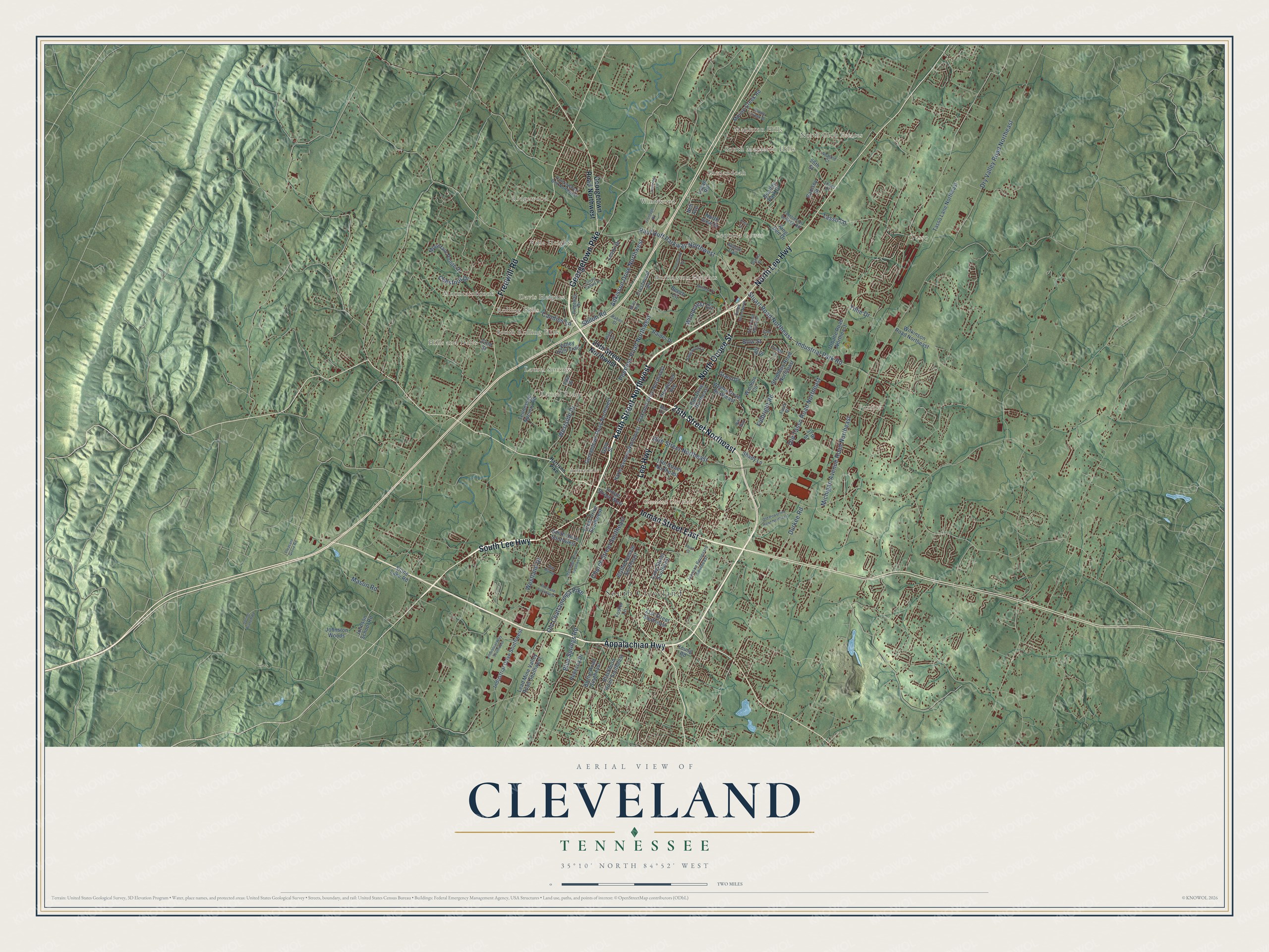
Cleveland, Tennessee Map Art
Building by building, with labeled streets and shaded relief.
12" x 18" Archival Matte Print
A Map of Home. A Work of Art.
Explore Cleveland, Tennessee from a whole new perspective. Created using aerial imagery and detailed geographic data, this map captures Cleveland building by building, with labeled streets, familiar landmarks, and shaded topographical relief that highlights the natural contours of the landscape.
Combining modern data with the timeless character of a vintage atlas, this map is just as interesting up close as it is beautiful on the wall. Whether you grew up in Cleveland, spent memorable years there, or call it home today, this unique map is a great way to celebrate a place that means something to you. Zoom in on the preview to look for your street, and then order a print to put your memories on the wall.
Three ways to hang it

Unframed archival matte, a black wood frame or a white wood frame.
Up close
Geography Worth Displaying
This map was created using accurate cartographic data and authoritative geographic sources, including the U.S. Geological Survey and the Census Bureau. The map brings together terrain, waterways, roads, and building detail. The majority of the streets are labeled, houses are accurately depicted, and the topography is derived from government sources. Combining local data with carefully composed color and shading leads to this beautifully detailed Cleveland artwork for your wall.
Rather than simply showing street outlines, we’ve included as many of the street names as we could reasonably fit on the map while keeping their names legible. Zoom in on the high resolution preview to see exactly what’s on the map. We truly set out to create a statement piece for anyone who loves Cleveland. So whether it’s for you, or a gift for someone you love, we hope this map of Cleveland brings back fond memories.
Read the story behind this map of Cleveland, Tennessee from 2026.

Find your street
Names on the Cleveland map
Every name below is printed on this map. Look for your street, your school, the park where you played, or the pond down the road.
Places and landmarks21
- Cleveland City Hall
- South Cleveland
- North Club Estates
- Ridgewood
- Foxfire
- Sequoia Grove
- South Rolling Hills
- South Mapleton Hills
- Tasso
- Burlington Heights
- Davis Heights
- Hills and Dales
Show all 21 places
- Laurel Ridge
- Windwood
- Villa Heights
- Shenandoah
- Mountainbrook
- Annadale
- Mapleton Hills
- Laurel Springs
- Rolling Hills
Streets and roads120
- Keith Street Northwest
- South Lee Highway
- Georgetown Pike
- 25th Street Northeast
- Lee Highway
- Inman Street East
- North Lee Highway
- North Ocoee Street
- Appalachian Highway
- Freewill Road
- Westside Drive
- Church Street Southeast
- Blue Springs Road
- Old Chattanooga Pike
- Michigan Avenue Road Northeast
- Peerless Road Northwest
- 20th Street Northeast
- Paul Huff Parkway Northwest
- Stuart Road Northeast
- Industrial Park Road
- Dry Valley Road Northeast
- Old Tasso Road Northeast
- Adkisson Drive Northwest
- Shiloh Road
- Chestnut Drive
- Westland Drive
- Candies Lane
- Woodcrest Circle
- Bow Street
- Fulbright Road
Show all 120 streets
- Mason Road
- Durkee Road
- Tasso Lane
- Tillie Drive
- 25th Street Northwest
- Georgetown Road Northwest
- Inman Street West
- 21st Street Southeast
- Mouse Creek Road
- Tasso Lane Northeast
- Weeks Drive Northeast
- Blythe Avenue Southeast
- Blackburn Road Southeast
- Industrial Drive Southwest
- Tennessee Nursery Road
- Harle Avenue Northwest
- Windsor Circle
- Oakland Drive Northwest
- Mountain Pointe Drive
- Crestwood Drive
- Henderson Avenue
- 15th Street Northeast
- Lenox Drive
- Lang Street Southeast
- Urbane Road Northeast
- Stephens Road Northeast
- Elm Drive Northeast
- Smith Drive Southwest
- Valley Hills Trail
- King Den Drive
- Blythe Road Southeast
- Lead Mine Valley Road Southwest
- 22nd Street
- Crest Drive Southwest
- Wilkinson Road Northeast
- 37th Street
- Johnson School Road
- Bentley Park Drive
- Shady Lane
- Johnston Woods
- Ramsey Street
- Raider Drive
- Foster Lane
- Rebecca Drive
- Grand Drive
- North View Drive
- Stone Lake Road
- Beech Circle
- 56th Street
- Gary Street
- Young Road
- Logan Road
- Jill Street
- Nell Avenue
- Johnson Boulevard Southeast
- Apache Trail
- Cottonwood Bnd Northwest
- Vista Drive
- Jones Drive
- Tomlinson College Road
- Ridgeway Drive
- Pike Drive
- Raben Drive
- Anatole Court
- Forest Lane
- Blair Road
- Faulk Drive
- Ben Drive
- Harrison Pike
- Crown Colony Drive
- Kile Lane Southwest
- Frontage Road
- Mimosa Drive
- Edgewood Circle
- Old Powerline Road Northeast
- Industrial Way Southwest
- Pryor Road Northeast
- Sun Hill Road
- Randolph Drive Southwest
- Forestview Drive
- Ocoee Street North
- Spring Branch Road
- Cree Lane
- Saddle Creek Drive
- Crestridge Lane
- Gale Drive
- Pleasant Grove Road
- Juanita Street
- Third Street
- Niki Way
Names are listed as they appear on the printed map. Zoom into the product photos to find them.
About Cleveland, Tennessee
Cleveland is a city of 47,356 people and the county seat of Bradley County. When the legislature created the county on February 10, 1836, it called for a county seat named for Colonel Benjamin Cleveland, who led troops at the Battle of Kings Mountain in the Revolution. The commissioners met on May 2, 1836, and picked Taylor's Place by a single vote, mostly because of its good water. Andrew Taylor, who had married a Cherokee woman, had built a log cabin there beside a spring.
The legislature made the choice official on January 20, 1838. That year the town had about 400 people, a Presbyterian church, a Methodist church and the Oak Grove Academy for boys. Cleveland was incorporated on February 4, 1842, and the railroad reached it on September 5, 1851. Julius Eckhardt Raht then ran the Copper Basin mines from Cleveland, where wagons brought in the copper and crews loaded it onto trains.
“To take and hold the railroad at or east of Cleveland, Tennessee, I think is as fully as important as the taking and holding of Richmond.”
- A Union town under occupationBradley County voted 1,382 to 507 against secession in June 1861. Residents raised a Union flag on the courthouse square in April 1861, and it flew until Confederate troops from Mississippi pulled it down in June 1862. Confederate forces held Cleveland from June 1861 until the fall of 1863, and Union troops had taken the town back by January 1864.
- Long's raid of 1863On November 25, 1863, while the Battle of Missionary Ridge raged in Chattanooga, Col. Eli Long rode into Cleveland with 1,500 Union cavalrymen. Over two days they tore up twelve miles of track and burned the Hiwassee railroad bridge for the second time. When about 500 Confederate cavalrymen attacked, Long's men fell back to Chattanooga.
- A blow to Confederate copperDuring the same raid, Long's men wrecked Raht's copper rolling mill, where Confederates had been making artillery shells and percussion caps. The loss hurt the whole Confederate army, which got about 90% of its copper from the Ducktown mines.
- Copper, stoves and chairsRaht had fled to Cincinnati during the war. He came back in 1866 and reopened the copper mines, which had turned out 24 million pounds of copper by 1878. Factories followed as Cleveland became one of the first Tennessee cities to industrialize. The Hardwick Stove Company opened in 1879, the Cleveland Woolen Mills came a year later in 1880, and the Cleveland Chair Company started in 1884.
Keep exploring Tennessee
Cleveland is one of 640 Tennessee towns we've mapped. Every dot on the map is a print of its own.
The search covers every state, Tennessee first.
Near Cleveland
Order 2 or more town maps and save 10%. Shown in the size and finish you picked above, so they hang as a set.
- East Cleveland 12" x 18" / Archival Matte Print $39.99
- Hopewell 12" x 18" / Archival Matte Print $39.99
- Prospect 12" x 18" / Archival Matte Print $39.99


More maps nearby: South Cleveland, Wildwood Lake, Taylor, McDonald and Ocoee.
The art of mapping a place
How This Map Was Made
Real places. Remarkable detail. Discover the layers that turn geographic data into a map of home.

The view from above
Aerial imagery reveals the character of the land: woodland, open fields, and the patterns of a place.

The shape of the land
Elevation data brings hills, valleys, and subtle changes in the landscape into view.

The details of home
Roads, waterways, and building footprints come together to make the map feel unmistakably local.

Geography becomes art
Considered color, shading, and typography bring the layers together in a map made for your wall.


Process illustrated with Mendon, Massachusetts. Aerial imagery: USDA NAIP. Terrain: USGS 3D Elevation Program. Map details and finished artwork: KNOWOL.
The Details
About This Print
Choose an archival matte print, or a black or white Ayous wood frame. The archival matte print is unframed.
Select your size and finish above to see the matching product image and price.
Materials & Craftsmanship
A contemporary map with the character of a classic atlas, printed on archival matte paper. Optional frames are made from Ayous wood.
Your printed map does not include the watermark shown in the full-map preview.
Shipping & Delivery
Free shipping within the United States. Every print is made to order in the USA.
Buying a gift? Add a note in your cart and we'll include it. We never put prices in the package.
Prints ship within 2 to 3 business days. Allow 7 to 10 days total from ordering for delivery. Timing may vary during holidays or periods of high order volume.
Read our shipping policy.
Returns and damaged prints
Each print is made to order. Change-of-mind refunds are not available after production.
If your print arrives damaged, misprinted or incorrect, contact support@knowol.com within 30 days of receiving it. Include your order number, photos and a description of the issue.
Read our full refund and replacement policy. For questions about your order, email support@knowol.com.