
Search for another town


Free U.S. delivery 7 to 10 days after you order
Destrehan, Louisiana Map Art
Building by building, with labeled streets and shaded relief.
12" x 18" Archival Matte Print
A Map of Home. A Work of Art.
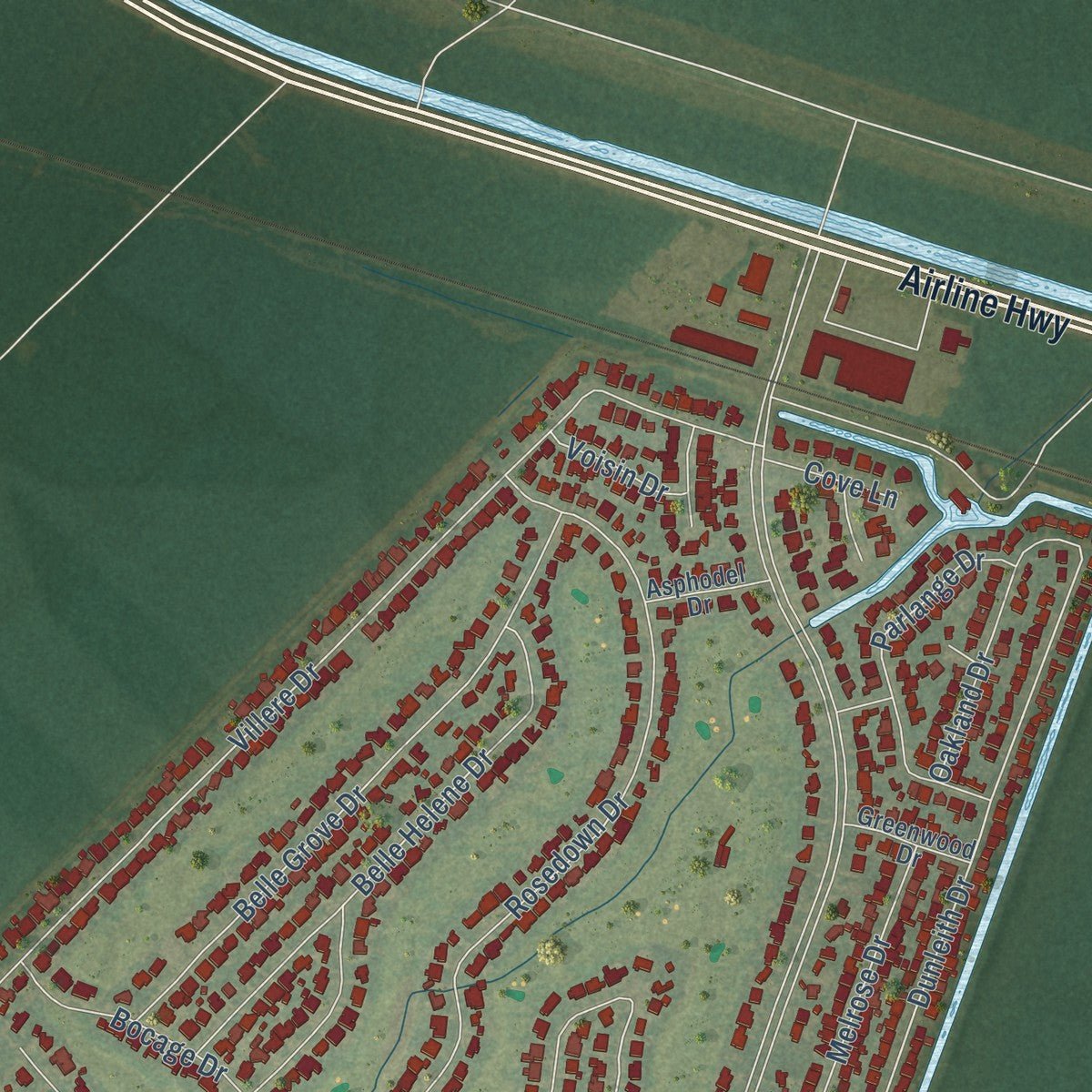
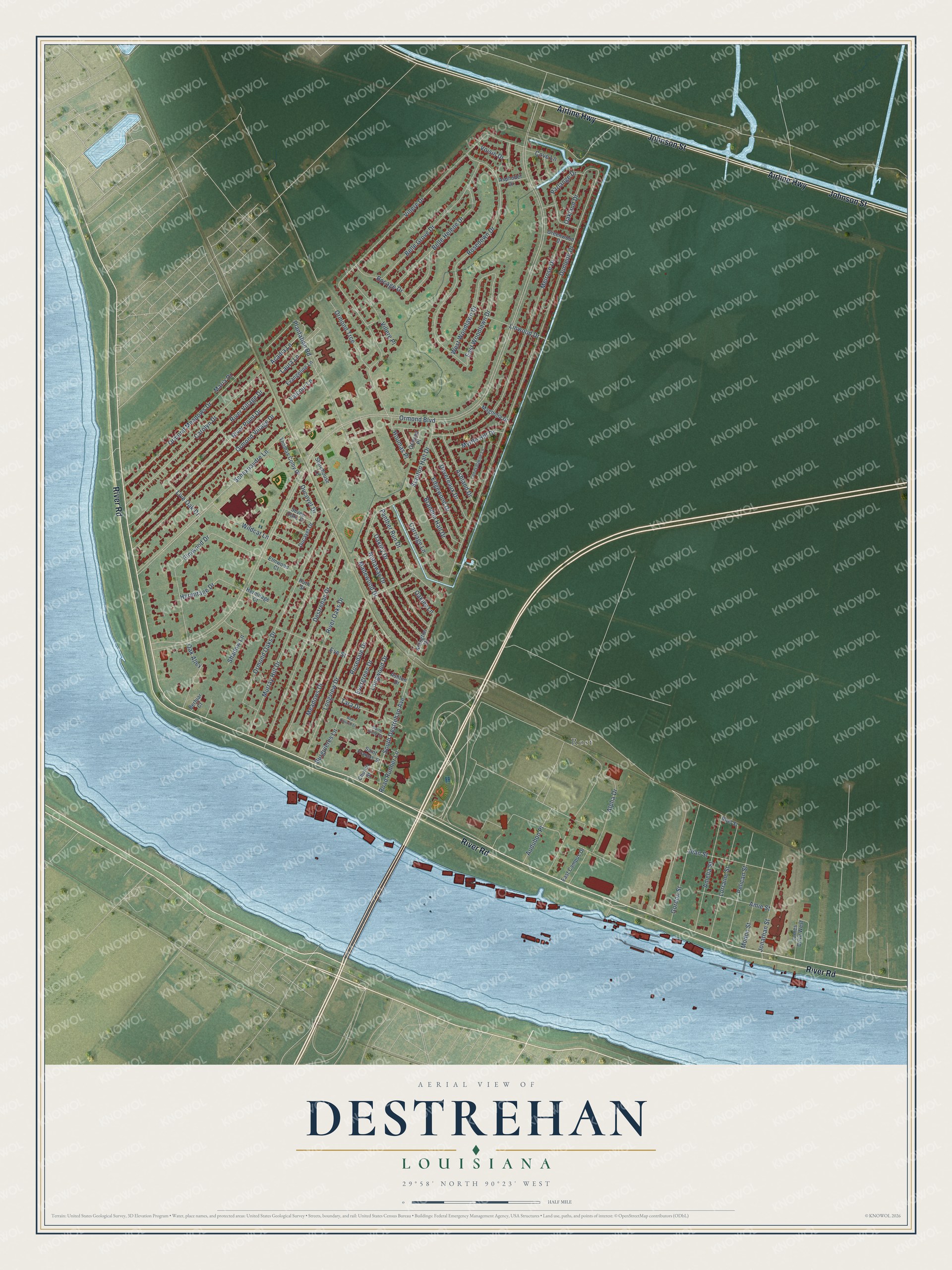
Explore Destrehan, Louisiana from a whole new perspective. Created using aerial imagery and detailed geographic data, this map captures Destrehan building by building, with labeled streets, familiar landmarks, and shaded topographical relief that highlights the natural contours of the landscape.
Combining modern data with the timeless character of a vintage atlas, this map is just as interesting up close as it is beautiful on the wall. Whether you grew up in Destrehan, spent memorable years there, or call it home today, this unique map is a great way to celebrate a place that means something to you. Zoom in on the preview to look for your street, and then order a print to put your memories on the wall.
Three ways to hang it

Unframed archival matte, a black wood frame or a white wood frame.
Up close
Geography Worth Displaying
This map was created using accurate cartographic data and authoritative geographic sources, including the U.S. Geological Survey and the Census Bureau. The map brings together terrain, waterways, roads, and building detail. The majority of the streets are labeled, houses are accurately depicted, and the topography is derived from government sources. Combining local data with carefully composed color and shading leads to this beautifully detailed Destrehan artwork for your wall.
Rather than simply showing street outlines, we’ve included as many of the street names as we could reasonably fit on the map while keeping their names legible. Zoom in on the high resolution preview to see exactly what’s on the map. We truly set out to create a statement piece for anyone who loves Destrehan. So whether it’s for you, or a gift for someone you love, we hope this map of Destrehan brings back fond memories.
Read the story behind this map of Destrehan, Louisiana from 2026.

Find your street
Names on the Destrehan map
Every name below is printed on this map. Look for your street, your school, the park where you played, or the pond down the road.
Places and landmarks1
- Rost
Streets and roads98
- River Road
- Johnson Street
- Airline Highway
- Madewood Drive
- Rosedale Drive
- Longwood Drive
- Oakley Drive
- Tara Drive
- Carriage Lane
- Dunleith Drive
- Stanton Hall Drive
- Live Oak Drive
- East Woodlawn Drive
- Ormond Boulevard
- Villere Drive
- Rosedown Drive
- Melrose Drive
- Murray Hill Drive
- Destrehan Drive
- Longview Drive
- Schexnaydre Lane
- Ormond Oaks Drive
- River Point Drive
- Ormond Village Drive
- Carolyn Drive
- Ormond Meadows Drive
- Elmwood Drive
- Nottaway Drive
- River Oaks Drive
- Belle Grove Drive
Show all 98 streets
- Plantation Road
- South Destrehan Avenue
- Belle Helene Drive
- River Village Drive
- Gordon Street
- Amelia Street
- Lorraine Street
- Bocage Drive
- Pelican Street
- Panther Run Drive
- Parlange Drive
- West Woodlawn Drive
- Jean Street
- Modoc Street
- Devereaux Drive
- Edgewood Drive
- Ormond Trce
- Alpha Drive
- Brandon Hall Drive
- Jonathan Street
- Meadows Drive
- Ashland Drive
- Eve Street
- Amie Street
- Acadia Lane
- Villere Place
- Hermitage Drive
- Oakland Drive
- Wildcat Lane
- Road Runner Lane
- Myrtle Hill Drive
- Shadow Lane
- Linwood Drive
- Burguieres Lane
- Evergreen Drive
- Ducoyet Drive
- Houmas Place
- Oakley Lane
- Audubon Place
- Laura Lane
- Valcour Lane
- Voisin Drive
- Cove Lane
- Oak Alley
- Maria Drive
- Ducayet Drive
- Arlington Drive
- Seven Oaks Court
- Noel Street
- James Drive West
- Ormond Place
- Thomas Colby Drive
- Evangeline Lane
- East Campus Drive
- Church Street
- Saint Francis Street
- Magnolia Drive
- Storehouse Lane
- Greenwood Drive
- Ashton Drive
- Asphodel Drive
- Elmwood Court
- Hermitage Court
- Berbiar Court
- Ruth Street
- Landsdowne Lane
- Saint Jude Street
- Red Church Lane
Names are listed as they appear on the printed map. Zoom into the product photos to find them.
About Destrehan, Louisiana
Destrehan is a community of 11,340 people in St. Charles Parish, on the east bank of the Mississippi River. It is named for Jean Noël Destréhan, who lived from 1754 to 1823 and owned the plantation at its center. He twice led the legislative council of the Orleans Territory, in 1806 and 1811. In 1812, the year Louisiana joined the Union as a state, he won a seat in the U.S. Senate, though he gave it up after a month. He then served in the Louisiana State Senate until 1817.
The plantation house came first. In January 1787 the indigo planter Robert Antoine Robin de Logny hired Charles, a free man of color who worked as a carpenter, woodworker and mason, to build it. The contract called for a house sixty feet long and thirty-five feet wide, set ten feet up on brick piers and wrapped in a gallery twelve feet deep. Charles built it with a pegged cypress frame, and it looked much like Homeplace, a house going up across the river at Hahnville.
“For payment, Charles received a slave, a cow and her calf, fifty quarts each of rice on chaff and corn in husks, and 100 piastres (units of currency).”
- The Destrehans arrive in 1792De Logny died in 1792, and in mid-December his daughter Marie Celeste and her husband, Jean-Noël Destrehan, took over the plantation. Like other planters of the time, they gave up indigo and grew sugarcane instead, and before his death in 1823 they added two-story wings to both sides of the house.
- The 1811 uprisingIn 1811, Charles Deslondes led between 150 and 500 enslaved people on a march from a plantation near present-day LaPlace toward Kenner, and several people enslaved at Destrehan joined them. More than one hundred were killed, and about seventy-five more were tried. One of those tribunals met at Destrehan, with Jean-Noël Destrehan sitting on it.
- Greek Revival in 1838In 1838 the plantation passed to Louise, a daughter of the Destrehans, and Pierre Rost, the man she had married, and they remade the house in the newest style. They wrapped the gallery posts in tall columns of plastered brick, closed in the rear gallery, moved the stairs to its center and joined the two middle rooms upstairs into a double parlor with pocket doors.
- Saved by its neighborsFor two years after the Civil War the house was a Freedmen's Bureau headquarters. It later belonged to the Mexican Petroleum Company from 1914 and to Amoco from 1958, and by then it was falling apart. Local people formed the River Road Historical Society, and Amoco gave it the house in 1971. Architect Eugene Cizek led the restoration, and Destrehan Plantation joined the National Register in 1973.
- A barn moved from GlendaleThe society has rescued old buildings from around the region by moving them to the Destrehan grounds. The largest is a raised mule barn of pegged timber, 162 feet by 35 feet, built in the 1830s at Glendale Plantation and rebuilt here. The restored plantation also served as a set for the 2013 film 12 Years a Slave.
Keep exploring Louisiana
Destrehan is one of 594 Louisiana towns we've mapped. Every dot on the map is a print of its own.
The search covers every state, Louisiana first.
Near Destrehan
Order 2 or more town maps and save 10%. Shown in the size and finish you picked above, so they hang as a set.
- New Sarpy 12" x 18" / Archival Matte Print $39.99
- St. Rose 12" x 18" / Archival Matte Print $39.99
- Norco 12" x 18" / Archival Matte Print $39.99


The art of mapping a place
How This Map Was Made
Real places. Remarkable detail. Discover the layers that turn geographic data into a map of home.

The view from above
Aerial imagery reveals the character of the land: woodland, open fields, and the patterns of a place.

The shape of the land
Elevation data brings hills, valleys, and subtle changes in the landscape into view.

The details of home
Roads, waterways, and building footprints come together to make the map feel unmistakably local.

Geography becomes art
Considered color, shading, and typography bring the layers together in a map made for your wall.


Process illustrated with Mendon, Massachusetts. Aerial imagery: USDA NAIP. Terrain: USGS 3D Elevation Program. Map details and finished artwork: KNOWOL.
The Details
About This Print
Choose an archival matte print, or a black or white Ayous wood frame. The archival matte print is unframed.
Select your size and finish above to see the matching product image and price.
Materials & Craftsmanship
A contemporary map with the character of a classic atlas, printed on archival matte paper. Optional frames are made from Ayous wood.
Your printed map does not include the watermark shown in the full-map preview.
Shipping & Delivery
Free shipping within the United States. Every print is made to order in the USA.
Buying a gift? Add a note in your cart and we'll include it. We never put prices in the package.
Prints ship within 2 to 3 business days. Allow 7 to 10 days total from ordering for delivery. Timing may vary during holidays or periods of high order volume.
Read our shipping policy.
Returns and damaged prints
Each print is made to order. Change-of-mind refunds are not available after production.
If your print arrives damaged, misprinted or incorrect, contact support@knowol.com within 30 days of receiving it. Include your order number, photos and a description of the issue.
Read our full refund and replacement policy. For questions about your order, email support@knowol.com.