
Search for another town


Free U.S. delivery 7 to 10 days after you order
Easton, Maryland Map Art
Building by building, with labeled streets and shaded relief.
12" x 18" Archival Matte Print
A Map of Home. A Work of Art.
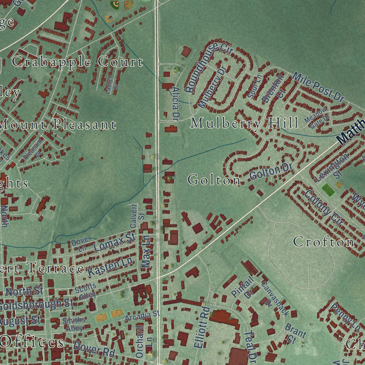
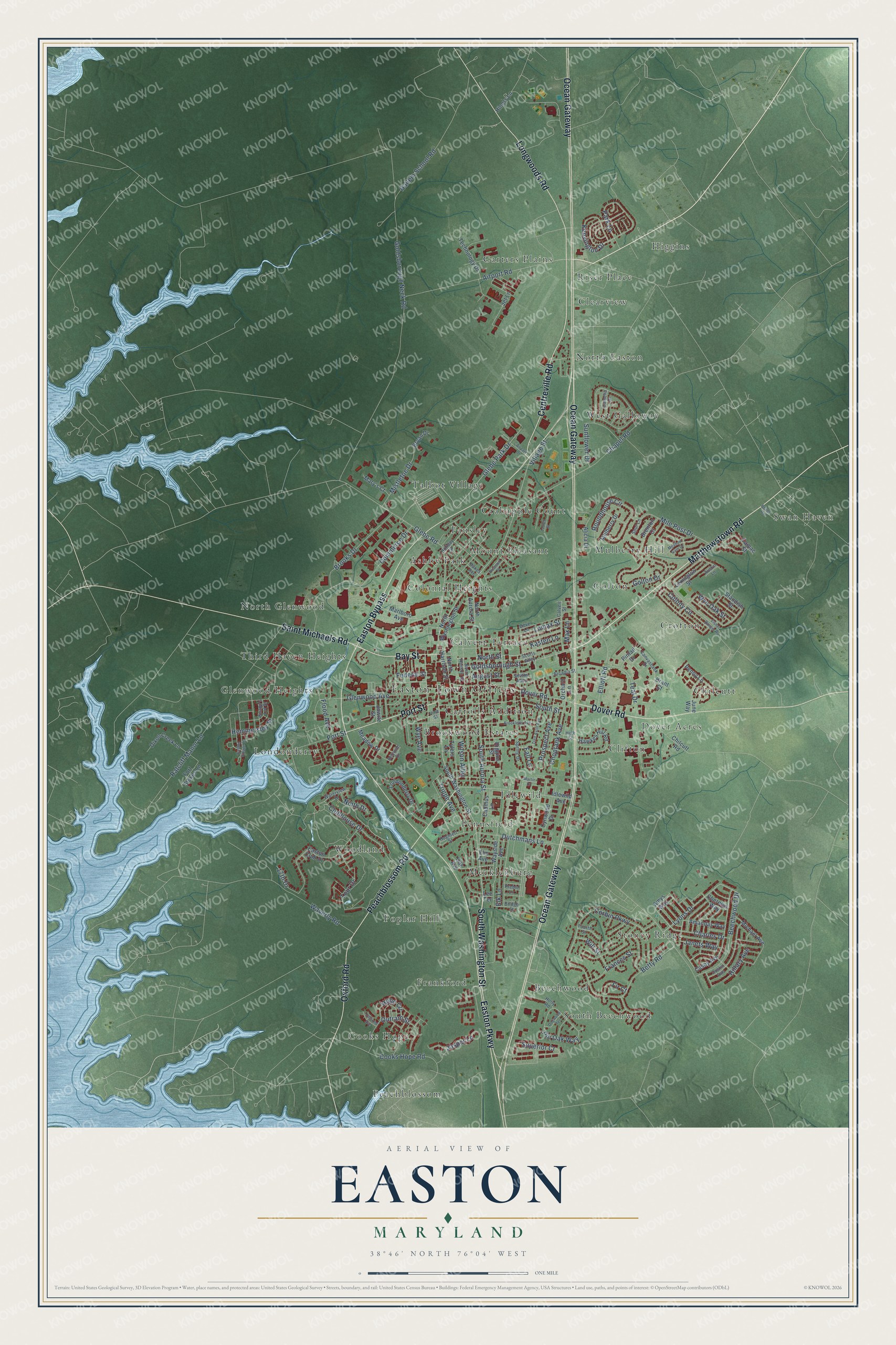
Explore Easton, Maryland from a whole new perspective. Created using aerial imagery and detailed geographic data, this map captures Easton building by building, with labeled streets, familiar landmarks, and shaded topographical relief that highlights the natural contours of the landscape.
Combining modern data with the timeless character of a vintage atlas, this map is just as interesting up close as it is beautiful on the wall. Whether you grew up in Easton, spent memorable years there, or call it home today, this unique map is a great way to celebrate a place that means something to you. Zoom in on the preview to look for your street, and then order a print to put your memories on the wall.
Three ways to hang it
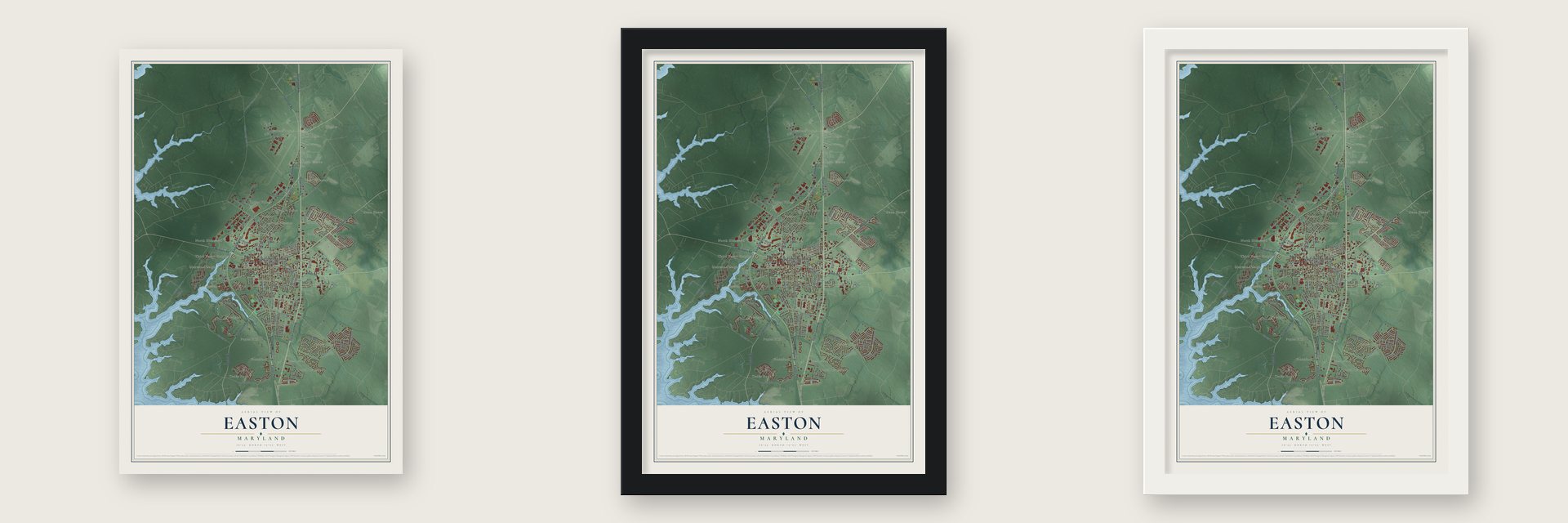
Unframed archival matte, a black wood frame or a white wood frame.
Up close
Geography Worth Displaying
This map was created using accurate cartographic data and authoritative geographic sources, including the U.S. Geological Survey and the Census Bureau. The map brings together terrain, waterways, roads, and building detail. The majority of the streets are labeled, houses are accurately depicted, and the topography is derived from government sources. Combining local data with carefully composed color and shading leads to this beautifully detailed Easton artwork for your wall.
Rather than simply showing street outlines, we’ve included as many of the street names as we could reasonably fit on the map while keeping their names legible. Zoom in on the high resolution preview to see exactly what’s on the map. We truly set out to create a statement piece for anyone who loves Easton. So whether it’s for you, or a gift for someone you love, we hope this map of Easton brings back fond memories.
Read the story behind this map of Easton, Maryland from 2026.

Find your street
Names on the Easton map
Every name below is printed on this map. Look for your street, your school, the park where you played, or the pond down the road.
Places and landmarks38
- Easton Town Offices
- Ashby Park
- Beechwood
- Brookwood Estates
- Calvert Terrace
- Carrolls Addition
- Carters Plains
- Chilcutt
- Clearview
- Clifton
- Colonial Heights
- Cooks Hope
Show all 38 places
- Crabapple Court
- Crofton
- Dover Acres
- Fausley
- Frankford
- Glenwood Heights
- Golton
- Higgins
- Idlewild
- Londonderry
- Mecklenburg
- Mount Pleasant
- Mulberry Hill
- North Easton
- North Glenwood
- Peachblossom
- Pennsfield
- Poplar Hill
- Riser Place
- South Beechwood
- Stoney Ridge
- Swan Haven
- Talbot Village
- Third Haven Heights
- West Galloway
- Woodland
Streets and roads153
- South Washington Street
- Matthewstown Road
- Centreville Road
- Ocean Gateway
- Easton Bypass
- Peachblossom Road
- Oxford Road
- Easton Parkway
- Dover Road
- Longwoods Road
- Port Street
- Bay Street
- Saint Michaels Road
- Charles Drive
- North Street
- Glebe Park Drive
- Goldsborough Street
- Airport Road
- Wye Avenue
- Lyons Drive
- Betty Road
- Park Lane
- Dutchmans Lane
- Corbin Parkway
- Glebe Road
- Goldsborough Neck Road
- Ratcliff Manor Lane
- Chapel Road
- South Aurora Street
- Beechwood Drive
Show all 153 streets
- Colony Circle
- Cooks Hope Road
- South Street
- Roundhouse Circle
- Golton Drive
- Glenwood Avenue
- Superior Cr
- Pin Oak Way
- Brooks Drive
- Clubhouse Drive
- Tour Drive
- Waverly Road
- Hailem School Road
- Village Street
- Commerce Drive
- Elliott Road
- Mile Post Drive
- Choptank Avenue
- Elk Lane
- Prospect Avenue
- Teal Drive
- Mistletoe Drive
- Frances Street
- Outram Street
- Hillary Avenue
- Hemmersley Street
- Lomax Street
- Kensington Drive
- August Street
- Trippe Avenue
- Jasper Lane
- Flood Avenue
- Hope Circle
- Wilson Alley
- Will Street
- Sunflower Drive
- Wye Oak Street
- Janets Way
- Federal Street
- Kasten Lane
- Fir Court
- 17th Drive
- Ninth Drive
- Max Lane
- Fall Lane
- North Washington Street
- Amys Way
- Marlboro Avenue
- Easton Club Drive
- Idlewild Avenue
- North Aurora Street
- Standish Street
- Londonderry Drive
- Casey Avenue
- Dixon Creek Lane
- Hawkes Hill Road
- Wayside Avenue
- Oak Avenue
- Mulberry Drive
- Michael Avenue
- Technology Drive
- Alicia Drive
- Cadmus Lane
- North Harrison Street
- Lexington Street
- Penny Lane
- Jet Lane
- Amandas Way
- Fort Stokes Lane
- Higgins Street
- Brenton Court
- June Way
- Chilcutt Road
- Mary's Court
- Tylers Lane
- Cynwood Drive
- Meadow Drive
- Orchard Lane
- Camac Street
- Cherelyn Way
- Jowite Street
- Hiners Lane
- Elm Avenue
- Bryan Drive
- Pintail Drive
- Brant Court
- Lee Terrace
- Dustin Avenue
- Scotts Alley
- Canvasback Drive
- Holiday Street
- Calvert Street
- Dove Lane
- Knapp's Lot Street
- High Street
- Holly Road
- Bethune Drive
- Spring Drive
- Camelia Drive
- Hughlett Street
- Spur Lane
- North Hanson Street
- Vine Street
- Waterview Drive
- Arcadia Street
- Fourth Street
- Smiths Alley
- Bridge Street
- Preble Lane
- Austin Lane
- Dukes Avenue
- Meadow Gate Drive
- Easton Village Drive
- Brookletts Avenue
- Fisher Ranger Road
- Laurel Street
- Tred Avon Avenue
- Airpark Drive
- Dogwood Terrace
- Martin Court
- Beans Road
- Edmond Avenue
- Pleasant Place
Names are listed as they appear on the printed map. Zoom into the product photos to find them.
About Easton, Maryland
Easton is a town of 17,101 people and the seat of Talbot County, on Maryland's Eastern Shore. Talbot's court first gathered at York, close to where Skipton Creek empties out, but people in other parts of the county found it hard to reach. So on November 4, 1710, the Assembly of the Province of Maryland passed an act to build a new courthouse at Armstrong's Old Field, near Pitt's Bridge at the head of the Tred Avon River.
Two acres were bought from Philemon Armstrong for 15,000 pounds of tobacco, and a brick courthouse, 20 by 30 feet, went up on the ground where today's courthouse stands. It cost 115,000 pounds of tobacco, and court sat there from 1712 until 1794. A tavern for people coming to court was among the first buildings, then stores and homes followed, and the village took the name Talbot Court House. By 1810 Easton was the largest town on the Eastern Shore.
“In 1778 the Maryland legislature authorized the building of the Talbot County Courthouse at Dover, but the act seems to have been disregarded and the county seat was placed at Talbot, now Easton.”
- The Hill, by 1790The 1790 census found 410 free people of color living in Easton's Hill neighborhood. Scholars believe the Hill may be the oldest community of free African Americans in the United States, and the oldest Black neighborhood still standing.
- Its first mayor, 1906A new charter in 1906 ended the town commissioner system Easton had used since 1791 and created a mayor and council. Voters chose Martin M. Higgins as the first mayor, and he served from 1906 to 1908 and again from 1910 to 1914. His programs brought paved streets, concrete gutters and sidewalks, and water, sewer, gas and electric systems run by the town.
- Town-owned power since 1915In 1914 Easton became the first Maryland town with a complete sewer system. A year later it opened its own electric plant, replacing a private company that since 1888 had supplied power only from dusk to midnight, and it was one of the first plants in the world to use alternating current. By 1923 Easton owned all of its utilities, the first community in Maryland to do so.
- A hospital in 1907Mary Bartlett Dixon, a nurse and suffragist, and Elizabeth Wright led the effort that opened Easton Emergency Hospital, the town's first, in 1907. Dixon started it in a rented building that later burned, and the two women began a nursing school run by volunteers.
- Baker and Foxx played hereEaston teams, among them the Easton Yankees, played in the Class D Eastern Shore League between 1924 and 1949. Home Run Baker and Jimmie Foxx, both members of the Baseball Hall of Fame, wore Easton uniforms.
Keep exploring Maryland
Easton is one of 881 Maryland towns we've mapped. Every dot on the map is a print of its own.
The search covers every state, Maryland first.
Near Easton
Order 2 or more town maps and save 10%. Shown in the size and finish you picked above, so they hang as a set.
- Cordova 12" x 18" / Archival Matte Print $39.99
- Trappe 12" x 18" / Archival Matte Print $39.99
- Oxford 12" x 18" / Archival Matte Print $39.99


More maps nearby: St. Michaels, Choptank, Preston, Queen Anne and Hillsboro.
The art of mapping a place
How This Map Was Made
Real places. Remarkable detail. Discover the layers that turn geographic data into a map of home.

The view from above
Aerial imagery reveals the character of the land: woodland, open fields, and the patterns of a place.

The shape of the land
Elevation data brings hills, valleys, and subtle changes in the landscape into view.

The details of home
Roads, waterways, and building footprints come together to make the map feel unmistakably local.

Geography becomes art
Considered color, shading, and typography bring the layers together in a map made for your wall.


Process illustrated with Mendon, Massachusetts. Aerial imagery: USDA NAIP. Terrain: USGS 3D Elevation Program. Map details and finished artwork: KNOWOL.
The Details
About This Print
Choose an archival matte print, or a black or white Ayous wood frame. The archival matte print is unframed.
Select your size and finish above to see the matching product image and price.
Materials & Craftsmanship
A contemporary map with the character of a classic atlas, printed on archival matte paper. Optional frames are made from Ayous wood.
Your printed map does not include the watermark shown in the full-map preview.
Shipping & Delivery
Free shipping within the United States. Every print is made to order in the USA.
Buying a gift? Add a note in your cart and we'll include it. We never put prices in the package.
Prints ship within 2 to 3 business days. Allow 7 to 10 days total from ordering for delivery. Timing may vary during holidays or periods of high order volume.
Read our shipping policy.
Returns and damaged prints
Each print is made to order. Change-of-mind refunds are not available after production.
If your print arrives damaged, misprinted or incorrect, contact support@knowol.com within 30 days of receiving it. Include your order number, photos and a description of the issue.
Read our full refund and replacement policy. For questions about your order, email support@knowol.com.