
Search for another town


Free U.S. delivery 7 to 10 days after you order
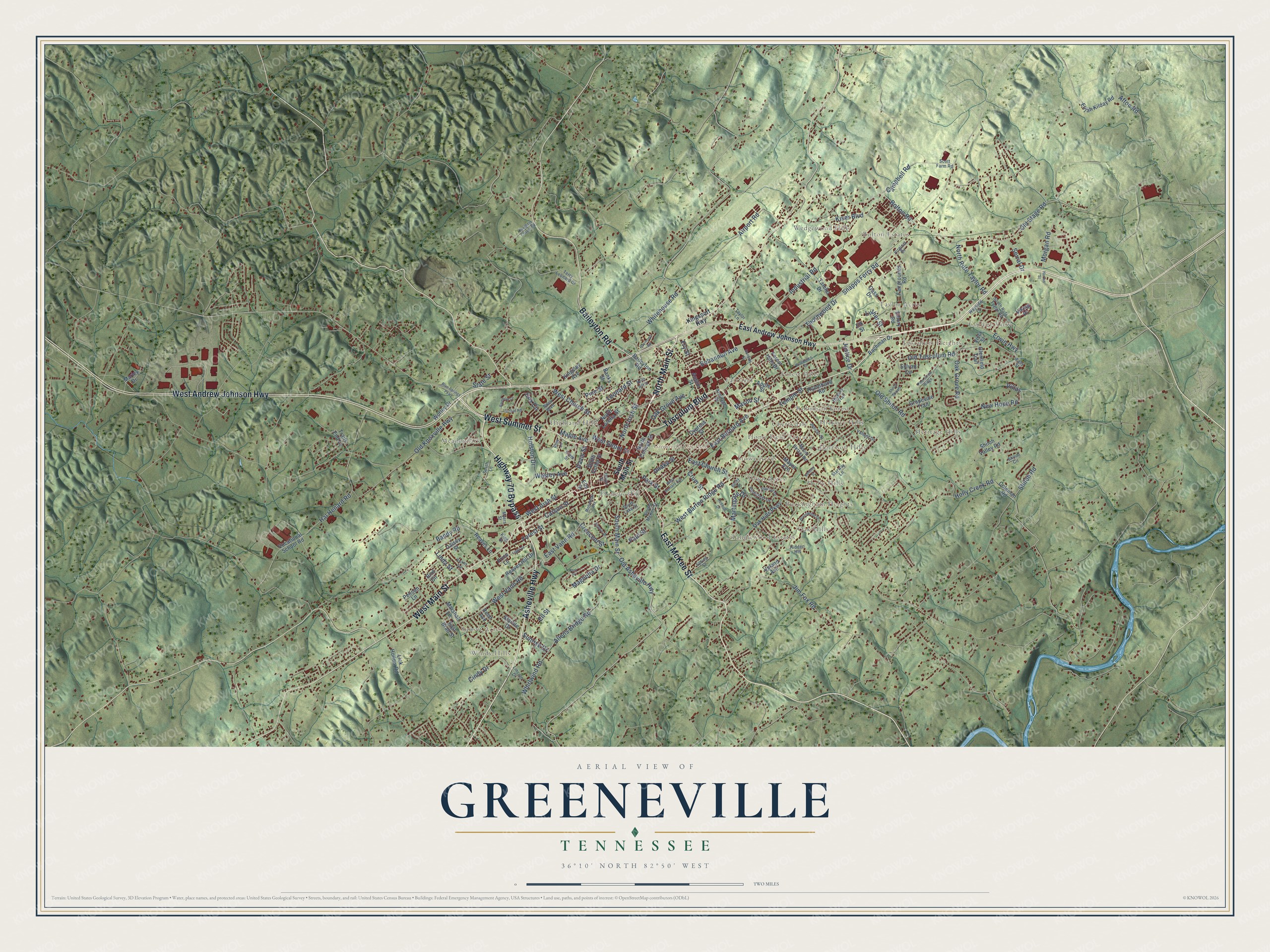
Greeneville, Tennessee Map Art
Building by building, with labeled streets and shaded relief.
12" x 18" Archival Matte Print
A Map of Home. A Work of Art.
Explore Greeneville, Tennessee from a whole new perspective. Created using aerial imagery and detailed geographic data, this map captures Greeneville building by building, with labeled streets, familiar landmarks, and shaded topographical relief that highlights the natural contours of the landscape.
Combining modern data with the timeless character of a vintage atlas, this map is just as interesting up close as it is beautiful on the wall. Whether you grew up in Greeneville, spent memorable years there, or call it home today, this unique map is a great way to celebrate a place that means something to you. Zoom in on the preview to look for your street, and then order a print to put your memories on the wall.
Three ways to hang it

Unframed archival matte, a black wood frame or a white wood frame.
Up close
Geography Worth Displaying
This map was created using accurate cartographic data and authoritative geographic sources, including the U.S. Geological Survey and the Census Bureau. The map brings together terrain, waterways, roads, and building detail. The majority of the streets are labeled, houses are accurately depicted, and the topography is derived from government sources. Combining local data with carefully composed color and shading leads to this beautifully detailed Greeneville artwork for your wall.
Rather than simply showing street outlines, we’ve included as many of the street names as we could reasonably fit on the map while keeping their names legible. Zoom in on the high resolution preview to see exactly what’s on the map. We truly set out to create a statement piece for anyone who loves Greeneville. So whether it’s for you, or a gift for someone you love, we hope this map of Greeneville brings back fond memories.
Read the story behind this map of Greeneville, Tennessee from 2026.

Find your street
Names on the Greeneville map
Every name below is printed on this map. Look for your street, your school, the park where you played, or the pond down the road.
Places and landmarks25
- Greeneville City Hall
- Bolton Estates
- Windy Hills
- Heritage Hills
- Meadowlark
- Fairfield
- Buckingham Heights
- Tusculum Heights
- Tanglewood Estates
- Honeys Hill
- Harrison Hills
- College View
Show all 25 places
- Forest Hills
- Wedgewood Hills
- Highland Hills
- Home Field Terrace
- Stowe Acres
- Taylor Acres
- Oak Hills
- Robinson Forest
- Holly Hills
- Sunset Acres
- Cherrydale
- Town Acres
- Hickory Hills
Streets and roads169
- Asheville Highway
- North Main Street
- Highway 70 Bypass
- East McKee Street
- West Summer Street
- Tusculum Boulevard
- West Main Street
- West Andrew Johnson Highway
- Baileyton Road
- South Main Street
- Old Asheville Highway
- Old Stage Road
- Campbell Road
- Snapps Ferry Road
- Old Shiloh Road
- East Church Street
- Hal Henard Road
- Old Tusculum Road
- Allens Bridge Road
- Whirlwind Road
- Industrial Road
- West Irish Street
- Airport Road
- Old Knoxville Highway
- Bohannon Avenue
- West Church Street
- Forest Street
- West Vann Road
- Whitehouse Road
- Holly Creek Road
Show all 169 streets
- West Barton Ridge Road
- North Irish Street
- Magnolia Drive
- Wesley Avenue
- East Vann Road
- Kiser Boulevard
- Carson Street
- Jim Fox Road
- East Bernard Avenue
- Erwin Highway
- Leonard Street
- Afton Road
- Oak Grove Road
- Martingale Drive
- New Hope Road
- North Rufe Taylor Road
- Park Street
- Oak Grove Avenue
- Thornwood Drive
- Unaka Street
- Holston Drive
- Cox Circle
- West Depot Street
- Bandy Road
- Morgan Road
- Crescent Street
- Bolton Road
- Ell Street
- Temple Street
- Linda Street
- Shiloh Road
- Cindy Drive
- Maple Avenue
- Serral Drive
- Mason Street
- Sunrise Drive
- Crum Street
- Luther Street
- Davis Street
- Justice Drive
- State Street
- Pine Street
- Paul Street
- Fry Street
- Villas
- East Andrew Johnson Highway
- Marshall Lane
- Pelican Lane
- Vocational School Road
- Grapevine Trail
- Fairgrounds Road
- Coleman Road
- Upland Avenue
- Mayor Avenue
- Oak Hills Parkway
- Forest Hills Drive
- Reed Avenue
- Elijah Kilday Road
- Apple Street
- Bird Circle
- Bachman Drive
- Reaves Hill Drive
- Cypress Street
- Viking Place
- Sylvan Circle
- Gass Drive
- Tateho Drive
- Shiloh Valley Road
- South Cutler Street
- North Loretta Street
- Lick Hollow Road
- Starlite Drive
- North College Street
- Daisey Street
- Austin Street
- Robinhood Road
- Glenfield Trail
- Reaves Lane
- Worley Drive
- Kingsley Avenue
- East Brad Street
- Marley Drive
- Emory Road
- Vista Street
- Banks Street
- Trails End Lane
- Price Lane
- Elk Street
- Elm Street
- Kingsport Highway
- Jenifer Street
- Mount Bethel Road
- Terry Leonard Drive
- South McKee Street
- Valiant Drive
- South Rufe Taylor Road
- Hidden Heights
- South Lake Street
- Armitage Drive
- Pinecrest Drive
- Ross Boulevard
- Hickory Trail
- Myers Street
- Lincoln Drive
- Spring Street
- Starway Lane
- Virginia Drive
- Wayside Lane
- Smith Lane
- Clem Street
- Scott Farm Road
- Taylor Lane
- Shiloh Circle
- Easy Street
- Union Street
- King Street
- Blue Springs Parkway
- Brentwood Drive
- Arnold Road
- West Bernard Avenue
- Kenney Street
- Redbud Drive
- Doughtys Chapel Road
- North Hill Street
- Pine Straw Ridge
- Shiloh Shoals
- Woodlawn Drive
- Ricker Avenue
- Monument Avenue
- Rhea Circle
- Rainbow Lane
- Raymond Road
- Park Place
- Wayfair Drive
- Harlan Street
- Hankins Street
- Becky Drive
- Scenic Drive
- Light Street
Names are listed as they appear on the printed map. Zoom into the product photos to find them.
About Greeneville, Tennessee
Greeneville is a town of 15,479 people and the seat of Greene County, in the valley of the Nolichucky River. Permanent settlement began in 1772, when Jacob Brown, a North Carolina merchant, leased land from the Cherokee. Settler Daniel Kennedy pushed for a county of their own, which was granted in 1783 and named for the Revolutionary War hero Nathanael Greene. Robert Kerr, who lived at Big Spring, gave 50 acres for the county seat, and Greeneville became a town in 1786.
In 1784 North Carolina tried to pay its debts by handing its western lands to Congress. Delegates from Greene and nearby counties answered by planning a new state called Franklin, after Benjamin Franklin. Greeneville was chosen as its capital in August 1785. That December the first Franklin legislature met there in a rough log courthouse and approved a constitution much like North Carolina's. Congress never admitted the state, and North Carolina took the area back the next spring.
- A tailor who became presidentAndrew Johnson came to Greeneville in 1826 after running away from an apprenticeship in Raleigh. The local tailor was about to retire, so Johnson bought his shop. A public debate with Blackstone McDannel over Indian Removal led the two men to start a debate society. That gave Johnson the skills to win a council seat in 1829 and the mayor's office in 1834. He later became the 17th President of the United States.
- An antislavery press in 1822Quakers from Pennsylvania helped build a strong abolitionist movement in Greene County. After Elihu Embree died in 1820, Benjamin Lundy bought his printing press and moved to Greeneville in 1822, where he printed The Genius of Universal Emancipation. He stayed two years before leaving for Baltimore, and in 1829 he hired William Lloyd Garrison. Hezekiah Balch had freed his own slaves at the county courthouse in 1807.
- Unionists and ConfederatesIn June 1861, delegates from thirty counties met in Greeneville as the East Tennessee Convention and asked to form a separate state loyal to the Union. Nashville refused, and Confederate troops soon took over the region. Part of James Longstreet's army spent the winter here after the failed Siege of Knoxville in 1863. On September 4, 1864, Union soldiers under Alvan Cullem Gillem raided the town, and Confederate general John Hunt Morgan was killed.
- Pet Milk arrives in 1928Burley tobacco and dairy farming drove growth in Greene County, and dairying grew more important after Pet Milk built a plant in Greeneville in 1928. The town was also a busy stop on the Southern Railway, and a group of late Victorian commercial buildings from those years still lines its streets.
Keep exploring Tennessee
Greeneville is one of 640 Tennessee towns we've mapped. Every dot on the map is a print of its own.
The search covers every state, Tennessee first.
Near Greeneville
Order 2 or more town maps and save 10%. Shown in the size and finish you picked above, so they hang as a set.
- Tusculum 12" x 18" / Archival Matte Print $39.99
- Mosheim 12" x 18" / Archival Matte Print $39.99
- Chuckey 12" x 18" / Archival Matte Print $39.99


More maps nearby: Camp Creek, Baileyton, Bulls Gap, Telford and Sulphur Springs.
The art of mapping a place
How This Map Was Made
Real places. Remarkable detail. Discover the layers that turn geographic data into a map of home.

The view from above
Aerial imagery reveals the character of the land: woodland, open fields, and the patterns of a place.

The shape of the land
Elevation data brings hills, valleys, and subtle changes in the landscape into view.

The details of home
Roads, waterways, and building footprints come together to make the map feel unmistakably local.

Geography becomes art
Considered color, shading, and typography bring the layers together in a map made for your wall.


Process illustrated with Mendon, Massachusetts. Aerial imagery: USDA NAIP. Terrain: USGS 3D Elevation Program. Map details and finished artwork: KNOWOL.
The Details
About This Print
Choose an archival matte print, or a black or white Ayous wood frame. The archival matte print is unframed.
Select your size and finish above to see the matching product image and price.
Materials & Craftsmanship
A contemporary map with the character of a classic atlas, printed on archival matte paper. Optional frames are made from Ayous wood.
Your printed map does not include the watermark shown in the full-map preview.
Shipping & Delivery
Free shipping within the United States. Every print is made to order in the USA.
Buying a gift? Add a note in your cart and we'll include it. We never put prices in the package.
Prints ship within 2 to 3 business days. Allow 7 to 10 days total from ordering for delivery. Timing may vary during holidays or periods of high order volume.
Read our shipping policy.
Returns and damaged prints
Each print is made to order. Change-of-mind refunds are not available after production.
If your print arrives damaged, misprinted or incorrect, contact support@knowol.com within 30 days of receiving it. Include your order number, photos and a description of the issue.
Read our full refund and replacement policy. For questions about your order, email support@knowol.com.