
Search for another town


Free U.S. delivery 7 to 10 days after you order
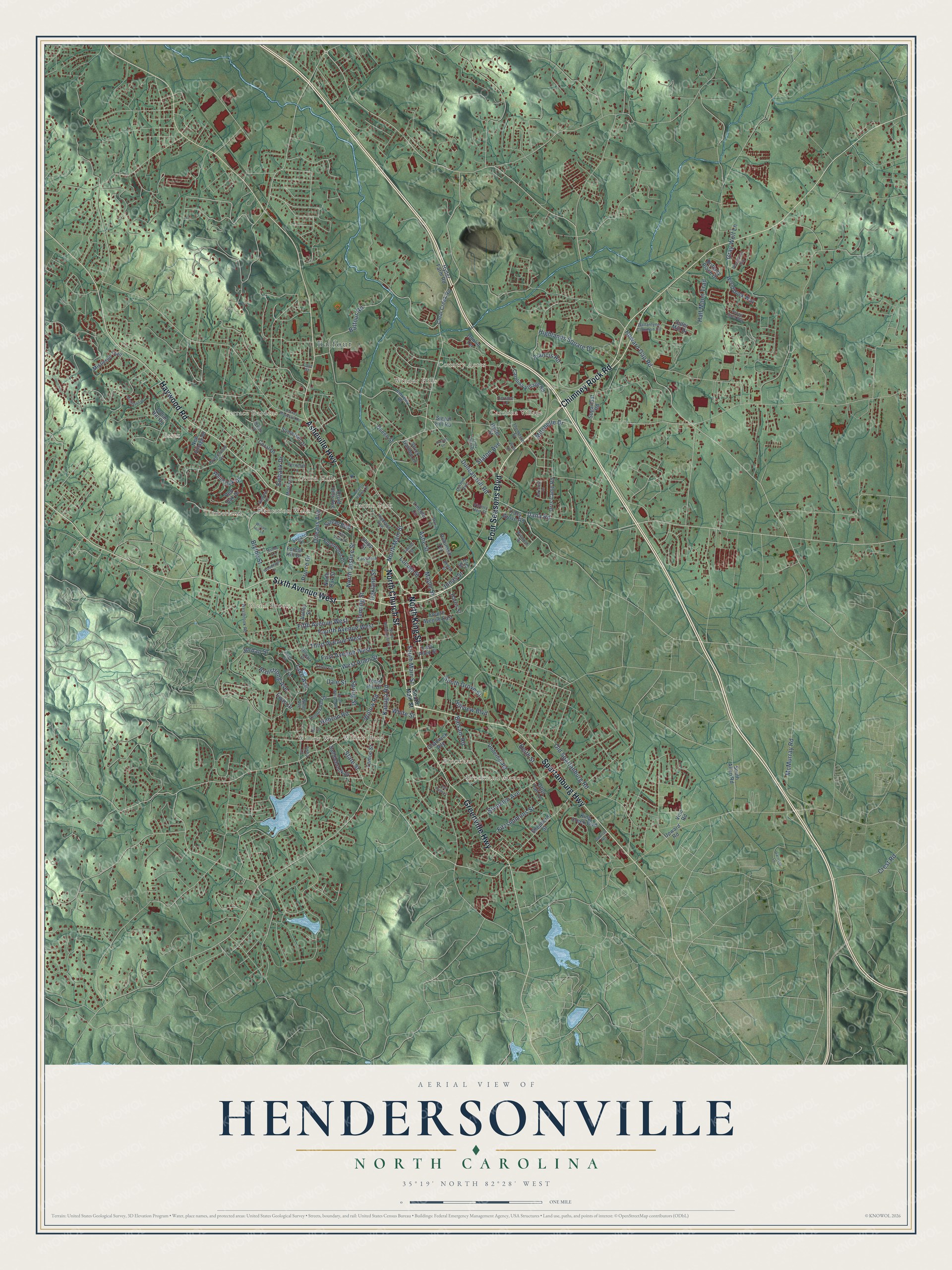
Hendersonville, North Carolina Map Art
Building by building, with labeled streets and shaded relief.
12" x 18" Archival Matte Print
A Map of Home. A Work of Art.
Explore Hendersonville, North Carolina from a whole new perspective. Created using aerial imagery and detailed geographic data, this map captures Hendersonville building by building, with labeled streets, familiar landmarks, and shaded topographical relief that highlights the natural contours of the landscape.
Combining modern data with the timeless character of a vintage atlas, this map is just as interesting up close as it is beautiful on the wall. Whether you grew up in Hendersonville, spent memorable years there, or call it home today, this unique map is a great way to celebrate a place that means something to you. Zoom in on the preview to look for your street, and then order a print to put your memories on the wall.
Three ways to hang it

Unframed archival matte, a black wood frame or a white wood frame.
Up close
Geography Worth Displaying
This map was created using accurate cartographic data and authoritative geographic sources, including the U.S. Geological Survey and the Census Bureau. The map brings together terrain, waterways, roads, and building detail. The majority of the streets are labeled, houses are accurately depicted, and the topography is derived from government sources. Combining local data with carefully composed color and shading leads to this beautifully detailed Hendersonville artwork for your wall.
Rather than simply showing street outlines, we’ve included as many of the street names as we could reasonably fit on the map while keeping their names legible. Zoom in on the high resolution preview to see exactly what’s on the map. We truly set out to create a statement piece for anyone who loves Hendersonville. So whether it’s for you, or a gift for someone you love, we hope this map of Hendersonville brings back fond memories.
Read the story behind this map of Hendersonville, North Carolina from 2026.

Find your street
Names on the Hendersonville map
Every name below is printed on this map. Look for your street, your school, the park where you played, or the pond down the road.
Places and landmarks15
- Balfour
- Willow Wew
- Essex
- Carolina Village
- Brookland Manor
- Patton Park
- Glenn Brook
- Terrace Gardens
- Timberland
- Plantation Walk
- Windor Hills
- Country Acres
Show all 15 places
- Willow Bend
- Druid Hills
- Brookdale
Streets and roads148
- Four Seasons Boulevard
- Spartanburg Highway
- North Church Street
- Sixth Avenue West
- Chimney Rock Road
- Haywood Road
- Asheville Highway
- Greenville Highway
- North King Street
- North Main Street
- Balfour Road
- Dana Road
- South Main Street
- Howard Gap Road
- Kanuga Road
- Willow Road
- Blythe Street
- Fifth Avenue West
- Old Spartanburg Road
- Fourth Avenue West
- North Justice Street
- Third Avenue West
- Half Moon Trail
- Hebron Road
- Balsam Road
- South Grove Street
- West Allen Street
- Brooklyn Avenue
- Oakland Street
- Fleming Street
Show all 148 streets
- Duncan Hill Road
- Gray Wolf Lane
- Highlands Square Drive
- First Avenue West
- Maple Street
- Orleans Avenue
- Ashe Street
- Francis Road
- State Street
- Lake Avenue
- McMurray Road
- Armstrong Avenue
- Spring Street
- Jordan Street
- Fitzsimmons Street
- Locust Street
- Crest Road
- Hillview Boulevard
- White Street
- Mitchelle Drive
- Ewbank Drive
- Staton Avenue
- Prince Drive
- Keith Street
- Jonas Street
- Dale Street
- Clear Creek Road
- Forest Hill Drive
- Tracy Grove Road
- White Oak Drive
- Carolina Village Road
- Sylvan Boulevard
- North Oak Street
- Chadwick Avenue
- Sugarloaf Road
- Wood Duck Way
- Fourth Avenue East
- Valley Street
- Shepherd Street
- Mistletoe Trail
- King Creek Boulevard
- Signal Hill Road
- Orrs Camp Road
- Underhill Road
- Temon Street
- Lincoln Circle
- Red Oak Drive
- Saddlebrook Drive
- Upward Road
- Brittany Place Drive
- Druid Hills Avenue
- Toms Hill Drive
- Knollwood Drive
- Dunlin Terrace
- Hyder Farm Road
- Indian Hill Road
- Ewart Drive
- East Allen Street
- Hyder Street
- New Village Drive
- Somerset Drive
- Cider Mill Drive
- Strick Garden Lane
- Robinson Terrace
- Queen Street
- Coral Drive
- Harris Street
- South Allen Road
- Shipp Street
- Otter Tail Lane
- Elm Street
- Vine Road
- Thompson Street
- Berkeley Road
- Lugano Drive
- Terrace Lane
- Highland Avenue
- Ballantyne Common Circle
- Wilmont Drive
- Lennox Park Drive
- Westbrook Road
- Dermid Avenue
- Fassifern Court
- Greenwood Drive
- Ferncliff Lane
- Beech Street
- Tisha Lane
- Victory Heir Street
- Morris Lane
- Hillpark Drive
- Laurel Street
- Wells Avenue
- Love Street
- South Whitted Street
- Linda Vista Drive
- Wells Street
- Middleton Place
- Martin Circle
- Deermouse Way
- Woodmont Drive
- North Washington Street
- Snowy Egret Way
- Stoney Mountain Road
- Garrison Lane
- Beverly Hanks Ctr
- Foster Circle
- Skyline Drive
- Hall Street
- Ash Path Lane
- Ashby Lane
- Wilson Hill Lane
- Cox Street
- Wren Drive
- Hampton Court
- Dartcrest Drive
- Alta Vista Drive
- Spartan Heights
- Harriet Lane
Names are listed as they appear on the printed map. Zoom into the product photos to find them.
About Hendersonville, North Carolina
Hendersonville is a city of 15,137 people and the seat of Henderson County, set in the mountains of western North Carolina south of Asheville. Cherokee people lived on this land until the Treaty of Hopewell. White settlers then moved in and over time took the whole county from them. Poor trade routes kept the area small until the Buncombe Turnpike was finished in 1827. After that, wealthy planters from the low country came to build summer homes and brought their money with them. That growth led to Henderson County being split from Buncombe County in 1838.
For the new town, Judge Mitchell King gave 50 acres out of the 1,000 he held here. Enslaved African Americans he owned laid out its Main Street, 100 feet wide. Hendersonville was chartered as the county seat in 1847. Like the county, it was named for Leonard Henderson, a chief justice of the North Carolina Supreme Court.
- A courthouse from 1905The Henderson County Courthouse was finished in 1905 and still anchors downtown. After a full renovation in 2008, it now houses the Henderson County Heritage Museum and its gallery of regional history. Hendersonville City Hall was built nearby in 1924 and has also been restored. Both buildings are on the National Register.
- Trains since 1879The Southern Railway opened its line through Hendersonville in 1879. The station at 7th Avenue and Maple Street, east of Main Street, dates from 1902-16 and gives its name to the Seventh Avenue Depot District. Passenger trains stopped running on the line in 1968.
- The angel in Oakdale CemeteryOakdale Cemetery, on the city's west side, holds an angel carved from Italian marble. That statue inspired Thomas Wolfe's first novel, Look Homeward, Angel, which came out in 1929.
- The Apple ParadeThe North Carolina Apple Festival is the biggest street festival of the year on Main Street. It ends with the Apple Parade, which often draws up to 50,000 people.
Keep exploring North Carolina
Hendersonville is one of 952 North Carolina towns we've mapped. Every dot on the map is a print of its own.
The search covers every state, North Carolina first.
Near Hendersonville
Order 2 or more town maps and save 10%. Shown in the size and finish you picked above, so they hang as a set.
- Barker Heights 12" x 18" / Archival Matte Print $39.99
- Balfour 12" x 18" / Archival Matte Print $39.99
- Laurel Park 12" x 18" / Archival Matte Print $39.99


More maps nearby: Valley Hill, East Flat Rock, Flat Rock, Mountain Home and Upward.
The art of mapping a place
How This Map Was Made
Real places. Remarkable detail. Discover the layers that turn geographic data into a map of home.

The view from above
Aerial imagery reveals the character of the land: woodland, open fields, and the patterns of a place.

The shape of the land
Elevation data brings hills, valleys, and subtle changes in the landscape into view.

The details of home
Roads, waterways, and building footprints come together to make the map feel unmistakably local.

Geography becomes art
Considered color, shading, and typography bring the layers together in a map made for your wall.


Process illustrated with Mendon, Massachusetts. Aerial imagery: USDA NAIP. Terrain: USGS 3D Elevation Program. Map details and finished artwork: KNOWOL.
The Details
About This Print
Choose an archival matte print, or a black or white Ayous wood frame. The archival matte print is unframed.
Select your size and finish above to see the matching product image and price.
Materials & Craftsmanship
A contemporary map with the character of a classic atlas, printed on archival matte paper. Optional frames are made from Ayous wood.
Your printed map does not include the watermark shown in the full-map preview.
Shipping & Delivery
Free shipping within the United States. Every print is made to order in the USA.
Buying a gift? Add a note in your cart and we'll include it. We never put prices in the package.
Prints ship within 2 to 3 business days. Allow 7 to 10 days total from ordering for delivery. Timing may vary during holidays or periods of high order volume.
Read our shipping policy.
Returns and damaged prints
Each print is made to order. Change-of-mind refunds are not available after production.
If your print arrives damaged, misprinted or incorrect, contact support@knowol.com within 30 days of receiving it. Include your order number, photos and a description of the issue.
Read our full refund and replacement policy. For questions about your order, email support@knowol.com.