
Search for another town


Free U.S. delivery 7 to 10 days after you order
Highland Park, Delaware County, Pennsylvania Map Art
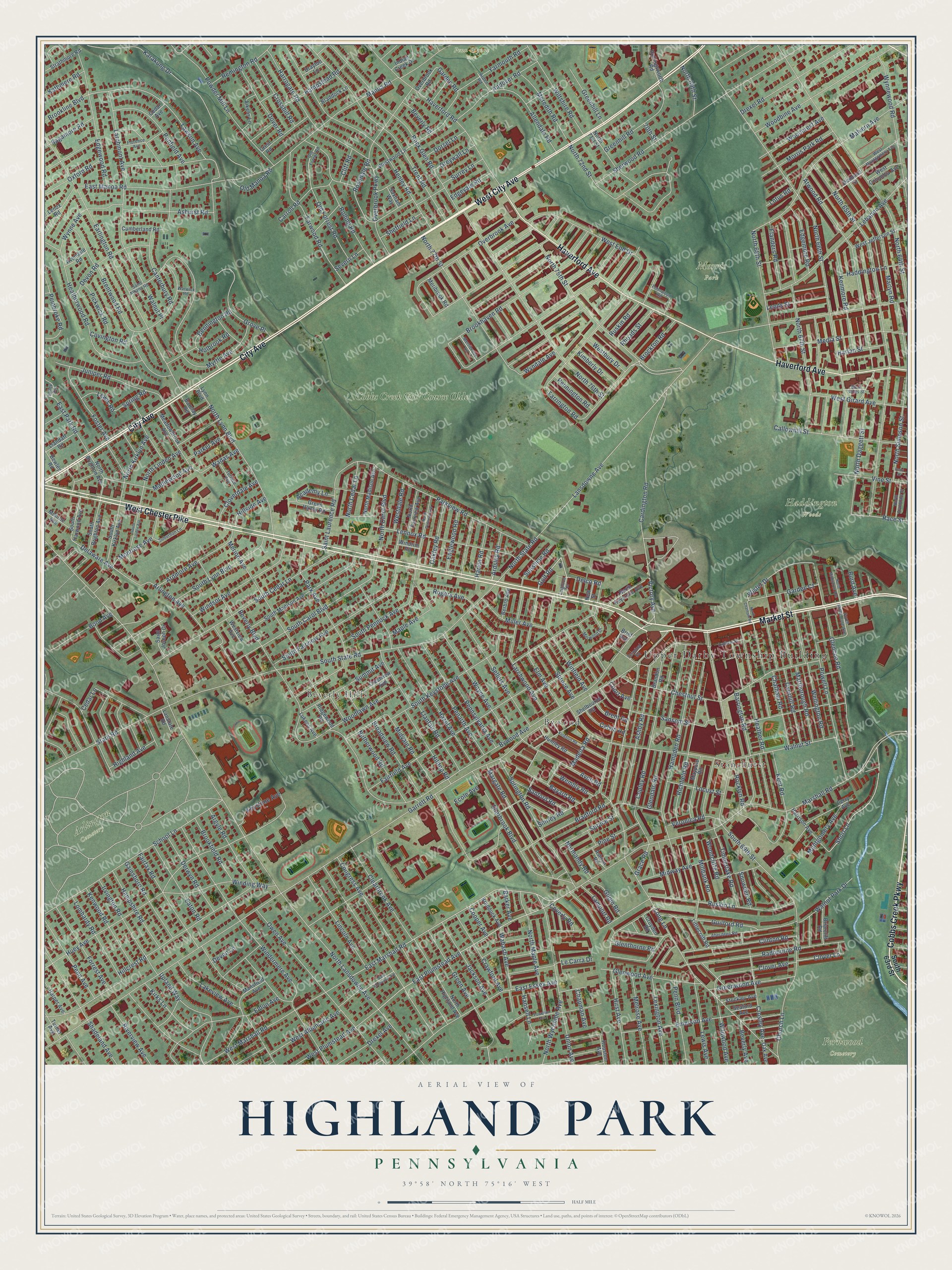
Building by building, with labeled streets and shaded relief.
12" x 18" Archival Matte Print
A Map of Home. A Work of Art.
Explore Highland Park, Pennsylvania from a whole new perspective. Created using aerial imagery and detailed geographic data, this map captures Highland Park building by building, with labeled streets, familiar landmarks, and shaded topographical relief that highlights the natural contours of the landscape.
Combining modern data with the timeless character of a vintage atlas, this map is just as interesting up close as it is beautiful on the wall. Whether you grew up in Highland Park, spent memorable years there, or call it home today, this unique map is a great way to celebrate a place that means something to you. Zoom in on the preview to look for your street, and then order a print to put your memories on the wall.
Three ways to hang it

Unframed archival matte, a black wood frame or a white wood frame.
Up close
Geography Worth Displaying
This map was created using accurate cartographic data and authoritative geographic sources, including the U.S. Geological Survey and the Census Bureau. The map brings together terrain, waterways, roads, and building detail. The majority of the streets are labeled, houses are accurately depicted, and the topography is derived from government sources. Combining local data with carefully composed color and shading leads to this beautifully detailed Highland Park artwork for your wall.
Rather than simply showing street outlines, we’ve included as many of the street names as we could reasonably fit on the map while keeping their names legible. Zoom in on the high resolution preview to see exactly what’s on the map. We truly set out to create a statement piece for anyone who loves Highland Park. So whether it’s for you, or a gift for someone you love, we hope this map of Highland Park brings back fond memories.
Read the story behind this map: Detailed Map of Highland Park, Delaware County, Pennsylvania.

Find your street
Names on the Highland Park map
Every name below is printed on this map. Look for your street, your school, the park where you played, or the pond down the road.
Places and landmarks10
- Upper Darby Township Building
- Arlington Cemetery
- Fernwood Cemetery
- Haddington Woods
- Morris Park
- Penn Wynne Park
- Beverly Hills
- Bywood
- Stonehurst
- Cobbs Creek Golf Course Olde
Streets and roads397
- Market Street
- West Chester Pike
- West City Avenue
- City Avenue
- Haverford Avenue
- Cobbs Creek Parkway
- East Marshall Road
- Delco Road
- East Plumstead Avenue
- Rosedale Road
- Golf Road
- Ashurst Road
- Delaware Avenue
- North 75th Street
- Radbourne Road
- Lawson Avenue
- South Carol Boulevard
- Victory Avenue
- Race Street
- Clover Lane
- Garrett Road
- Lansdowne Avenue
- Beverly Boulevard
- North Lansdowne Avenue
- Marshall Road
- Long Lane
- North 66th Street
- Woodbine Avenue
- Sherwood Road
- Brentwood Road
Show all 397 streets
- Windermere Avenue
- North 65th Street
- Malvern Avenue
- Wayne Avenue
- South State Road
- Copley Road
- Sansom Street
- South 69th Street
- Greenhill Road
- Fairfield Avenue
- Bywood Avenue
- Walnut Street
- Merion Avenue
- Fairfax Road
- North 64th Street
- Earlington Road
- Huey Avenue
- South Keystone Avenue
- Manoa Road
- Chestnut Street
- Hampden Road
- Hillcrest Road
- Guilford Road
- Church Lane
- Wiltshire Road
- Henley Road
- North 76th Street
- Karakung Drive
- Atwood Road
- Myrtle Avenue
- Trent Road
- Kenmore Road
- Marlyn Road
- Woodcrest Avenue
- North 67th Street
- South Cedar Lane
- Rock Glen Road
- School Lane
- Derwyn Road
- East Manoa Road
- Hazel Avenue
- Ruskin Lane
- Clover Avenue
- Owen Avenue
- Congress Avenue
- Springton Road
- Haverford Road
- Kent Road
- East Essex Avenue
- Glendale Road
- Lombardy Road
- Overbrook Parkway
- Windsor Avenue
- Drexel Road
- Lebanon Avenue
- Hirst Avenue
- Overbrook Avenue
- Brookhaven Road
- North 77th Street
- Richfield Road
- Powell Lane
- Heatherwood Road
- Parkview Road
- Heather Road
- Sellers Avenue
- West Marshall Road
- Sherbrook Boulevard
- Ardmore Avenue
- South Fairview Avenue
- Edgemore Road
- North Wycombe Avenue
- Eaton Road
- Powder Mill Lane
- Shirley Road
- Emerson Avenue
- Arlington Avenue
- Crosshill Road
- Harrogate Road
- Irvington Road
- Hilltop Road
- Farwood Road
- North Lynn Boulevard
- Brockton Road
- Lennox Road
- Clinton Road
- Park Avenue
- Cardington Road
- West Albemarle Avenue
- Wynnewood Road
- North Simpson Street
- Glencoe Road
- Walnut Place
- Ashby Road
- State Road
- Eldon Avenue
- Chatham Road
- Gainsboro Road
- Edgewood Road
- Larchwood Avenue
- Covington Road
- Argyle Road
- Midway Avenue
- Media Street
- Shadeland Avenue
- Callowhill Street
- North 68th Street
- Wellington Road
- Margate Road
- Andover Road
- Marlborough Road
- Overhill Road
- Penarth Avenue
- North Daggett Street
- North Linden Avenue
- Green Avenue
- North Maple Avenue
- Surrey Lane
- Old Forrest Road
- Elm Avenue
- Locust Street
- Foster Avenue
- Short Lane
- Juniper Road
- Upland Way
- Saint Laurence Road
- Highland Avenue
- Hampshire Road
- Greenwood Avenue
- Hampstead Road
- Madeira Road
- Pennington Road
- Winding Way
- Barrington Road
- Clearbrook Avenue
- Farrington Road
- Rogers Avenue
- South Lynn Boulevard
- Lincoln Avenue
- North 72nd Street
- Winfield Avenue
- South Pennock Avenue
- Grove Place
- Bradford Road
- Glenwood Avenue
- Crosley Avenue
- Allendale Road
- West Plumstead Avenue
- Lamport Road
- Lakeview Avenue
- Forrest Avenue
- West Girard Avenue
- Larchmont Avenue
- Avon Road
- Summit Avenue
- Devon Road
- Penfield Avenue
- Haddington Lane
- Maplewood Avenue
- West End Drive
- Millbank Road
- Rolling Road
- Bayard Road
- Penn Avenue
- Broadview Road
- Melrose Avenue
- Jackson Avenue
- Crawford Avenue
- North Kirklyn Avenue
- Kenwood Road
- Meredith Road
- Lexington Avenue
- Bennington Road
- Wynne Avenue
- Flanders Road
- North Carol Boulevard
- Wabash Avenue
- Netherwood Road
- Penn Boulevard
- Morris Park Road
- Lewis Avenue
- Ruskin Road
- Maple Avenue
- Yarmouth Road
- Woodlawn Avenue
- Keystone Avenue
- Timberlake Road
- Wister Drive
- Midvale Road
- Dover Road
- Llanfair Road
- Pennsylvania Avenue
- Canterbury Road
- North State Road
- Montrose Avenue
- East Park Road
- Miller Avenue
- Brookfield Road
- Walnut Park Drive
- Garden Court
- Remington Road
- Vine Street
- Pine Street
- Bond Avenue
- Riverview Avenue
- Carroll Road
- Wembly Road
- Kirks Lane
- Wildwood Avenue
- Drexel Avenue
- Oakley Road
- Oxford Road
- Greenhill Lane
- Pembroke Road
- Englewood Road
- Spruce Street
- Devon Lane
- Montgomery Avenue
- Cloverdale Avenue
- Spruce Avenue
- Sanford Road
- Gilpin Road
- Pickwick Road
- Leeds Street
- Garden Road
- Harvin Road
- Sagamore Road
- North Cedar Lane
- Veronica Road
- Ardsley Road
- Union Avenue
- North 69th Street
- Sunshine Road
- Hillside Avenue
- Brookline Boulevard
- Old Manoa Road
- Kimberly Drive
- Westbury Drive
- Woodcliffe Road
- Harlan Street
- Parker Avenue
- Rocklyn Road
- Westdale Road
- Sheffield Lane
- Edgevale Road
- Rhoads Street
- Greywall Lane
- Dorset Lane
- Calvin Road
- Kathmere Road
- Normandy Road
- Glenthorne Road
- Wadas Avenue
- Beverly Avenue
- Hansell Lane
- Academy Lane
- Beverly Road
- Lewis Road
- Chapman Avenue
- Le Carra Drive
- Wyndale Avenue
- Holbrook Road
- Spring Road
- Snowden Road
- Coverly Road
- Brent Road
- Cliff Road
- Severn Lane
- Cooper Avenue
- Lotus Road
- Ecole Avenue
- Barker Avenue
- Court Avenue
- Grace Road
- Burd Avenue
- Cedar Lane
- 70th Street
- South 63rd Street
- South Harwood Avenue
- South Madison Avenue
- Shelbourne Road
- Littlecroft Road
- North Highland Avenue
- Mansfield Avenue
- Westwood Lane
- Huntley Road
- Meadowbrook Avenue
- North Fairview Avenue
- North 71st Street
- Meribrook Road
- Maypole Road
- South Brighton Avenue
- Berbro Avenue
- West Jefferson Street
- Crest Road
- Harrison Avenue
- North Brighton Avenue
- Perry Avenue
- Aikens Lane
- North Madison Avenue
- Westview Avenue
- Diamond Street
- North Keystone Avenue
- Briarcliff Road
- Crestview Avenue
- Lynn Boulevard
- South Kirklyn Avenue
- Green Valley Road
- Ashton Road
- Strathmore Road
- Cumberland Road
- Bewley Road
- Hollingsworth Road
- Drayton Lane
- West Columbia Avenue
- Saint Joseph Drive
- Indian Creek Drive
- Harper Avenue
- Llandaff Road
- Brandon Road
- Stockley Avenue
- Braddock Avenue
- Monroe Avenue
- Braddock Lane
- Brief Avenue
- Overbrook Road
- Lukens Avenue
- Houston Avenue
- Turner Avenue
- Ridgewood Road
- Seaford Avenue
- Avondale Road
- Oak Avenue
- Lanstate Road
- Saxham Way
- Barclay Road
- Croyden Road
- Windrim Road
- Cedar Avenue
- Lenox Road
- New Street
- Leighton Terrace
- South Millbourne Avenue
- Ludlow Street
- Florence Avenue
- Saint Albans Road
- Merribrook Lane
- Aberdeen Road
- Merwood Drive
- West Montgomery Avenue
- Suburban Lane
- North Avondale Street
- Terrace Avenue
- Terminal Square
- Old Forest Road
- Pennwood Road
- Arden Road
- Valley Road
- West Stiles Street
- Warwick Road
- Powelton Avenue
- North Pennock Avenue
- Kingston Road
- South Linden Avenue
- East Albemarle Avenue
- North Millbourne Avenue
- North Chatham Road
- Pearl Street
Names are listed as they appear on the printed map. Zoom into the product photos to find them.
Keep exploring Pennsylvania
Highland Park is one of 3,725 Pennsylvania towns we've mapped. Every dot on the map is a print of its own.
The search covers every state, Pennsylvania first.
Near Highland Park
Order 2 or more town maps and save 10%. Shown in the size and finish you picked above, so they hang as a set.
- Beverly Hills 12" x 18" / Archival Matte Print $39.99
- Bywood 12" x 18" / Archival Matte Print $39.99
- Stonehurst 12" x 18" / Archival Matte Print $39.99

More maps nearby: Millbourne, Overbrook, Upper Darby, Penn Wynne and East Lansdowne.
The art of mapping a place
How This Map Was Made
Real places. Remarkable detail. Discover the layers that turn geographic data into a map of home.

The view from above
Aerial imagery reveals the character of the land: woodland, open fields, and the patterns of a place.

The shape of the land
Elevation data brings hills, valleys, and subtle changes in the landscape into view.

The details of home
Roads, waterways, and building footprints come together to make the map feel unmistakably local.

Geography becomes art
Considered color, shading, and typography bring the layers together in a map made for your wall.


Process illustrated with Mendon, Massachusetts. Aerial imagery: USDA NAIP. Terrain: USGS 3D Elevation Program. Map details and finished artwork: KNOWOL.
The Details
About This Print
Choose an archival matte print, or a black or white Ayous wood frame. The archival matte print is unframed.
Select your size and finish above to see the matching product image and price.
Materials & Craftsmanship
A contemporary map with the character of a classic atlas, printed on archival matte paper. Optional frames are made from Ayous wood.
Your printed map does not include the watermark shown in the full-map preview.
Shipping & Delivery
Free shipping within the United States. Every print is made to order in the USA.
Buying a gift? Add a note in your cart and we'll include it. We never put prices in the package.
Prints ship within 2 to 3 business days. Allow 7 to 10 days total from ordering for delivery. Timing may vary during holidays or periods of high order volume.
Read our shipping policy.
Returns and damaged prints
Each print is made to order. Change-of-mind refunds are not available after production.
If your print arrives damaged, misprinted or incorrect, contact support@knowol.com within 30 days of receiving it. Include your order number, photos and a description of the issue.
Read our full refund and replacement policy. For questions about your order, email support@knowol.com.