
Search for another town


Free U.S. delivery 7 to 10 days after you order
Hopkinsville, Kentucky Map Art
Building by building, with labeled streets and shaded relief.
12" x 18" Archival Matte Print
A Map of Home. A Work of Art.
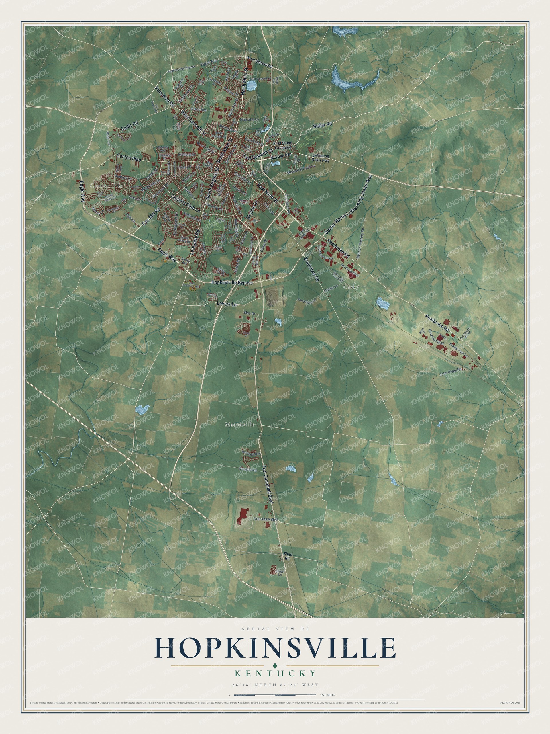
Explore Hopkinsville, Kentucky from a whole new perspective. Created using aerial imagery and detailed geographic data, this map captures Hopkinsville building by building, with labeled streets, familiar landmarks, and shaded topographical relief that highlights the natural contours of the landscape.
Combining modern data with the timeless character of a vintage atlas, this map is just as interesting up close as it is beautiful on the wall. Whether you grew up in Hopkinsville, spent memorable years there, or call it home today, this unique map is a great way to celebrate a place that means something to you. Zoom in on the preview to look for your street, and then order a print to put your memories on the wall.
Three ways to hang it

Unframed archival matte, a black wood frame or a white wood frame.
Up close
Geography Worth Displaying
This map was created using accurate cartographic data and authoritative geographic sources, including the U.S. Geological Survey and the Census Bureau. The map brings together terrain, waterways, roads, and building detail. The majority of the streets are labeled, houses are accurately depicted, and the topography is derived from government sources. Combining local data with carefully composed color and shading leads to this beautifully detailed Hopkinsville artwork for your wall.
Rather than simply showing street outlines, we’ve included as many of the street names as we could reasonably fit on the map while keeping their names legible. Zoom in on the high resolution preview to see exactly what’s on the map. We truly set out to create a statement piece for anyone who loves Hopkinsville. So whether it’s for you, or a gift for someone you love, we hope this map of Hopkinsville brings back fond memories.
Read the story behind this map of Hopkinsville, Kentucky from 2026.

Find your street
Names on the Hopkinsville map
Every name below is printed on this map. Look for your street, your school, the park where you played, or the pond down the road.
Places and landmarks3
- Canton Pike
- Casky
- Masonville
Streets and roads143
- East Ninth Street
- North Main Street
- Pembroke Road
- West Seventh Street
- Lafayette Road
- East Seventh Street
- South Virginia Street
- Eagle Way
- Hopkinsville Bypass
- South Main Street
- Fort Campbell Boulevard
- Doctor Martin Luther King Junior Way
- Country Club Lane
- Bradshaw Road
- Cox Mill Road
- Lovers Lane
- Cadiz Road
- Skyline Drive
- Princeton Road
- Butler Road
- East First Street
- Commerce Court
- Casky Lane
- Frank Yost Lane
- North Elm Street
- North Drive
- Sanderson Drive
- Pyle Lane
- Crenshaw Boulevard
- John Rives Road
Show all 143 streets
- Glass Avenue
- Calvin Drive
- East 21st Street
- Richard Street
- Millbrooke Drive
- Donna Drive
- Sivley Road
- East 18th Street
- South Clay Street
- Springmont Drive
- Beacon Nursery Road
- West 15th Street
- Memorial Field Drive
- Krusteaz Way
- Metcalfe Lane
- Blane Drive
- Major Lane
- Beverly Road
- Faultless Road
- Pardue Lane
- Sherwood Drive
- Marietta Drive
- Koffman Drive
- Morris Lane
- Moores Drive
- Clinic Drive
- Fairview Drive
- Means Avenue
- Msu Drive
- Hunters Lane
- Andrew Drive
- McLean Avenue
- Jefferson Davis Highway
- West Bypass Road
- First Street Extended
- Elmo Road
- Bahama Drive
- Circle Drive
- Harry Berry Lane
- Bill Bryan Boulevard
- Novadell Way
- Stone Valley Drive
- Great Oaks Drive
- Rose Drive
- West Second Street
- Dawn Drive
- Fairfax Avenue
- North Vine Street
- Airport Road
- Old Concord Lane
- Academy Drive
- East 13th Street
- Highpoint Drive
- Apache Avenue
- Wing Tip Circle
- Nelson Drive
- Denzil Drive
- Hammond Drive
- South Walnut Street
- Durrett Avenue
- Faulkner Drive
- Irish Circle
- Katie Peden Drive
- Pawnee Drive
- Camilla Drive
- Burley Avenue
- Hillaire Drive
- Lacy Lane
- Gant Street
- West 19th Street
- Griffin Bell Drive
- Linneth Drive
- Vine Street
- Steger Lane
- Brock Avenue
- Betty Lane
- Lee Lane
- Colt Drive
- Dell Drive
- Old Bypass Road
- East Second Street
- Christian Quarry Road
- Linda Drive
- New Casky Church Road
- Henderson Drive
- Martin Place
- Trad Drive
- Old Edwards Mill Road
- Hermitage Drive
- Riken Court
- Brame Drive
- Braden Street
- Keeton Drive
- Hill Street
- Derby Drive
- Deepwood Drive
- Jerry Claybourne Way
- Pin Oak Drive
- James Drive
- Shadowood Trail
- Industrial Drive
- Noel Avenue
- Colonial Terrace
- Cardinal Drive
- Colonette Drive
- Robin Road
- Vfw Lane
- Boyd Lane
- Hunting Creek Road
- Bridle Way
- Oriole Drive
- Hurst Drive
- Lowes Drive
Names are listed as they appear on the printed map. Zoom into the product photos to find them.
About Hopkinsville, Kentucky
Hopkinsville is a city of 31,180 people and the county seat of Christian County. In 1796 Bartholomew Wood claimed the land here as part of a 1,200-acre grant he had earned in the American Revolution, and he and his wife, Martha Ann, came over from Jonesborough, Tennessee. Christian County was formed that same year, and in 1797 the Woods gave 5 acres and a half share of their Old Rock Spring for the new county seat.
A log courthouse, a jail and a pen for stray animals stood by 1798. A year later, John Campbell and Samuel Means planned the streets of what was then called Christian Court House. Residents wanted to name it Elizabeth, for the Woods' eldest daughter, but Elizabethtown had already claimed that name. So in 1804 the Kentucky Assembly made it the town of Hopkinsville, honoring Samuel Hopkins, a Revolutionary veteran and state representative from Henderson County.
“In the early days, a visit to Hopkinsville was a visit to a great city for those who lived on the scattered farms and in the hills.”
- Courthouse burned in 1864Hopkinsville changed hands between Confederate and Union troops at least half a dozen times during the Civil War. In December 1864, Confederates led by Gen. Hylan B. Lyon took the town and set fire to the Christian County courthouse, which the Union army had been using as barracks.
- The Night Riders of 1907In 1904 Black Patch tobacco planters organized against James B. Duke's American Tobacco Company, whose monopoly let it pay farmers less. When many farmers still sold to the company, a secret group, the Night Riders, turned to terror. On December 7, 1907, 250 masked riders seized Hopkinsville's police station, cut off the town and burned three warehouses, one on the site of today's Peace Park. By the next April, a Paducah tobacco broker wrote that none had been convicted.
- A state hospital since 1854The Western Lunatic Asylum opened here in 1854 and still treats mental illness today as Western State Hospital. In 2004 it cared for 220 patients from 34 western Kentucky counties. The old asylum joined the National Register in 1979.
- Visitors from space, 1955On the night of August 21 and 22, 1955, people near Kelly and Hopkinsville reported a close encounter with beings from another world. UFO researchers count it among the best-documented cases ever, while skeptics blame excitement and sightings of meteors and owls.
- Bowling balls for the worldEbonite International, one of the oldest bowling ball makers, had its headquarters and main factory in Hopkinsville. Its plants here made 60 percent of the world's bowling balls until they closed in November 2019, after Brunswick Bowling Products bought the company.
Keep exploring Kentucky
Hopkinsville is one of 659 Kentucky towns we've mapped. Every dot on the map is a print of its own.
The search covers every state, Kentucky first.
Near Hopkinsville
Order 2 or more town maps and save 10%. Shown in the size and finish you picked above, so they hang as a set.
- Pembroke 12" x 18" / Archival Matte Print $39.99
- Sinking Fork 12" x 18" / Archival Matte Print $39.99
- Gracey 12" x 18" / Archival Matte Print $39.99

More maps nearby: Oak Grove, Fort Campbell North, Trenton, Crofton and Cerulean.
The art of mapping a place
How This Map Was Made
Real places. Remarkable detail. Discover the layers that turn geographic data into a map of home.

The view from above
Aerial imagery reveals the character of the land: woodland, open fields, and the patterns of a place.

The shape of the land
Elevation data brings hills, valleys, and subtle changes in the landscape into view.

The details of home
Roads, waterways, and building footprints come together to make the map feel unmistakably local.

Geography becomes art
Considered color, shading, and typography bring the layers together in a map made for your wall.


Process illustrated with Mendon, Massachusetts. Aerial imagery: USDA NAIP. Terrain: USGS 3D Elevation Program. Map details and finished artwork: KNOWOL.
The Details
About This Print
Choose an archival matte print, or a black or white Ayous wood frame. The archival matte print is unframed.
Select your size and finish above to see the matching product image and price.
Materials & Craftsmanship
A contemporary map with the character of a classic atlas, printed on archival matte paper. Optional frames are made from Ayous wood.
Your printed map does not include the watermark shown in the full-map preview.
Shipping & Delivery
Free shipping within the United States. Every print is made to order in the USA.
Buying a gift? Add a note in your cart and we'll include it. We never put prices in the package.
Prints ship within 2 to 3 business days. Allow 7 to 10 days total from ordering for delivery. Timing may vary during holidays or periods of high order volume.
Read our shipping policy.
Returns and damaged prints
Each print is made to order. Change-of-mind refunds are not available after production.
If your print arrives damaged, misprinted or incorrect, contact support@knowol.com within 30 days of receiving it. Include your order number, photos and a description of the issue.
Read our full refund and replacement policy. For questions about your order, email support@knowol.com.