
Search for another town


Free U.S. delivery 7 to 10 days after you order
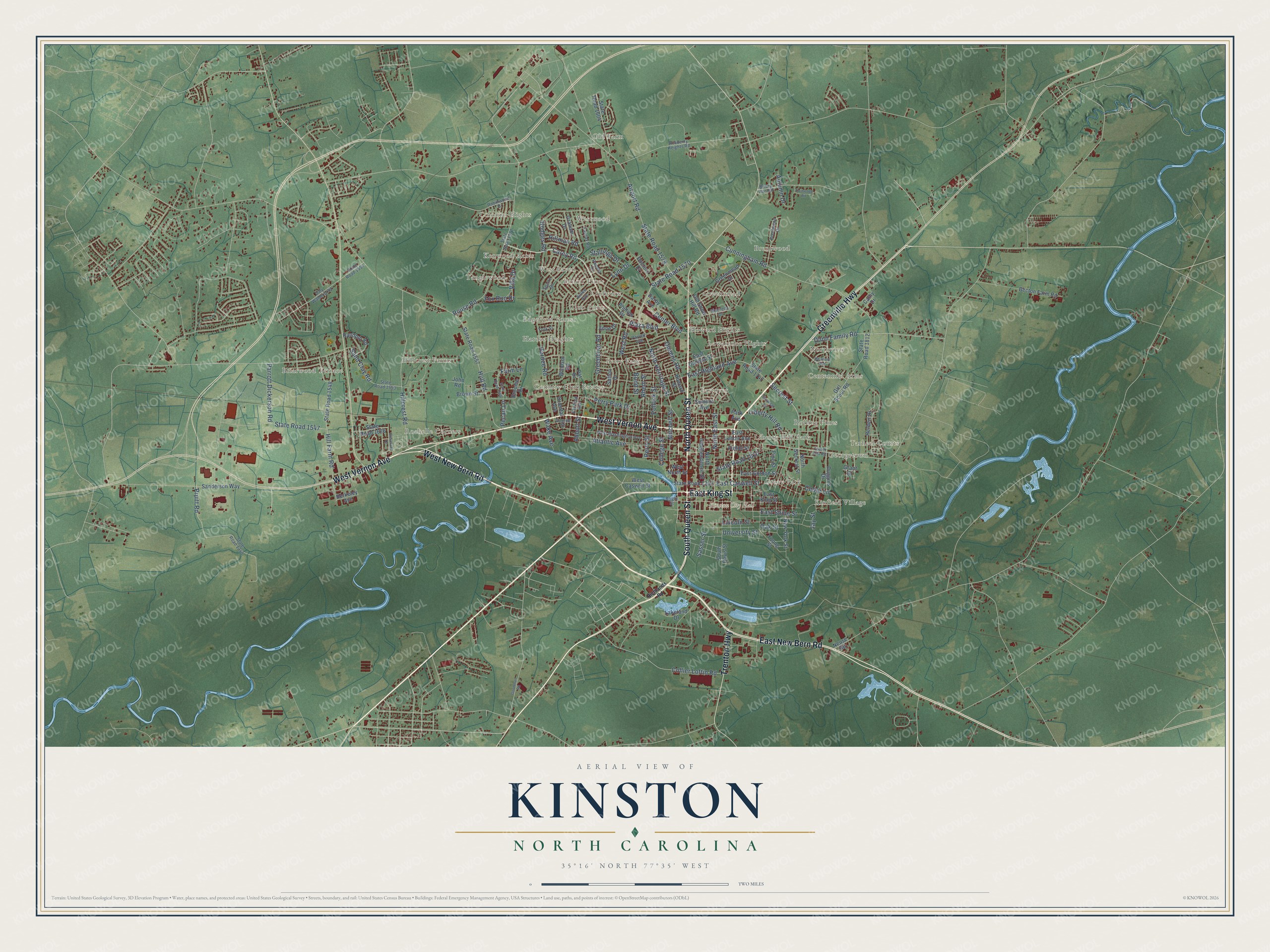
Kinston, North Carolina Map Art
Building by building, with labeled streets and shaded relief.
12" x 18" Archival Matte Print
A Map of Home. A Work of Art.
Explore Kinston, North Carolina from a whole new perspective. Created using aerial imagery and detailed geographic data, this map captures Kinston building by building, with labeled streets, familiar landmarks, and shaded topographical relief that highlights the natural contours of the landscape.
Combining modern data with the timeless character of a vintage atlas, this map is just as interesting up close as it is beautiful on the wall. Whether you grew up in Kinston, spent memorable years there, or call it home today, this unique map is a great way to celebrate a place that means something to you. Zoom in on the preview to look for your street, and then order a print to put your memories on the wall.
Three ways to hang it

Unframed archival matte, a black wood frame or a white wood frame.
Up close
Geography Worth Displaying
This map was created using accurate cartographic data and authoritative geographic sources, including the U.S. Geological Survey and the Census Bureau. The map brings together terrain, waterways, roads, and building detail. The majority of the streets are labeled, houses are accurately depicted, and the topography is derived from government sources. Combining local data with carefully composed color and shading leads to this beautifully detailed Kinston artwork for your wall.
Rather than simply showing street outlines, we’ve included as many of the street names as we could reasonably fit on the map while keeping their names legible. Zoom in on the high resolution preview to see exactly what’s on the map. We truly set out to create a statement piece for anyone who loves Kinston. So whether it’s for you, or a gift for someone you love, we hope this map of Kinston brings back fond memories.
Read the story behind this map of Kinston, North Carolina from 2026.

Find your street
Names on the Kinston map
Every name below is printed on this map. Look for your street, your school, the park where you played, or the pond down the road.
Places and landmarks30
- Kinston City Hall
- Old Farm
- Centennial Arms
- Kenwood Acres
- Hillcrest Farms
- Brentwood
- Eastover
- Kinfield Village
- Country Club Estates
- Westwood
- Greenmead
- Rochelle Corners
Show all 30 places
- Clubview
- Briarwood Terrace
- Rolling Pines
- Perry Park
- Howard Hights
- Edgefield Forest
- Colonial Hights
- Liberty Hill Park
- Tarheel Courts
- Grove Park
- Tanglewood
- West haven
- Lawarence Hights
- Georgetown
- Club Pines
- Northview
- Hardee Heights
- Lenoir Pines
Streets and roads137
- North Queen Street
- East New Bern Road
- Greenville Highway
- South Queen Street
- East King Street
- West New Bern Road
- West Vernon Avenue
- Trenton Highway
- Secrest Street
- East Caswell Street
- Center Boulevard
- Plaza Boulevard
- State Road 1570
- North Herritage Street
- East Highland Avenue
- Carey Road
- Atlantic Avenue
- Hardee Road
- State Road 1810
- Airport Road
- State Road 1578
- Rouse Road
- Hull Road
- Cunningham Road
- Lincoln Street
- West Road
- State Road 1547
- Hodges Road
- East Shine Street
- Greenbriar Road
Show all 137 streets
- Hill Farm Road
- Pollock Street
- Hillcrest Road
- College Street
- Cedar Lane
- Oak Street
- Rhem Street
- North East Street
- Sand Clay Road
- Lynn Drive
- Mitchell Street
- Queens Road
- Pruitt Road
- Autumn Drive
- Dunn Family Road
- Parrott Dickerson Road
- Hillman Road
- Collier Loftin Road
- Liberty Hill Road
- Perry Street
- Farm Lane
- Perry Park Drive
- Stallings Drive
- University Street
- Fox Run Drive
- Sasser Street
- Villa Drive
- Wake Avenue
- Pecan Lane
- Abbott Street
- Bond Street
- Jay Street
- North Secrest Street
- State Road 1353
- State Road 1557
- Girl Scout Road
- State Road 1812
- North Independence Street
- State Road 1747
- Darby Avenue
- State Road 1548
- East Gordon Street
- Old Snow Hill Road
- Summit Avenue
- Greenmead Drive
- Herbert Drive
- South Davis Street
- State Road 1604
- East Lenoir Avenue
- West Caswell Street
- Park Avenue
- Windsor Road
- Sutton Drive
- Sanderson Way
- Doctors Drive
- Becton Farm Road
- Random Road
- Graham Drive
- Phillips Drive
- Duggins Drive
- Fields Street
- Oriental Avenue
- New York Street
- John Road
- Broome Drive
- Brown Street
- State Road 1626
- Howard Street
- East Daniels Street
- Young Street
- Lakeland Drive
- Berkeley Avenue
- Cathy Drive
- West North Street
- Anne Drive
- Pine Street
- Neuse Road
- Grant Street
- Par Drive
- Tower Hill Road
- State Road 1572
- West Washington Avenue
- State Road 1553
- State Road 1340
- Parrott Avenue
- Brentwood Drive
- Daly Waldrop Road
- State Road 1554
- Sparre Drive
- Robinwood Drive
- Fairfax Road
- Briery Run Road
- Pamela Drive
- Airlee Avenue
- Dupree Street
- Academy Heights Road
- Marcella Drive
- Fairfield Avenue
- York Street
- Bright Street
- Richlands Road
- State Road 1566
- Mewborn Avenue
- Cleveland Drive
- Savannah Lane
- Twinwood Road
- Goodman Road
Names are listed as they appear on the printed map. Zoom into the product photos to find them.
About Kinston, North Carolina
Kinston is a city of 19,900 people in Lenoir County, on the Neuse River in the coastal plain of eastern North Carolina. Before the town existed, the bluff above the river was called Atkins Bank, after its owner Robert Atkins. Farmers worked the land there, tobacco was stored in a warehouse on it, and the Church of England kept a mission nearby. In December 1762 the General Assembly created a town on the spot named Kingston, for the new King George III. Richard Caswell, who lived in the town and later became North Carolina's first governor, introduced the bill.
After the Revolution was won, residents changed the name to Kinston in 1784 to show they had turned their backs on royalty. When Dobbs County was abolished in December 1791, Kinston became the seat of the new Lenoir County. In 1833 the town was renamed Caswell for the governor, but Kinston came back a year later. The legislature incorporated it as a town in January 1849, and its population, estimated at 455 in 1850, passed 1000 a decade later.
- King and Queen StreetsThe town's commissioners sold numbered lots by subscription, and each buyer had three years to build a brick house of set size or give the lot up. East, North and South Streets marked three edges, with the Neuse River as the fourth. The two main roads honored King George and Queen Charlotte, and they are still King and Queen Streets. A street named for Governor Arthur Dobbs became Independence Street.
- The ram NeuseDuring the Battle of Wyse Fork, March 7 to 10, 1865, Confederates sank their own ironclad ram Neuse so Union troops could not take it, and Union forces then occupied the city. The wreck was raised and shown at Richard Caswell Park before moving to a climate-controlled museum on Queen Street. It joined the National Register in 2001, and a full-size copy, Ram Neuse II, sits beside the river on Heritage Street.
- Tobacco and cotton townNear the end of the 19th century, Kinston's workshops turned out horse-drawn carriages, and the town grew into a major market for tobacco and cotton. By the start of the 20th century its warehouses were selling more than 5 million pounds of tobacco a year, and some parcels of land rose more than five-fold in value within 20 years.
- Two floods in three yearsHurricane Fran hit the coast on September 5, 1996, and its 16 inches of rain sent the Neuse into parts of the city. Then on September 16, 1999, Hurricane Floyd dropped 17 inches, and locals still call what followed the flood of the century.
- All-America City in 2009The city took home the All-America City Award in 2009, its second win in 21 years. In the 2017 city elections, Dontario Hardy defeated incumbent B.J. Murphy by 205 votes, and the voters seated Kinston's first city council made up entirely of African-American members.
Keep exploring North Carolina
Kinston is one of 952 North Carolina towns we've mapped. Every dot on the map is a print of its own.
The search covers every state, North Carolina first.
Near Kinston
Order 2 or more town maps and save 10%. Shown in the size and finish you picked above, so they hang as a set.
- Jackson Heights 12" x 18" / Archival Matte Print $39.99
- Graingers 12" x 18" / Archival Matte Print $39.99
- Savannah 12" x 18" / Archival Matte Print $39.99


More maps nearby: Woodington, Southwood, Dover, Hookerton and Moss Hill.
The art of mapping a place
How This Map Was Made
Real places. Remarkable detail. Discover the layers that turn geographic data into a map of home.

The view from above
Aerial imagery reveals the character of the land: woodland, open fields, and the patterns of a place.

The shape of the land
Elevation data brings hills, valleys, and subtle changes in the landscape into view.

The details of home
Roads, waterways, and building footprints come together to make the map feel unmistakably local.

Geography becomes art
Considered color, shading, and typography bring the layers together in a map made for your wall.


Process illustrated with Mendon, Massachusetts. Aerial imagery: USDA NAIP. Terrain: USGS 3D Elevation Program. Map details and finished artwork: KNOWOL.
The Details
About This Print
Choose an archival matte print, or a black or white Ayous wood frame. The archival matte print is unframed.
Select your size and finish above to see the matching product image and price.
Materials & Craftsmanship
A contemporary map with the character of a classic atlas, printed on archival matte paper. Optional frames are made from Ayous wood.
Your printed map does not include the watermark shown in the full-map preview.
Shipping & Delivery
Free shipping within the United States. Every print is made to order in the USA.
Buying a gift? Add a note in your cart and we'll include it. We never put prices in the package.
Prints ship within 2 to 3 business days. Allow 7 to 10 days total from ordering for delivery. Timing may vary during holidays or periods of high order volume.
Read our shipping policy.
Returns and damaged prints
Each print is made to order. Change-of-mind refunds are not available after production.
If your print arrives damaged, misprinted or incorrect, contact support@knowol.com within 30 days of receiving it. Include your order number, photos and a description of the issue.
Read our full refund and replacement policy. For questions about your order, email support@knowol.com.