
Search for another town


Free U.S. delivery 7 to 10 days after you order
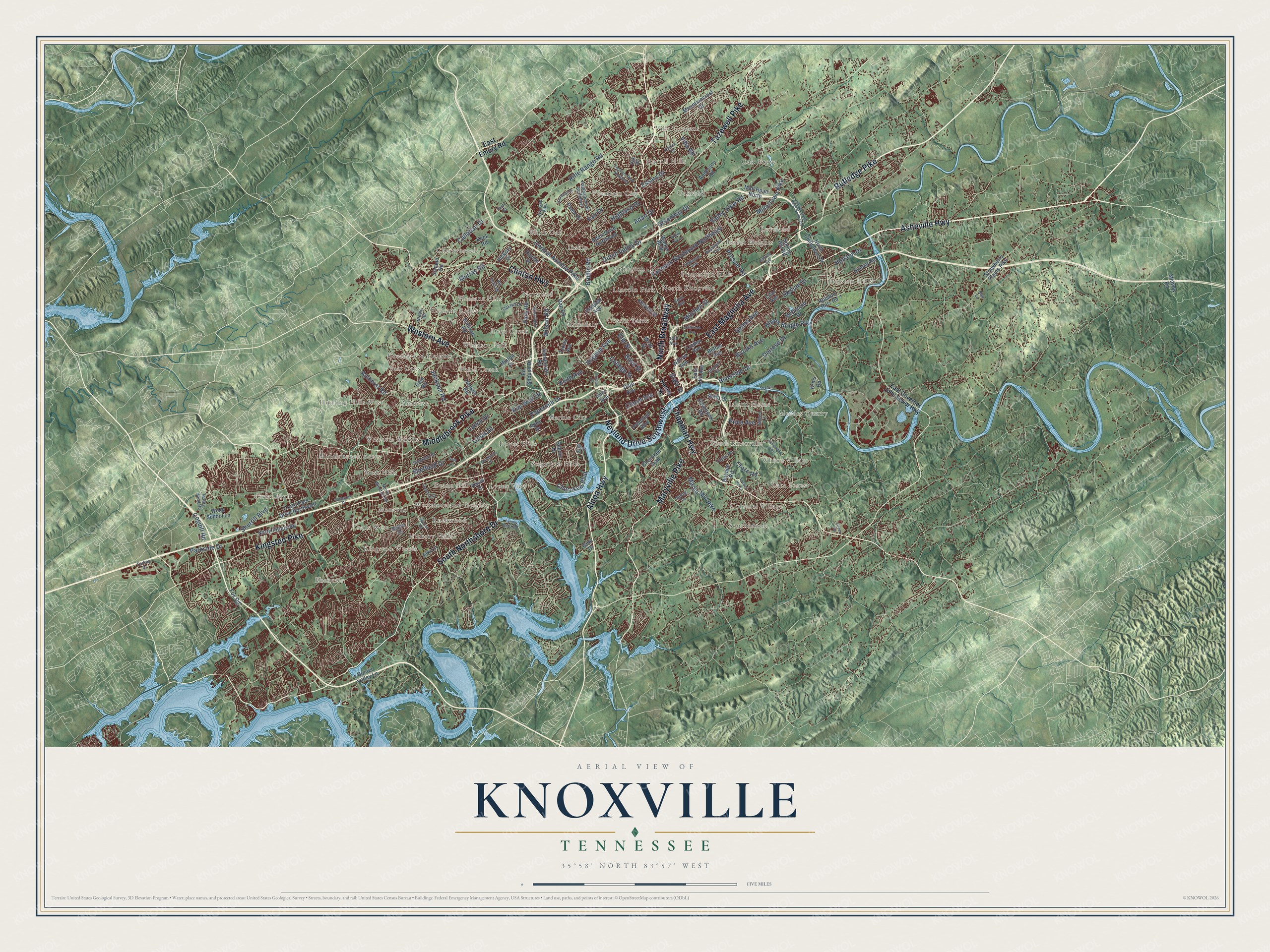
Knoxville, Tennessee Map Art
Building by building, with labeled streets and shaded relief.
12" x 18" Archival Matte Print
A Map of Home. A Work of Art.
Explore Knoxville, Tennessee from a whole new perspective. Created using aerial imagery and detailed geographic data, this map captures Knoxville building by building, with labeled streets, familiar landmarks, and shaded topographical relief that highlights the natural contours of the landscape.
Combining modern data with the timeless character of a vintage atlas, this map is just as interesting up close as it is beautiful on the wall. Whether you grew up in Knoxville, spent memorable years there, or call it home today, this unique map is a great way to celebrate a place that means something to you. Zoom in on the preview to look for your street, and then order a print to put your memories on the wall.
Three ways to hang it

Unframed archival matte, a black wood frame or a white wood frame.
Up close
Geography Worth Displaying
This map was created using accurate cartographic data and authoritative geographic sources, including the U.S. Geological Survey and the Census Bureau. The map brings together terrain, waterways, roads, and building detail. The majority of the streets are labeled, houses are accurately depicted, and the topography is derived from government sources. Combining local data with carefully composed color and shading leads to this beautifully detailed Knoxville artwork for your wall.
Rather than simply showing street outlines, we’ve included as many of the street names as we could reasonably fit on the map while keeping their names legible. Zoom in on the high resolution preview to see exactly what’s on the map. We truly set out to create a statement piece for anyone who loves Knoxville. So whether it’s for you, or a gift for someone you love, we hope this map of Knoxville brings back fond memories.
Read the story behind this map of Knoxville, Tennessee from 2026.

Find your street
Names on the Knoxville map
Every name below is printed on this map. Look for your street, your school, the park where you played, or the pond down the road.
Places and landmarks50
- Third Creek
- Inskip
- Colonial Village
- Oakland
- Island Home
- Holston Hills
- Cherrybrook
- Lyons View
- Amherst
- Villa Gardens
- Coster Yards
- South Knoxville
Show all 50 places
- Marble City
- Pleasant Ridge
- Sequoyah Hills
- Oak Grove
- Deane Hill
- Norwood
- Loveland
- Lake Forest
- Hunting Hills West
- Plantation Hills
- Lincoln Park
- Montvue
- Cedar Bluff
- Rothwood
- Ebenezer
- Westavia Woods
- Fair Oaks
- Pleasant Hills
- Greenwood Heights
- Kingston Woods
- Meades Quarry
- Windsor Park
- Lonsdale
- Buffat Heights
- Fountain City
- Southbrook
- Whites Village
- Deep Creek
- West Hills
- North Knoxville
- Westmoreland Heights
- Hickory Hills
- Arlington
- Black Oak
- Trails West
- Forest Hills
- Harrill Hills
- Middlebrook Acres
Streets and roads156
- Asheville Highway
- Rutledge Pike
- North Broadway
- Western Avenue
- Chapman Highway
- South Northshore Drive
- Neyland Drive Southwest
- East Magnolia Avenue
- Maryville Pike
- Alcoa Highway
- Kingston Pike
- Middlebrook Pike
- Tazewell Pike
- Clinton Highway
- Virginia Avenue
- Cherokee Boulevard
- Papermill Drive
- Parkside Drive
- Riverside Drive
- Central Avenue Pike
- Holston Drive
- Lonas Drive
- Amherst Road
- Sherrill Boulevard
- Murray Road
- Callahan Drive
- Valley View Road
- Greenway Drive
- Highland Drive
- Martin Mill Pike
Show all 156 streets
- Fairmont Boulevard Northeast
- Dutch Valley Drive
- Boyds Bridge Pike
- Skyline Drive
- Adair Drive
- Bruhin Road
- Fair Drive
- Clinch Avenue
- Rifle Range Road
- Sheffield Drive
- Cogdill Road
- Selma Avenue
- Brooks Avenue
- Wilson Road
- Delrose Drive
- Prosser Road
- Keith Avenue
- Millertown Pike
- Essary Drive
- Villa Road
- Jackson Road
- Mitchell Street
- Cruze Road
- Kim Watt Drive
- College Street
- Price Avenue
- Elm Street
- Lance Drive
- State Street
- Boyd Street
- East Emory Road
- East Hill Avenue
- Holston Hills Road
- Linden Avenue
- Sunset Road
- Strawberry Plains Pike
- Cherokee Trail
- Adair Drive Northeast
- Sullivan Road
- Schaad Road
- Henson Road
- Sanderson Road
- Volunteer Boulevard
- Spring Hill Road
- Davenport Road
- North Peters Road
- Ed Shouse Drive
- Kenyon Street
- Cross Park Drive Northwest
- Texas Avenue
- Keck Road
- Walker Boulevard
- Scenic Drive
- Mountaincrest Drive
- McDonald Drive
- Mall Road North
- North Chilhowee Drive
- Gap Road
- Lilac Avenue
- Webb School Lane
- Ailor Avenue
- Baum Drive
- Sabre Drive
- Bethel Avenue
- Paris Road
- Busbee Road
- Hickory Drive
- Anderson Road
- Kreis Road
- Paula Drive
- Heiskell Avenue
- Willow Avenue
- Hunter Valley Lane
- Anita Drive
- Ginn Drive
- Dale Avenue
- Davida Drive
- Cain Road
- Midway Road
- Fox Road
- Hinton Drive
- Alki Lane
- Apex Drive
- Wray Street
- Henley Street
- East Governor John Sevier Highway
- Cecil Avenue
- Dry Gap Pike
- Nickle Road
- Mabry Hood Road
- Parkdale Road Northeast
- Taylor Road
- Stockton Drive
- Oakhill Drive
- Gilbert Lane
- North Winston Road
- Gill Avenue
- Wil Loyd Drive
- Groner Drive
- Oak Road
- Turkey Drive
- Spring Drive
- Bluff Drive
- Bell Lane
- Morrell Road
- Washington Pike
- Sevierville Pike
- Garden Drive
- Jefferson Avenue
- Edgewood Avenue
- Loves Creek Road Northeast
- Lyons Bend Road
- Fountain Road Northeast
- Snowdon Drive
- Cheshire Drive
- Rambling Drive
- Proctor Street
- Walbrook Drive
- Woodburn Drive
- Locust Hill Lane
- White Oak Lane
- Hillview Avenue
- Spence Place
- Green Road
- Dante Road
- Gate Lane
Names are listed as they appear on the printed map. Zoom into the product photos to find them.
About Knoxville, Tennessee
Knoxville is a city of 190,740 people and the seat of Knox County, on the Tennessee River in East Tennessee. In 1790 White's son-in-law, Charles McClung, laid out sixty-four half-acre lots between First and Second creeks. He kept the waterfront as a town common and saved lots for a church and a school. That school became Blount College, and the University of Tennessee counts 1794 as its own founding year.
Also in 1790, George Washington made William Blount governor of the new Territory South of the River Ohio. Blount signed the Treaty of Holston with the Cherokee at White's Fort in 1791. The Cherokee would not give up the land where Kingston now stands, so he chose the fort as his capital instead. He named it for his superior, Secretary of War Henry Knox. Knoxville was capital of the territory and then of Tennessee, a state from 1796, until the capital moved to Murfreesboro in 1817.
- The railroad comes in 1855Flatboats and later steamboats made the riverfront a trading center. Local tobacco, corn and whiskey were swapped there for cotton from the Deep South. Two lines, the East Tennessee and Georgia and the East Tennessee and Virginia railroads, met here in 1855. That ended the town's long isolation, and Knoxville's population more than doubled during the 1850s.
- A divided city in 1863Knox County voted against secession in 1861, but the city voted for it by 2 to 1. Confederate troops held the town until Union General Ambrose Burnside arrived in September 1863 and ringed it with forts. Union General William P. Sanders was mortally wounded west of town on November 18, and Fort Loudon was renamed Fort Sanders for him. With the city under Union occupation, the Unionist editor William G. "Parson" Brownlow came home in triumph that year.
- The founder's son for presidentHugh Lawson White, the son of James White, was born in 1773. He served as a judge and a state senator. In 1825 the legislature chose him to take Andrew Jackson's seat in the U.S. Senate. In 1836 he ran for president as a Whig and lost, and he died in 1840.
- TVA headquarters since 1933Knoxville hosted Appalachian Expositions in 1910 and 1911 and the National Conservation Exposition in 1913. Under the New Deal, the Tennessee Valley Authority made the city its headquarters in 1933 and became a major employer. The 1982 World's Fair later helped bring new life to downtown.
Keep exploring Tennessee
Knoxville is one of 640 Tennessee towns we've mapped. Every dot on the map is a print of its own.
The search covers every state, Tennessee first.
Near Knoxville
Order 2 or more town maps and save 10%. Shown in the size and finish you picked above, so they hang as a set.
- Parkridge 12" x 18" / Archival Matte Print $39.99
- Fountain City 12" x 18" / Archival Matte Print $39.99
- Colonial Village 12" x 18" / Archival Matte Print $39.99


More maps nearby: West Hills, Holston Hills, Powell, Bonny Kate and Halls Crossroads.
The art of mapping a place
How This Map Was Made
Real places. Remarkable detail. Discover the layers that turn geographic data into a map of home.

The view from above
Aerial imagery reveals the character of the land: woodland, open fields, and the patterns of a place.

The shape of the land
Elevation data brings hills, valleys, and subtle changes in the landscape into view.

The details of home
Roads, waterways, and building footprints come together to make the map feel unmistakably local.

Geography becomes art
Considered color, shading, and typography bring the layers together in a map made for your wall.


Process illustrated with Mendon, Massachusetts. Aerial imagery: USDA NAIP. Terrain: USGS 3D Elevation Program. Map details and finished artwork: KNOWOL.
The Details
About This Print
Choose an archival matte print, or a black or white Ayous wood frame. The archival matte print is unframed.
Select your size and finish above to see the matching product image and price.
Materials & Craftsmanship
A contemporary map with the character of a classic atlas, printed on archival matte paper. Optional frames are made from Ayous wood.
Your printed map does not include the watermark shown in the full-map preview.
Shipping & Delivery
Free shipping within the United States. Every print is made to order in the USA.
Buying a gift? Add a note in your cart and we'll include it. We never put prices in the package.
Prints ship within 2 to 3 business days. Allow 7 to 10 days total from ordering for delivery. Timing may vary during holidays or periods of high order volume.
Read our shipping policy.
Returns and damaged prints
Each print is made to order. Change-of-mind refunds are not available after production.
If your print arrives damaged, misprinted or incorrect, contact support@knowol.com within 30 days of receiving it. Include your order number, photos and a description of the issue.
Read our full refund and replacement policy. For questions about your order, email support@knowol.com.