
Search for another town


Free U.S. delivery 7 to 10 days after you order
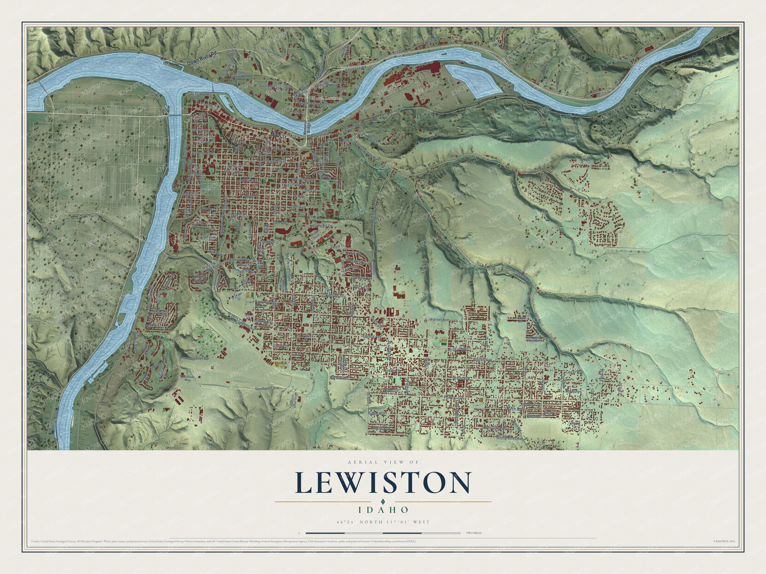
Lewiston, Idaho Map Art
Building by building, with labeled streets and shaded relief.
12" x 18" Archival Matte Print
A Map of Home. A Work of Art.
Explore Lewiston, Idaho from a whole new perspective. Created using aerial imagery and detailed geographic data, this map captures Lewiston building by building, with labeled streets, familiar landmarks, and shaded topographical relief that highlights the natural contours of the landscape.
Combining modern data with the timeless character of a vintage atlas, this map is just as interesting up close as it is beautiful on the wall. Whether you grew up in Lewiston, spent memorable years there, or call it home today, this unique map is a great way to celebrate a place that means something to you. Zoom in on the preview to look for your street, and then order a print to put your memories on the wall.
Three ways to hang it

Unframed archival matte, a black wood frame or a white wood frame.
Up close
Geography Worth Displaying
This map was created using accurate cartographic data and authoritative geographic sources, including the U.S. Geological Survey and the Census Bureau. The map brings together terrain, waterways, roads, and building detail. The majority of the streets are labeled, houses are accurately depicted, and the topography is derived from government sources. Combining local data with carefully composed color and shading leads to this beautifully detailed Lewiston artwork for your wall.
Rather than simply showing street outlines, we’ve included as many of the street names as we could reasonably fit on the map while keeping their names legible. Zoom in on the high resolution preview to see exactly what’s on the map. We truly set out to create a statement piece for anyone who loves Lewiston. So whether it’s for you, or a gift for someone you love, we hope this map of Lewiston brings back fond memories.
Read the story behind this map of Lewiston, Idaho from 2026.

Find your street
Names on the Lewiston map
Every name below is printed on this map. Look for your street, your school, the park where you played, or the pond down the road.
Places and landmarks2
- Lewiston Orchards
- North Lewiston
Streets and roads172
- Main Street
- Down River Road
- 21st Street
- Bryden Canyon Road
- Linsey Creek Road
- 15th Street
- Stewart Avenue
- 460 Road
- Lindsay Creek Road
- Nez Perce Drive
- Burrell Avenue
- Cedar Avenue
- Grelle Avenue
- Airway Avenue
- Powers Avenue
- Snake River Avenue
- Thain Road
- 14th Street
- Tenth Street
- Seventh Street
- Warner Avenue
- Alder Avenue
- Eighth Street
- 17th Street
- 16th Street
- Bryden Avenue
- Sixth Street
- Eleventh Street
- 13th Street
- Linden Avenue
Show all 172 streets
- Birch Avenue
- Fifth Street
- 18th Street
- Ripon Avenue
- Eighth Avenue
- Hemlock Avenue
- Ninth Street
- Oconner Road
- Fourth Street
- Eleventh Avenue
- Preston Avenue
- Twelfth Street
- Ninth Avenue
- Dike Bypass
- 16th Avenue
- Park Avenue
- 17th Avenue
- 19th Street
- Country Club Drive
- Twelfth Avenue
- 15th Avenue
- 14th Avenue
- Richardson Avenue
- 18th Avenue
- 20th Street
- Seventh Avenue
- Hatwai Road
- Third Street
- Prospect Avenue
- Vista Avenue
- Southport Avenue
- 13th Avenue
- Railroad Avenue
- Tenth Avenue
- Third Avenue North
- 22nd Street
- 23rd Street
- Idaho Street
- 29th Street
- Juniper Drive
- Nez Perce Grade
- Vineyard Drive
- 21st Avenue
- 19th Avenue
- 24th Street
- 150 Road
- Albright Grade Road
- First Street
- Old Spiral Highway
- Frontage Road
- Fifth Avenue
- Gun Club Road
- Vineyard Avenue
- Sixth Avenue North
- Birch Drive
- Powers Drive
- Lakeview Drive
- Reservoir Drive
- Airway Drive
- Fourth Avenue
- Duthie Boulevard
- 23rd Avenue
- Carol Drive
- Alder Drive
- Sunset Drive
- North Street
- 25th Avenue
- Birch Court
- 26th Street
- Colonel Wright Way
- Shiloh Drive
- East Main Street
- Tamarack Drive
- Mill Road
- Seaport Drive
- 22nd Avenue
- Grelle Drive
- Hemlock Drive
- Capital Street
- 27th Street
- Third Avenue
- Barr Road
- Port Drive
- Miller Street
- First Avenue
- Bryden Drive
- Second Street
- Seventh Avenue North
- Cypress Street
- Linden Drive
- Eighth Street East
- Cedar Drive
- Crestline Circle Drive
- Park Drive
- Mayfair Drive
- Sixth Avenue
- Eighth Avenue North
- Pride Rock
- 24th Avenue
- Fairway Drive
- Valley Vista Boulevard
- 401 Road
- 14th Street East
- Marine View Drive
- Broadview Drive
- 20th Avenue
- Foothill Drive
- Delsol Lane
- Morgan Avenue
- Silcott Street
- Ridgeway Drive
- Preston Drive
- 27th Avenue
- 30th Street
- Clearview Point Drive
- Park Street
- North And South Highway
- American Way
- Warren Street
- Pioneer Drive
- Harvest Road
- Ripon Drive
- Memorial Bridge
- Old Gun Club Road
- Echo Hills Drive
- Old Sixth Street Grade
- Burrell Drive
- 28th Street North
- Hillcrest Road
- Hawthorne Street
- Beachey Street
- Warner Drive
- North Garden Court
- Second Avenue
- Skyline Drive
- Willow Drive
- Elks Drive
- Adams Lane
- First Avenue North
- Selway Drive
- Karin Avenue
- Gateway Drive
Names are listed as they appear on the printed map. Zoom into the product photos to find them.
About Lewiston, Idaho
Lewiston is a city of 34,203 people and the county seat of Nez Perce County, where the Clearwater River flows into the Snake. In August 1860 Elias D. Pierce slipped onto the Nez Perce reservation dressed as a traveling trader and found gold near Pierce. Thousands of miners followed him onto Nez Perce land, and in 1861 they set up the camp that became Lewiston. It is thought to be named for Meriwether Lewis, who camped on this spot in October 1805.
By 1862 the miners knew there was no gold at Lewiston itself, and many pushed farther into Nez Perce country. The town stayed, though. The Washington Territorial Legislature incorporated it in January 1863, and in March 1863 it became the first capital of the new Idaho Territory. The honor didn't last, because on December 7, 1864, the territorial legislature voted to move the capital south to Boise.
- Idaho's only seaportLower Granite Dam, finished in 1975, backed the Snake River up to Lewiston, and locks on the Snake and Columbia opened the town to river traffic from the Pacific. The first barge, full of wheat, left for Portland on August 9, 1975. No port linked to the ocean sits farther inland, and about ten percent of the nation's wheat exports now pass through it.
- Idaho's lowest pointThe lowest spot in the state is on the Snake River at Lewiston, where the Clearwater joins it and the river turns west into Washington. Downtown sits between 740 and 780 feet, only a little above the water, which stood thirty feet lower before the dam was built.
- The Orchards, annexed in 1969The southern half of the city, high on a plateau at about 1,400 feet, is called the Orchards for the fruit trees that once covered its 9,000 acres of farmland. Lewiston annexed it in late 1969, which doubled the city's area and nearly doubled its population. Fruit trees still grow in many of its backyards.
- The Round Up every SeptemberThe Lewiston Round Up rodeo is one of the Big 4, along with Pendleton, Walla Walla and Ellensburg, and ranks among the top 50 PRCA rodeos. Each spring the city holds the Dogwood Festival, and each May Lewis-Clark State College hosts the NAIA World Series for college baseball.
Keep exploring Idaho
Lewiston is one of 279 Idaho towns we've mapped. Every dot on the map is a print of its own.
The search covers every state, Idaho first.
Near Lewiston
Order 2 or more town maps and save 10%. Shown in the size and finish you picked above, so they hang as a set.
- Lapwai 12" x 18" / Archival Matte Print $39.99
- Sweetwater 12" x 18" / Archival Matte Print $39.99
- Genesee 12" x 18" / Archival Matte Print $39.99


More maps nearby: Culdesac, Juliaetta, Winchester, Kendrick and Reubens.
The art of mapping a place
How This Map Was Made
Real places. Remarkable detail. Discover the layers that turn geographic data into a map of home.

The view from above
Aerial imagery reveals the character of the land: woodland, open fields, and the patterns of a place.

The shape of the land
Elevation data brings hills, valleys, and subtle changes in the landscape into view.

The details of home
Roads, waterways, and building footprints come together to make the map feel unmistakably local.

Geography becomes art
Considered color, shading, and typography bring the layers together in a map made for your wall.


Process illustrated with Mendon, Massachusetts. Aerial imagery: USDA NAIP. Terrain: USGS 3D Elevation Program. Map details and finished artwork: KNOWOL.
The Details
About This Print
Choose an archival matte print, or a black or white Ayous wood frame. The archival matte print is unframed.
Select your size and finish above to see the matching product image and price.
Materials & Craftsmanship
A contemporary map with the character of a classic atlas, printed on archival matte paper. Optional frames are made from Ayous wood.
Your printed map does not include the watermark shown in the full-map preview.
Shipping & Delivery
Free shipping within the United States. Every print is made to order in the USA.
Buying a gift? Add a note in your cart and we'll include it. We never put prices in the package.
Prints ship within 2 to 3 business days. Allow 7 to 10 days total from ordering for delivery. Timing may vary during holidays or periods of high order volume.
Read our shipping policy.
Returns and damaged prints
Each print is made to order. Change-of-mind refunds are not available after production.
If your print arrives damaged, misprinted or incorrect, contact support@knowol.com within 30 days of receiving it. Include your order number, photos and a description of the issue.
Read our full refund and replacement policy. For questions about your order, email support@knowol.com.