
Search for another town


Free U.S. delivery 7 to 10 days after you order
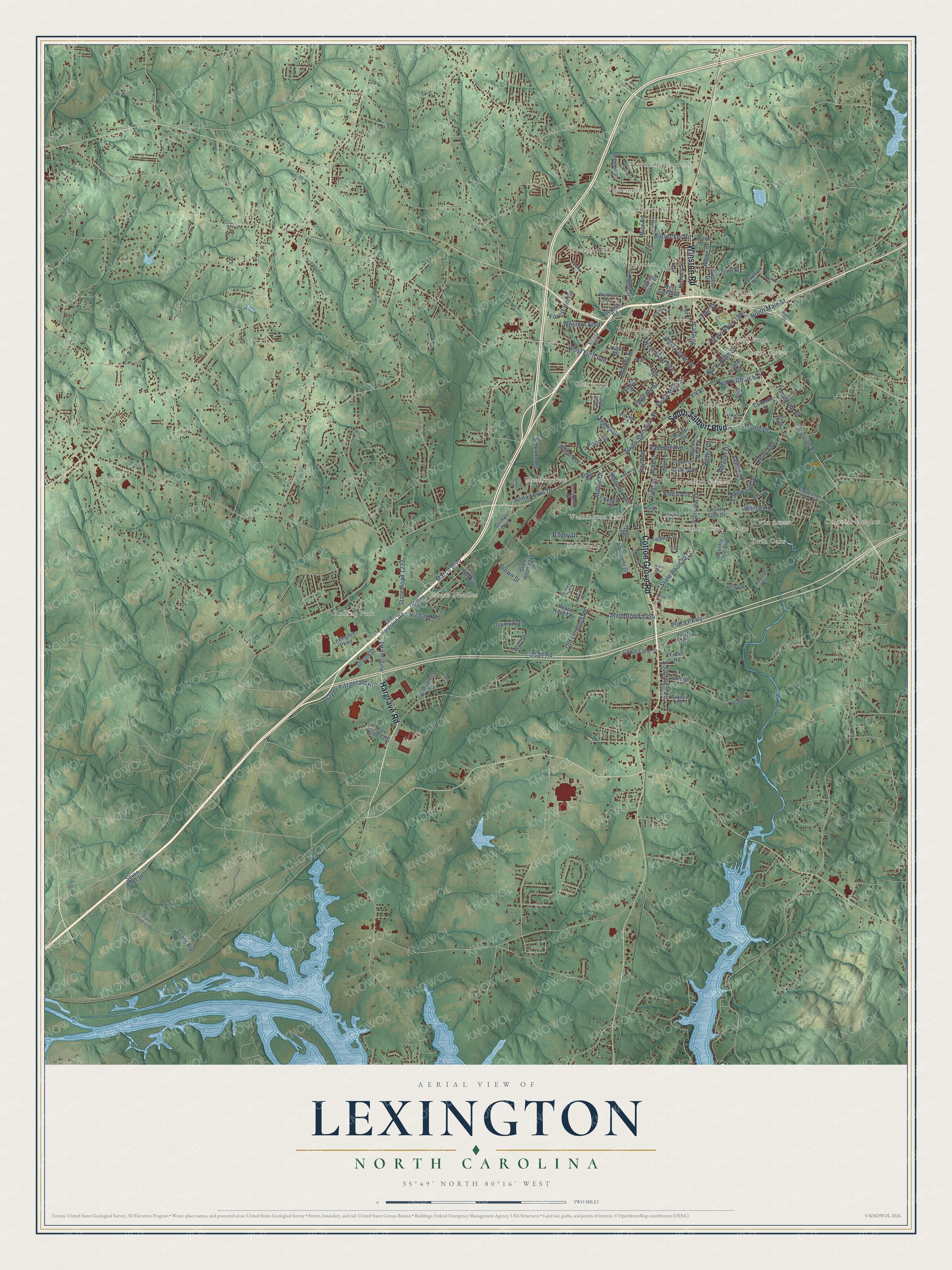
Lexington, North Carolina Map Art
Building by building, with labeled streets and shaded relief.
12" x 18" Archival Matte Print
A Map of Home. A Work of Art.
Explore Lexington, North Carolina from a whole new perspective. Created using aerial imagery and detailed geographic data, this map captures Lexington building by building, with labeled streets, familiar landmarks, and shaded topographical relief that highlights the natural contours of the landscape.
Combining modern data with the timeless character of a vintage atlas, this map is just as interesting up close as it is beautiful on the wall. Whether you grew up in Lexington, spent memorable years there, or call it home today, this unique map is a great way to celebrate a place that means something to you. Zoom in on the preview to look for your street, and then order a print to put your memories on the wall.
Three ways to hang it

Unframed archival matte, a black wood frame or a white wood frame.
Up close
Geography Worth Displaying
This map was created using accurate cartographic data and authoritative geographic sources, including the U.S. Geological Survey and the Census Bureau. The map brings together terrain, waterways, roads, and building detail. The majority of the streets are labeled, houses are accurately depicted, and the topography is derived from government sources. Combining local data with carefully composed color and shading leads to this beautifully detailed Lexington artwork for your wall.
Rather than simply showing street outlines, we’ve included as many of the street names as we could reasonably fit on the map while keeping their names legible. Zoom in on the high resolution preview to see exactly what’s on the map. We truly set out to create a statement piece for anyone who loves Lexington. So whether it’s for you, or a gift for someone you love, we hope this map of Lexington brings back fond memories.
Read the story behind this map of Lexington, North Carolina from 2026.

Find your street
Names on the Lexington map
Every name below is printed on this map. Look for your street, your school, the park where you played, or the pond down the road.
Places and landmarks22
- Glenwood
- Rolling Park
- Northside Gardens
- Montclair
- Colonial Heights
- North Pugh
- Country Club Estates
- Pleasant Hills
- Green Needles
- South Cecil
- Royal Park
- Jefferson Village
Show all 22 places
- Meadowview
- Meredith Square
- Choyce Acres
- Washington Park
- Twin Acres
- Hillcrest
- Woodcrest
- Whitesmith
- Twin Oaks
- Tussy Street
Streets and roads137
- Cotton Grove Road
- South Talbert Boulevard
- Hargrave Road
- Winston Road
- South Main Street
- North Main Street
- West Center Street
- Weaver Drive
- Raleigh Road
- Old Linwood Road
- Marco Boulevard
- Fairview Drive
- State Road 2212
- Brown Street
- State Road 1254
- State Road 1222
- State Road 1844
- South Salisbury Street
- West Fifth Avenue
- Plaza Parkway
- Moore Drive
- Clark Road
- Quail Road
- West Third Avenue
- Hargrave Street
- Young Drive
- Biesecker Road
- Sink Inn Road
- Clyde Fitzgerald Road
- Dixie Street
Show all 137 streets
- Raeford Avenue
- White Street
- Richard Road
- Holt Street
- Smith Avenue
- Lakewood Drive
- Market Street
- Kildee Drive
- Oak Avenue
- North Church Street
- Foy Avenue
- Hames Street
- Maegeo Drive
- Dixon Street
- Southview Road
- Mendota Avenue
- Baney Drive
- North Pugh Street
- Anna Lewis Drive
- Western Boulevard
- Thomason Street
- Forest Hill Road
- Trailer Drive
- Salem Street
- Fair Street
- Dearr Drive
- Pope Street
- Woodberry Drive
- Elk Street
- Country Club Drive
- Service Road
- Seven Oaks Drive
- Old Hargrave Road
- Grimes Boulevard
- Hoover Drive
- Swing Dairy Road
- Lexington Parkway
- Hillside Drive
- Albemarle Street
- Country Club Boulevard
- Bremen Drive
- State Road 1318
- Wren Drive
- Eastside Drive
- Prospect Street
- Myers Park Drive
- Fairfax Road
- Mize Road
- Hamilton Road
- Cedar Lane Drive
- Acacia Circle
- State Road 1391
- Fuller Road
- Robbins Street
- Osprey Trail
- Federal Street
- Grimes Road
- Peace Haven Drive
- Elenor Drive
- Snider Avenue
- Cornelia Street
- Foyell Street
- Flynt Street
- West Eighth Street
- Conner Street
- Quail Lane
- Hyde Street
- Kate Street
- Lillie Drive
- Glendale Road
- East Center Street Extension
- Leonford Street
- Ford Street
- Duke Drive
- Radio Drive
- Bridge Street
- Link Circle
- Pond Street
- State Road 1372
- School Street
- Oakdale Road
- Delta Street
- Westdale Avenue
- Trafalgar Drive
- Oakwood Drive
- Edna Street
- Pickard Circle
- Village Drive
- State Road 2238
- National Boulevard
- Westover Drive
- State Road 1136
- Park Circle
- Florence Street
- Hickory Street
- Vineyard Lane
- Choyce Street
- Lowes Boulevard
- Hospital Drive
- Monroe Drive
- Longview Street
- Hege Drive
- Kirkwood Street
- Ed Tiser Road
- Burgin Drive
- Dover Street
- Fritts Street
Names are listed as they appear on the printed map. Zoom into the product photos to find them.
About Lexington, North Carolina
Lexington is a city of 19,632 people and the county seat of Davidson County, in the Piedmont Triad of central North Carolina. Europeans had settled the area at least thinly by 1775, the year the Revolutionary War began with a skirmish at Lexington, Massachusetts. The settlers named their community after that fight, and the town was incorporated in 1828. Ten years later the Silver Hill Mine opened a few miles south of town, and it became the first working silver mine in the country.
For most of the twentieth century, Lexington's jobs came from textile and furniture plants. In the late 1990s most local manufacturers moved production to Asia and Mexico to cut costs, and nearly all of those mills and factories closed. The town had depended on the two industries, so their loss brought hard times, and its businesses have since grown more varied.
- Barbecue Capital of the WorldCooks here roast pork shoulder slowly over hickory or another hardwood and baste it with a vinegar and ketchup sauce that locals call dip. The sandwich comes with red slaw, made without mayonnaise. The Lexington Barbecue Festival began in 1984 and grew into one of the state's biggest street festivals, and in 2012 U.S. News & World Report put Lexington fourth on its list of barbecue cities.
- The Homestead, the oldest houseDr. William Rainey Holt, a doctor born in present-day Alamance County who lived from 1798 to 1868, built The Homestead, and no older house survives in Lexington. Its windows and sidelights follow Palladian designs from the pattern books of architect Asher Benjamin. The Dr. William Rainey Holt House joined the National Register in 1983.
- Pigs in the CityIn 2003 Uptown Lexington, Inc., a nonprofit working to revive downtown, had artists decorate 20 life-sized pig sculptures and set them around the city. Sponsors paid $1,000 for each pig, which covered the cost. More than 40,000 visitors came from across the state that first year, and the exhibit ran from 2003 to 2005 and again in 2008 and 2009.
Keep exploring North Carolina
Lexington is one of 952 North Carolina towns we've mapped. Every dot on the map is a print of its own.
The search covers every state, North Carolina first.
Near Lexington
Order 2 or more town maps and save 10%. Shown in the size and finish you picked above, so they hang as a set.
- Tyro 12" x 18" / Archival Matte Print $39.99
- Welcome 12" x 18" / Archival Matte Print $39.99
- Churchland 12" x 18" / Archival Matte Print $39.99



More maps nearby: Yadkin College, Silver Valley, Southmont, Spencer and East Spencer.
The art of mapping a place
How This Map Was Made
Real places. Remarkable detail. Discover the layers that turn geographic data into a map of home.

The view from above
Aerial imagery reveals the character of the land: woodland, open fields, and the patterns of a place.

The shape of the land
Elevation data brings hills, valleys, and subtle changes in the landscape into view.

The details of home
Roads, waterways, and building footprints come together to make the map feel unmistakably local.

Geography becomes art
Considered color, shading, and typography bring the layers together in a map made for your wall.


Process illustrated with Mendon, Massachusetts. Aerial imagery: USDA NAIP. Terrain: USGS 3D Elevation Program. Map details and finished artwork: KNOWOL.
The Details
About This Print
Choose an archival matte print, or a black or white Ayous wood frame. The archival matte print is unframed.
Select your size and finish above to see the matching product image and price.
Materials & Craftsmanship
A contemporary map with the character of a classic atlas, printed on archival matte paper. Optional frames are made from Ayous wood.
Your printed map does not include the watermark shown in the full-map preview.
Shipping & Delivery
Free shipping within the United States. Every print is made to order in the USA.
Buying a gift? Add a note in your cart and we'll include it. We never put prices in the package.
Prints ship within 2 to 3 business days. Allow 7 to 10 days total from ordering for delivery. Timing may vary during holidays or periods of high order volume.
Read our shipping policy.
Returns and damaged prints
Each print is made to order. Change-of-mind refunds are not available after production.
If your print arrives damaged, misprinted or incorrect, contact support@knowol.com within 30 days of receiving it. Include your order number, photos and a description of the issue.
Read our full refund and replacement policy. For questions about your order, email support@knowol.com.