
Search for another town


Free U.S. delivery 7 to 10 days after you order
Los Banos, California Map Art
Building by building, with labeled streets and shaded relief.
12" x 18" Archival Matte Print
A Map of Home. A Work of Art.
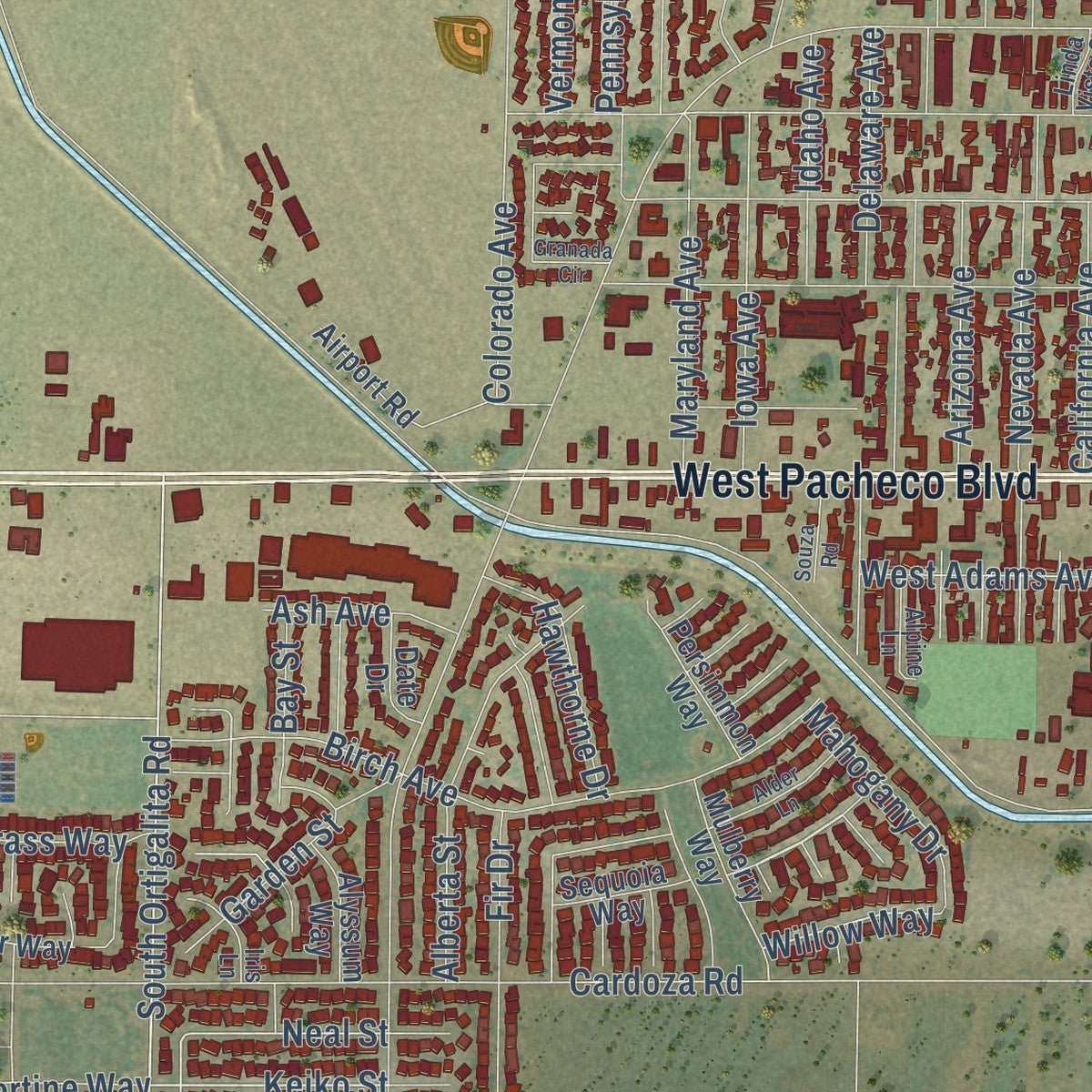
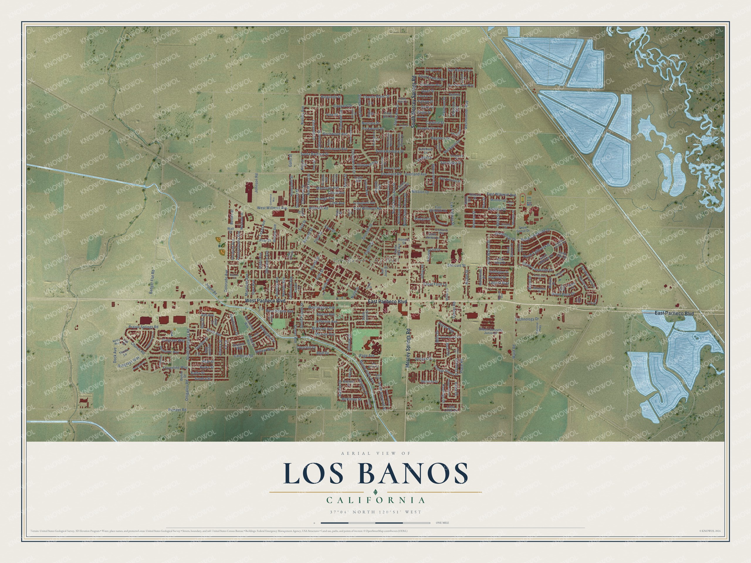
Explore Los Banos, California from a whole new perspective. Created using aerial imagery and detailed geographic data, this map captures Los Banos building by building, with labeled streets, familiar landmarks, and shaded topographical relief that highlights the natural contours of the landscape.
Combining modern data with the timeless character of a vintage atlas, this map is just as interesting up close as it is beautiful on the wall. Whether you grew up in Los Banos, spent memorable years there, or call it home today, this unique map is a great way to celebrate a place that means something to you. Zoom in on the preview to look for your street, and then order a print to put your memories on the wall.
Three ways to hang it

Unframed archival matte, a black wood frame or a white wood frame.
Up close
Geography Worth Displaying
This map was created using accurate cartographic data and authoritative geographic sources, including the U.S. Geological Survey and the Census Bureau. The map brings together terrain, waterways, roads, and building detail. The majority of the streets are labeled, houses are accurately depicted, and the topography is derived from government sources. Combining local data with carefully composed color and shading leads to this beautifully detailed Los Banos artwork for your wall.
Rather than simply showing street outlines, we’ve included as many of the street names as we could reasonably fit on the map while keeping their names legible. Zoom in on the high resolution preview to see exactly what’s on the map. We truly set out to create a statement piece for anyone who loves Los Banos. So whether it’s for you, or a gift for someone you love, we hope this map of Los Banos brings back fond memories.
Read the story behind this map of Los Banos, California from 2026.

Find your street
Names on the Los Banos map
Every name below is printed on this map. Look for your street, your school, the park where you played, or the pond down the road.
Places and landmarks2
- Los Banos City Hall
- Pacheco Park
Streets and roads268
- South Mercey Springs Road
- East Pacheco Boulevard
- West Pacheco Boulevard
- Mercey Springs Road
- North Creekside Drive
- McKinley Street
- Smokey Drive
- Pioneer Road
- Keiko Street
- Wood Duck Drive
- San Diego Street
- South Ortigalita Road
- Bluff Drive
- Burgundy Street
- South Creekside Drive
- North Fallbrook Drive
- Santa Ana Street
- Pitzer Way
- Kathy Street
- Neal Street
- Willow Way
- Seventh Street
- Overland Avenue
- Chestnut Street
- Irvine Drive
- Place Road
- San Luis Street
- Ward Road
- Cardoza Road
- Overland Road
Show all 268 streets
- Stonewood Drive
- Badger Flat Road
- South Eleventh Street
- Ortigalita Road
- East Street
- Center Avenue
- Vineyard Drive
- Colorado Avenue
- North Santa Ana Street
- Mission Drive
- East Willmott Road
- Santa Barbara Street
- Jefferson Avenue
- Madison Avenue
- Page Avenue
- Fairmont Drive
- Canal Farm Lane
- East Willmott Avenue
- Nantes Avenue
- Cabernet Street
- Birch Avenue
- Fourth Street
- Iowa Avenue
- Maryland Avenue
- Illinois Avenue
- Ninth Street
- Adams Avenue
- Washington Avenue
- Prairie Springs Road
- Poppy Lane
- Eighth Street
- Nevada Avenue
- Birchwood Avenue
- Rockport Drive
- Scripps Drive
- Regency Drive
- Santa Barbara Drive
- Park Warren Drive
- Fifth Street
- Citrus Avenue
- North Street
- Arizona Avenue
- Dove Street
- Quail Street
- Palermo Drive
- Travertine Way
- Alberta Street
- Third Street
- Elmwood Drive
- Sixth Street
- Cardinal Street
- Zinfandel Court
- Second Street
- Pine Street
- North First Street
- Westminster Way
- West Willmott Avenue
- Lime Avenue
- Mandarin Avenue
- Fir Drive
- Sandra Street
- Pennsylvania Avenue
- Johnson Road
- Delaware Avenue
- Rainier Drive
- Monte Vista Avenue
- Chenin Blanc Street
- Driftwood Avenue
- Orange Avenue
- Hillview Drive
- Pintail Circle
- Texas Avenue
- North Santa Rosa Street
- Nickel Street
- Willmott Road
- Saint Francis Drive
- Monroe Avenue
- Sunburst Street
- Las Palmas Street
- Hastings Drive
- Greenbriar Drive
- Honeybell Street
- Church Road
- Hawthorne Drive
- California Avenue
- Somerset Avenue
- West Adams Avenue
- Vermont Avenue
- Vine Street
- Oatgrass Way
- Ryegrass Way
- Mahogany Drive
- South Fourth Street
- Idaho Avenue
- San Ramon Lane
- Olivewood Drive
- Garden Street
- Crescent Drive
- Cottonwood Drive
- Technology Drive
- Betten Street
- Louie Avenue
- Dock Avenue
- Heron Drive
- Parkwood Drive
- Ash Avenue
- Bay Street
- Imperial Drive
- Laguna Way
- Davis Drive
- Mills Drive
- Bella Street
- Marsala Street
- Tanner Road
- Ancona Street
- Falcon Street
- Eagle Street
- Gallo Street
- Brant Drive
- Boalt Drive
- First Street
- Pisa Street
- Alps Drive
- Mallard Drive
- Gee Gee Avenue
- Tusky Avenue
- Snow Goose Drive
- Racquet Club Drive
- Berkeley Drive
- South Tenth Street
- College Greens Drive
- Miller Lane
- Santa Rita Avenue
- Gilbert Gonzalez Junior Drive
- San Juan Street
- South Fallbrook Drive
- Santa Maria Street
- Airport Road
- North Santa Rita Street
- Jeffrey Road
- Pinot Noir Street
- San Simeone Way
- Sandhill Crane Drive
- Thistle Lane
- Chamberlain Avenue
- Bellflower Way
- East Willmont Road
- Loma Linda Circle
- Saint James Drive
- El Camino Way
- Friguglietti Avenue
- Oak Street
- Park Sharon Drive
- Bentley Drive
- San Antonio Street
- Everest Street
- Huntington Drive
- Waterford Way
- Park View Drive
- Manchester Drive
- Mulberry Way
- Machado Street
- Watt Drive
- El Cajon Lane
- Persimmon Way
- Chukar Street
- Murano Street
- Alyssum Way
- Montieri Street
- Venezia Street
- Sequoia Way
- Swan Lane
- Sunflower Lane
- Cedar Lake Drive
- Pomelo Avenue
- Date Drive
- Dunite Drive
- Center Lane
- Frank Street
- Romero Street
- Roma Street
- Muscat Street
- Port Street
- Kiwi Street
- Napa Court
- Crystal Springs Drive
- North Santa Clara Street
- Goldeneye Drive
- Ranchwood Drive
- La Vina Circle
- North Santa Monica Street
- North Santa Venetia Street
- North Third Street
- Kensington Circle
- Saint Patricks Drive
- San Lorenzo Street
- Greenbriar Way
- Beechwood Drive
- Tumbleweed Lane
- Pepperdine Drive
- Cedarwood Court
- Santa Lea Street
- Flume Blanc Street
- Industrial Parkway
- Dolomite Court
- Savona Street
- El Pinal Lane
- Greenwich Drive
- Alpine Lane
- Tyler Avenue
- Robin Street
- Vintner Street
- Sprig Way
- Linda Vista Street
- Nettle Way
- Vino Court
- Tenth Street
- Iris Lane
- Saratoga Street
- Granada Circle
- Cobblefield Lane
- Lexington Avenue
- Alder Lane
- South Twelfth Street
- Canvasback Drive
- Heather Creek Drive
- Van Buren Avenue
- Merganser Court
- La Mesa Lane
- Commerce Way
- Souza Road
- Menezes Boulevard
- Merlot Court
- Smokey Court
- Davis Court
- Pecan Court
- Assisi Court
- Via Rosa
Names are listed as they appear on the printed map. Zoom into the product photos to find them.
About Los Banos, California
Los Banos is a city of 45,532 people in Merced County, on the San Joaquin Valley's west side. The name is Spanish, where Los Baños means "the baths," and it comes from a spring that feeds the natural wetlands nearby. Mexican land-grant records show people settling the area in the 1840s, and Uriah Wood became the first Anglo-American settler when he built a two-room cabin in 1859.
The first Los Banos was a trading post several miles from today's downtown, about a mile and a half west of the railroad, close to what is now Volta. A post office opened there in 1873, and the Post Office Department named it for the creek nearby. When the railroad came, the town picked up and moved to the spot where it stands now.
- A race to the land officeSettlers' claims to land and water only counted once a deed was on file. Uriah Wood, who homesteaded off Badger Flat Road, raced cattleman Henry Miller to the land office in Stockton. Once he was across the San Joaquin, Wood handed the ferryman $5 to leave the boat tied up on the east bank, so Miller had no way across. Wood got there first and filed on seven sections at 45¢ an acre.
- Henry Miller's headquartersHenry Miller (1827-1916), at one point in the late 19th century the largest landowner in the United States, ran his Miller & Lux company from Los Banos. His ranch headquarters, set up in 1873, is now the Canal Farm Inn, California Historical Landmark No. 548. Downtown, the 10-acre Henry Miller Plaza honors him with a huge bronze of Miller and his cattle.
- The May Day FairPortuguese, Italian, Spanish and Basque families have long made their homes in Los Banos. Their heritage shows up in local restaurants and in festivals and parades through the year, and the town is known for its May Day Fair, held every year in the first week of May.
- A big league catcherMack Wheat (1893-1979), of Los Banos, was a Major League Baseball catcher with Brooklyn and the Philadelphia Phillies, playing between 1915 and 1921.
Keep exploring California
Los Banos is one of 1,990 California towns we've mapped. Every dot on the map is a print of its own.
The search covers every state, California first.
Near Los Banos
Order 2 or more town maps and save 10%. Shown in the size and finish you picked above, so they hang as a set.
- Volta 12" x 18" / Archival Matte Print $39.99
- Santa Nella 12" x 18" / Archival Matte Print $39.99
- Dos Palos Y 12" x 18" / Archival Matte Print $39.99


More maps nearby: South Dos Palos, Dos Palos, Gustine, Stevinson and El Nido.
The art of mapping a place
How This Map Was Made
Real places. Remarkable detail. Discover the layers that turn geographic data into a map of home.

The view from above
Aerial imagery reveals the character of the land: woodland, open fields, and the patterns of a place.

The shape of the land
Elevation data brings hills, valleys, and subtle changes in the landscape into view.

The details of home
Roads, waterways, and building footprints come together to make the map feel unmistakably local.

Geography becomes art
Considered color, shading, and typography bring the layers together in a map made for your wall.


Process illustrated with Mendon, Massachusetts. Aerial imagery: USDA NAIP. Terrain: USGS 3D Elevation Program. Map details and finished artwork: KNOWOL.
The Details
About This Print
Choose an archival matte print, or a black or white Ayous wood frame. The archival matte print is unframed.
Select your size and finish above to see the matching product image and price.
Materials & Craftsmanship
A contemporary map with the character of a classic atlas, printed on archival matte paper. Optional frames are made from Ayous wood.
Your printed map does not include the watermark shown in the full-map preview.
Shipping & Delivery
Free shipping within the United States. Every print is made to order in the USA.
Buying a gift? Add a note in your cart and we'll include it. We never put prices in the package.
Prints ship within 2 to 3 business days. Allow 7 to 10 days total from ordering for delivery. Timing may vary during holidays or periods of high order volume.
Read our shipping policy.
Returns and damaged prints
Each print is made to order. Change-of-mind refunds are not available after production.
If your print arrives damaged, misprinted or incorrect, contact support@knowol.com within 30 days of receiving it. Include your order number, photos and a description of the issue.
Read our full refund and replacement policy. For questions about your order, email support@knowol.com.