
Search for another town


Free U.S. delivery 7 to 10 days after you order
Maysville, Kentucky Map Art
Building by building, with labeled streets and shaded relief.
12" x 18" Archival Matte Print
A Map of Home. A Work of Art.
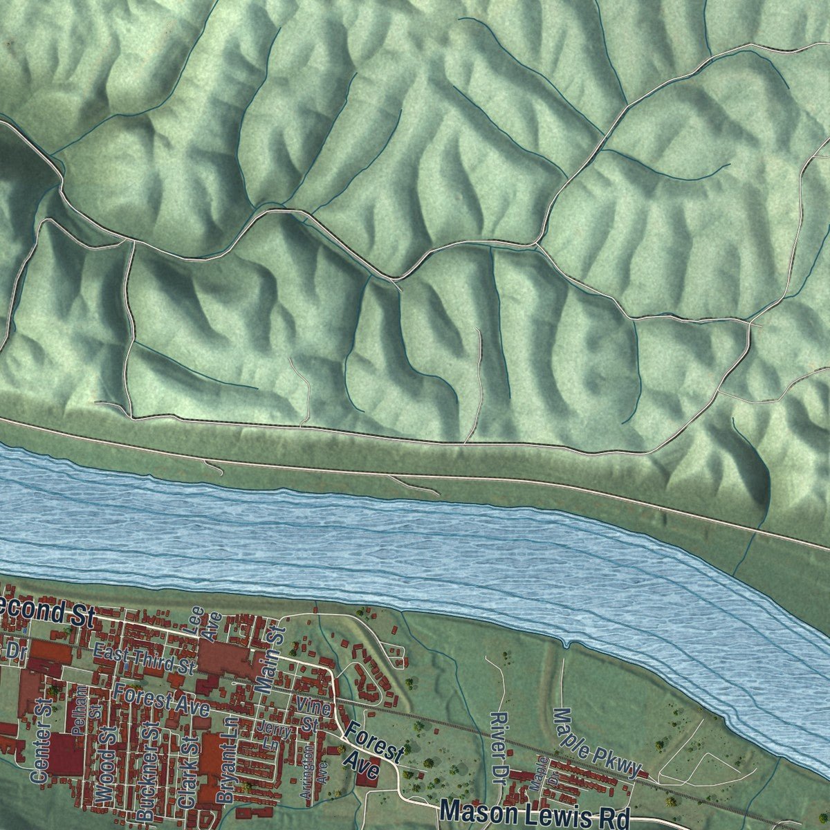
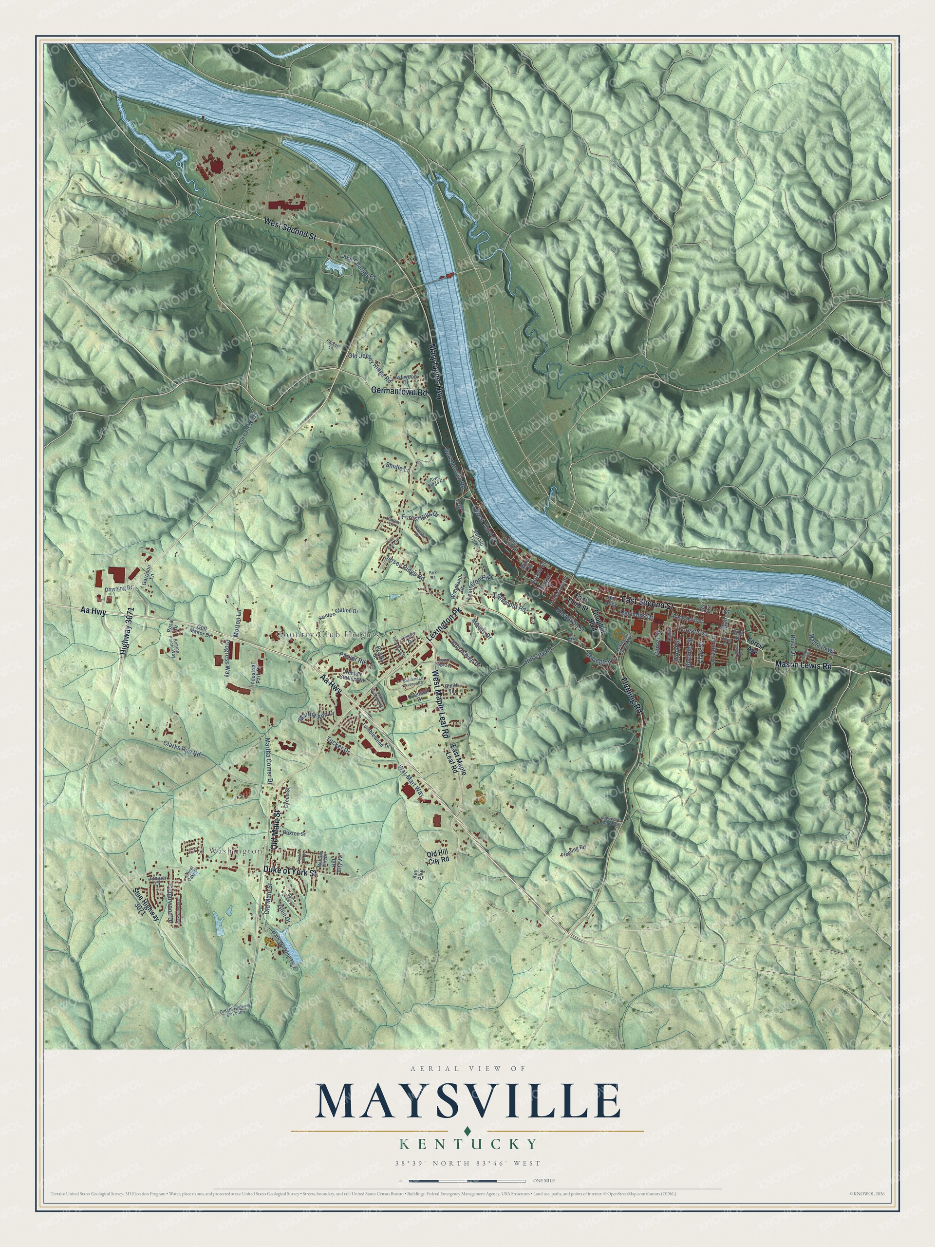
Explore Maysville, Kentucky from a whole new perspective. Created using aerial imagery and detailed geographic data, this map captures Maysville building by building, with labeled streets, familiar landmarks, and shaded topographical relief that highlights the natural contours of the landscape.
Combining modern data with the timeless character of a vintage atlas, this map is just as interesting up close as it is beautiful on the wall. Whether you grew up in Maysville, spent memorable years there, or call it home today, this unique map is a great way to celebrate a place that means something to you. Zoom in on the preview to look for your street, and then order a print to put your memories on the wall.
Three ways to hang it

Unframed archival matte, a black wood frame or a white wood frame.
Up close
Geography Worth Displaying
This map was created using accurate cartographic data and authoritative geographic sources, including the U.S. Geological Survey and the Census Bureau. The map brings together terrain, waterways, roads, and building detail. The majority of the streets are labeled, houses are accurately depicted, and the topography is derived from government sources. Combining local data with carefully composed color and shading leads to this beautifully detailed Maysville artwork for your wall.
Rather than simply showing street outlines, we’ve included as many of the street names as we could reasonably fit on the map while keeping their names legible. Zoom in on the high resolution preview to see exactly what’s on the map. We truly set out to create a statement piece for anyone who loves Maysville. So whether it’s for you, or a gift for someone you love, we hope this map of Maysville brings back fond memories.
Read the story behind this map of Maysville, Kentucky from 2026.

Find your street
Names on the Maysville map
Every name below is printed on this map. Look for your street, your school, the park where you played, or the pond down the road.
Places and landmarks2
- Old Washington
- Country Club Heights
Streets and roads105
- Aa Highway
- Mason Lewis Road
- Lexington Pk
- West Maple Leaf Road
- West Second Street
- Mary Ingles Highway
- East Second Street
- Germantown Road
- Fleming Road
- Old Main Street
- Duke of York Street
- Highway 3071
- Forest Avenue
- Jersey Ridge Road
- Hill City Road
- Clarks Run Road
- West Third Street
- Glen Drive
- Lexington Pike
- Lexington Street
- Maple Parkway
- Martha Comer Drive
- East Sixth Street
- Tucker Drive
- Lake Charles Road
- Edgemont Road
- Parker Road
- Cedarwood Drive
- Progress Way
- Wood Street
Show all 105 streets
- Old Jersey Ridge Road
- Bon Haven Drive
- Morton Lane
- Reynolds Drive
- Wal-Mart Way
- River Drive
- Forest Hills Drive
- Moody Drive
- Martha Ann Drive
- Buckner Street
- Main Street
- Clark Street
- Center Street
- Shidle Lane
- Bryant Lane
- Sutton Street
- East Third Street
- Coughlin Boulevard
- Stae Highway 3071
- Old Hill City Road
- East Maple Leaf Road
- Garrison Lane
- Brooks Street
- Market Street
- Park Walking Trail
- Kenton Station Drive
- Morton Lane North
- Green Street
- Kenton Station Road
- Chenault Drive
- Hall Alley
- Downing Drive
- Woodland Drive
- Buffalo Trce
- Tumbleweed Drive
- Industrial Park Drive
- West Front Street
- Circle Drive
- Ashwood Drive
- Limestone Street
- Paxton Street
- Vine Street
- Lee Avenue
- Golf Manor Drive
- Juniper Drive
- Hill City Vw
- Smith Terrace
- Key Pike
- Wall Street
- Rosa Drive
- Hinton Drive
- Lexington Street Extension
- Old US Highway 68 Loop 2
- Kenton Pointe Way
- Pelham Street
- Navaho Drive
- Pickett Lane
- Bank Street
- Valentine Drive
- Jerry Lane
- Rogers Road
- Mefford Fort Drive
- River Ridge Road
- Lawrence Road Spr
- Laurel Oaks Drive
- Oak Fairway Court
- Glen Circle Drive
- Bus Garage Access Road
- Maple Ridge Avenue
- North Shawnee Road
- Arrington Avenue
- Terre Haute Drive
- Park Drive
- Maple Drive
- Paxton Inn Drive
Names are listed as they appear on the printed map. Zoom into the product photos to find them.
About Maysville, Kentucky
Maysville is a city of 8,873 people and the seat of Mason County, set where Limestone Creek meets the Ohio River. Buffalo crossing the river here wore a trail inland toward the salt licks, and Native Americans used the same path for centuries. Simon Kenton first settled the area in 1775, left to fight in the Revolution, and came back in 1784 to build a blockhouse at the landing, then called Limestone.
John May later acquired the land at the landing, and Daniel Boone kept a trading post and tavern there. The settlement was incorporated as Maysville in 1787, though many people still called it Limestone well into the 19th century. Once the Northwest Indian War ended in 1795, the town began to grow, and by 1807 it ranked as one of Kentucky's two main ports, even with only about sixty dwellings. Steamboats came down the river after 1811, and the town spread quickly.
- Jackson's veto, 1830In 1829 the Kentucky legislature chartered a turnpike company to rebuild the rough old road from Maysville to Lexington, and Henry Clay argued it deserved federal money. Congress agreed in 1830 to buy shares, but President Andrew Jackson, Clay's bitter rival, vetoed the bill as a purely local project. Local backers and private investors paid for it instead, and the turnpike, Kentucky's first macadamized road, was finished in 1835. It is now U.S. Route 68.
- County seat since 1848Washington, the inland village near Kenton's Station, was named the Mason County seat in 1788. By the 1830s Maysville had 3,000 people and trailed only Louisville in Kentucky commerce, while Washington had faded after an 1825 fire and repeated cholera. A bitterly fought vote moved the county government to Maysville in 1848, and the city gave its 1846 city hall to serve as the courthouse. Maysville annexed Washington in 1990.
- Stowe saw an auction, 1833Harriet Beecher Stowe visited in 1833 and watched enslaved people sold at auction in front of the courthouse in Washington, now a historic district of Maysville. She put the scene in Uncle Tom's Cabin, published in 1852. Because free Ohio lay just across the river, people escaping slavery often passed through Maysville on the Underground Railroad.
- Rosemary Clooney's premiereThe Russell Theatre on Third Street, an atmospheric theatre with a rainbow that lit up before and after each film, held the world premiere of The Stars Are Singing, Rosemary Clooney's first movie, in 1953. Clooney started an annual music festival in 1999 to raise money for the theatre's restoration, and in September 2007 the last of Robert Dafford's ten floodwall murals, begun in 1998, was painted in her honor.
Keep exploring Kentucky
Maysville is one of 659 Kentucky towns we've mapped. Every dot on the map is a print of its own.
The search covers every state, Kentucky first.
Near Maysville
Order 2 or more town maps and save 10%. Shown in the size and finish you picked above, so they hang as a set.
- Dover 12" x 18" / Archival Matte Print $39.99
- Germantown 12" x 18" / Archival Matte Print $39.99
- Mays Lick 12" x 18" / Archival Matte Print $39.99


More maps nearby: Sardis, Augusta, Tollesboro, Brooksville and Mount Olivet.
The art of mapping a place
How This Map Was Made
Real places. Remarkable detail. Discover the layers that turn geographic data into a map of home.

The view from above
Aerial imagery reveals the character of the land: woodland, open fields, and the patterns of a place.

The shape of the land
Elevation data brings hills, valleys, and subtle changes in the landscape into view.

The details of home
Roads, waterways, and building footprints come together to make the map feel unmistakably local.

Geography becomes art
Considered color, shading, and typography bring the layers together in a map made for your wall.


Process illustrated with Mendon, Massachusetts. Aerial imagery: USDA NAIP. Terrain: USGS 3D Elevation Program. Map details and finished artwork: KNOWOL.
The Details
About This Print
Choose an archival matte print, or a black or white Ayous wood frame. The archival matte print is unframed.
Select your size and finish above to see the matching product image and price.
Materials & Craftsmanship
A contemporary map with the character of a classic atlas, printed on archival matte paper. Optional frames are made from Ayous wood.
Your printed map does not include the watermark shown in the full-map preview.
Shipping & Delivery
Free shipping within the United States. Every print is made to order in the USA.
Buying a gift? Add a note in your cart and we'll include it. We never put prices in the package.
Prints ship within 2 to 3 business days. Allow 7 to 10 days total from ordering for delivery. Timing may vary during holidays or periods of high order volume.
Read our shipping policy.
Returns and damaged prints
Each print is made to order. Change-of-mind refunds are not available after production.
If your print arrives damaged, misprinted or incorrect, contact support@knowol.com within 30 days of receiving it. Include your order number, photos and a description of the issue.
Read our full refund and replacement policy. For questions about your order, email support@knowol.com.