
Search for another town


Free U.S. delivery 7 to 10 days after you order
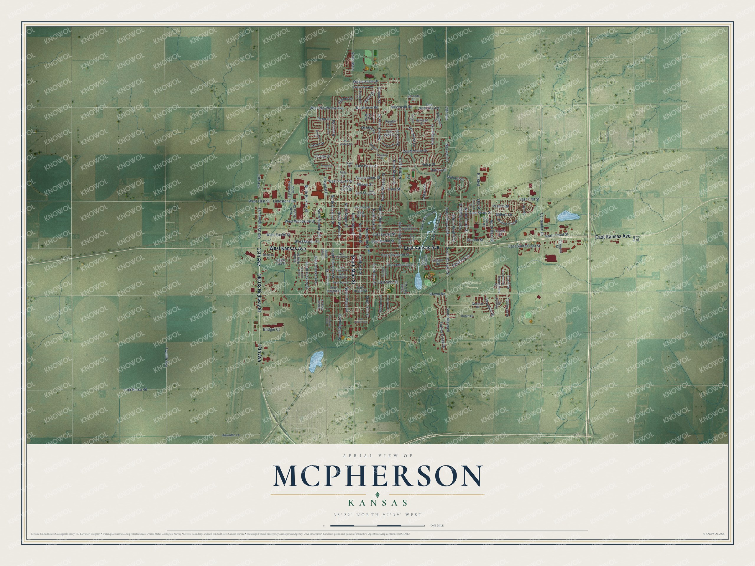
McPherson, Kansas Map Art
Building by building, with labeled streets and shaded relief.
12" x 18" Archival Matte Print
A Map of Home. A Work of Art.
Explore McPherson, Kansas from a whole new perspective. Created using aerial imagery and detailed geographic data, this map captures McPherson building by building, with labeled streets, familiar landmarks, and shaded topographical relief that highlights the natural contours of the landscape.
Combining modern data with the timeless character of a vintage atlas, this map is just as interesting up close as it is beautiful on the wall. Whether you grew up in McPherson, spent memorable years there, or call it home today, this unique map is a great way to celebrate a place that means something to you. Zoom in on the preview to look for your street, and then order a print to put your memories on the wall.
Three ways to hang it

Unframed archival matte, a black wood frame or a white wood frame.
Up close
Geography Worth Displaying
This map was created using accurate cartographic data and authoritative geographic sources, including the U.S. Geological Survey and the Census Bureau. The map brings together terrain, waterways, roads, and building detail. The majority of the streets are labeled, houses are accurately depicted, and the topography is derived from government sources. Combining local data with carefully composed color and shading leads to this beautifully detailed McPherson artwork for your wall.
Rather than simply showing street outlines, we’ve included as many of the street names as we could reasonably fit on the map while keeping their names legible. Zoom in on the high resolution preview to see exactly what’s on the map. We truly set out to create a statement piece for anyone who loves McPherson. So whether it’s for you, or a gift for someone you love, we hope this map of McPherson brings back fond memories.
Read the story behind this map of McPherson, Kansas from 2026.

Find your street
Names on the McPherson map
Every name below is printed on this map. Look for your street, your school, the park where you played, or the pond down the road.
Places and landmarks1
- McPherson Cemetery
Streets and roads158
- East Kansas Avenue
- South Main Street
- 13th Avenue
- Old US Highway 81
- West Kansas Avenue
- North Main Street
- North Walnut Street
- South Walnut Street
- North Main
- Walnut Drive
- South Chestnut Street
- North Chestnut Street
- North Carrie Street
- East Lakeside Drive
- Eastmoor Drive
- Moccasin Road
- North Grimes Street
- South Elm Street
- North Baer Street
- North Hartup Street
- Kiowa Road
- East First Street
- 15th Avenue
- North Maxwell Street
- Maxwell Street
- Northview Road
- North Maple Street
- East Euclid Street
- Centennial Drive
- Limestone Road
Show all 158 streets
- West First Street
- North High Drive
- Twelfth Avenue
- West Euclid Street
- West Woodside Street
- North Elm Street
- Ranch Road
- South Maple Street
- North Ash Street
- South Ash Street
- Darlow Drive
- Sonora Drive
- Iron Horse Road
- South Maxwell
- North Hickory Street
- Turkey Creek Drive
- West Marlin Street
- Hulse Street
- East Marlin Street
- East Elizabeth Street
- South Oak Street
- Penn Drive
- Countryside Drive
- North Wheeler Street
- East South Front Street
- Liberty Drive
- Wickersham Drive
- North Mulberry Street
- East Loomis Street
- South Maxwell Street
- North Cherry Street
- North Oak Street
- Northglen Street
- Gildersleeve Avenue
- South Hickory Street
- North Charles Street
- North Myers Street
- East Seitz Street
- East Sharp Street
- Mallard Drive
- West Northview Avenue
- East Hulse Street
- Gordon Street
- North Olivette Street
- Locust Street
- Briarwood Lane
- Kit Boulevard
- East Hancock Street
- Fox Fire
- Hospital Drive
- Grimes Street
- West Fourth Street
- North Front Street
- Cedars Drive
- Justin Drive
- Stearman Street
- Anna Street
- Millers Lane
- Allison Street
- Eby Street
- Bridger Court
- Prairie Road
- Garden Lane
- Earl Street
- West Lakeside Drive
- East Northview Avenue
- South Park Avenue
- Oak Park Drive
- Sycamore Place
- South Taft Street
- Lyndon Road
- East Hill Street
- South Edna Street
- Smokey Hollow
- Veranda Circle
- Trail West
- West Haight Street
- Crestview Avenue
- Champlin Street
- Oxford Drive
- North Vanguard Street
- Clubhouse Drive
- Sunflower Drive
- Suncrest Drive
- South Lakeside
- North Cedar Street
- Euclid Street
- Heritage Drive
- Thunderbird Street
- Hiawatha Lane
- South Pine Court
- Randolf Drive
- Genesis Drive
- Lake Road
- South Kelly Street
- West Third Street
- East Haight Street
- Robin Drive
- 17th Avenue
- Fifth Street
- East Simpson Street
- Dover Road
- South Fisher Street
- Oaklane Street
- North Lehmer Street
- East Olive Street
- West Seitz Street
- West Bishop Street
- McKinley Street
- Dull Knife Street
- Oakmont Street
- Cottonwood
- South Lucy Avenue
- Deerfield Road
- East Earl Street
- Sixth Street
- West Skancke Street
- West Elizabeth Street
- Eshelman Street
- Heritage Place
- Westwood Drive
- Trail North
- West National Avenue
- North Park Avenue
- East Avenue East
- South Central Avenue
- Normandy Road
- Ponderosa Court
Names are listed as they appear on the printed map. Zoom into the product photos to find them.
About McPherson, Kansas
McPherson is a city of 14,082 people and the county seat of McPherson County, and it carries the name of the Union general James Birdseye McPherson. In June 1872 L. G. Skancke, chief clerk at the Salina land office, heard that a colony of Kentuckians meant to settle the McPherson Flats, so he picked a town site in their center. On June 4, 1872, he and three friends left Salina at 4 a.m. in an old stage, which tipped over while fording the Smoky Hill River near Lindsborg. They dried off, picked up two more men at Point Creek, and measured their way south by tying a handkerchief to a wheel and counting its turns.
At noon they reached the spot, called it McPherson Center and formed a town company with James Marlin as president. That July the company took in rival town builders from King City, its board grew from six directors to twelve, and H. Bowker put up the first building, a store. A post office opened in April 1873 with C. L. Raff as postmaster. The town grew so fast that it became a city on March 4, 1874, and on March 16 about thirty voters elected Sol. Stephens mayor. By 1888 McPherson stood where four rail lines met.
- Olympic gold in 1936The local refinery sponsored the McPherson Globe Refiners, an AAU team coached by Gene Johnson and known for tall centers Joe Fortenberry and Willard Schmidt. The Refiners beat Hollywood Universal for the 1936 AAU national title, and players from both teams made up the first U.S. Olympic basketball squad. On August 14, 1936, the Refiners' players beat Canada 19 to 8 for the gold. Their home court, the McPherson Community Building, joined the National Register in 2018.
- 200,000 gallons a dayOil turned up in McPherson County in the late 1920s, and the Globe Oil & Refining Company, part of Lario Oil & Gas, built a refinery in McPherson in 1933. It was soon turning out 200,000 gallons of gasoline a day. To sell all that fuel, Lario paid for amateur basketball teams, which put its name on newspaper sports pages.
- The county treasury robberyThe county had no safe, so H. Bowker kept its money at his house. On March 1, 1875, a committee found the deputy treasurer's books behind and gave him until morning to finish them. That night someone entered Bowker's house and took $3,300 in county funds. Eight days later H. and C. B. Bowker were examined and charged with the robbery, but people saw the case as malicious, and no damaging evidence was ever produced.
- A diamond claim in 1926At McPherson College in 1926, Dr. J. Willard Hershey repeated experiments other scientists had done and announced that he had made a synthetic diamond, which would have put him among the first to do it. Later experimenters could not get the same result, and that cast doubt on his claim.
- Airplanes built in McPhersonFrom 1964 to 1967 the Alon company built 245 Alon Aircoupes, small two-seat planes, at McPherson. The design came from the ERCO Ercoupe of the late 1930s, and the company's name joined those of John Allen and Al Higdon, the Beech Aircraft executives who started it. Alon later sold out to Mooney Aircraft, which moved the work to Kerrville, Texas.
Keep exploring Kansas
McPherson is one of 764 Kansas towns we've mapped. Every dot on the map is a print of its own.
The search covers every state, Kansas first.
Near McPherson
Order 2 or more town maps and save 10%. Shown in the size and finish you picked above, so they hang as a set.
- Elyria 12" x 18" / Archival Matte Print $39.99
- Galva 12" x 18" / Archival Matte Print $39.99
- Inman 12" x 18" / Archival Matte Print $39.99


More maps nearby: Canton, Windom, Moundridge, Lindsborg and Marquette.
The art of mapping a place
How This Map Was Made
Real places. Remarkable detail. Discover the layers that turn geographic data into a map of home.

The view from above
Aerial imagery reveals the character of the land: woodland, open fields, and the patterns of a place.

The shape of the land
Elevation data brings hills, valleys, and subtle changes in the landscape into view.

The details of home
Roads, waterways, and building footprints come together to make the map feel unmistakably local.

Geography becomes art
Considered color, shading, and typography bring the layers together in a map made for your wall.


Process illustrated with Mendon, Massachusetts. Aerial imagery: USDA NAIP. Terrain: USGS 3D Elevation Program. Map details and finished artwork: KNOWOL.
The Details
About This Print
Choose an archival matte print, or a black or white Ayous wood frame. The archival matte print is unframed.
Select your size and finish above to see the matching product image and price.
Materials & Craftsmanship
A contemporary map with the character of a classic atlas, printed on archival matte paper. Optional frames are made from Ayous wood.
Your printed map does not include the watermark shown in the full-map preview.
Shipping & Delivery
Free shipping within the United States. Every print is made to order in the USA.
Buying a gift? Add a note in your cart and we'll include it. We never put prices in the package.
Prints ship within 2 to 3 business days. Allow 7 to 10 days total from ordering for delivery. Timing may vary during holidays or periods of high order volume.
Read our shipping policy.
Returns and damaged prints
Each print is made to order. Change-of-mind refunds are not available after production.
If your print arrives damaged, misprinted or incorrect, contact support@knowol.com within 30 days of receiving it. Include your order number, photos and a description of the issue.
Read our full refund and replacement policy. For questions about your order, email support@knowol.com.