
Search for another town


Free U.S. delivery 7 to 10 days after you order
Mebane, North Carolina Map Art
Building by building, with labeled streets and shaded relief.
12" x 18" Archival Matte Print
A Map of Home. A Work of Art.
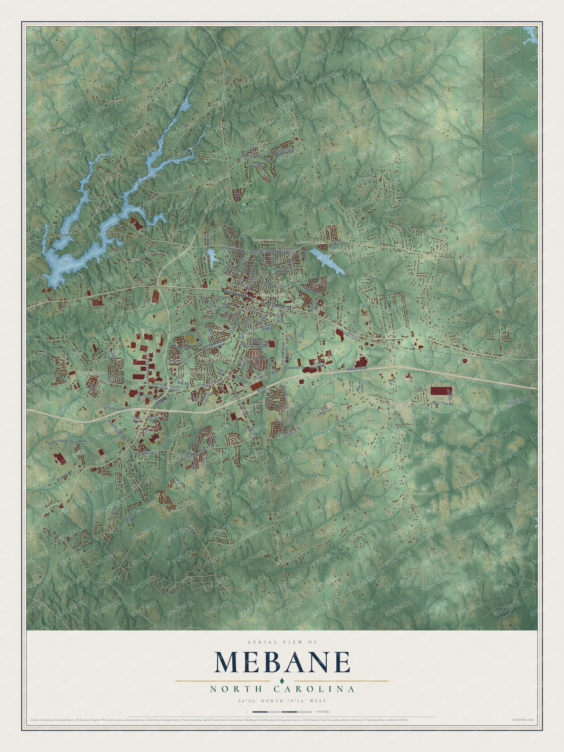
Explore Mebane, North Carolina from a whole new perspective. Created using aerial imagery and detailed geographic data, this map captures Mebane building by building, with labeled streets, familiar landmarks, and shaded topographical relief that highlights the natural contours of the landscape.
Combining modern data with the timeless character of a vintage atlas, this map is just as interesting up close as it is beautiful on the wall. Whether you grew up in Mebane, spent memorable years there, or call it home today, this unique map is a great way to celebrate a place that means something to you. Zoom in on the preview to look for your street, and then order a print to put your memories on the wall.
Three ways to hang it

Unframed archival matte, a black wood frame or a white wood frame.
Up close
Geography Worth Displaying
This map was created using accurate cartographic data and authoritative geographic sources, including the U.S. Geological Survey and the Census Bureau. The map brings together terrain, waterways, roads, and building detail. The majority of the streets are labeled, houses are accurately depicted, and the topography is derived from government sources. Combining local data with carefully composed color and shading leads to this beautifully detailed Mebane artwork for your wall.
Rather than simply showing street outlines, we’ve included as many of the street names as we could reasonably fit on the map while keeping their names legible. Zoom in on the high resolution preview to see exactly what’s on the map. We truly set out to create a statement piece for anyone who loves Mebane. So whether it’s for you, or a gift for someone you love, we hope this map of Mebane brings back fond memories.
Read the story behind this map of Mebane, North Carolina from 2026.

Find your street
Names on the Mebane map
Every name below is printed on this map. Look for your street, your school, the park where you played, or the pond down the road.
Places and landmarks9
- Mebane City Hall
- Sunset Ridge
- Brook Hollow
- Cheeks Crossroads
- Florence Town
- Stagecoach Trail
- Buena Vista Estates
- Lakeview Acres
- Mill Creek
Streets and roads106
- East Center Street
- West Center Street
- State Road 1962
- State Road 1996
- North Ninth Street
- East Brown Street
- Foust Road
- South Fifth Street
- North First Street
- Oakwood Street
- North Fifth Street
- State Road 2200
- Mebane Oaks Road
- Cedar Lane
- State Road 1144
- Sentor Ralph Scott Parkway
- West Ten Road
- Saint Andrews Drive
- South Eighth Street
- State Road 2126
- State Road 1981
- North Carr Street
- Ben Wilson Road
- Arrowhead Boulevard
- Briarwood Drive
- Bowman Road
- Blue Lake Drive
- Corporate Park Drive
- Avalon Drive
- North Third Street
Show all 106 streets
- Gregory Poole Lane
- Longleaf Pine Place
- Industrial Drive
- Corregidor Street
- Mrs White Lane
- Maple Lane
- Kimrey Road
- Giles Street
- Farrell Road
- Hill Lane
- State Road 1306
- South Third Street Extension
- Lebanon Road
- West Stagecoach Road
- State Road 1376
- South Tenth Street
- Oakwood Street Extended
- State Road 1992
- State Road 1140
- State Road 1301
- West Lee Street
- Copper Circle
- Mebane Airport Road
- Hudson Drive
- Ashbury Boulevard
- Fairhaven Drive
- Enterprise Lane
- Brockton Drive
- Southwick Place
- Wilson Road
- East Webb Street
- Pebble Beach Drive
- Turner Road
- Pear Tree Lane
- Yellow Wood Drive
- Lowes Boulevard
- Brinkley Circle
- Falcon Lane
- Jones Drive
- South Third Street
- Hunters Run Road
- State Road 1007
- Great Smokey Mountain Drive
- Old Hillsborough Road
- South Third Street Extended
- State Road 1922
- State Road 1142
- North Wilba Road
- Bluebird Lane
- State Road 1303
- South First Street
- Torrey Pines Court
- Hope Allison Road
- Retriever Lane
- Lysander Lane
- Birkdale Drive
- Olympic Drive
- Rabbit Run
- North Street
- Kit Lane
- Collington Drive
- West Holt Street
- Birkdale Circle
- Sam Snead Drive
- London Lane
- Applecross Drive
- Audrey Garrett Drive
- Spring Forest Drive
- Dogwood Way
- Hastings Boulevard
- South Fifth Street Extension
- Five Pine Court
- Quaker Creek Drive
- Colonial Way
- Heath Lane
- Sun Ray Lane
Names are listed as they appear on the printed map. Zoom into the product photos to find them.
About Mebane, North Carolina
Mebane is a city of 17,797 people. Most of it lies in Alamance County, and two small slivers on its east side are in Orange County. The Mebane family gave the place its name. Giles Mebane, a lawyer, farmer and legislator, was born near the present town, and Wikipedia says the town honors Brigadier General Alexander Mebane, a Revolutionary War officer who later served in Congress.
The town was incorporated in 1881 under the name Mebanesville. Two years later, in 1883, the name was shortened to Mebane, and in 1987 the town was incorporated as a city.
- A mural painted twiceIn 1939, under the New Deal, Margaret C. Gates won a Treasury Department contest to paint a mural for the Mebane post office. Her tobacco curing scene, hung in 1941, showed a man and a young boy walking to work on a tobacco farm. When the post office was remodeled in 1965, officials tried to remove the mural for restoration and ruined it. Local artist Henry E. Rood III painted an exact copy for the new building.
- The Alamance town in 919Mebane's phones started in 704, then North Carolina's only area code, and moved to 919 when that code arrived in 1954. When the Triad got its own code, 910, in 1993, Mebane stayed in 919 so the whole city would keep one code. It stayed there after the Triad moved to 336 in 1998, so most Mebane numbers still differ from the rest of Alamance County.
- A long fight over NC 119The state planned for years to move North Carolina Highway 119 off its route through downtown and onto a new path farther west. Residents of mostly African American neighborhoods along that path, joined by the West End Revitalization Association, filed civil rights complaints against the state and the city. The project was halted for four years starting in 1999, and federal highway officials finally approved it in December 2009.
Keep exploring North Carolina
Mebane is one of 952 North Carolina towns we've mapped. Every dot on the map is a print of its own.
The search covers every state, North Carolina first.
Near Mebane
Order 2 or more town maps and save 10%. Shown in the size and finish you picked above, so they hang as a set.
- Hawfields 12" x 18" / Archival Matte Print $39.99
- Woodlawn 12" x 18" / Archival Matte Print $39.99
- Haw River 12" x 18" / Archival Matte Print $39.99


More maps nearby: Green Level, Swepsonville, Efland, Graham and Pleasant Grove.
The art of mapping a place
How This Map Was Made
Real places. Remarkable detail. Discover the layers that turn geographic data into a map of home.

The view from above
Aerial imagery reveals the character of the land: woodland, open fields, and the patterns of a place.

The shape of the land
Elevation data brings hills, valleys, and subtle changes in the landscape into view.

The details of home
Roads, waterways, and building footprints come together to make the map feel unmistakably local.

Geography becomes art
Considered color, shading, and typography bring the layers together in a map made for your wall.


Process illustrated with Mendon, Massachusetts. Aerial imagery: USDA NAIP. Terrain: USGS 3D Elevation Program. Map details and finished artwork: KNOWOL.
The Details
About This Print
Choose an archival matte print, or a black or white Ayous wood frame. The archival matte print is unframed.
Select your size and finish above to see the matching product image and price.
Materials & Craftsmanship
A contemporary map with the character of a classic atlas, printed on archival matte paper. Optional frames are made from Ayous wood.
Your printed map does not include the watermark shown in the full-map preview.
Shipping & Delivery
Free shipping within the United States. Every print is made to order in the USA.
Buying a gift? Add a note in your cart and we'll include it. We never put prices in the package.
Prints ship within 2 to 3 business days. Allow 7 to 10 days total from ordering for delivery. Timing may vary during holidays or periods of high order volume.
Read our shipping policy.
Returns and damaged prints
Each print is made to order. Change-of-mind refunds are not available after production.
If your print arrives damaged, misprinted or incorrect, contact support@knowol.com within 30 days of receiving it. Include your order number, photos and a description of the issue.
Read our full refund and replacement policy. For questions about your order, email support@knowol.com.