
Search for another town


Free U.S. delivery 7 to 10 days after you order
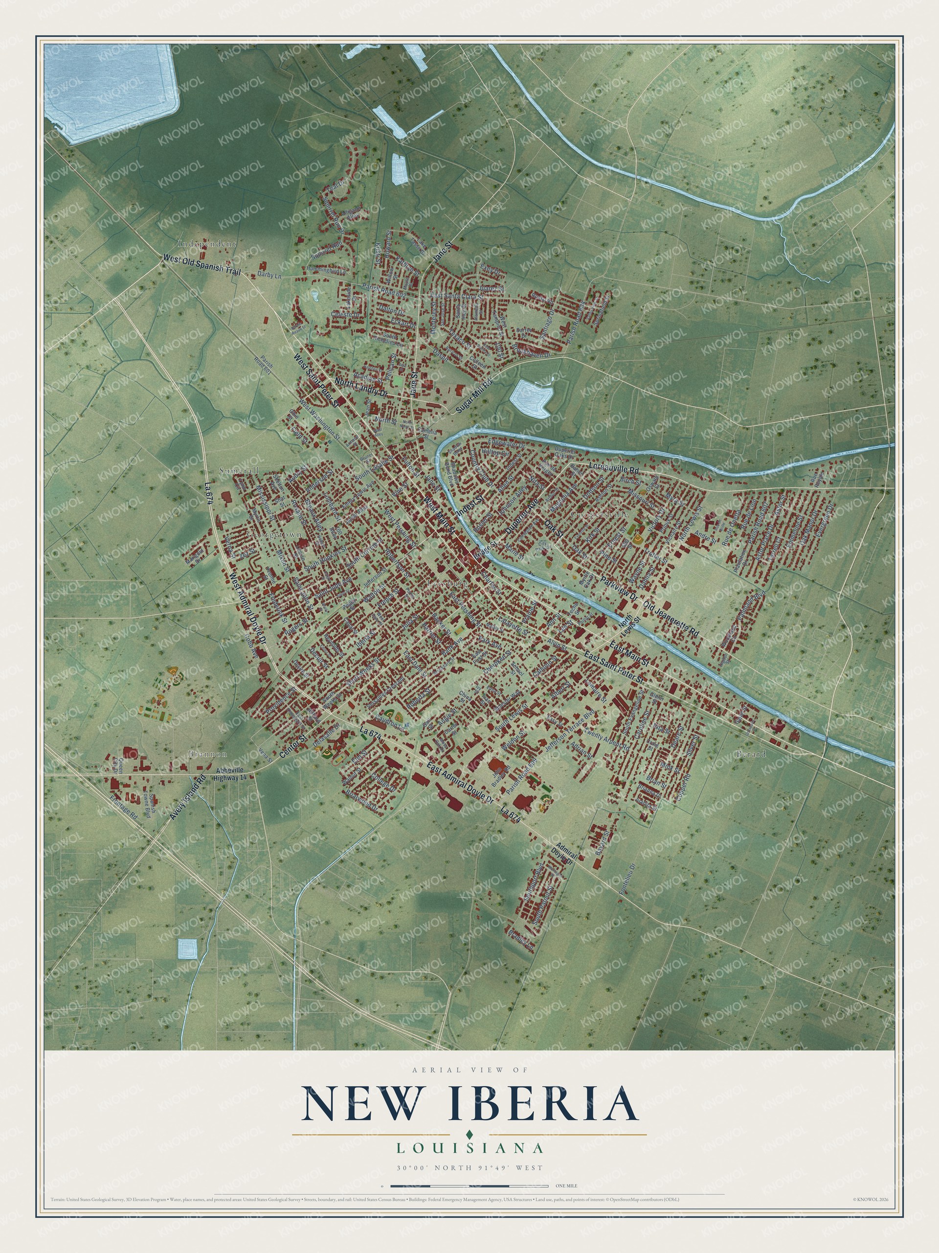
New Iberia, Louisiana Map Art
Building by building, with labeled streets and shaded relief.
12" x 18" Archival Matte Print
A Map of Home. A Work of Art.
Explore New Iberia, Louisiana from a whole new perspective. Created using aerial imagery and detailed geographic data, this map captures New Iberia building by building, with labeled streets, familiar landmarks, and shaded topographical relief that highlights the natural contours of the landscape.
Combining modern data with the timeless character of a vintage atlas, this map is just as interesting up close as it is beautiful on the wall. Whether you grew up in New Iberia, spent memorable years there, or call it home today, this unique map is a great way to celebrate a place that means something to you. Zoom in on the preview to look for your street, and then order a print to put your memories on the wall.
Three ways to hang it

Unframed archival matte, a black wood frame or a white wood frame.
Up close
Geography Worth Displaying
This map was created using accurate cartographic data and authoritative geographic sources, including the U.S. Geological Survey and the Census Bureau. The map brings together terrain, waterways, roads, and building detail. The majority of the streets are labeled, houses are accurately depicted, and the topography is derived from government sources. Combining local data with carefully composed color and shading leads to this beautifully detailed New Iberia artwork for your wall.
Rather than simply showing street outlines, we’ve included as many of the street names as we could reasonably fit on the map while keeping their names legible. Zoom in on the high resolution preview to see exactly what’s on the map. We truly set out to create a statement piece for anyone who loves New Iberia. So whether it’s for you, or a gift for someone you love, we hope this map of New Iberia brings back fond memories.
Read the story behind this map of New Iberia, Louisiana from 2026.

Find your street
Names on the New Iberia map
Every name below is printed on this map. Look for your street, your school, the park where you played, or the pond down the road.
Places and landmarks7
- Brannon
- Berard
- Coopersville
- Georgetown
- Independent
- Leesburg
- Sumerall
Streets and roads253
- East Main Street
- West Main Street
- Parkview Drive
- La 674
- West Old Spanish Trail
- Duperier Avenue
- West Admiral Doyle Drive
- East Admiral Doyle Drive
- Loreauville Road
- Indest Street
- Sugar Mill Road
- North Landry Drive
- Center Street
- East Saint Peter Street
- West Saint Peter Street
- Jane Street
- Avery Island Road
- Old Jeanerette Road
- Oak Street
- West Washington Street
- Iberia Street
- South Lewis Street
- Julia Street
- West Pershing Street
- Kirk Street
- Edgewater Drive
- South Patout Street
- Saint John Street
- Prairie Street
- Jefferson Terrace Boulevard
Show all 253 streets
- Parish Road 609
- Frontage Road
- Fulton Street
- Fontelieu Drive
- Daspit
- Parish Road 604
- Field Street
- South Hopkins Street
- Bank Avenue
- Bayard Street
- East Dale Street
- Ann Street
- French Street
- Anderson Street
- Saint Jude Avenue
- Short Weeks Street
- Darby Lane
- Parish Road 602
- Weldon Street
- Twenty Arpent Road
- Providence Street
- South Corrine Street
- East Santa Clara Street
- Lombard Street
- Walton Street
- East Pershing Street
- Trotter Street
- Charles Street
- North Lewis Street
- Park Avenue
- Cherokee Street
- Squirrel Run
- Southport Boulevard
- Caroline Street
- Squirrel Run Drive
- Mississippi Street
- Victory Drive
- Texaco Street
- Terrell Court
- Robertson Street
- Hacker Street
- Deare Street
- South Lasalle Street
- Marie Street
- Palmland Boulevard
- Dodson Street
- Astor Place Drive
- Astor Street
- Evergreen Drive
- Juarez Street
- Lee Street
- Delasalle Drive
- Parish Road 607
- Emmeline Street
- Myra Street
- Oak Manor Drive
- Adrian Street
- Mixon Street
- Alvin Street
- Hilltop Circle
- Magnolia Avenue
- Copper Road
- Silver Street
- Frederick Street
- Johnson Alley
- Teal Drive
- Allen Street
- Elm Street
- Rosalie Street
- Rosier Street
- Pine Street
- Breaux Alley
- Monterey Street
- Rue de Lion
- Howard Street
- Celeste Drive
- Ernest Street
- Santiago Drive
- Missouri Street
- Rue de Onetta
- Country Club Drive
- Birch Street
- Caudron Lane
- Brian Street
- Acadian Street
- Calhoun Street
- Andre Street
- Kathryn Street
- Roberta Street
- Briarwood Drive
- North Street
- Albert Street
- Lafayette Street
- Lemaire Street
- Brookhaven Drive
- Pelican Street
- Angie Street
- Dahlia Street
- Wayne Street
- Dalton Drive
- Eckart Drive
- College Drive
- Vine Street
- Rogers Street
- Verna Street
- Harriet Street
- Zez Street
- Nita Street
- Kristi Street
- Mink Street
- Cobb Avenue
- Decuir Street
- Bradley Lane
- Exey Drive
- Rita Street
- Audry Street
- 100 Street
- Bridge Street
- Abbeville Highway 14
- Admiral Doyle Drive
- Parish Road 601
- Lynn Circle
- South Weeks Street
- South Evangeline Street
- Ashton Street
- Plantation Drive
- Hummingbird Lane
- Shadows Bend Boulevard
- Vicnaire Street
- Prioux Street
- Myrtis Street
- Santa Inez Street
- Emery Lewis Avenue
- Versailles Crescent
- Walnut Street
- Spanish Towne Boulevard
- Yvonne Street
- Lake Tasse Drive
- Dartez Drive
- East First Street
- Russo Road
- Jefferson Street
- Woodland Circle
- John Bradley Road
- South Richelieu Circle
- Duperier Oaks Drive
- West Tampico Street
- Jacob Alley
- Oswald Street
- Obie Street
- Shlester Way
- Carter Street
- Springfield Street
- Camelia Street
- Lakeside Drive
- Easy Street
- Louise Street
- Marigold Drive
- Reynolds Street
- Ivan Street
- Gajan Street
- Shot Street
- Willow Street
- Alligator Alley
- Gail Street
- Shelton Avenue
- Bahon Street
- Hilliard Street
- Brianna Drive
- School Street
- 500 Street
- Peggy Street
- Queen City Drive
- Juanita Street
- Colleen Street
- Glenn Street
- Desire Street
- Rue de Verger
- Vena Street
- Jean Street
- Canal Street
- Teche Street
- Rue Royale
- Myrtle Oak Drive
- China Street
- Craig Street
- 700 Alley
- West Dale Street
- Hebert Street
- Broussard Street
- City Park Circle
- Alameda Street
- San Jose Street
- Malain Street
- Constance Avenue
- East Thompson Street
- Porter Street
- Edna Street
- Arthur Street
- Apricot Street
- Shadow Bend
- Maple Street
- Phillip Street
- Moss Oak Drive
- Armand Street
- Higdon Street
- Bruner Street
- Ivy Street
- Montagne Street
- Everette Street
- Eden Street
- Daigre Street
- Halphen Street
- Barbin Reaux Street
- Rouly Street
- Emma Street
- Spell Alley
- Rue de Brille
- Valley View Street
- East Saltilla Street
- Gonsoulin Street
- North North Street
- Sere Street
Names are listed as they appear on the printed map. Zoom into the product photos to find them.
About New Iberia, Louisiana
New Iberia is a city of 28,555 people on Bayou Teche, and it is the parish seat of Iberia Parish. In the spring of 1779, Governor Galvez sent Lieutenant Colonel Francisco Bouligny up the bayou with nearly 500 colonists from Spain and the Canary Islands. They settled near the lake later called Spanish Lake and named their new home for the Iberian Peninsula they had left behind.
The name changed with each new group of settlers. French speakers said Nouvelle Ibérie, and postmarks from 1802 read Nova Iberia. English speakers who came after the Louisiana Purchase simply called it New Town. A post office opened in 1814 under the name New Iberia. The town was laid out in 1835 and incorporated in 1839 as the Town of Iberia. In 1847 the legislature amended its charter and made New Iberia the official name.
- Parish seat since 1868The town belonged to St. Martin Parish until Iberia Parish was created in 1868 with New Iberia as its seat. At first the court met in rented space, and a temporary courthouse burned in 1870. A new courthouse costing $22,000 opened downtown in 1884, on the spot that is now Bouligny Plaza. It served until 1940, when the present courthouse was built on Iberia Street.
- Sugar first, rice secondAn old parish history named sugar as the main crop around New Iberia, with rice in second place. In town it found 3 banks and 3 large sawmills, along with several foundries, a shipyard, a cottonseed oil mill and a brick factory, while the Southern Pacific and the bayou carried goods to market. The Conrad Rice Mill has run since 1912, joined the National Register in 1982 and still offers tours.
- The Sugar Cane FestivalEvery September the Louisiana Sugar Cane Festival marks the start of the cane harvest, which people here call grinding. El Festival Español de Nueva Iberia honors the Spanish founders. The World Championship Gumbo Cook-Off takes over the second full weekend in October.
- Home of Dave RobicheauxNovelist James Lee Burke made New Iberia the home of his detective Dave Robicheaux, and Burke lives here too. In the Electric Mist, a film based on one of his novels and starring Tommy Lee Jones, was shot in town in 2009. Each April the Books Along the Teche Literary Festival celebrates his work.
Keep exploring Louisiana
New Iberia is one of 594 Louisiana towns we've mapped. Every dot on the map is a print of its own.
The search covers every state, Louisiana first.
Near New Iberia
Order 2 or more town maps and save 10%. Shown in the size and finish you picked above, so they hang as a set.
- Daspit 12" x 18" / Archival Matte Print $39.99
- Pesson 12" x 18" / Archival Matte Print $39.99
- Belle Place 12" x 18" / Archival Matte Print $39.99


More maps nearby: Lydia, Loreauville, Coteau, Cade and St. Martinville.
The art of mapping a place
How This Map Was Made
Real places. Remarkable detail. Discover the layers that turn geographic data into a map of home.

The view from above
Aerial imagery reveals the character of the land: woodland, open fields, and the patterns of a place.

The shape of the land
Elevation data brings hills, valleys, and subtle changes in the landscape into view.

The details of home
Roads, waterways, and building footprints come together to make the map feel unmistakably local.

Geography becomes art
Considered color, shading, and typography bring the layers together in a map made for your wall.


Process illustrated with Mendon, Massachusetts. Aerial imagery: USDA NAIP. Terrain: USGS 3D Elevation Program. Map details and finished artwork: KNOWOL.
The Details
About This Print
Choose an archival matte print, or a black or white Ayous wood frame. The archival matte print is unframed.
Select your size and finish above to see the matching product image and price.
Materials & Craftsmanship
A contemporary map with the character of a classic atlas, printed on archival matte paper. Optional frames are made from Ayous wood.
Your printed map does not include the watermark shown in the full-map preview.
Shipping & Delivery
Free shipping within the United States. Every print is made to order in the USA.
Buying a gift? Add a note in your cart and we'll include it. We never put prices in the package.
Prints ship within 2 to 3 business days. Allow 7 to 10 days total from ordering for delivery. Timing may vary during holidays or periods of high order volume.
Read our shipping policy.
Returns and damaged prints
Each print is made to order. Change-of-mind refunds are not available after production.
If your print arrives damaged, misprinted or incorrect, contact support@knowol.com within 30 days of receiving it. Include your order number, photos and a description of the issue.
Read our full refund and replacement policy. For questions about your order, email support@knowol.com.