
Search for another town


Free U.S. delivery 7 to 10 days after you order
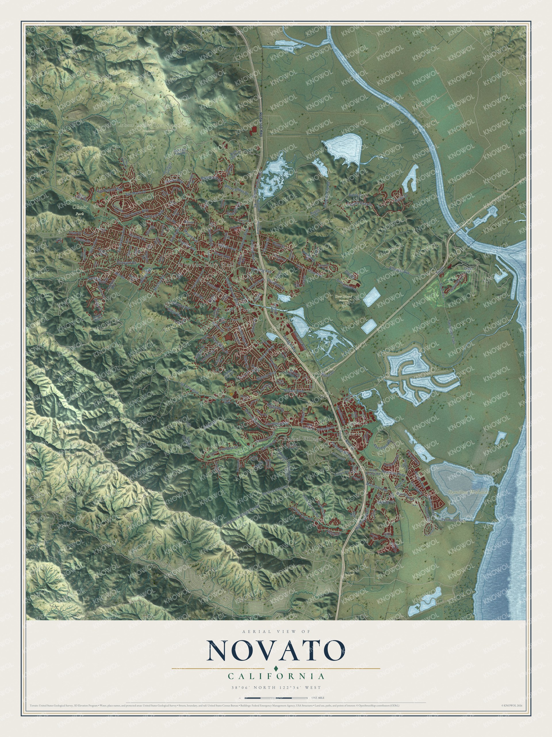
Novato, California Map Art
Building by building, with labeled streets and shaded relief.
12" x 18" Archival Matte Print
A Map of Home. A Work of Art.
Explore Novato, California from a whole new perspective. Created using aerial imagery and detailed geographic data, this map captures Novato building by building, with labeled streets, familiar landmarks, and shaded topographical relief that highlights the natural contours of the landscape.
Combining modern data with the timeless character of a vintage atlas, this map is just as interesting up close as it is beautiful on the wall. Whether you grew up in Novato, spent memorable years there, or call it home today, this unique map is a great way to celebrate a place that means something to you. Zoom in on the preview to look for your street, and then order a print to put your memories on the wall.
Three ways to hang it

Unframed archival matte, a black wood frame or a white wood frame.
Up close
Geography Worth Displaying
This map was created using accurate cartographic data and authoritative geographic sources, including the U.S. Geological Survey and the Census Bureau. The map brings together terrain, waterways, roads, and building detail. The majority of the streets are labeled, houses are accurately depicted, and the topography is derived from government sources. Combining local data with carefully composed color and shading leads to this beautifully detailed Novato artwork for your wall.
Rather than simply showing street outlines, we’ve included as many of the street names as we could reasonably fit on the map while keeping their names legible. Zoom in on the high resolution preview to see exactly what’s on the map. We truly set out to create a statement piece for anyone who loves Novato. So whether it’s for you, or a gift for someone you love, we hope this map of Novato brings back fond memories.
Read the story behind this map of Novato, California from 2026.

Find your street
Names on the Novato map
Every name below is printed on this map. Look for your street, your school, the park where you played, or the pond down the road.
Places and landmarks9
- Novato City Hall
- Dewitt
- Rafael Village
- Deer Island Preserve
- Hamilton Wetlands
- Mount Burdell Open Space Preserve
- Ohair Park
- Old Town
- Ignacio
Streets and roads213
- De Long Avenue
- Ignacio Boulevard
- Plata Court
- Redwood Boulevard
- Novato Boulevard
- Center Road
- Alameda del Prado
- San Marin Drive
- South Novato Boulevard
- Fairway Drive
- Rowland Boulevard
- Olive Avenue
- San Carlos Way
- Nave Drive
- Marin Valley Drive
- Atherton Avenue
- Big Rock Ridge Fire Road
- Eagle Drive
- Cambridge Street
- Vineyard Road
- Hamilton Parkway
- Aberdeen Road
- Bolling Circle
- Simmons Lane
- Sunset Parkway
- Bahia Drive
- Sutro Avenue
- Grant Avenue
- Hill Road
- Laguna Vista Drive
Show all 213 streets
- Wilson Avenue
- Santa Maria Drive
- Twowater Trail
- San Luis Way
- Seventh Street
- McClay Road
- West Campus Drive
- Highland Drive
- San Ramon Way
- Stonetree Lane
- Pinheiro Fire Road
- Perimeter Road
- Marion Avenue
- Topaz Drive
- Vintage Way
- Hangar Avenue
- Laurelwood Drive
- Canyon Road
- Calienta Real
- Midway Boulevard
- Marin Oaks Drive
- Garner Drive
- Mill Road
- Vallejo Avenue
- Hamilton Drive
- Railroad Avenue
- Washington Street
- Deer Island Lane
- Eucalyptus Avenue
- Arthur Street
- Sunset Drive
- Palm Drive
- Grande Vis
- Capilano Drive
- Rush Landing Road
- Main Gate Road
- Ridge Road
- Little Cat Fire Road
- Palmer Drive
- Davidson Street
- Butterfield Drive
- Plum Street
- Truman Drive
- Lea Drive
- Virginia Avenue
- Escolta Drive
- Entrada Drive
- Estado Way
- Feliz Road
- Santolina Drive
- Donna Street
- Lamont Avenue
- Stasia Drive
- Oliva Drive
- Terry Circle
- San Jose Drive
- Balra Drive
- Club Drive
- Marsh Drive
- Sun Lane
- Chase Street
- Trish Drive
- Redwood Highway
- Buck Center Drive
- Big Rock Ridge Road
- Pebble Beach Fire Road
- Indian Hills Drive
- Diablo Avenue
- Los Robles Road
- State Access Road
- Robinhood Drive
- Trumbull Avenue
- Winged Foot Drive
- Pacheco Creek Drive
- Tamalpais Avenue
- Denlyn Street
- Dominic Drive
- Fourth Street
- Cabro Ridge
- Country Club Drive
- Rowland Way
- Spy Glass Road
- Pizarro Avenue
- Blanca Drive
- Partridge Drive
- Lynwood Drive
- Galli Drive
- Portsmouth Drive
- Bugeia Lane
- Pico Vis
- Obertz Lane
- Cedar Avenue
- Indian Way
- Clay Court
- Binford Road
- Laurie Drive
- Ferris Drive
- Pierce Drive
- Stone Tree
- Oak Grove Drive
- Benton Lane
- Machin Avenue
- Pelican Lane
- Paladini Road
- Club View Drive
- Sequoia Glen Lane
- Salt Lick Fire Road
- Aaron Drive
- Sierra Vis
- Nancy Drive
- Landing Court
- Cielo Lane
- Harbor Drive
- Taft Court
- Lea Court
- San Felipe Way
- San Carlos Fire Road
- Buchanan Street
- Wood Hollow Drive
- Pinheiro Circle
- Indian Valley Road
- Reservoir Road
- Oak Forest Road
- Bonnie Brae Drive
- Samrose Drive
- Cll Arboleda
- Armstrong Avenue
- Thunderbird Drive
- Shevelin Road
- Kelly Drive
- Westwood Drive
- Upland Lane
- San Joaquin Place
- Pepper Creek Way
- Turner Drive
- Wentworth Lane
- Pamaron Way
- Merritt Drive
- Valley Drive
- San Luis Court
- Rica Vis
- Scenic Drive
- Plaza Linda
- Arbor Circle
- Linda Court
- Erica Court
- Aries Lane
- Bel Marin Keys Boulevard
- Reichert Avenue
- Michele Circle
- Las Lomas Drive
- Eagle Trail
- San Andreas Drive
- Posada del Sol
- Enfrente Road
- Escallonia Drive
- Westover Circle
- Burning Tree Drive
- Carmel Drive
- Oleander Street
- Dorothy Way
- Harding Drive
- Park Crest Court
- Pebble Beach Drive
- Leafwood Drive
- Half Moon Road
- Estrella Way
- Lauren Avenue
- Johnson Street
- Somerset Drive
- Prestwick Court
- Leveroni Court
- Hayes Street
- Cheda Knolls Drive
- Summers Avenue
- Spinosa Way
- Loleta Lane
- Willow Court
- Ike Court
- Hune Court
- Harris Hill Drive
- Inyo Circle
- Eglin Lane
Names are listed as they appear on the printed map. Zoom into the product photos to find them.
About Novato, California
Novato is a city of 53,225 people in Marin County, on San Pablo Bay in the North Bay. Coast Miwok people lived here first, in villages such as Chokecherry near today's downtown, Puyuku near Ignacio and Olómpali. In 1839 the Mexican government gave Fernando Feliz the 8,876-acre Rancho Novato, named for a Miwok leader who had probably taken the name of Saint Novatus when he was baptized.
California became part of the United States in 1848, and in the mid-1850s Joseph Sweetser and Francis De Long bought 15,000 acres and planted orchards and vineyards. Cattle land gave way to apple orchards, worked by people who came from Italy, the Azores and China. A railroad reached the town in 1879, and a New Town grew up around its depot. After World War II, tract homes and a freeway brought fast and largely unplanned growth, and Novato finally incorporated as a city in 1960.
- De Long's cider worksFrancis De Long's orchard sat in a sheltered valley just northwest of town, with twenty thousand apple trees and eight thousand vines. He crushed much of the apple crop for cider and vinegar, using a steam-driven roller and a big press worked by screws and cog-wheels. Four men ran the machinery, and it took about ten bushels of apples to fill one barrel of cider.
- Paving stones from Mount BurdellA rush of gold, silver and copper claims began in 1863, but the real wealth turned out to be stone. Workers on Mount Burdell cut hundreds of thousands of andesite paving blocks by hand, used for ship ballast and streets as far off as Europe, and for San Francisco foundations and retaining walls built before the 1906 earthquake. The Burdell quarry turned out 2000 to 4000 tons a day, and the last quarry closed in the 1990s.
- Western WeekendIn the young city's first years, from 1960 to 1965, Western Weekend became one of its biggest events. Bob's Barber Shop put up the backing for contests to see who could grow the best beard, and plenty of other odd activities helped pull the new community together.
- From air base to officesHamilton Air Force Base closed in 1974 and became a Historic District in 1998. After years of sitting empty, it was rebuilt mostly as single-family homes by 2008, and its old hangars were gutted and turned into two-story offices for tenants such as 2K Sports, Sony Imageworks, The Republic of Tea and Birkenstock.
- The Grateful Dead's townFor a time the members of the Grateful Dead made their homes in Novato, mostly around Rancho Olompali and Mickey Hart's ranch. The band's merchandise business also kept its commercial headquarters here.
Keep exploring California
Novato is one of 1,990 California towns we've mapped. Every dot on the map is a print of its own.
The search covers every state, California first.
Near Novato
Order 2 or more town maps and save 10%. Shown in the size and finish you picked above, so they hang as a set.
- Black Point-Green Point 12" x 18" / Archival Matte Print $39.99
- Lucas Valley-Marinwood 12" x 18" / Archival Matte Print $39.99
- Sleepy Hollow 12" x 18" / Archival Matte Print $39.99


More maps nearby: Santa Venetia, Fairfax, San Anselmo, San Antonio and Woodacre.
The art of mapping a place
How This Map Was Made
Real places. Remarkable detail. Discover the layers that turn geographic data into a map of home.

The view from above
Aerial imagery reveals the character of the land: woodland, open fields, and the patterns of a place.

The shape of the land
Elevation data brings hills, valleys, and subtle changes in the landscape into view.

The details of home
Roads, waterways, and building footprints come together to make the map feel unmistakably local.

Geography becomes art
Considered color, shading, and typography bring the layers together in a map made for your wall.


Process illustrated with Mendon, Massachusetts. Aerial imagery: USDA NAIP. Terrain: USGS 3D Elevation Program. Map details and finished artwork: KNOWOL.
The Details
About This Print
Choose an archival matte print, or a black or white Ayous wood frame. The archival matte print is unframed.
Select your size and finish above to see the matching product image and price.
Materials & Craftsmanship
A contemporary map with the character of a classic atlas, printed on archival matte paper. Optional frames are made from Ayous wood.
Your printed map does not include the watermark shown in the full-map preview.
Shipping & Delivery
Free shipping within the United States. Every print is made to order in the USA.
Buying a gift? Add a note in your cart and we'll include it. We never put prices in the package.
Prints ship within 2 to 3 business days. Allow 7 to 10 days total from ordering for delivery. Timing may vary during holidays or periods of high order volume.
Read our shipping policy.
Returns and damaged prints
Each print is made to order. Change-of-mind refunds are not available after production.
If your print arrives damaged, misprinted or incorrect, contact support@knowol.com within 30 days of receiving it. Include your order number, photos and a description of the issue.
Read our full refund and replacement policy. For questions about your order, email support@knowol.com.