


Search for another town



Free U.S. delivery 7 to 10 days after you order
Ottumwa, Iowa Map Art
Building by building, with labeled streets and shaded relief.
12" x 18" Archival Matte Print
A Map of Home. A Work of Art.
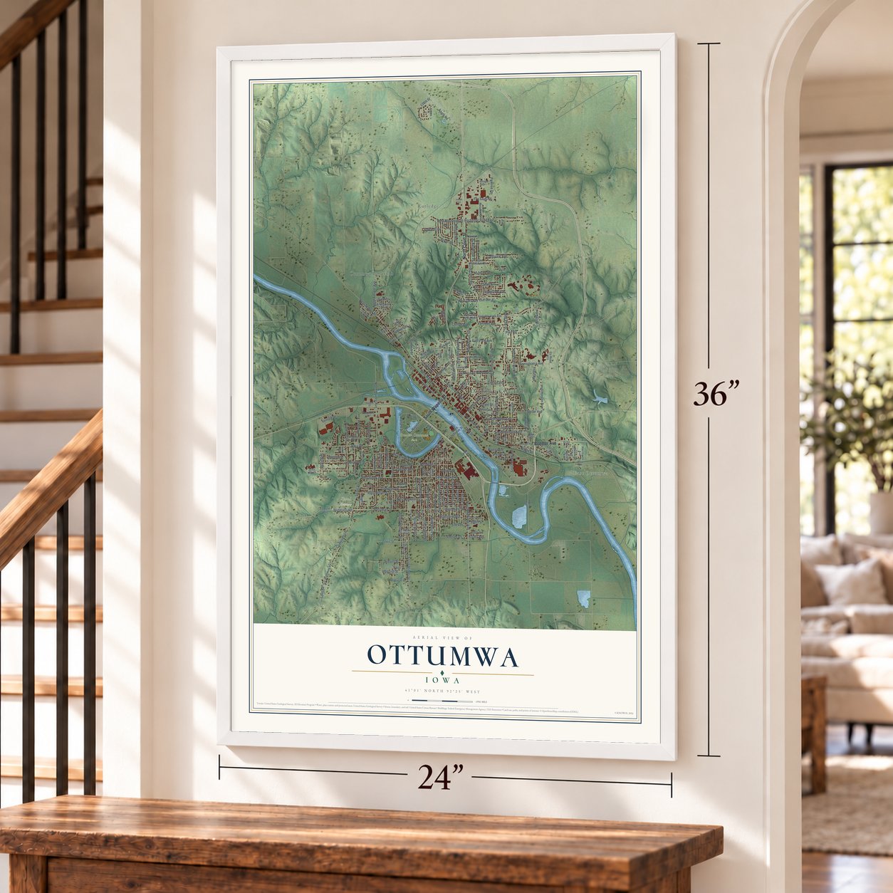
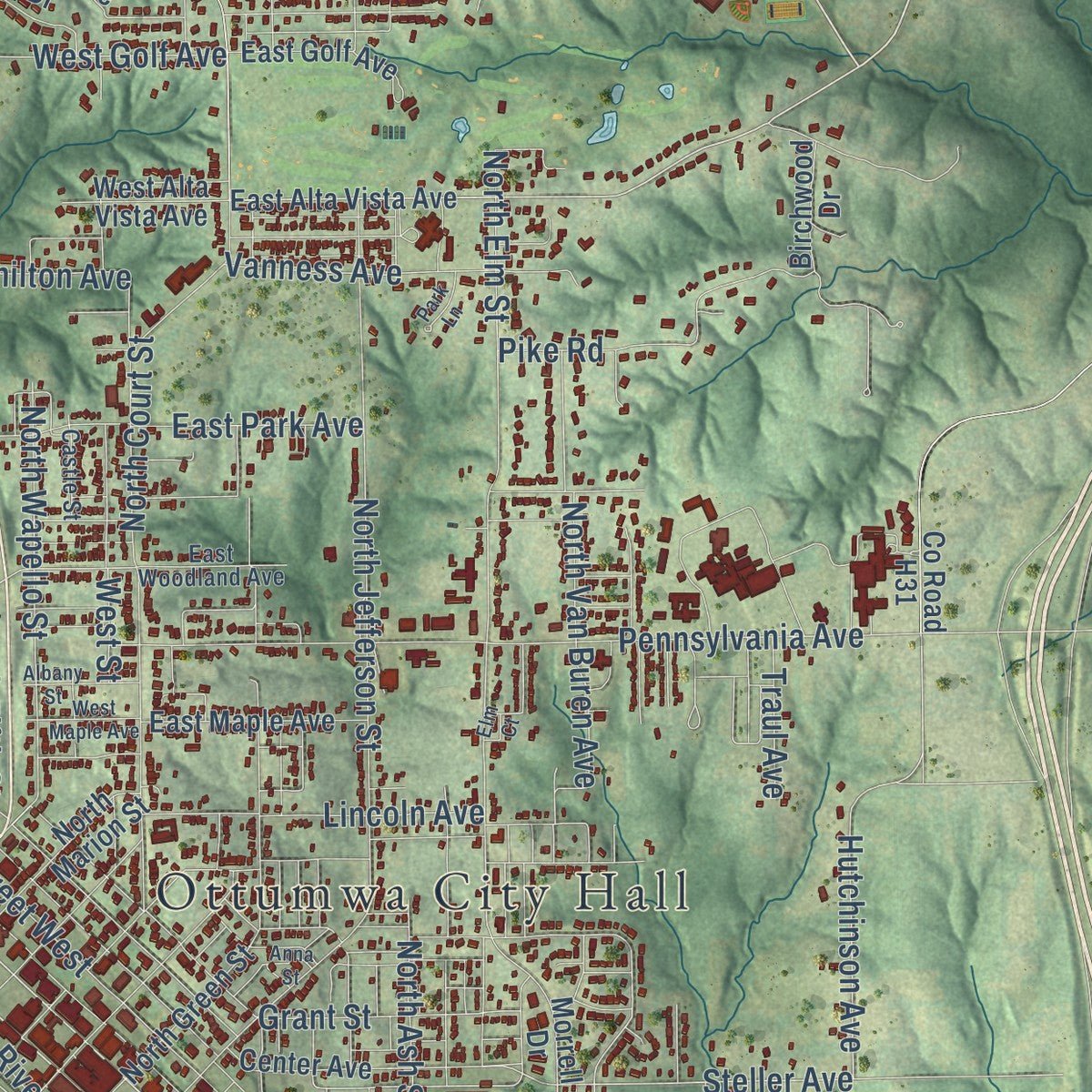
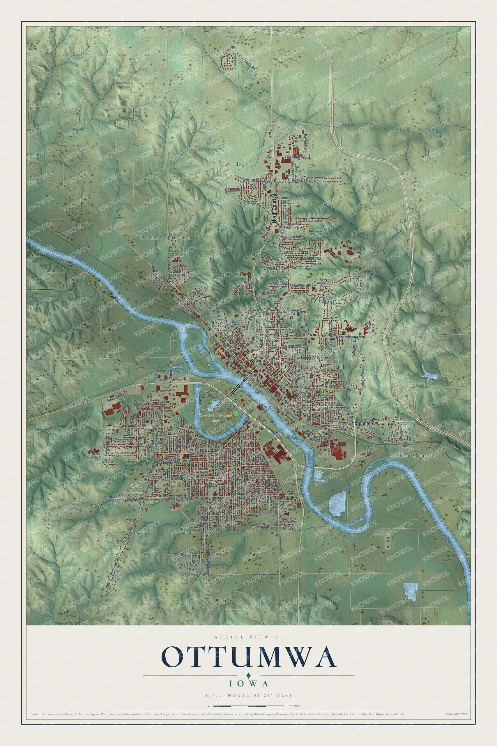
Explore Ottumwa, Iowa from a whole new perspective. Created using aerial imagery and detailed geographic data, this map captures Ottumwa building by building, with labeled streets, familiar landmarks, and shaded topographical relief that highlights the natural contours of the landscape.
Combining modern data with the timeless character of a vintage atlas, this map is just as interesting up close as it is beautiful on the wall. Whether you grew up in Ottumwa, spent memorable years there, or call it home today, this unique map is a great way to celebrate a place that means something to you. Zoom in on the preview to look for your street, and then order a print to put your memories on the wall.
Three ways to hang it
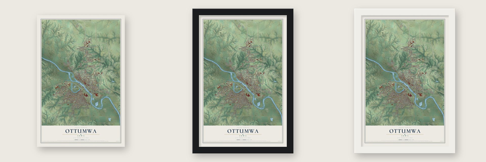
Unframed archival matte, a black wood frame or a white wood frame.
Up close
Geography Worth Displaying
This map was created using accurate cartographic data and authoritative geographic sources, including the U.S. Geological Survey and the Census Bureau. The map brings together terrain, waterways, roads, and building detail. The majority of the streets are labeled, houses are accurately depicted, and the topography is derived from government sources. Combining local data with carefully composed color and shading leads to this beautifully detailed Ottumwa artwork for your wall.
Rather than simply showing street outlines, we’ve included as many of the street names as we could reasonably fit on the map while keeping their names legible. Zoom in on the high resolution preview to see exactly what’s on the map. We truly set out to create a statement piece for anyone who loves Ottumwa. So whether it’s for you, or a gift for someone you love, we hope this map of Ottumwa brings back fond memories.

Find your street
Names on the Ottumwa map
Every name below is printed on this map. Look for your street, your school, the park where you played, or the pond down the road.
Places and landmarks7
- Ottumwa City Hall
- East Ottumwa
- Rutledge
- Pickwick
- Greater Ottumwa Park
- Shaul Cemetery
- Ottumwa Junction
Streets and roads207
- South Wapello Street
- Roemer Avenue
- North Court Street
- East Finley Avenue
- North Elm Street
- East Main Street
- West Main Street
- Church Street
- Rochester Road East
- Second Street East
- South Davis Street
- South Sheridan Avenue
- Adeline Road
- Caldwell Street
- West Rochester Street
- West Second Street
- North Van Buren Avenue
- North Court Road
- Steller Avenue
- Hutchinson Avenue
- South Willard Street
- Gurley Avenue
- South Milner Street
- East Vine Street
- West Mary Street
- South Iowa Avenue
- North Forrest Avenue
- South Madison Avenue
- North Jefferson Street
- West Finley Avenue
Show all 207 streets
- Chester Avenue
- County Highway V17
- County Road V17
- Lake Road
- South Webster Street
- Pennsylvania Avenue
- Albia Road
- Lillian Street
- North Quincy Avenue
- Greenwood Drive
- Wildwood Drive
- Richmond Avenue
- West Williams Street
- East Mary Street
- South Ward Street
- South Ransom Street
- Fourth Street East
- North Wapello Street
- South Adella Street
- Hayne Street
- Angle Road
- Locust Street
- North Ash Street
- Lincoln Avenue
- Grandview Avenue
- Fourth Street West
- South James Street
- Bryan Road
- Mallard Drive
- Hammond Avenue
- Bluegrass Road
- West Street
- Crestview Avenue
- Gateway Drive
- Mable Street
- Carter Avenue
- Plum Street
- Tuttle Street
- Bruce Street
- Grant Street
- Lark Lane
- Fox Sauk Road
- Overman Avenue
- West Keota Street
- Lewis Street
- Shaul Avenue
- Osceola Street
- Venture Drive
- Harvey Street
- Silk Avenue
- Vanness Avenue
- Skyline Drive
- Mill Street
- Railroad Street
- West Golf Avenue
- Summitt Street
- Pawnee Drive
- Traul Avenue
- Johnson Avenue
- East Park Avenue
- Kenwood Street
- Marilyn Road
- Edwards Drive
- North Fifth Street
- Pike Road
- Levee
- Chilton Avenue
- Ingersoll Street
- Dewey Street
- Sixth Street
- 138th Street
- River Drive
- South Street
- East Alta Vista Avenue
- Wapello Street
- West Alta Vista Avenue
- Highway Avenue
- South Jefferson Street
- North Ferry Street
- East Mc Pherson Avenue
- Herrmann Avenue
- Park Boulevard
- North McLean Street
- Frank Street
- South Ash Street
- 120th Avenue
- North Green Street
- South Moore Street
- Third Street West
- Glenwood Avenue
- South Hancock Street
- Fifth Street West
- Teal Drive
- County Road H41
- Oak Meadow Drive
- Gladstone Street
- Hand Avenue
- Center Avenue
- Woodshire Drive
- Birchwood Drive
- Asbury Avenue
- East Elmdale Avenue
- East Maple Avenue
- Hill Avenue
- Northview Avenue
- Ray Street
- East Golf Avenue
- North Pocahontas Street
- North Marion Street
- Montagne Lane
- North Walnut Avenue
- South Vine Street
- Burrhus Street
- Echo Street
- Burns Avenue
- Merrouge Avenue
- Waverly Avenue
- Hackworth Street
- Baldwin Avenue
- Lake Drive
- Earl Street
- Paris Street
- Sherwood Drive
- Leighton Street
- County Road H31
- Marina Drive
- Osage Drive
- Morrell Drive
- Bonita Avenue
- Gow Street
- Great Oak Drive
- Etta Street
- Vine Street
- East Division Street
- Arrison Street
- South Ferry Street
- South Weller Street
- South Elm Street
- Ellis Avenue
- North Davis Street
- Clarence Street
- East Woodland Avenue
- Elma Street
- North Ward Street
- Orchard Street
- North Holt Street
- Eleaner Drive
- Prosser Street
- Vaughn Drive
- Castle Street
- Brick Row
- Elm Street
- Gray Street
- Minneopa Avenue
- Hamilton Street
- McKinley Avenue
- Pinehurst Circle
- South Schuyler Street
- West Maple Avenue
- Albany Street
- Cass Street
- Joe Lord Memorial Drive
- Meadowdale Street
- Morris Street
- Hackberry Street
- Pin Oak Drive
- Samantha Street
- Kingsley Drive
- Monroe Avenue
- Garfield Street
- Weller Street
- Riverside Lane
- Anna Street
- Park Lane
- Joseph Avenue
- Cedar Croft
- Elm Court
Names are listed as they appear on the printed map. Zoom into the product photos to find them.
About Ottumwa, Iowa
Ottumwa is a city of 25,529 people and the seat of Wapello County, and the Des Moines River divides it into north and south halves. Its name comes from Fox, the language of the Meskwaki people, and means "tumbling waters," for the Appanoose Rapids on the river. The town grew where the Meskwaki chiefs Wapello and Appanoose had kept their camps.
The land opened to settlers in May 1843. That month a group of investors, the Appanoose Rapids Company, claimed 467 acres here, ground that held three Native villages. Army troops tore down one cabin built before the legal date, so the first lawful cabin also went up that May. The first plat was named Louis Ville, and in 1844 the town became the county seat. A Mr. Myers built its first flour mill in 1846, and the flood of 1851 badly damaged the town. The Burlington and Missouri River Railroad arrived in September 1859, and shops and factories spread along its tracks beside the river.
- The Coal PalaceBy 1857 miners dug coal from the McCready bank on Bear Creek, west of town. Brown and Godfrey's drift mine northwest of Ottumwa opened in 1868, and by 1872 its 300 men dug 77,000 tons a year. The state mine inspector found 15 shafts here in 1889. The city built the Coal Palace from 1890 to 1892 to show off its mines, and President Benjamin Harrison toured it in 1890, speaking to more than 40,000 people.
- Video Game Capital of the WorldThe Twin Galaxies arcade opened here on November 10, 1981, and its scoreboard tracked high scores sent in from around the world. In 1982 Mayor Jerry Parker named Ottumwa the "Video Game Capital of the World," Senator Charles Grassley recognized the title, and the arcade staged the first North American Video Olympics. The arcade closed on March 6, 1984, but the International Video Game Hall of Fame was founded in Ottumwa in 2009.
- Meatpacking and farm machinesJohn Morrell & Company and its meatpacking plant shaped the growth of Ottumwa from 1877 to 1973. Together with farm equipment made by John Deere, meatpacking was the work the city's economy grew on.
- Radar and the CanteenCpl. Walter "Radar" O'Reilly, the company clerk in the M*A*S*H book and TV series, came from Ottumwa. The Canteen Lunch in the Alley downtown has served its loose meat sandwich since the 1920s, and it was the model for the Lanford Lunch Box on the sitcom Roseanne.
Keep exploring Iowa
Ottumwa is one of 1,038 Iowa towns we've mapped. Every dot on the map is a print of its own.
The search covers every state, Iowa first.
Near Ottumwa
Order 2 or more town maps and save 10%. Shown in the size and finish you picked above, so they hang as a set.
- Agency 12" x 18" / Archival Matte Print $39.99
- Chillicothe 12" x 18" / Archival Matte Print $39.99
- Kirkville 12" x 18" / Archival Matte Print $39.99


More maps nearby: Blakesburg, Floris, Hedrick, Eldon and Fremont.
The art of mapping a place
How This Map Was Made
Real places. Remarkable detail. Discover the layers that turn geographic data into a map of home.

The view from above
Aerial imagery reveals the character of the land: woodland, open fields, and the patterns of a place.

The shape of the land
Elevation data brings hills, valleys, and subtle changes in the landscape into view.

The details of home
Roads, waterways, and building footprints come together to make the map feel unmistakably local.

Geography becomes art
Considered color, shading, and typography bring the layers together in a map made for your wall.


Process illustrated with Mendon, Massachusetts. Aerial imagery: USDA NAIP. Terrain: USGS 3D Elevation Program. Map details and finished artwork: KNOWOL.
The Details
About This Print
Choose an archival matte print, or a black or white Ayous wood frame. The archival matte print is unframed.
Select your size and finish above to see the matching product image and price.
Materials & Craftsmanship
A contemporary map with the character of a classic atlas, printed on archival matte paper. Optional frames are made from Ayous wood.
Your printed map does not include the watermark shown in the full-map preview.
Shipping & Delivery
Free shipping within the United States. Every print is made to order in the USA.
Buying a gift? Add a note in your cart and we'll include it. We never put prices in the package.
Prints ship within 2 to 3 business days. Allow 7 to 10 days total from ordering for delivery. Timing may vary during holidays or periods of high order volume.
Read our shipping policy.
Returns and damaged prints
Each print is made to order. Change-of-mind refunds are not available after production.
If your print arrives damaged, misprinted or incorrect, contact support@knowol.com within 30 days of receiving it. Include your order number, photos and a description of the issue.
Read our full refund and replacement policy. For questions about your order, email support@knowol.com.