
Search for another town


Free U.S. delivery 7 to 10 days after you order
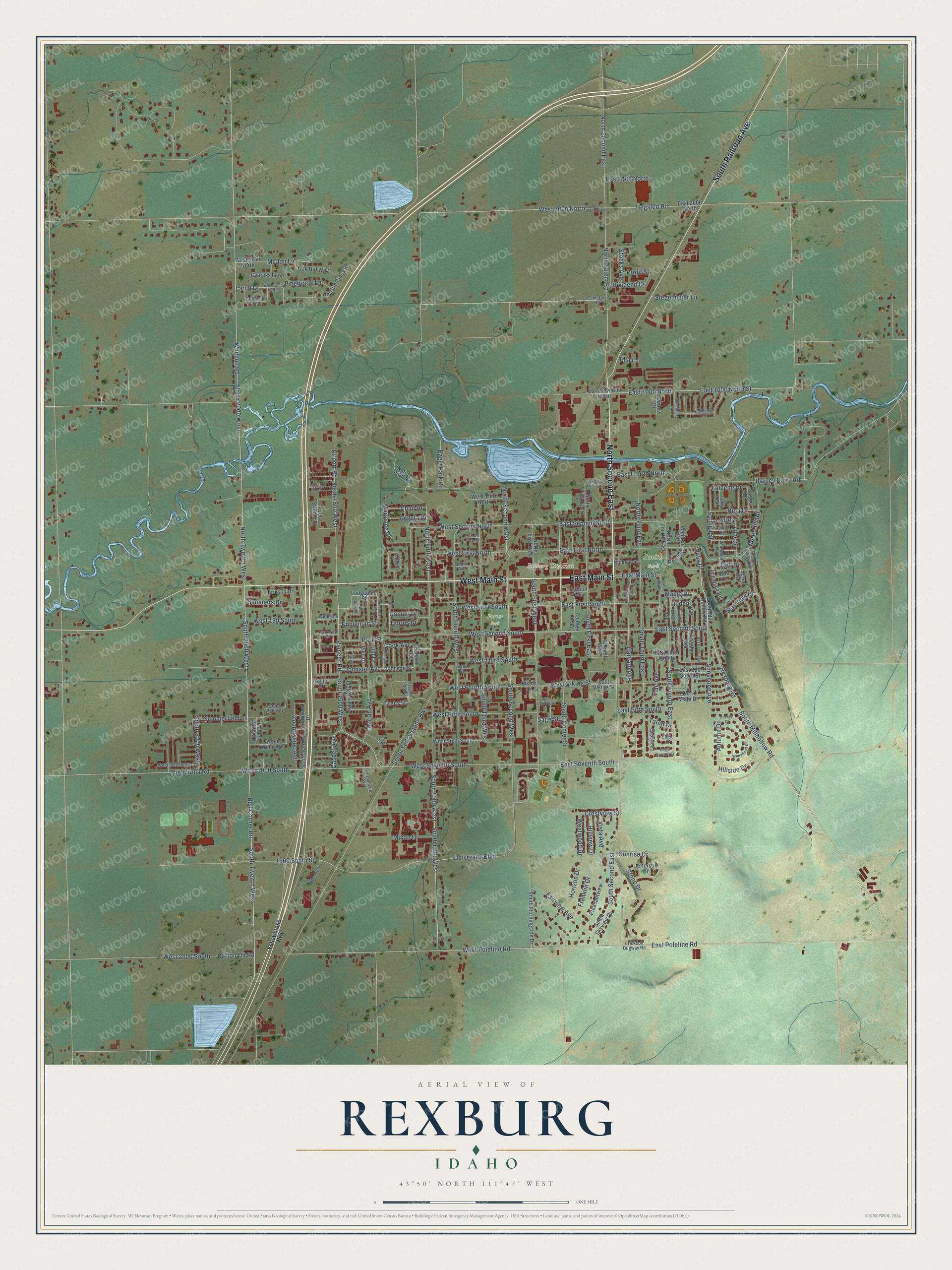
Rexburg, Idaho Map Art
Building by building, with labeled streets and shaded relief.
12" x 18" Archival Matte Print
A Map of Home. A Work of Art.
Explore Rexburg, Idaho from a whole new perspective. Created using aerial imagery and detailed geographic data, this map captures Rexburg building by building, with labeled streets, familiar landmarks, and shaded topographical relief that highlights the natural contours of the landscape.
Combining modern data with the timeless character of a vintage atlas, this map is just as interesting up close as it is beautiful on the wall. Whether you grew up in Rexburg, spent memorable years there, or call it home today, this unique map is a great way to celebrate a place that means something to you. Zoom in on the preview to look for your street, and then order a print to put your memories on the wall.
Three ways to hang it

Unframed archival matte, a black wood frame or a white wood frame.
Up close
Geography Worth Displaying
This map was created using accurate cartographic data and authoritative geographic sources, including the U.S. Geological Survey and the Census Bureau. The map brings together terrain, waterways, roads, and building detail. The majority of the streets are labeled, houses are accurately depicted, and the topography is derived from government sources. Combining local data with carefully composed color and shading leads to this beautifully detailed Rexburg artwork for your wall.
Rather than simply showing street outlines, we’ve included as many of the street names as we could reasonably fit on the map while keeping their names legible. Zoom in on the high resolution preview to see exactly what’s on the map. We truly set out to create a statement piece for anyone who loves Rexburg. So whether it’s for you, or a gift for someone you love, we hope this map of Rexburg brings back fond memories.

Find your street
Names on the Rexburg map
Every name below is printed on this map. Look for your street, your school, the park where you played, or the pond down the road.
Places and landmarks3
- Rexburg City Hall
- Smith Park
- Porter Park
Streets and roads206
- West Main Street
- North Second East
- East Main Street
- South Railroad Avenue
- South Millhollow Road
- East Second South
- South Center Street
- Willis Drive
- Bell Corner Road
- South 2000 West
- North 2000 West
- West Seventh South
- Whitson Road
- East Poleline Road
- Rexburg Road
- East Second North
- Shoshone Avenue
- Pioneer Road
- University Boulevard
- South Second West
- South Second East
- South Twelfth West
- East 1000 North
- East 1000 North Street
- West Second North
- North Fifth West
- Syringa Street
- Laleene Drive
- South Fifth West
- South First West
Show all 206 streets
- West 1000 South
- South 1500 West
- South Third East
- West Fourth South
- East First South
- Westwood Drive
- South First East
- Johnson Avenue
- South Fourth West
- Nina Drive
- Laurel
- East First North
- 1600 South Street
- East Seventh South
- North Salem Road
- South Yellowstone Highway
- North Twelfth West
- West 2000 South
- Barney Dairy Road
- South Third West
- Hegsted Road
- North 1500 West
- South 1000 West
- The Burma Road
- West First North
- Airport Road
- West Second South
- South Fourth East
- North Hill Road
- Burton Oil Road
- Harvard Avenue
- West First South
- West Fifth South
- North Third East
- West Poleline Road
- Park Street
- North Second West
- Stone Drive
- Larch Drive
- Fairview Avenue
- East Fifth South
- West Third South
- West 190 South
- Mariah Avenue
- Maple Drive
- Oaktrail Drive
- McJon Lane
- Sunrise Drive
- Countryside Avenue
- West 2000 North
- Yale Avenue
- East Fourth North
- Trejo Street
- Hillside Drive
- Autumn Drive
- South 2275 West
- Summerfield Lane
- Pinebrook Lane
- West Viking Street
- Dividend Drive
- Horizon Drive
- Franklin Drive
- East 15th North
- Summers Drive
- Stegelmeier Lane
- Linden Avenue
- Casper Avenue
- Taurus Drive
- Star View Drive
- Hillview Drive
- Eagle Park Road
- Mikan Drive
- Marianne Drive
- Vista Avenue
- Angela Drive
- Chad Drive
- Crestview Street
- Enbleman Street
- Stocks Avenue
- Lilac Street
- Dell Drive
- Gemini Drive
- Cook Avenue
- Profit Street
- Jill Drive
- Sage Street
- Reed Street
- Talon Drive
- Ella Lane
- South Mill Hollow Road
- Lodgepole Street
- Sunflower Road
- Sunflower Drive
- Pollard Avenue
- East Seventh North
- East 2000 North
- North First East
- East Third South
- West Sixth South
- West 1750 North
- Jet Stream Drive
- Terra Vista Drive
- Nature Park Road
- South Morningside Drive
- Cypress Loop
- North First West
- College Avenue
- East 350 South Street
- North Fourth East
- Oak Hill Way
- South Skyview Drive
- Anne Street
- Mill Race Road
- West Third North
- Castle Pines Road
- Arctic Willow Drive
- Pleasantview
- Birch Avenue
- Johnson Street
- Apache Avenue
- Jefferson Drive
- Polo Drive
- Golden Willow Drive
- Ricks Avenue
- Carlson Avenue
- East Viking Street
- Erikson Drive
- Madison Avenue
- Cornell Avenue
- Viking Drive
- Carlow Drive
- Gary Drive
- Susan Drive
- Vale Lane
- Jerry Avenue
- Yellowstone Highway
- Erickson Dugway Road
- Widdison Lane
- Grand Loop Drive
- Greenside Loop
- West 960 South
- Eaglewood Drive
- Marigold Street
- Green Willow Drive
- Ash Avenue
- Cornelison Avenue
- Laurel Street
- Cemetery Road
- Parkside Drive
- Yost Street
- Cul de Sac Street
- Salem Avenue
- Bare Street
- Eagle Court
- Ponderosa Avenue
- Harvest Drive
- West Moody Road
- West 1600 North
- West 515 North
- Turin Way
- Douglas Drive
- Golden Beauty Drive
- Wheatland Drive
- Aries Drive
- Nez Perce Avenue
- East Third North Street
- Stonebridge Street
- East Sunset Circle
- Seagull Drive
- West Campus Street
- Professional Plaza
- Elm Avenue
- Eagle Summit Street
- Woodbridge Street
- Hidden Valley Road
- Capital Lane
Names are listed as they appear on the printed map. Zoom into the product photos to find them.
About Rexburg, Idaho
Rexburg is a city of 39,409 people and the county seat of Madison County. Thomas E. Ricks founded it, and the town's name comes from his. When pioneers came to settle this part of eastern Idaho in 1883, Rexburg was the first town they laid out, though seven families were already living at what became Parker and a few more at Menan and Idaho Falls.
The settlers set up a school right away. Its first term opened near the end of December 1883, with Thomas E. Bassett and Sarah Ann Barnes teaching children of every age together in one ungraded room. Rexburg was incorporated the same year. In 1888 a small academy opened here, and it grew into Ricks College, named for the founder. On August 10, 2001, the college became a four-year university and took the name BYU-Idaho.
“The Square was the gathering place for Rexburg and surrounding areas for patriotic, political, community and family activities. By 1912, the Rexburg LDS Tabernacle was completed and many of the activities moved there, away from the Public Square.”
- The Teton Dam Flood of 1976In June 1976 the Teton Dam ruptured. The Teton River, which runs through the north side of town, then left most of Rexburg underwater for several days. A museum in the basement of the Rexburg Tabernacle now tells the story of the flood and of the town, and it has been one of the city's best known landmarks for decades.
- A Navy ship named RexburgThe USS Rexburg, an oceanographic research ship that served the Navy Electronics Laboratory, carried the city's name.
- A town on a shield volcanoMuch of Rexburg, including the BYU-Idaho campus and the Rexburg Idaho Temple, sits on an old shield volcano. Lava fields lie to the west and south, left by fissure eruptions roughly two thousand years ago, and the soil that volcanism enriched helps area farms grow large, starchy potatoes.
Keep exploring Idaho
Rexburg is one of 279 Idaho towns we've mapped. Every dot on the map is a print of its own.
The search covers every state, Idaho first.
Near Rexburg
Order 2 or more town maps and save 10%. Shown in the size and finish you picked above, so they hang as a set.
- Hibbard 12" x 18" / Archival Matte Print $39.99
- Salem 12" x 18" / Archival Matte Print $39.99
- Sugar City 12" x 18" / Archival Matte Print $39.99


The art of mapping a place
How This Map Was Made
Real places. Remarkable detail. Discover the layers that turn geographic data into a map of home.

The view from above
Aerial imagery reveals the character of the land: woodland, open fields, and the patterns of a place.

The shape of the land
Elevation data brings hills, valleys, and subtle changes in the landscape into view.

The details of home
Roads, waterways, and building footprints come together to make the map feel unmistakably local.

Geography becomes art
Considered color, shading, and typography bring the layers together in a map made for your wall.


Process illustrated with Mendon, Massachusetts. Aerial imagery: USDA NAIP. Terrain: USGS 3D Elevation Program. Map details and finished artwork: KNOWOL.
The Details
About This Print
Choose an archival matte print, or a black or white Ayous wood frame. The archival matte print is unframed.
Select your size and finish above to see the matching product image and price.
Materials & Craftsmanship
A contemporary map with the character of a classic atlas, printed on archival matte paper. Optional frames are made from Ayous wood.
Your printed map does not include the watermark shown in the full-map preview.
Shipping & Delivery
Free shipping within the United States. Every print is made to order in the USA.
Buying a gift? Add a note in your cart and we'll include it. We never put prices in the package.
Prints ship within 2 to 3 business days. Allow 7 to 10 days total from ordering for delivery. Timing may vary during holidays or periods of high order volume.
Read our shipping policy.
Returns and damaged prints
Each print is made to order. Change-of-mind refunds are not available after production.
If your print arrives damaged, misprinted or incorrect, contact support@knowol.com within 30 days of receiving it. Include your order number, photos and a description of the issue.
Read our full refund and replacement policy. For questions about your order, email support@knowol.com.