


Search for another town



Free U.S. delivery 7 to 10 days after you order
Riverbank, California Map Art
Building by building, with labeled streets and shaded relief.
12" x 18" Archival Matte Print
A Map of Home. A Work of Art.
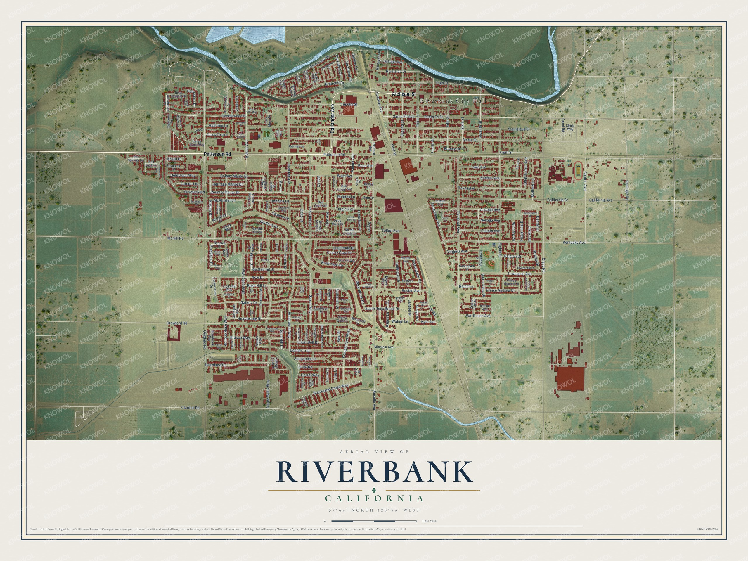
Explore Riverbank, California from a whole new perspective. Created using aerial imagery and detailed geographic data, this map captures Riverbank building by building, with labeled streets, familiar landmarks, and shaded topographical relief that highlights the natural contours of the landscape.
Combining modern data with the timeless character of a vintage atlas, this map is just as interesting up close as it is beautiful on the wall. Whether you grew up in Riverbank, spent memorable years there, or call it home today, this unique map is a great way to celebrate a place that means something to you. Zoom in on the preview to look for your street, and then order a print to put your memories on the wall.
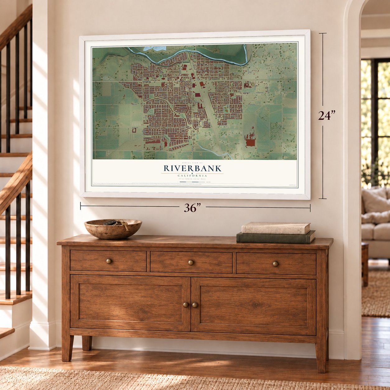
Three ways to hang it
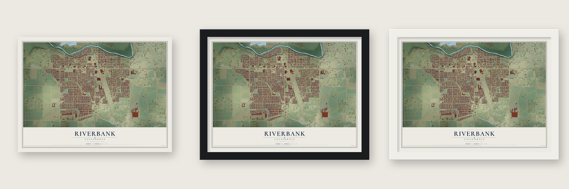
Unframed archival matte, a black wood frame or a white wood frame.
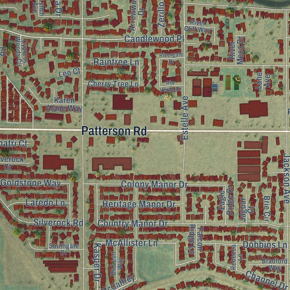
Up close
Geography Worth Displaying
This map was created using accurate cartographic data and authoritative geographic sources, including the U.S. Geological Survey and the Census Bureau. The map brings together terrain, waterways, roads, and building detail. The majority of the streets are labeled, houses are accurately depicted, and the topography is derived from government sources. Combining local data with carefully composed color and shading leads to this beautifully detailed Riverbank artwork for your wall.
Rather than simply showing street outlines, we’ve included as many of the street names as we could reasonably fit on the map while keeping their names legible. Zoom in on the high resolution preview to see exactly what’s on the map. We truly set out to create a statement piece for anyone who loves Riverbank. So whether it’s for you, or a gift for someone you love, we hope this map of Riverbank brings back fond memories.
Read the story behind this map of Riverbank, California from 2026.

Find your street
Names on the Riverbank map
Every name below is printed on this map. Look for your street, your school, the park where you played, or the pond down the road.
Places and landmarks2
- Riverbank City Hall
- Silva Park
Streets and roads248
- Patterson Road
- Callander Avenue
- Atchison Street
- Tennessee Avenue
- Hearthsong Drive
- Rio Gabriel Street
- Webb Street
- Estelle Avenue
- Candlewood Place
- Landon Drive
- McAllister Lane
- Engstrom Drive
- Virginia Avenue
- Kasper Drive
- Seventh Street
- Newbrook Circle
- Coad Lane
- Rose Brook Drive
- Lindbrook Drive
- Robirds Lane
- Spur Street
- Claribel Road
- Oakdale Road
- Claus Road
- Santa Fe Street
- Sierra Street
- Stanislaus Street
- Crawford Road
- Roselle Avenue
- Morrill Road
Show all 248 streets
- Santa Fe Avenue
- Topeka Street
- Eighth Street
- Squire Wells Way
- California Avenue
- California Street
- Terminal Avenue
- Homewood Way
- Kentucky Avenue
- Jackson Avenue
- Saxon Way
- River Cove Drive
- Central Avenue
- First Street
- Antique Rose Way
- Gallery Drive
- Novi Drive
- Country Manor Drive
- Briarcliff Drive
- Riverside Drive
- Prospectors Parkway
- Second Street
- Donner Trail
- Howard Avenue
- Townsend Avenue
- Turpin Avenue
- Chancellor Way
- Ward Avenue
- Ross Avenue
- Third Street
- Snedigar Road
- Glow Road
- Kansas Avenue
- High Street
- Blacksand Creek Way
- Fourth Street
- Silverock Road
- South Rose Brook Drive
- Texas Avenue
- Arizona Avenue
- Fifth Street
- Heartland Drive
- Front Street
- Rose Hill Lane
- Colony Manor Drive
- Prince Andrew Drive
- Don Avenue
- Pocket Avenue
- Bordona Drive
- Dobbins Lane
- Bracco Way
- Iowa Avenue
- Dakota Avenue
- Nevada Avenue
- Sixth Street
- Prestwick Drive
- Condray Avenue
- Channel Drive
- Zerillo Drive
- Litt Road
- Belgian Drive
- Palmer Avenue
- Heritage Manor Drive
- Talbot Avenue
- Portico Drive
- Silver Bell Drive
- Goldstone Way
- Eisenhower Drive
- Chief Tucker Avenue
- Van Dusen Avenue
- Turnberry Lane
- Holbrook Drive
- Allegiance Lane
- Cherry Oaks Place
- Dunbar Lane
- Arcaro Drive
- Preakness Drive
- Stretch Drive
- Laredo Lane
- Sierra Vista Drive
- Orange Avenue
- Raintree Lane
- Cervi Road
- Panorama Drive
- Walnut Lane
- Corral Way
- Tina Lane
- Suttermill Drive
- Canter Drive
- Winners Circle
- Mathew Lane
- Burney Court
- Aspen Lane
- Kyle Avenue
- Gold Hill Drive
- Reich Lane
- Khatri Court
- Sire Court
- Don Court
- Hawaii Avenue
- Huntley Street
- Woodhaven Place
- McCaffrey Lane
- Castleberg Drive
- Savage Avenue
- Martel Avenue
- Ryanlee Drive
- Boardwalk Way
- Cooper Way
- Sutton Road
- Lenay Way
- Cornerstone Drive
- Silversmythe Lane
- Cherry Tree Lane
- Hot Springs Lane
- Creek Bend Drive
- Burneyville Road
- Minniear Avenue
- Lemons Street
- Castlepark Drive
- Royal Links Drive
- River Heights Drive
- Arrowwood Drive
- Garden Oak Drive
- Doubloon Street
- Cottage Cove Drive
- Crystal Falls Drive
- Incline Way
- Karen Alane Way
- San Juan Avenue
- Marsh Creek Lane
- Don Rafael Avenue
- Cipponeri Road
- Parsley Lane
- Railroad Avenue
- Courtyard Way
- Prince George Lane
- Eagle Ridge Drive
- Deep River Drive
- Equine Court
- Silverock Court
- Fern Court
- Mineshaft Court
- Jandee Way
- Falcon Ridge Lane
- Crossing Way
- Miwok Way
- Soares Place
- Stride Way
- Coloma Court
- Arnerich Court
- Red Rock Lane
- Rocky Lane
- Jaguar Court
- River Mesa Drive
- Brie Circle
- Burning Tree Court
- Willow Song Court
- Sierra Gold Court
- Kings Mill Court
- Webb Court
- Lane Avenue
- Leo Court
- Hull Court
- Sulky Court
- Clydesdale Lane
- Buck Hill Way
- Bradford Way
- De Leon Way
- Gleneagles Drive
- Lynch Avenue
- Story Brook Lane
- Medallion Court
- Silvervale Court
- Buckskin Way
- Southgate Drive
- Yearling Court
- Cypress Woods Circle
- River Cliff Way
- Saint Lakes Court
- Stable Way
- Spanish Bay Court
- Blazer Court
- Austin Avenue
- Rebecca Lane
- Huntley Court
- Chavez Road
- Lily Court
- Bessac Drive
- Prince Norman Way
- Sweepstakes Drive
- Promenade Way
- Etherington Court
- Barger Way
- Ashlar Way
- Clearwater Way
- Don Carlos Avenue
- Blessing Court
- Creek Bend Court
- Lipizzan Court
- Spaulding Court
- Darpinian Court
- Feather Court
- Alarose Way
- Bungalow Court
- Bullion Court
- Madera Court
- Rivergate Drive
- Horsetail Falls Court
- Rio Verde Drive
- McArthur Court
- Gable Court
- Aspen Court
- Browns Court
- Rose Hill Court
- Perrin Court
- Sierra Court
- Lloyd Court
Names are listed as they appear on the printed map. Zoom into the product photos to find them.
About Riverbank, California
Riverbank is a city of 24,865 people in Stanislaus County, and it takes its name from its place on the Stanislaus River. In the 1850s the spot was known as Burneyville, after Major James Burney, the sheriff of Mariposa, who ran a ferry across the river where the Riverbank bridge stands today. The San Francisco & San Joaquin Valley Railroad laid its tracks here about 1895 and opened a station called Riverbank, and in 1900 the Atchison, Topeka & Santa Fe took over the line.
In 1910 the Santa Fe made Riverbank a division terminal, splitting its long run between Richmond and Fresno, and it put up concrete machine shops, roundhouses, oil tanks and towers. Within a year, 400 or 500 railroad workers and their families lived here. The Riverbank Land Company, organized about 1910, laid out the townsite on several hundred acres, and stores, a bank, churches and lodges soon followed. Riverbank was incorporated as a city on August 23, 1922.
- A Santa Fe railroad townBy the time the county history was written, Riverbank had twelve hundred people, and as a Santa Fe division point it paid out $30,000 to $50,000 a month in wages. Many shopmen and trainmen owned their own homes on one to twenty acres. Every day, twenty-six passenger trains and eighteen freight trains left the station.
- A church from Burneyville daysRiverbank's Methodist Episcopal church began as the Burneyville Methodist Episcopal Church, which the Reverend Belknap Sr. organized in 1865. The congregation built its Riverbank church in February 1912 for $2,000, and James H. Rodgers served as its pastor there from 1912 to 1916.
- Riverbank's first Fourth of JulyThe Woman's Improvement Club organized the town's first Independence Day celebration. About fifty schoolchildren, each holding a flag, marched with townspeople from the Methodist Church to the water tower behind a fife and drum. There a large flag went up the staff while Mrs. Louise Riechman sang the "Star Spangled Banner," Robert Callandar read the Declaration of Independence and F. A. Raney gave the oration.
- A ferryman in the plazaRiverbank remodeled its downtown in 2009 and added a plaza with a mural and a statue honoring a cable ferry operator, recalling the Burneyville Ferry where the town began. Each October the Riverbank Cheese and Wine Festival offers tastings of wine and cheese along with crafts and vendors.
Keep exploring California
Riverbank is one of 1,990 California towns we've mapped. Every dot on the map is a print of its own.
The search covers every state, California first.
Near Riverbank
Order 2 or more town maps and save 10%. Shown in the size and finish you picked above, so they hang as a set.
- Del Rio 12" x 18" / Archival Matte Print $39.99
- Van Allen 12" x 18" / Archival Matte Print $39.99
- Escalon 12" x 18" / Archival Matte Print $39.99

More maps nearby: Oakdale, Empire, Airport, Modesto and Valley Home.
The art of mapping a place
How This Map Was Made
Real places. Remarkable detail. Discover the layers that turn geographic data into a map of home.

The view from above
Aerial imagery reveals the character of the land: woodland, open fields, and the patterns of a place.

The shape of the land
Elevation data brings hills, valleys, and subtle changes in the landscape into view.

The details of home
Roads, waterways, and building footprints come together to make the map feel unmistakably local.

Geography becomes art
Considered color, shading, and typography bring the layers together in a map made for your wall.


Process illustrated with Mendon, Massachusetts. Aerial imagery: USDA NAIP. Terrain: USGS 3D Elevation Program. Map details and finished artwork: KNOWOL.
The Details
About This Print
Choose an archival matte print, or a black or white Ayous wood frame. The archival matte print is unframed.
Select your size and finish above to see the matching product image and price.
Materials & Craftsmanship
A contemporary map with the character of a classic atlas, printed on archival matte paper. Optional frames are made from Ayous wood.
Your printed map does not include the watermark shown in the full-map preview.
Shipping & Delivery
Free shipping within the United States. Every print is made to order in the USA.
Buying a gift? Add a note in your cart and we'll include it. We never put prices in the package.
Prints ship within 2 to 3 business days. Allow 7 to 10 days total from ordering for delivery. Timing may vary during holidays or periods of high order volume.
Read our shipping policy.
Returns and damaged prints
Each print is made to order. Change-of-mind refunds are not available after production.
If your print arrives damaged, misprinted or incorrect, contact support@knowol.com within 30 days of receiving it. Include your order number, photos and a description of the issue.
Read our full refund and replacement policy. For questions about your order, email support@knowol.com.