


Search for another town


Free U.S. delivery 7 to 10 days after you order
Rosedale, Maryland Map Art
Building by building, with labeled streets and shaded relief.
12" x 18" Archival Matte Print
A Map of Home. A Work of Art.
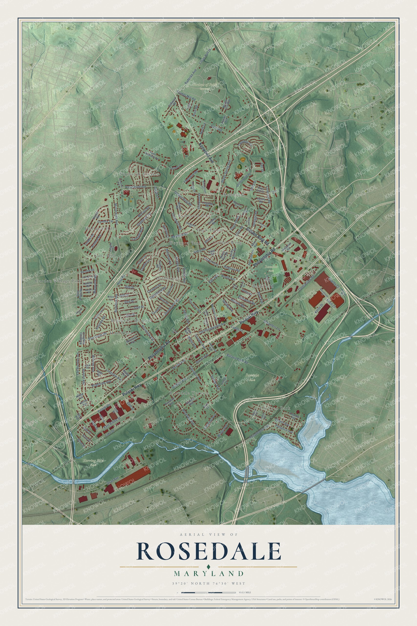
Explore Rosedale, Maryland from a whole new perspective. Created using aerial imagery and detailed geographic data, this map captures Rosedale building by building, with labeled streets, familiar landmarks, and shaded topographical relief that highlights the natural contours of the landscape.
Combining modern data with the timeless character of a vintage atlas, this map is just as interesting up close as it is beautiful on the wall. Whether you grew up in Rosedale, spent memorable years there, or call it home today, this unique map is a great way to celebrate a place that means something to you. Zoom in on the preview to look for your street, and then order a print to put your memories on the wall.
Three ways to hang it

Unframed archival matte, a black wood frame or a white wood frame.
Up close
Geography Worth Displaying
This map was created using accurate cartographic data and authoritative geographic sources, including the U.S. Geological Survey and the Census Bureau. The map brings together terrain, waterways, roads, and building detail. The majority of the streets are labeled, houses are accurately depicted, and the topography is derived from government sources. Combining local data with carefully composed color and shading leads to this beautifully detailed Rosedale artwork for your wall.
Rather than simply showing street outlines, we’ve included as many of the street names as we could reasonably fit on the map while keeping their names legible. Zoom in on the high resolution preview to see exactly what’s on the map. We truly set out to create a statement piece for anyone who loves Rosedale. So whether it’s for you, or a gift for someone you love, we hope this map of Rosedale brings back fond memories.
Read the story behind this map of Rosedale, Maryland from 2026.

Find your street
Names on the Rosedale map
Every name below is printed on this map. Look for your street, your school, the park where you played, or the pond down the road.
Places and landmarks19
- Batavia Park
- Gardens of Faith Cemetery
- Herring Run Park
- Rosedale Park
- Holland Hills
- Bluegrass Heights
- Daybreak Estates
- Rosedale Terrace
- Kenwood
- Hillbrook
- High Point
- Weyburn Park
Show all 19 places
- Garden Village Park
- Berkfield
- Kenwood Park
- Lutz Hill
- Golden Ring
- Chesaco Park
- Hamilton
Streets and roads167
- Golden Ring Road
- Kenwood Avenue
- Philadelphia Road
- Pulaski Highway
- Rosedale Avenue
- Hamilton Avenue
- Hazelwood Avenue
- East Biddle Street
- 35th Street
- Woodhaven Road
- 62nd Street
- Chesaco Avenue
- Radecke Avenue
- Daybreak Terrace
- Weyburn Road
- Trumps Mill Road
- Old Philadelphia Road
- Todds Lane
- McCormick Avenue
- East Avenue
- Quad Avenue
- Analee Avenue
- Rosewick Avenue
- Lillian Holt Drive
- Delegge Road
- Contractors Road
- Schaefers Lane
- Summit Avenue
- Sagramore Road
- Wilhelm Avenue
Show all 167 streets
- Batavia Farm Road
- Lake Drive
- Spring Avenue
- Patapsco Avenue
- Coco Road
- Brightside Avenue
- Cynthia Terrace
- Marquette Road
- Tarpleys Circle
- Seling Avenue
- Horst Road
- Fordcrest Road
- Shady Spring Avenue
- Avery Road
- Longview Avenue
- Blue Grass Road
- Rustic Avenue
- Pulaski Drive
- Kelso Drive
- Arnhem Road
- Getty Drive
- McFaul Road
- Sumter Avenue
- 32nd Street
- Leiden Road
- Flintshire Road
- Hilldale Road
- Severn Avenue
- Philadelphia Avenue
- Gilmore Avenue
- Duvall Avenue
- Shirley Avenue
- 33rd Street
- Commons Road
- Elmhurst Avenue
- 31st Street
- Krueger Avenue
- 63rd Street
- Callo Lane
- 34th Street
- Lanham Way
- Berk Avenue
- Bridge Avenue
- Dorset Avenue
- 64th Street
- Caradoc Drive
- National Road
- Berkwood Road
- Holyoke Road
- 68th Street
- North Lane
- Daytona Road
- 65th Street
- Roxboro Road
- Zangs Lane
- Candle Lane
- White Avenue
- Rush Road
- Talc Drive
- Osprey Court
- Finch Court
- Karl Avenue
- Oakdale Avenue
- Neighbors Avenue
- Goldenwood Road
- Point Pleasant Road
- Chapel Hill Drive
- Ellinwood Road
- Utrecht Road
- Potomac Avenue
- Saint Regis Road
- Edwill Avenue
- Corkley Road
- Allison Lane
- Willann Road
- Twilight Court
- East Boundary Avenue
- Rocky Mount Road
- Brian Road
- Customs Road
- Mount Airy Road
- Pine Grove Avenue
- Riverdale Avenue
- 67th Street
- Garvey Road
- 66th Street
- Lacotti Lane
- Lanette Road
- Bluegrass Heights Court
- Morgan Ellis Way
- Barstow Road
- Langdale Road
- Cavel Road
- Camhill Drive
- Weyfield Court
- Lawrence Avenue
- Cliffwood Road
- Roseland Avenue
- Gettig Road
- McDaniel Road
- Heinle Avenue
- Kern Avenue
- Days End Court
- Aster Road
- Sellier Avenue
- Hensel Avenue
- Berk Lane
- Price Lane
- Beatty Avenue
- Hilltop Avenue
- Odell Avenue
- Hamiltowne Circle
- Langdon Lane
- Wintergreen Place
- Linden Avenue
- Kelbourne Road
- Walnut Avenue
- Nahant Road
- Farmview Avenue
- Marshfield Court
- Trumps Court
- Fieldvale Road
- Tameron Place
- Pelican Court
- South Road
- Kahler Avenue
- Schering Road
- Towns Court
- Wilenoak Court
- Framingham Road
- Kendrick Road
- Narcissus Avenue
- Havenoak Road
- Martinque Road
- Roferd Avenue
- Thomas Avenue
- Dalton Avenue
Names are listed as they appear on the printed map. Zoom into the product photos to find them.
About Rosedale, Maryland
Rosedale is a community of 19,961 people in Baltimore County, northeast of the city of Baltimore. From the days of the first settlers and the people they enslaved, it was plantation land and then farmland, and it stayed that way until suburban building began after World War II. Its main road, now Maryland Route 7, was first the Philadelphia Road, and George Washington rode it to New York in 1789 to be inaugurated as the first president.
In the late 1800s, immigrants from Germany, Poland and England settled here. Many raised fruits and vegetables and carried them to markets in Baltimore, while others worked in nearby iron mines or kept a tavern. The Rosedale Community Improvement Association pushed for a post office of its own, and in 1927 one was established under the name Rosedale.
- A name from a rose farmNo record settles where the name came from. In 1950 a fourth-grade class interviewed longtime residents about their community's past and heard about a young Englishman named Dale, whose farm on Hamilton Avenue, just above Philadelphia Road, was covered in roses. People in town put his name and his flowers together.
- Schooners up Back RiverCharles Schatzschneider came from Germany at 13 to work on farms and settled in Rosedale. By 1940, when an article marked his 59th wedding anniversary, he had watched the rural community gain gas and electric lights, water and sewer lines, paved streets and fast electric trains. When he first arrived, three-masted schooners could still sail up Back River to the heading.
- A two-room first schoolRosedale's first school was a two-room wooden building where Hamilton Avenue meets Philadelphia Road. By 1950 the old schoolhouse had a new job as a fire house and hall.
- A suburb after the 1950sStarting in the 1950s, new highways paid for with federal money opened the land around Baltimore to housing, and Rosedale grew steadily from a farming area into a residential suburb.
Keep exploring Maryland
Rosedale is one of 881 Maryland towns we've mapped. Every dot on the map is a print of its own.
The search covers every state, Maryland first.
Near Rosedale
Order 2 or more town maps and save 10%. Shown in the size and finish you picked above, so they hang as a set.
- Cedonia 12" x 18" / Archival Matte Print $39.99
- Frankford 12" x 18" / Archival Matte Print $39.99
- Cedmont 12" x 18" / Archival Matte Print $39.99


More maps nearby: Rosemont East, Pulaski Industrial Area, Overlea, Rossville and Parkside.
The art of mapping a place
How This Map Was Made
Real places. Remarkable detail. Discover the layers that turn geographic data into a map of home.

The view from above
Aerial imagery reveals the character of the land: woodland, open fields, and the patterns of a place.

The shape of the land
Elevation data brings hills, valleys, and subtle changes in the landscape into view.

The details of home
Roads, waterways, and building footprints come together to make the map feel unmistakably local.

Geography becomes art
Considered color, shading, and typography bring the layers together in a map made for your wall.


Process illustrated with Mendon, Massachusetts. Aerial imagery: USDA NAIP. Terrain: USGS 3D Elevation Program. Map details and finished artwork: KNOWOL.
The Details
About This Print
Choose an archival matte print, or a black or white Ayous wood frame. The archival matte print is unframed.
Select your size and finish above to see the matching product image and price.
Materials & Craftsmanship
A contemporary map with the character of a classic atlas, printed on archival matte paper. Optional frames are made from Ayous wood.
Your printed map does not include the watermark shown in the full-map preview.
Shipping & Delivery
Free shipping within the United States. Every print is made to order in the USA.
Buying a gift? Add a note in your cart and we'll include it. We never put prices in the package.
Prints ship within 2 to 3 business days. Allow 7 to 10 days total from ordering for delivery. Timing may vary during holidays or periods of high order volume.
Read our shipping policy.
Returns and damaged prints
Each print is made to order. Change-of-mind refunds are not available after production.
If your print arrives damaged, misprinted or incorrect, contact support@knowol.com within 30 days of receiving it. Include your order number, photos and a description of the issue.
Read our full refund and replacement policy. For questions about your order, email support@knowol.com.