


Search for another town


Free U.S. delivery 7 to 10 days after you order
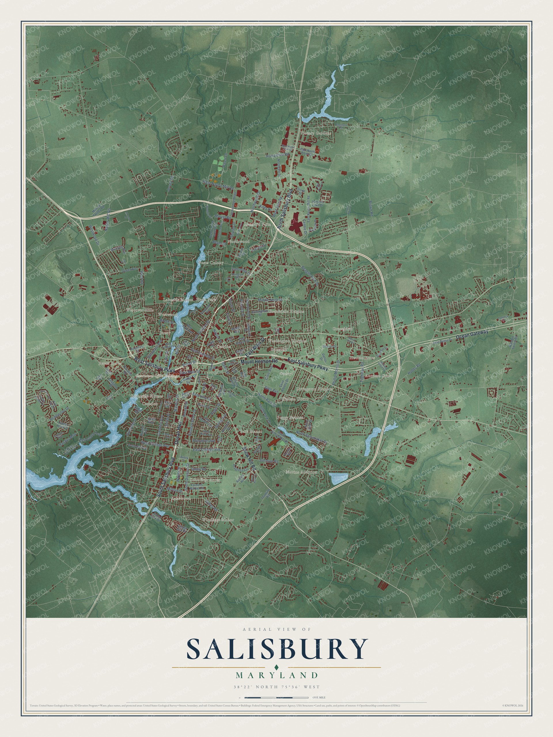
Salisbury, Maryland Map Art
Building by building, with labeled streets and shaded relief.
12" x 18" Archival Matte Print
A Map of Home. A Work of Art.
Explore Salisbury, Maryland from a whole new perspective. Created using aerial imagery and detailed geographic data, this map captures Salisbury building by building, with labeled streets, familiar landmarks, and shaded topographical relief that highlights the natural contours of the landscape.
Combining modern data with the timeless character of a vintage atlas, this map is just as interesting up close as it is beautiful on the wall. Whether you grew up in Salisbury, spent memorable years there, or call it home today, this unique map is a great way to celebrate a place that means something to you. Zoom in on the preview to look for your street, and then order a print to put your memories on the wall.
Three ways to hang it

Unframed archival matte, a black wood frame or a white wood frame.
Up close
Geography Worth Displaying
This map was created using accurate cartographic data and authoritative geographic sources, including the U.S. Geological Survey and the Census Bureau. The map brings together terrain, waterways, roads, and building detail. The majority of the streets are labeled, houses are accurately depicted, and the topography is derived from government sources. Combining local data with carefully composed color and shading leads to this beautifully detailed Salisbury artwork for your wall.
Rather than simply showing street outlines, we’ve included as many of the street names as we could reasonably fit on the map while keeping their names legible. Zoom in on the high resolution preview to see exactly what’s on the map. We truly set out to create a statement piece for anyone who loves Salisbury. So whether it’s for you, or a gift for someone you love, we hope this map of Salisbury brings back fond memories.
Read the story behind this map of Salisbury, Maryland from 2026.

Find your street
Names on the Salisbury map
Every name below is printed on this map. Look for your street, your school, the park where you played, or the pond down the road.
Places and landmarks29
- Government Office Building
- Victory Gardens
- Greenlawn
- Windham Manor
- Nevins Addition
- Leonard Farm
- Sunayr
- Poets Colony
- Camden
- Lakeside Manor
- Foggy Bottom
- Canton
Show all 29 places
- Autumn Grove
- Northwood
- Westover Hills
- Suburban Acres
- Brookdale Heights
- Park Manor
- Pecan Acres
- Washington Heights
- Lakewood
- Chelsea Court
- Westwood
- Jersey
- Hyde Park
- Livingston Heights
- Hotton Acres
- Belmont
- Riverside Homes
Streets and roads167
- Ocean Highway
- North Salisbury Boulevard
- South Salisbury Boulevard
- West Salisbury Parkway
- East Salisbury Parkway
- Ocean Gateway
- Snow Hill Road
- Mount Hermon Road
- East Main Street
- Beaglin Park Drive
- South Division Street
- West Road
- Naylor Mill Road
- Northwood Drive
- South Park Drive
- North Park Drive
- West Naylor Mill Road
- Centre Drive
- Riverside Drive
- Pemberton Drive
- Delaware Avenue
- Camden Avenue
- Lake Street
- North Division Street
- Priscilla Street
- West College Avenue
- Eastern Shore Drive
- East Isabella Street
- Hammond Street
- Marvel Road
Show all 167 streets
- Marquis Avenue
- Truitt Street
- Johnson Road
- North Schumaker Drive
- Roger Street
- Smith Street
- Jersey Road
- Naylor Street
- Waverly Drive
- Glen Avenue
- West Zion Road
- Spring Avenue
- Kiley Drive
- Brown Road
- Middle Neck Drive
- Dykes Road
- East College Avenue
- Paleo Lane
- Mill Street
- Civic Avenue
- Hobbs Road
- Tilghman Road
- Hampshire Road
- East Vine Street
- Wayne Street
- Dover Street
- Bell Island Trail
- Shipley Drive
- Onley Road
- Westwood Drive
- Phillip Morris Drive
- Davis Street
- Milford Street
- Handys Mdw
- Princeton Avenue
- Columbia Drive
- Roland Street
- Broad Street
- Booth Street
- Oak Street
- Beam Street
- Progress Circle
- Long Avenue
- Stone Gate Drive
- East Naylor Mill Road
- East Church Street
- Harbor Point Drive
- South Boulevard
- Emerson Avenue
- Scenic Drive Extended
- John Deere Drive
- Jefferson Street
- South Schumaker Drive
- East Lincoln Avenue
- Foxfield Drive
- Darwin Drive
- Scenic Drive
- Prince Street
- Saint Albans Drive
- Parsons Road
- Armstrong Parkway
- Walston Switch Road
- Canal Park Drive
- Brittingham Street
- Dallas Drive
- Russell Avenue
- East North Point Drive
- Milford Twilley Road
- Robins Avenue
- Northgate Drive
- Ridge Road
- Beaver Dam Drive
- Hemlock Street
- Druid Hill Avenue
- Cross Creek Drive
- Queen Avenue
- Farmers Market Road
- New York Avenue
- Ohio Avenue
- Grace Street
- Overlook Drive
- Village Oak Drive
- Parsons Lake Drive
- Sharen Drive
- Sumac Circle
- Boundary Street
- Ellegood Street
- Sheffield Avenue
- Baker Street
- Fire Fly Drive
- Toadvine Road
- Race Street
- Avery Street
- Times Square
- Stone Street
- Mabel Avenue
- Ward Street
- West Isabella Street
- Windsor Drive
- Comteck Lane
- Mill Pond Lane
- Industrial Parkway
- Anchors Way
- Culver Road
- Park Avenue
- Adams Avenue
- Dagsboro Road
- Arlington Road
- Cotton Patch Island
- Sweetbay Drive
- Alvin Avenue
- West North Point Drive
- Richwil Drive
- Benny Street
- South Haven Avenue
- West Vine Street
- Autumn Grove Court
- Rosalie Way
- Light Street
- Gay Street
- East William Street
- Merritt Mill Road
- Pinehurst Avenue
- Marley Manor Drive
- Cypress Street
- Tarry Town Road
- Oak Hill Avenue
- Moss Hill Lane
- College Lane
- Ed Taylor Road
- Forest Plains Lane
- Marine Road
- Monitor Court
- Legacy Way
- Pond Street
- Bowl Drive
- Liam Drive
Names are listed as they appear on the printed map. Zoom into the product photos to find them.
About Salisbury, Maryland
Salisbury is a city of 33,050 people and the seat of Wicomico County, and it is the largest city on Maryland's Eastern Shore. Lord Baltimore founded it in 1732 as a small outpost at the head of the Wicomico River, a spot that suited traders well. Many historians think its founders named it for Salisbury, England, an old cathedral city with a similar setting.
Salisbury was incorporated as a city in 1854. Fires in 1860 and 1886 burned through two-thirds of the town, but it rebuilt and kept growing. When Wicomico County was formed in 1867 from parts of Somerset and Worcester counties, Salisbury became its seat of government. In 1909 the Humphrey's Dam burst and flooded parts of the city.
- A Union campDuring the Civil War, Union troops camped at Salisbury. From here they searched for people who sided with the South and worked to stop supplies from reaching Confederate forces.
- Poplar Hill, about 1800Poplar Hill Mansion, a Federal Period house from around 1800, is the oldest building still standing in Salisbury. It joined the National Register in 1971.
- Home of Perdue FarmsThe poultry company Perdue Farms has its headquarters in Salisbury. With nearly 22,000 employees, it is the largest employer based in the city, which is also home to Salisbury University.
- All-America City in 2010On June 18, 2010, Salisbury won the All-America City Award for three projects: reviving the Rose and Lake Street neighborhoods, a Youth Leadership Academy for students in grades 8 through 11, and work for the homeless that included the Code Blue Shelter.
Keep exploring Maryland
Salisbury is one of 881 Maryland towns we've mapped. Every dot on the map is a print of its own.
The search covers every state, Maryland first.
Near Salisbury
Order 2 or more town maps and save 10%. Shown in the size and finish you picked above, so they hang as a set.
- Fruitland 12" x 18" / Archival Matte Print $39.99
- Delmar 12" x 18" / Archival Matte Print $39.99
- Parsonsburg 12" x 18" / Archival Matte Print $39.99


More maps nearby: Hebron, Eden, Allen, Quantico and Pittsville.
The art of mapping a place
How This Map Was Made
Real places. Remarkable detail. Discover the layers that turn geographic data into a map of home.

The view from above
Aerial imagery reveals the character of the land: woodland, open fields, and the patterns of a place.

The shape of the land
Elevation data brings hills, valleys, and subtle changes in the landscape into view.

The details of home
Roads, waterways, and building footprints come together to make the map feel unmistakably local.

Geography becomes art
Considered color, shading, and typography bring the layers together in a map made for your wall.


Process illustrated with Mendon, Massachusetts. Aerial imagery: USDA NAIP. Terrain: USGS 3D Elevation Program. Map details and finished artwork: KNOWOL.
The Details
About This Print
Choose an archival matte print, or a black or white Ayous wood frame. The archival matte print is unframed.
Select your size and finish above to see the matching product image and price.
Materials & Craftsmanship
A contemporary map with the character of a classic atlas, printed on archival matte paper. Optional frames are made from Ayous wood.
Your printed map does not include the watermark shown in the full-map preview.
Shipping & Delivery
Free shipping within the United States. Every print is made to order in the USA.
Buying a gift? Add a note in your cart and we'll include it. We never put prices in the package.
Prints ship within 2 to 3 business days. Allow 7 to 10 days total from ordering for delivery. Timing may vary during holidays or periods of high order volume.
Read our shipping policy.
Returns and damaged prints
Each print is made to order. Change-of-mind refunds are not available after production.
If your print arrives damaged, misprinted or incorrect, contact support@knowol.com within 30 days of receiving it. Include your order number, photos and a description of the issue.
Read our full refund and replacement policy. For questions about your order, email support@knowol.com.