
Search for another town


Free U.S. delivery 7 to 10 days after you order
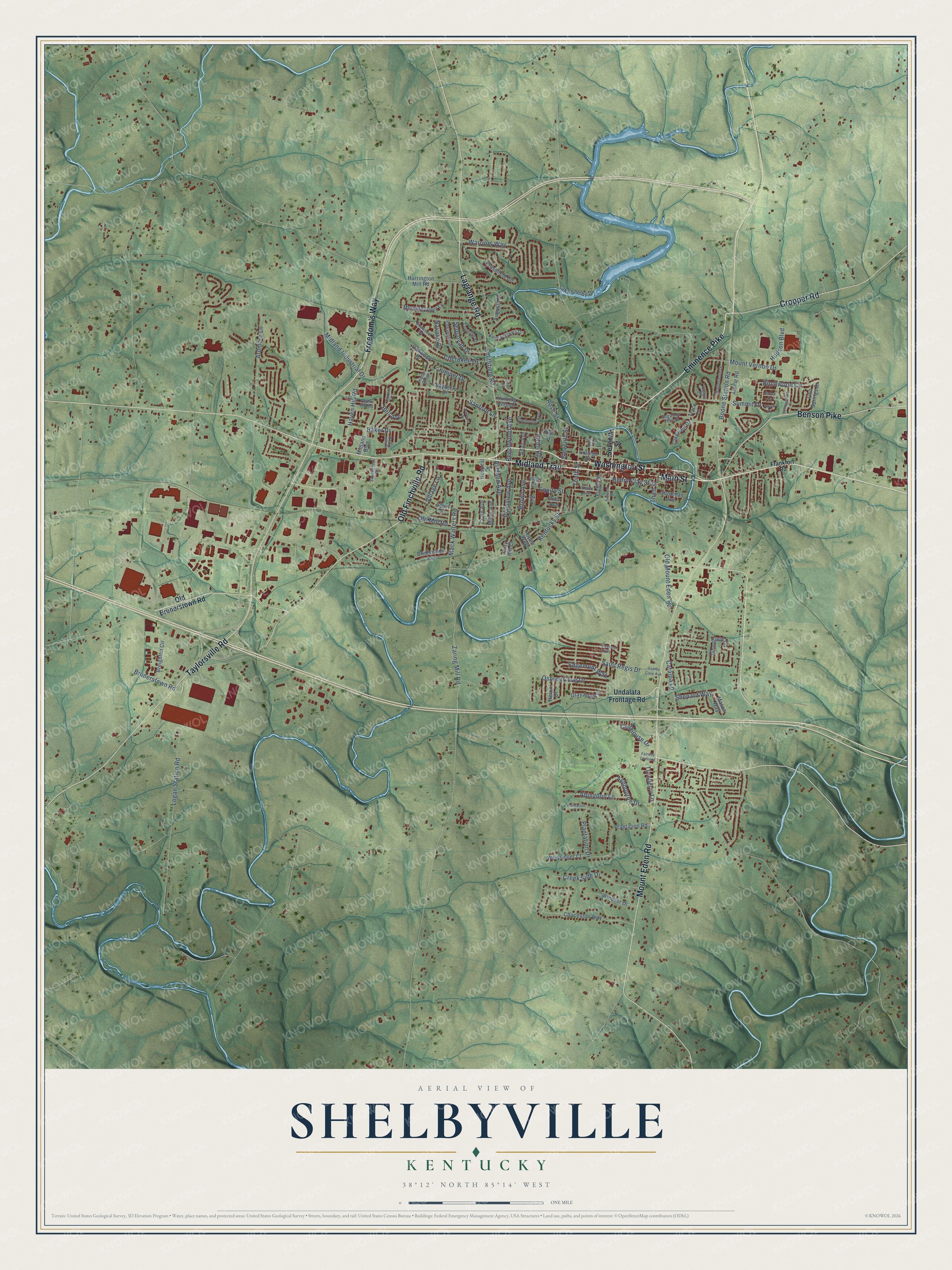
Shelbyville, Kentucky Map Art
Building by building, with labeled streets and shaded relief.
12" x 18" Archival Matte Print
A Map of Home. A Work of Art.
Explore Shelbyville, Kentucky from a whole new perspective. Created using aerial imagery and detailed geographic data, this map captures Shelbyville building by building, with labeled streets, familiar landmarks, and shaded topographical relief that highlights the natural contours of the landscape.
Combining modern data with the timeless character of a vintage atlas, this map is just as interesting up close as it is beautiful on the wall. Whether you grew up in Shelbyville, spent memorable years there, or call it home today, this unique map is a great way to celebrate a place that means something to you. Zoom in on the preview to look for your street, and then order a print to put your memories on the wall.
Three ways to hang it

Unframed archival matte, a black wood frame or a white wood frame.
Up close
Geography Worth Displaying
This map was created using accurate cartographic data and authoritative geographic sources, including the U.S. Geological Survey and the Census Bureau. The map brings together terrain, waterways, roads, and building detail. The majority of the streets are labeled, houses are accurately depicted, and the topography is derived from government sources. Combining local data with carefully composed color and shading leads to this beautifully detailed Shelbyville artwork for your wall.
Rather than simply showing street outlines, we’ve included as many of the street names as we could reasonably fit on the map while keeping their names legible. Zoom in on the high resolution preview to see exactly what’s on the map. We truly set out to create a statement piece for anyone who loves Shelbyville. So whether it’s for you, or a gift for someone you love, we hope this map of Shelbyville brings back fond memories.
Read the story behind this map of Shelbyville, Kentucky from 2026.

Find your street
Names on the Shelbyville map
Every name below is printed on this map. Look for your street, your school, the park where you played, or the pond down the road.
Streets and roads123
- Main Street
- Washington Street
- Eminence Pike
- Freedom's Way
- Midland Trail
- Mount Eden Road
- Lagrange Road
- Benson Pike
- Cropper Road
- Taylorsville Road
- Old Finchville Road
- Smithfield Road
- Boone Station Road
- Ashland Avenue
- Edgemont Way
- Plantation Drive
- Zaring Mill Road
- Kentucky Street
- Henry Clay Street
- Mack Walters Road
- Saint Regis Drive
- Brunerstown Road
- Logan Station Road
- Haven Hill Road
- Creek Side Drive
- Warriors Way
- Juniper Drive
- Ardmore Lane
- Birchwood Circle
- Ashbourne Drive
Show all 123 streets
- Midland Industrial Drive
- Bell Avenue
- Old Mount Eden Road
- Osprey Cove Drive
- Eleventh Street
- Plainview Avenue
- Abingdon Lane
- Cherokee Drive
- Mount Vernon Drive
- Summit Drive
- Brown Avenue
- Clubhouse Drive
- Sequoyah Drive
- Rose Street
- Old Mill Road
- Beechwood Avenue
- Village Lane
- Tenth Street
- Sanford Lane
- Turnberry Lane
- Shepard Way
- Hudson Boulevard
- Baker Drive
- Catalpa Lane
- Alton Road
- Navaho Drive
- Third Street
- Equity Street
- Seventh Street
- Undalata Frontage Road
- Old Brunerstown Road
- Charleston Way
- Harrington Mill Road
- Midland Boulevard
- Breighton Circle
- Woodfield Circle
- Morning Glory Lane
- Lakeview Drive
- Gray Hawk Drive
- Augusta Drive
- Eighth Street
- Bridlewood Avenue
- Lake Shelby Drive
- Alpine Road
- College Street
- Two Springs Drive
- Bayberry Drive
- Weissinger Court
- Plantation Road
- High Street
- Trace Lane
- Brassfield Circle
- Oakwood Drive
- Adair Avenue
- Goodman Avenue
- Hunting Hills Drive
- Windsor Drive
- Craig Avenue
- Miller Avenue
- Heron Drive
- Mason Way
- Hospital Drive
- Vine Street
- Aspen Way
- Short Street
- Gray Hill Court
- Ada Avenue
- Frankfort Road
- Saint Andrews Drive
- Hawthorne Avenue
- Cheyenne Drive
- Matterhorn Drive
- Dogwood Villa Drive
- Poplar Hill Road
- Shawnee Road
- Indian Ridge
- Bland Avenue
- Stonecrest Road
- Nordic Court
- Osprey Cove Avenue
- Ninth Street
- Fairway Crossing
- Summerfield Drive
- Comanche Road
- Cardinal Drive
- Firestone Way
- Oak Street
- Plantation Court
- Forest Hills Drive
- Raven Court
- Cypress Court
- Circle Drive
- Clover Lane
Names are listed as they appear on the printed map. Zoom into the product photos to find them.
About Shelbyville, Kentucky
Shelbyville is a city of 17,282 people and the county seat of Shelby County. The Shelby County Court held its first session in October 1792, and there landowner William Shannon agreed to give up 50 acres for a town and 1 more acre for public buildings. Because of his gift, the county seat went to Shelbyville instead of nearby Squire Boone's Station. Each new family had to put up a log cabin a story and a half tall, its chimney built of stone, and 40 of those cabins stood by 1795. The town had 262 residents by 1800.
On August 24, 1864, Confederate guerrillas led by Captain Dave Martin raided the courthouse to take the muskets stored there. Two townsmen, the merchant Thomas McGrath and the tailor J. H. Masonheimer, drove them off and killed three of the raiders. The town then made its white men over 18 serve as guards and built a blockhouse at Fifth and Main. Once the raids were over, the blockhouse came down by September of the next year.
“Prior to the Civil War, Shelbyville supported Shelby College and three female schools.”
- Science Hill, 1825 to 1939The Science Hill Female Academy opened on Washington Street in 1825. For more than a century it got young women from across the South ready for college. The Great Depression was drawing to a close when the school finally shut in 1939. Shelby College began as the Shelbyville Academy in 1798 and shut its doors in 1871.
- The railroad came in 1870The Shelby Railroad Company ran a line to Anchorage in 1870, linking the town to the main line of the Louisville, Cincinnati and Lexington Railroad. Farmers here raised corn, hemp, tobacco, wheat, hogs and cattle, and the town boomed. Many ornate downtown buildings went up after a big fire in 1909. The Shelbyville L & N Railroad Depot joined the National Register in 1975.
- Saddlebred Capital of the WorldShelbyville calls itself the Saddlebred Capital of the World. It holds the Shelbyville Horse Show every year, and the yearly Dogwood Festival brings in visitors for arts and crafts.
- Kentucky's coldest dayOn January 19, 1994, the temperature in Shelbyville dropped to 37 degrees below zero Fahrenheit. No place in Kentucky has ever recorded a colder reading.
- Colonel Sanders lived hereColonel Sanders, the founder of Kentucky Fried Chicken, made his home in Shelbyville from 1960 until he died in 1980. Martha Layne Collins, the first woman to serve as governor of Kentucky, is also from the town.
Keep exploring Kentucky
Shelbyville is one of 659 Kentucky towns we've mapped. Every dot on the map is a print of its own.
The search covers every state, Kentucky first.
Near Shelbyville
Order 2 or more town maps and save 10%. Shown in the size and finish you picked above, so they hang as a set.
- Simpsonville 12" x 18" / Archival Matte Print $39.99
- Elk Creek 12" x 18" / Archival Matte Print $39.99
- Eminence 12" x 18" / Archival Matte Print $39.99


More maps nearby: Pleasureville, Smithfield, Taylorsville, Centerfield and La Grange.
The art of mapping a place
How This Map Was Made
Real places. Remarkable detail. Discover the layers that turn geographic data into a map of home.

The view from above
Aerial imagery reveals the character of the land: woodland, open fields, and the patterns of a place.

The shape of the land
Elevation data brings hills, valleys, and subtle changes in the landscape into view.

The details of home
Roads, waterways, and building footprints come together to make the map feel unmistakably local.

Geography becomes art
Considered color, shading, and typography bring the layers together in a map made for your wall.


Process illustrated with Mendon, Massachusetts. Aerial imagery: USDA NAIP. Terrain: USGS 3D Elevation Program. Map details and finished artwork: KNOWOL.
The Details
About This Print
Choose an archival matte print, or a black or white Ayous wood frame. The archival matte print is unframed.
Select your size and finish above to see the matching product image and price.
Materials & Craftsmanship
A contemporary map with the character of a classic atlas, printed on archival matte paper. Optional frames are made from Ayous wood.
Your printed map does not include the watermark shown in the full-map preview.
Shipping & Delivery
Free shipping within the United States. Every print is made to order in the USA.
Buying a gift? Add a note in your cart and we'll include it. We never put prices in the package.
Prints ship within 2 to 3 business days. Allow 7 to 10 days total from ordering for delivery. Timing may vary during holidays or periods of high order volume.
Read our shipping policy.
Returns and damaged prints
Each print is made to order. Change-of-mind refunds are not available after production.
If your print arrives damaged, misprinted or incorrect, contact support@knowol.com within 30 days of receiving it. Include your order number, photos and a description of the issue.
Read our full refund and replacement policy. For questions about your order, email support@knowol.com.