
Search for another town


Free U.S. delivery 7 to 10 days after you order
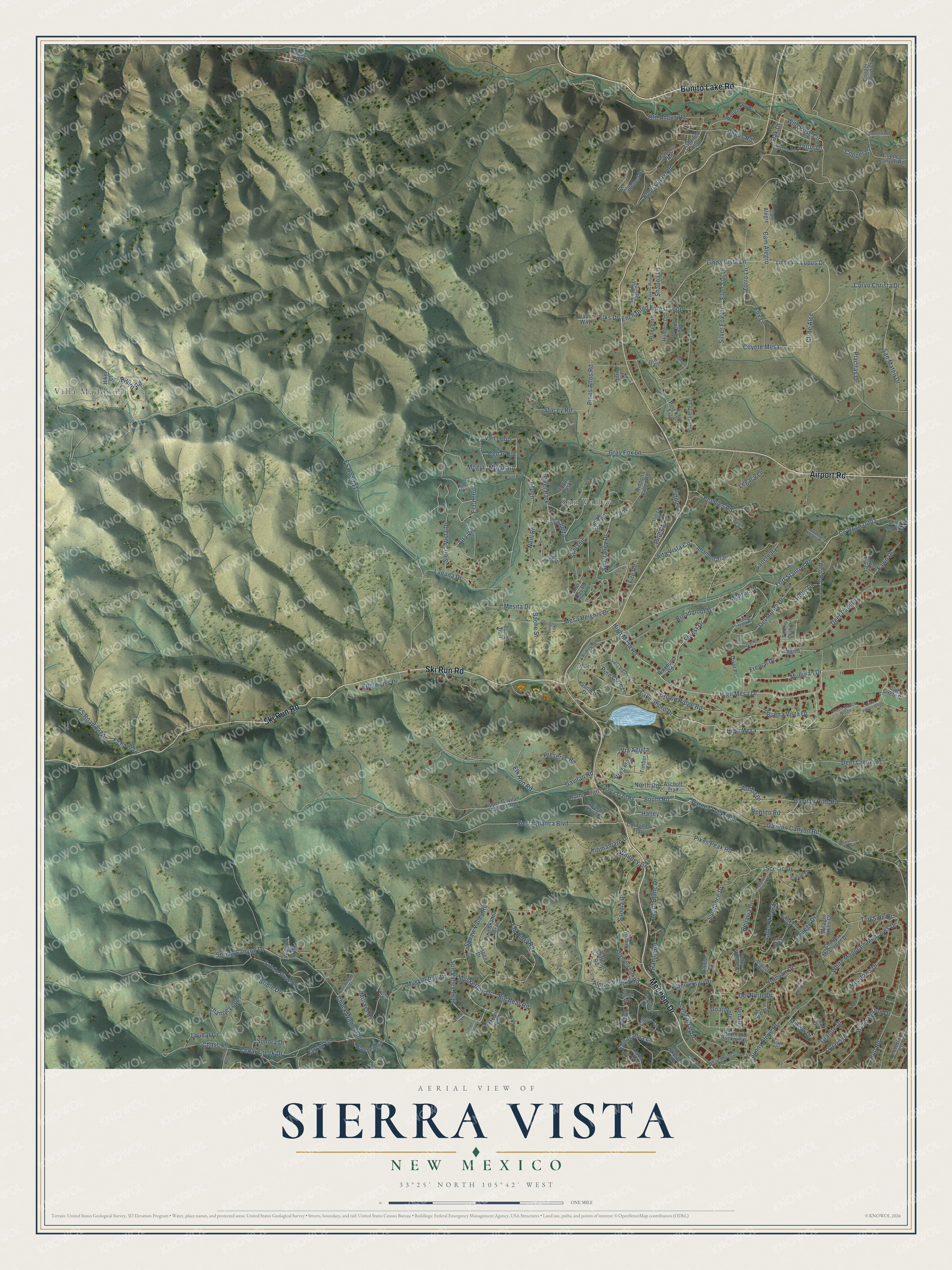
Sierra Vista, New Mexico Map Art
Building by building, with labeled streets and shaded relief.
12" x 18" Archival Matte Print
A Map of Home. A Work of Art.
Explore Sierra Vista, New Mexico from a whole new perspective. Created using aerial imagery and detailed geographic data, this map captures Sierra Vista building by building, with labeled streets, familiar landmarks, and shaded topographical relief that highlights the natural contours of the landscape.
Combining modern data with the timeless character of a vintage atlas, this map is just as interesting up close as it is beautiful on the wall. Whether you grew up in Sierra Vista, spent memorable years there, or call it home today, this unique map is a great way to celebrate a place that means something to you. Zoom in on the preview to look for your street, and then order a print to put your memories on the wall.
Three ways to hang it

Unframed archival matte, a black wood frame or a white wood frame.
Up close
Geography Worth Displaying
This map was created using accurate cartographic data and authoritative geographic sources, including the U.S. Geological Survey and the Census Bureau. The map brings together terrain, waterways, roads, and building detail. The majority of the streets are labeled, houses are accurately depicted, and the topography is derived from government sources. Combining local data with carefully composed color and shading leads to this beautifully detailed Sierra Vista artwork for your wall.
Rather than simply showing street outlines, we’ve included as many of the street names as we could reasonably fit on the map while keeping their names legible. Zoom in on the high resolution preview to see exactly what’s on the map. We truly set out to create a statement piece for anyone who loves Sierra Vista. So whether it’s for you, or a gift for someone you love, we hope this map of Sierra Vista brings back fond memories.
Read the story behind this map: Detailed Map of Sierra Vista, New Mexico.

Find your street
Names on the Sierra Vista map
Every name below is printed on this map. Look for your street, your school, the park where you played, or the pond down the road.
Places and landmarks4
- Villa Madonna
- Alto
- Sun Valley
- Deer Park
Streets and roads231
- Bonito Lake Road
- Ski Run Road
- Mechem Drive
- Airport Road
- High Mesa
- Lake Shore Drive
- High Mesa Drive
- Linda Vista Lane
- High Mesa Road
- Cll de Alce
- Coyote Mesa
- Mulligan Drive
- South Road
- Alto Road
- Barney Luck Trail
- Alpine Village Road
- Silver Fox Lane
- Lupus Drive
- Vail Loop
- Mogul Road
- Fort Stanton Road
- Sun Valley Trail
- Mogul
- Halley
- Scenic Drive
- University Drive
- Teton Drive
- Sun Valley Drive
- Wild Rose Circle
- El Centro
Show all 231 streets
- Sanctuary
- Musket Ball Drive
- Mont Blanc Drive
- Elk Run Road
- Midiron Drive
- Taos
- Edelweiss Drive
- Rillito Road
- Sierra Blanca Boulevard
- Big Bear Road
- Musketball Drive
- La Junta
- FS Road 117
- Gavilan Canyon Road
- White Mountain Meadows Drive
- Cedar Creek Drive
- Bonita Park Road
- Alta Vista Circle
- Bridle Drive
- Enchanted Forest Loop
- Placitas Drive
- Sunny Slope Drive
- Chance Loop
- College Drive
- Crown Ridge Road
- Deer Park Drive
- Valley View Drive
- Chuck Wagon Road
- Gavilan Hills Road
- Del Monte Drive
- Pikes Peak Road
- Fox Lane
- Deer Creek Road
- San Mateo Drive
- Buena Vista Drive
- Hull Road
- Gavilan Road
- Del Norte Drive
- Willie Horton Drive
- French Drive
- Granite Drive
- Broadmoor Drive
- Bellavia Circle
- Mesa Heights Drive
- Old Angus Road
- Gray Fox Lane
- Peebles Road
- Forest Drive
- Jarratt Drive
- Sierra Vista Drive
- Leon Farrar Drive
- Marble Drive
- Sandia Drive
- Laguna Drive
- Sundance Drive
- Legacy Lane
- Meadows Drive
- Pinos Altos Road
- North Road
- Spring Canyon Drive
- Kilimanjaro Drive
- Corvo Christa Drive
- Stacey Road
- Convair Drive
- Alta Vis
- Roblito Road
- Fawn Drive
- Musket Court
- Zorro Lane
- Neill Road
- Pine Cone Lane
- Preserve Road
- Sonora Drive
- Angus Road
- Ranier Road
- Loudat Lane
- Tall Pines Road
- Via Aguila
- Shauna Lane
- Mesita Drive
- Via Selva
- Top Side Drive
- Elks Drive
- Chiracahua Lane
- Holly Drive
- Fire Road
- Aspen
- Venado
- Whitney Drive
- Guajolote
- Pine Court
- Cam Alegro
- Cedar Road
- Bache Street
- Fiddler Lane
- Poma Trail
- Copper Court
- Arriba Drive
- Chase Lane
- Sunland
- Oak Drive
- Linda Vis
- Club Circle Drive
- Silver Star Lane
- Alto Alps Road
- Tennis Club Drive
- Ashwood Loop
- Altamont Trail
- Upper Gavilan Canyon Road
- FS Road 127
- Sequoia Drive
- Charles McClellan Drive
- Pine Hill Trail
- Eaglenest Road
- Pinehurst Road
- Hidden Valley Road
- Saddle Slope Road
- Aschoff Trail
- Snow Park Road
- Aspen Drive
- Olympia Road
- Raymond Buckner Drive
- Bluebelle Lane
- Cliffside Road
- Ll Davis Drive
- Sunset Drive
- Canyon Road
- Valley View Circle
- Timber Lane
- Cam Alegre
- Cibola Circle
- Copper Canyon Road
- Ballpark Loop
- Skylane Road
- Milagro Hills Court
- Copper Cloud Court
- Wapiti Way
- Mulberry Road
- Apache Bowl Court
- Timberline Court
- Sandia Road
- Hiker Court
- Stag Loop Road
- Poma Trail Road
- Kaibab Drive
- Pine Shadow Trail
- Alamo Drive
- Hunters Lane
- Pine Knot Trail
- Pronghorn
- Cornudas Trail
- Tennis Court
- Circle Drive
- Mount Hood
- Sugar Bush
- Coal Drive
- Big Sky Lane
- Bull Elk Court
- Tahoe Drive
- Watson Road
- English Road
- Coggins Court
- Burro Trail
- Divot Place
- Doris Lane
- Brentwood Drive
- Pidea Vis
- Two Tract Road
- La Junta Drive
- White Mountain Drive
- Thistle Road
- Screaming Eagle Drive
- Moon Dance Ridge
- Meadow Wood
- Andrea Road
- Silver Star Court
- Slate Court
- Alto Drive
- Sunlit Court
- Otter Court
- Flute Player Way
- Vail Trail
- Sun Valley Road
- Sierra Blanca Drive
- Bonanza Drive
- Rango Loop
- Raven Ridge Drive
- Gun Powder Trail
- Ravens Wing Drive
- East View Drive
- Taos Road
- Bellavia Circle Drive
- Flintlock Trail
- Cottonwood Court
- Sparrow Hawk
- Bonnie Court
- Stanton Meadow Lane
- High Chaparral
- Augusta Court
- South Slope Court
- Badger Court
Names are listed as they appear on the printed map. Zoom into the product photos to find them.
Keep exploring New Mexico
Sierra Vista is one of 544 New Mexico towns we've mapped. Every dot on the map is a print of its own.
The search covers every state, New Mexico first.
Near Sierra Vista
Order 2 or more town maps and save 10%. Shown in the size and finish you picked above, so they hang as a set.
- Ruidoso 12" x 18" / Archival Matte Print $39.99
- Ruidoso Downs 12" x 18" / Archival Matte Print $39.99
- Nogal 12" x 18" / Archival Matte Print $39.99


More maps nearby: Capitan, Carrizozo, Mescalero, Bent and Hondo.
The art of mapping a place
How This Map Was Made
Real places. Remarkable detail. Discover the layers that turn geographic data into a map of home.

The view from above
Aerial imagery reveals the character of the land: woodland, open fields, and the patterns of a place.

The shape of the land
Elevation data brings hills, valleys, and subtle changes in the landscape into view.

The details of home
Roads, waterways, and building footprints come together to make the map feel unmistakably local.

Geography becomes art
Considered color, shading, and typography bring the layers together in a map made for your wall.


Process illustrated with Mendon, Massachusetts. Aerial imagery: USDA NAIP. Terrain: USGS 3D Elevation Program. Map details and finished artwork: KNOWOL.
The Details
About This Print
Choose an archival matte print, or a black or white Ayous wood frame. The archival matte print is unframed.
Select your size and finish above to see the matching product image and price.
Materials & Craftsmanship
A contemporary map with the character of a classic atlas, printed on archival matte paper. Optional frames are made from Ayous wood.
Your printed map does not include the watermark shown in the full-map preview.
Shipping & Delivery
Free shipping within the United States. Every print is made to order in the USA.
Buying a gift? Add a note in your cart and we'll include it. We never put prices in the package.
Prints ship within 2 to 3 business days. Allow 7 to 10 days total from ordering for delivery. Timing may vary during holidays or periods of high order volume.
Read our shipping policy.
Returns and damaged prints
Each print is made to order. Change-of-mind refunds are not available after production.
If your print arrives damaged, misprinted or incorrect, contact support@knowol.com within 30 days of receiving it. Include your order number, photos and a description of the issue.
Read our full refund and replacement policy. For questions about your order, email support@knowol.com.