


Search for another town


Free U.S. delivery 7 to 10 days after you order
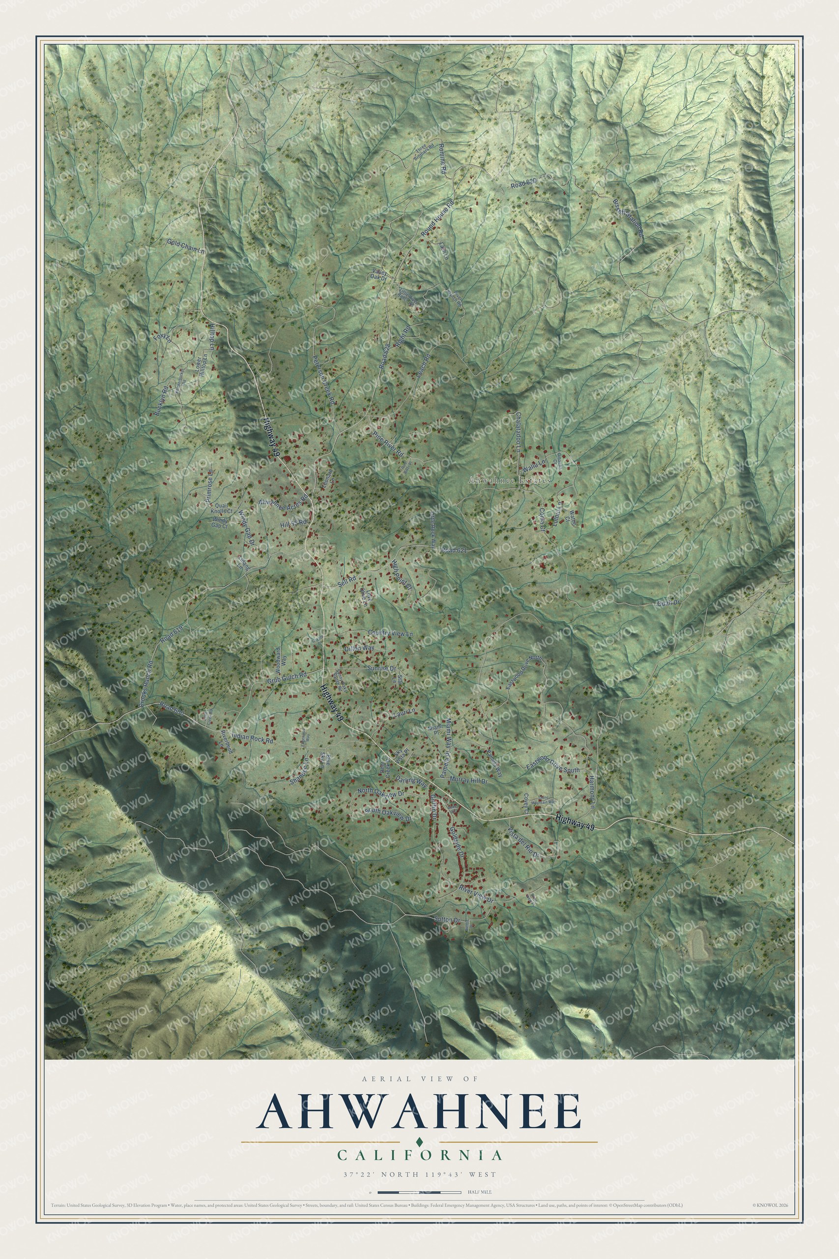
Ahwahnee, California Map Art
Building by building, with labeled streets and shaded relief.
12" x 18" Archival Matte Print
A Map of Home. A Work of Art.
Explore Ahwahnee, California from a whole new perspective. Created using aerial imagery and detailed geographic data, this map captures Ahwahnee building by building, with labeled streets, familiar landmarks, and shaded topographical relief that highlights the natural contours of the landscape.
Combining modern data with the timeless character of a vintage atlas, this map is just as interesting up close as it is beautiful on the wall. Whether you grew up in Ahwahnee, spent memorable years there, or call it home today, this unique map is a great way to celebrate a place that means something to you. Zoom in on the preview to look for your street, and then order a print to put your memories on the wall.
Three ways to hang it

Unframed archival matte, a black wood frame or a white wood frame.
Up close
Geography Worth Displaying
This map was created using accurate cartographic data and authoritative geographic sources, including the U.S. Geological Survey and the Census Bureau. The map brings together terrain, waterways, roads, and building detail. The majority of the streets are labeled, houses are accurately depicted, and the topography is derived from government sources. Combining local data with carefully composed color and shading leads to this beautifully detailed Ahwahnee artwork for your wall.
Rather than simply showing street outlines, we’ve included as many of the street names as we could reasonably fit on the map while keeping their names legible. Zoom in on the high resolution preview to see exactly what’s on the map. We truly set out to create a statement piece for anyone who loves Ahwahnee. So whether it’s for you, or a gift for someone you love, we hope this map of Ahwahnee brings back fond memories.
Read the story behind this map of Ahwahnee, California from 2026.

Find your street
Names on the Ahwahnee map
Every name below is printed on this map. Look for your street, your school, the park where you played, or the pond down the road.
Places and landmarks1
- Ahwahnee Estates
Streets and roads83
- Highway 49
- Round House Road
- Pine River Road
- Coma Court
- Opah Drive
- Road 628
- Leach Road
- Road 621
- Crooks Ranch Road
- Road 619
- Pamela Place
- Grub Gulch Road
- Road 600
- Peterson Creek Road
- Bissett Station Road
- Road 620
- Sell Road
- Indian Rock Road
- Romine Road
- Goldside Drive
- Wallu Lane
- High Point Court
- Griffin Drive
- Windy Gap Drive
- South Oakview Drive
- Dillon Way
- Sunrise Drive
- Country View Lane
- Vista del Rio Drive
- River View Drive
Show all 83 streets
- Eastwood Drive South
- North Oakview Drive
- Chalatadoo Lane
- Sutton Drive
- Bucklyn Road
- Lauri Lane
- Lulniu Lane
- Harmony Lane
- Ahwahnee Acres Road
- Shandee Lane
- Murray Hill Drive
- Right Road
- Gold Chain Lane
- Hilltop Lane
- Primrose Lane
- Miami Way
- Darling Way
- Hill 55 Road
- Foxy Lane
- Valley Oak Drive
- Eastwood Drive North
- Woodward Way
- Lower Hilltop Lane
- Quail Knolls Court
- Lash Lane
- Windy Gap Court
- Little Rock Way
- Love Olive Lane
- Pamela Way
- Leonard Lane
- Riverbend Lane
- Watoo Court
- Deer Creek Drive
- Miami Place
- Blue Sky Lane
- Sky Vista Place
- Covey Court
- Lulang Lane
- Star Lane
- Three Brothers Road
- Little River Ranch Road
- River Ranch Road
- Sunny Oaks Ranch Road
- Omacha Court
- Knickerbocker Road
- Stone Mountain Way
- Edgewood Way
- Little Creek Road
- Pine River Place
- Coyote Lane
- River View Place
- Sutton Place
- Duke Circle
Names are listed as they appear on the printed map. Zoom into the product photos to find them.
About Ahwahnee, California
Ahwahnee is a community of 2,296 people in Madera County, at 2,326 feet in the western foothills of the Sierra Nevada. Southern Sierra Miwok families lived here for thousands of years, and their village on Wassama Creek was called Wasa'ma. Miners and settlers came into the southern Sierra beginning in 1849 with the Gold Rush, and they pushed Native communities off much of their land.
In April 1892 Albert Henry Washburn, who ran the Yosemite Stage Line, bought 320 acres of the old Cassell ranch for a way station on the road from Raymond to Wawona. In 1899 he and William M. Sell, Sr. opened the two-story Ahwahnee Tavern as the halfway stop on the one-day ride to Yosemite, and Mary Peck Sell suggested its name. Stage traffic declined once the Yosemite Valley Railroad arrived at El Portal in 1907, giving visitors a faster route into the park.
- Roosevelt stopped for lunchTheodore Roosevelt ate lunch at the Ahwahnee Tavern on May 7, 1903, while he was traveling to Yosemite to meet John Muir. Accounts from that era say the inn also hosted Andrew Carnegie, Susan B. Anthony, Crown Prince Albert of Belgium and John D. Rockefeller.
- The Wassama RoundhouseA roundhouse stood at Wassama by 1858. Another, put up in the 1880s, was set on fire in 1893 when its chief died, and the next, raised in 1903, reused pieces of the center pole from the two earlier ones. Chief Peter Westfall asked that it be spared when he died in 1924, and he lay in state inside.
- From Gertrude to AhwahneeGertrude, a nearby settlement, got a post office in 1881. It was named for the wife of John Haley, who owned the Enterprise Mine. In 1900 the post office was moved 2 miles to the north and renamed Ahwahnee, after the Native name for Yosemite Valley and its largest village.
- A sanatorium for 50 yearsIn 1918 Madera, Merced and Stanislaus counties bought 480 acres here, including 320 from the Sell family, for a tuberculosis hospital that opened in 1919. The old tavern became its kitchen and office until fire destroyed it in 1937, and by the 1930s more than 100 patients lived on the grounds. The sanatorium closed in 1969, a boys' school used the campus from 1970 to 1985, and the 241-acre Ahwahnee Hills Regional Park opened there in 2014.
- The Harlow Fire of 1961The Harlow Fire swept through in 1961 and burned 50 of the 60 buildings in Ahwahnee. Two residents died when their car got stuck on a dirt road while they were trying to escape. The community rebuilt after the fire.
Keep exploring California
Ahwahnee is one of 1,990 California towns we've mapped. Every dot on the map is a print of its own.
The search covers every state, California first.
Near Ahwahnee
Order 2 or more town maps and save 10%. Shown in the size and finish you picked above, so they hang as a set.
- Nipinnawasee 12" x 18" / Archival Matte Print $39.99
- Oakhurst 12" x 18" / Archival Matte Print $39.99
- Bass Lake 12" x 18" / Archival Matte Print $39.99


More maps nearby: Coarsegold, Fish Camp, Bootjack, Yosemite Lakes and Wawona.
The art of mapping a place
How This Map Was Made
Real places. Remarkable detail. Discover the layers that turn geographic data into a map of home.

The view from above
Aerial imagery reveals the character of the land: woodland, open fields, and the patterns of a place.

The shape of the land
Elevation data brings hills, valleys, and subtle changes in the landscape into view.

The details of home
Roads, waterways, and building footprints come together to make the map feel unmistakably local.

Geography becomes art
Considered color, shading, and typography bring the layers together in a map made for your wall.


Process illustrated with Mendon, Massachusetts. Aerial imagery: USDA NAIP. Terrain: USGS 3D Elevation Program. Map details and finished artwork: KNOWOL.
The Details
About This Print
Choose an archival matte print, or a black or white Ayous wood frame. The archival matte print is unframed.
Select your size and finish above to see the matching product image and price.
Materials & Craftsmanship
A contemporary map with the character of a classic atlas, printed on archival matte paper. Optional frames are made from Ayous wood.
Your printed map does not include the watermark shown in the full-map preview.
Shipping & Delivery
Free shipping within the United States. Every print is made to order in the USA.
Buying a gift? Add a note in your cart and we'll include it. We never put prices in the package.
Prints ship within 2 to 3 business days. Allow 7 to 10 days total from ordering for delivery. Timing may vary during holidays or periods of high order volume.
Read our shipping policy.
Returns and damaged prints
Each print is made to order. Change-of-mind refunds are not available after production.
If your print arrives damaged, misprinted or incorrect, contact support@knowol.com within 30 days of receiving it. Include your order number, photos and a description of the issue.
Read our full refund and replacement policy. For questions about your order, email support@knowol.com.