


Search for another town


Free U.S. delivery 7 to 10 days after you order
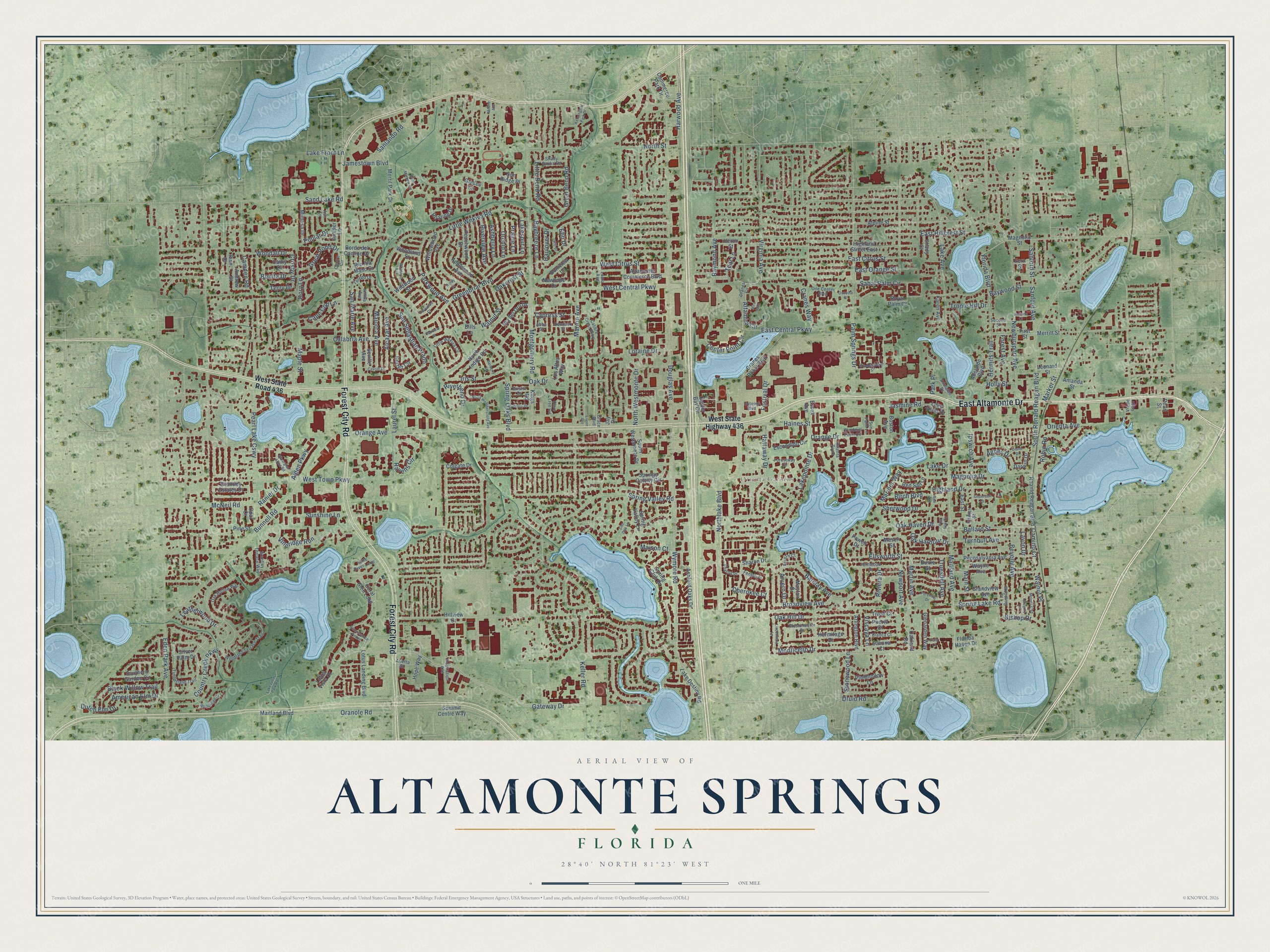
Altamonte Springs, Florida Map Art
Building by building, with labeled streets and shaded relief.
12" x 18" Archival Matte Print
A Map of Home. A Work of Art.
Explore Altamonte Springs, Florida from a whole new perspective. Created using aerial imagery and detailed geographic data, this map captures Altamonte Springs building by building, with labeled streets, familiar landmarks, and shaded topographical relief that highlights the natural contours of the landscape.
Combining modern data with the timeless character of a vintage atlas, this map is just as interesting up close as it is beautiful on the wall. Whether you grew up in Altamonte Springs, spent memorable years there, or call it home today, this unique map is a great way to celebrate a place that means something to you. Zoom in on the preview to look for your street, and then order a print to put your memories on the wall.
Three ways to hang it

Unframed archival matte, a black wood frame or a white wood frame.
Up close
Geography Worth Displaying
This map was created using accurate cartographic data and authoritative geographic sources, including the U.S. Geological Survey (USGS) and FEMA. The map brings together terrain, waterways, roads, and building detail. The majority of the streets are labeled, houses are accurately depicted, and the topography is derived from government sources. Combining local data with carefully composed color and shading leads to this beautifully detailed Altamonte Springs artwork for your wall.
Rather than simply showing street outlines, we’ve included as many of the street names as we could reasonably fit on the map while keeping their names legible. Zoom in on the high resolution preview to see exactly what’s on the map. We truly set out to create a statement piece for anyone who loves Altamonte Springs. So whether it’s for you, or a gift for someone you love, we hope this map of Altamonte Springs brings back fond memories.
Explore the full map of Altamonte Springs, Florida and read about the local places it shows.

Find your street
Names on the Altamonte Springs map
Every name below is printed on this map. Look for your street, your school, the park where you played, or the pond down the road.
Places and landmarks2
- Merrill Park
- Orienta Gardens
Streets and roads300
- East Altamonte Drive
- Forest City Road
- Spring Lake Road
- Ballard Street
- Orange Drive
- Haines Street
- Oak Haven Drive
- Hattaway Drive
- San Sebastian Prado
- Maitland Avenue
- Wymore Road
- Laurel Street
- Oak Hill Drive
- Gateway Drive
- Montgomery Road
- Douglas Avenue
- Little Wekiva Road
- Oranole Road
- Spring Oaks Boulevard
- Country Creek Parkway
- Northlake Boulevard
- Palm Springs Drive
- Jamestown Boulevard
- Florida Boulevard
- East Central Parkway
- Hermits Trail
- Newburyport Avenue
- West Central Parkway
- Pearl Lake Causeway
- Orienta Avenue
Show all 300 streets
- Lake Avenue
- West Town Parkway
- Vineridge Run
- Greenbriar Boulevard
- Sabal Palm Circle
- Cranes Way
- Barclay Avenue
- Altamira Circle
- Ravens Circle
- Stonewood Lane
- Orange Avenue
- Sunshine Lane
- South Ronald Reagan Boulevard
- East Hillcrest Street
- Robin Road
- Ellsworth Street
- Magnolia Drive
- Center Point Circle
- Bunnell Road
- Eden Park Avenue
- Alden Parkway
- Festival Drive
- Sand Lake Road
- Majorca Avenue
- North Westmonte Drive
- Great Pond Drive
- Lakepointe Drive
- East Orange Street
- Beverly Avenue
- Black Willow Trail
- North Street
- Monticello Drive
- Marion Avenue
- Sherwood Drive
- Ipswich Avenue
- Parkwood Avenue
- Calabria Avenue
- Little Bend Road
- Harwood Avenue
- American Elm Drive
- West Citrus Street
- Forest Avenue
- Highland Drive
- Iris Street
- Mariner Way
- Turnbull Avenue
- Lake Drive
- Broadview Avenue
- Riviera Drive
- Sanford Street
- Great Bend Road
- Leatherwood Drive
- Riverbend Drive
- Alcazar Avenue
- East Citrus Street
- Baybreeze Lane
- Riverview Avenue
- Sanlando Road
- Oak Harbour Drive
- Cape Cod Lane
- Main Street
- Walnut Place
- Ashberry Lane
- Orchid Lane
- Raymond Avenue
- Dutch Elm Drive
- Spring Valley Road
- Woodall Drive
- Birch Boulevard
- Cherokee Court
- Marker Street
- McNeil Road
- Maison Court
- Virginia Avenue
- Cypress Street
- Dory Lane
- Keller Road
- Loraine Drive
- Poplar Drive
- Maple Street
- Baywood Street
- Prairie Lane
- Tropic Hill Drive
- Jasmine Road
- Oak Drive
- Oakcrest Street
- Truesdell Avenue
- Martin Avenue
- Bishop Drive
- San Marie Avenue
- Camden Road
- Newport Avenue
- Lavon Drive
- Lake Front Lane
- Viscaya Lane
- Ranier Drive
- Camino Court
- Arvern Drive
- Holly Street
- Sanford Avenue
- Lakespur Lane
- Agnes Drive
- Bonita Drive
- Haulover Drive
- Walnut Street
- Crosby Drive
- Teal Lane
- Terry Drive
- Druid Road
- Park Place
- Ebb Drive
- West State Road 436
- West State Highway 436
- Lotus Landing Boulevard
- Kings Road
- Oyster Bay Circle
- Coral Glen Loop
- Ashford Oaks Drive
- Los Altos Way
- Applewood Avenue
- Brantley Estates Drive
- Springs Colony Circle
- Pennsylvania Avenue
- Cranes Roost Boulevard
- Royal Palm Court
- Escondido Circle
- Southern Garden Circle
- South Westmonte Drive
- Hermitage Drive
- North Indigo Road
- Glades Circle
- Seville Avenue
- Roanld Reagan Boulevard
- Wildwood Street
- Grandview Avenue
- First Street
- Spring Valley Lane
- Commerce Park Drive
- Rio Ala Mano Drive
- Altamonte Commerce Boulevard
- Highland Street East
- Spring Club Drive
- Willowwood Avenue
- Lake Destiny Road
- Cortez Circle
- Merril Park Drive
- Mimosa Drive
- Boston Avenue
- Essex Avenue
- Plumhollow Lane
- Glenarden Way
- Arlington Boulevard
- Peachwood Drive
- Borde del Camino Drive
- Adelaide Boulevard
- Maitland Boulevard
- Red Sail Lane
- Via del Oro Drive
- Lotus Vista Drive
- Wayne Avenue
- Sun Ridge Place
- Lake Villas Drive
- Boniview Lane
- Burke Street
- Summit Centre Way
- Roaring Drive
- Leonard Street
- Newhope Drive
- Amanda Street
- Juniper Lane
- Powell Drive
- Magnolia Street
- Darwin Drive
- Mayfair Drive
- Sharon Drive
- Hope Way
- Tivoli Court
- Puerta Court
- Colgate Drive
- Woodland Street
- Savona Court
- Karen Avenue
- Oakland Road
- Florida Haven Drive
- Cathy Drive
- Alpine Street
- Hillview Drive
- East Street
- Merritt Street
- Bills Lane
- Shady Court
- Andrew Street
- Silver Palm Drive
- Fern Street
- Pine Street
- Heron Street
- Opal Court
- Pine Drive
- Mason Street
- Pearl Street
- Jay Drive
- Adelaide Drive
- Brantley Terrace Way
- Timberland Trail
- One Center Boulevard
- Woodland Terrace Trail
- Calibre Crest Parkway
- Olive Tree Circle
- Little Wekiva Circle
- Ipswich Street
- Oak Hollow Way
- Little River Loop
- Westchester Drive
- Forestway Circle
- Orienta Point
- Windmill Palm Circle
- Centre Circle
- Cranes Circle
- Fernwood Drive
- Second Street
- Woodling Place
- Sharon Place
- Toledo Drive
- Shady Banks Road
- Inspiration Avenue
- Bianca Court
- Arletta Street
- Laura Avenue
- Antilla Avenue
- Fenton Place
- Uptown Boulevard
- Hemlock Street
- Bristol Drive
- Arvern Court
- Sun Palm Lane
- Via de Lago
- Grace Boulevard
- Abba Street
- Ash Lane
- Renaissance Pointe
- Derby Drive
- Windmeadows Street
- North Weathersfield Avenue
- Kensington Park Drive
- Lake Lotus Park Road
- Wheeling Avenue
- Mira Way
- Woodridge Court
- Lindenwald Lane
- Pershing Drive
- Saint Mathew Circle
- Post Oak Circle
- Meiner Boulevard
- Barberry Lane
- Silverglen Afton Road
- Rill Drive
- Castile Drive
- Eastwood Court
- Josiane Court
- Diane Drive
- Underoak Drive
- Osceola Street
- Gregory Lane
- Oakview Street
- Pine Avenue
- Mobile Avenue
- Live Oak Lane
- Park Lane
- Eileen Avenue
- Colby Court
Names are listed as they appear on the printed map. Zoom into the product photos to find them.
About Altamonte Springs, Florida
The 2020 census counted 46,231 people in Altamonte Springs, a suburban city in Seminole County.
- 46,231 peopleRecorded for Altamonte Springs in the 2020 census.
- Seminole CountyAltamonte Springs belongs to Seminole County in Florida.
- Incorporated in 1920Altamonte Springs was incorporated in 1920.
Keep exploring Florida
Altamonte Springs is one of 1,067 Florida towns we've mapped. Every dot on the map is a print of its own.
The search covers every state, Florida first.
Near Altamonte Springs
Order 2 or more town maps and save 10%. Shown in the size and finish you picked above, so they hang as a set.
- Maitland 12" x 18" / Archival Matte Print $39.99
- Forest City 12" x 18" / Archival Matte Print $39.99
- Fern Park 12" x 18" / Archival Matte Print $39.99


More maps nearby: Eatonville, Wekiwa Springs, Lockhart, Longwood and Fairview Shores.
The art of mapping a place
How This Map Was Made
Real places. Remarkable detail. Discover the layers that turn geographic data into a map of home.

The view from above
Aerial imagery reveals the character of the land: woodland, open fields, and the patterns of a place.

The shape of the land
Elevation data brings hills, valleys, and subtle changes in the landscape into view.

The details of home
Roads, waterways, and building footprints come together to make the map feel unmistakably local.

Geography becomes art
Considered color, shading, and typography bring the layers together in a map made for your wall.


Process illustrated with Mendon, Massachusetts. Aerial imagery: USDA NAIP. Terrain: USGS 3D Elevation Program. Map details and finished artwork: KNOWOL.
The Details
About This Print
Choose an archival matte print, or a black or white Ayous wood frame. The archival matte print is unframed.
Select your size and finish above to see the matching product image and price.
Materials & Craftsmanship
A contemporary map with the character of a classic atlas, printed on archival matte paper. Optional frames are made from Ayous wood.
Your printed map does not include the watermark shown in the full-map preview.
Shipping & Delivery
Free shipping within the United States. Every print is made to order in the USA.
Buying a gift? Add a note in your cart and we'll include it. We never put prices in the package.
Prints ship within 2 to 3 business days. Allow 7 to 10 days total from ordering for delivery. Timing may vary during holidays or periods of high order volume.
Read our shipping policy.
Returns and damaged prints
Each print is made to order. Change-of-mind refunds are not available after production.
If your print arrives damaged, misprinted or incorrect, contact support@knowol.com within 30 days of receiving it. Include your order number, photos and a description of the issue.
Read our full refund and replacement policy. For questions about your order, email support@knowol.com.