


Search for another town






Free U.S. delivery 7 to 10 days after you order
Arcola, Pennsylvania Map Art
Building by building, with labeled streets and shaded relief.
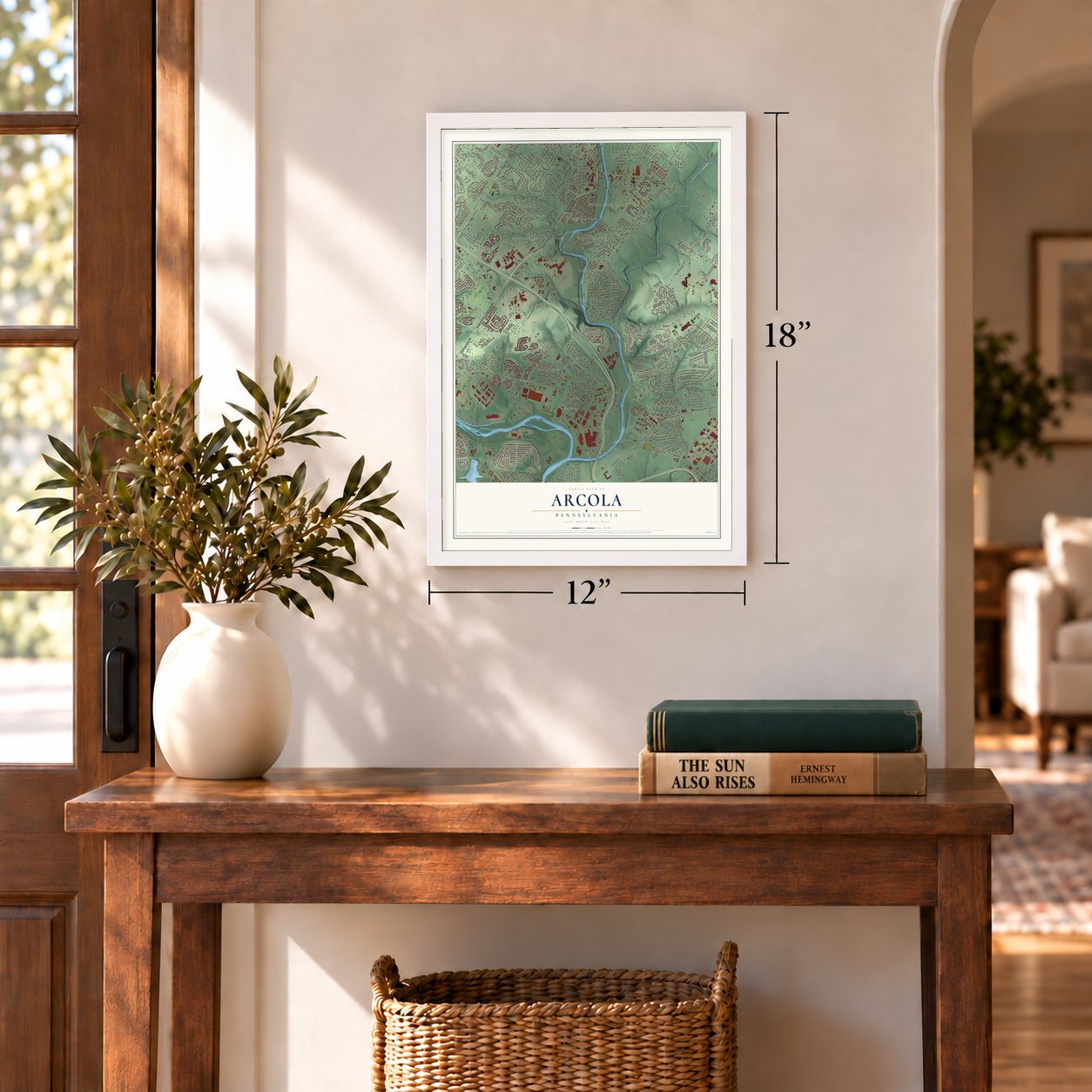
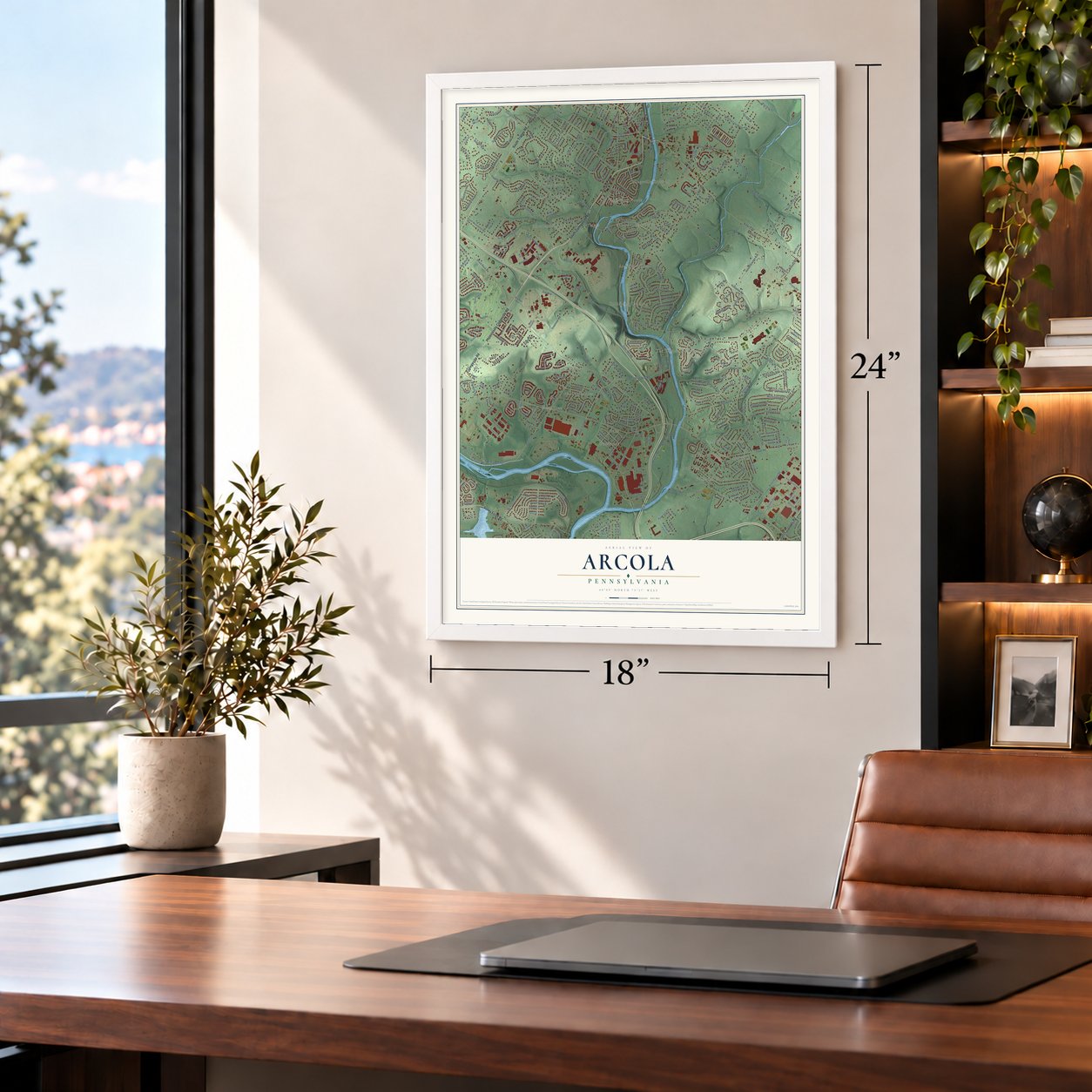
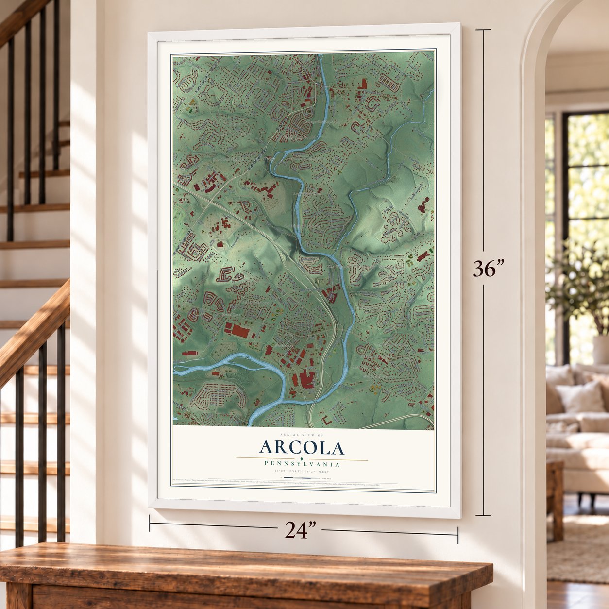
12" x 18" Archival Matte Print
A Map of Home. A Work of Art.
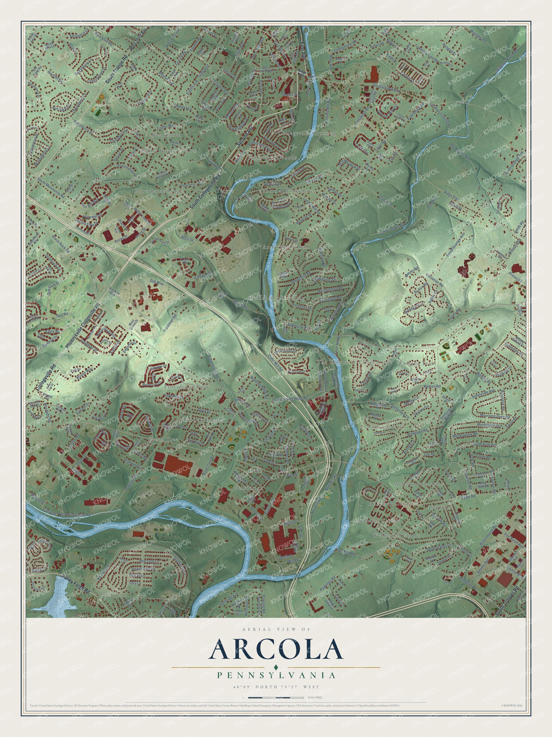
Explore Arcola, Pennsylvania from a whole new perspective. Created using aerial imagery and detailed geographic data, this map captures Arcola building by building, with labeled streets, familiar landmarks, and shaded topographical relief that highlights the natural contours of the landscape.
Combining modern data with the timeless character of a vintage atlas, this map is just as interesting up close as it is beautiful on the wall. Whether you grew up in Arcola, spent memorable years there, or call it home today, this unique map is a great way to celebrate a place that means something to you. Zoom in on the preview to look for your street, and then order a print to put your memories on the wall.
Three ways to hang it
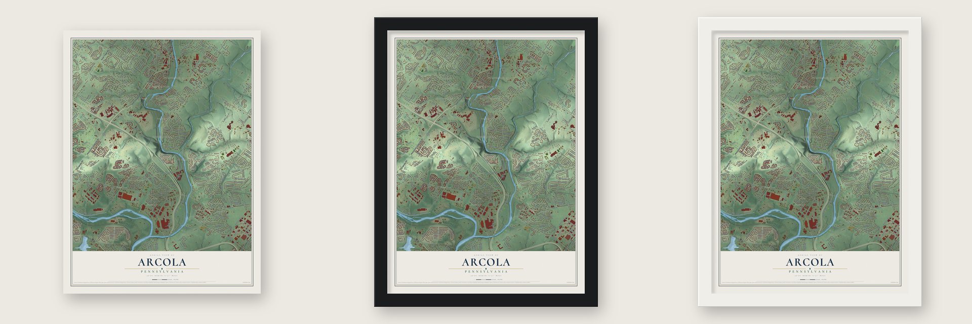
Unframed archival matte, a black wood frame or a white wood frame.
Up close
Geography Worth Displaying
This map was created using accurate cartographic data and authoritative geographic sources, including the U.S. Geological Survey and the Census Bureau. The map brings together terrain, waterways, roads, and building detail. The majority of the streets are labeled, houses are accurately depicted, and the topography is derived from government sources. Combining local data with carefully composed color and shading leads to this beautifully detailed Arcola artwork for your wall.
Rather than simply showing street outlines, we’ve included as many of the street names as we could reasonably fit on the map while keeping their names legible. Zoom in on the high resolution preview to see exactly what’s on the map. We truly set out to create a statement piece for anyone who loves Arcola. So whether it’s for you, or a gift for someone you love, we hope this map of Arcola brings back fond memories.
Read the story behind this map: Detailed Map of Arcola, Pennsylvania.

Find your street
Names on the Arcola map
Every name below is printed on this map. Look for your street, your school, the park where you played, or the pond down the road.
Places and landmarks24
- Anderson Park
- Black Rock Park
- Warlgya Tract
- Perkiomen
- Audubon Gardens
- Collegeville Crossing
- Arrowhead Knoll
- Providence View
- The Colony at Valley Forge
- Wetherills Corner
- Donny Brook Estates
- Coldspring Crossing
Show all 24 places
- Green Tree
- Providence Ridge
- Arbors at Providence
- Providence Oaks
- Audobon Gardens
- Pin Oak Estates
- Yerkes
- Perkiomen Woods
- Weatherlea
- Audubon
- Audubon Shrine
- Oaks
Streets and roads376
- South Collegeville Road
- Second Avenue
- Phoenixville Collgeville Road
- South Trappe Road
- Valley Forge Road
- Collegeville Road
- South Trooper Road
- First Avenue
- Hall Road
- Bluebird Drive
- Bechtel Road
- Ithan Lane
- Green Tree Road
- Upper Indian Head Road
- West Fifth Avenue
- Avon Avenue
- Canal Street
- Redtail Road
- Richard Way
- Golf Club Drive
- Eagleville Road
- Vincent Drive
- Thornhill Drive
- Walnut Street
- Springmill Lane
- Audubon Road
- Port Providence Road
- Drummers Lane
- Green Road
- Egypt Road
Show all 376 streets
- Arcola Road
- Black Rock Road
- Ridge Pike
- Pawlings Road
- South Mennonite Road
- Germantown Pike
- Level Road
- Hollow Road
- McAvoy Lane
- Morgan Lane
- Station Avenue
- Cider Mill Road
- Gsk Way
- Picket Post Lane
- Clayhor Avenue
- South Park Avenue
- Evansburg Road
- Visitation Road
- Longford Road
- Yerkes Road
- Goldfinch Circle
- Crosskeys Road
- Mill Road
- Rittenhouse Road
- Longacre Drive
- Fern Avenue
- Persimmon Drive
- Sunnyside Avenue
- Featherbed Lane
- Troutman Road
- Freeland Drive
- Eighth Avenue
- River Road
- West Drive
- Pinetown Road
- Ashenfelter Road
- Skippack Creek Road
- New Mill Road
- Newmill Road
- Adams Avenue
- North Grange Avenue
- Valley Vu
- Lantern Lane
- South Grange Avenue
- Monroe Boulevard
- Hi-Vue Road
- Mourning Dove Road
- Iron Hill Way
- Pechins Mill Road
- Park Avenue
- Barrington Road
- Thrush Lane
- Perkiomen Boulevard
- Worthington Road
- Coldsprings Drive
- Campus Drive
- Old Baptist Road
- Stoughton Road
- Mockingbird Lane
- Cedar Lane
- Red Coat Lane
- Greenes Way Circle
- Cottonwood Drive
- Chestnut Street
- Lower Lewis Road
- East Main Street
- Patriot Drive
- Apple Valley Lane
- Winthrop Road
- Township Line Road
- Locust Street
- Sloan Road
- Water Loop Drive
- Paperbirch Drive
- Prison Road
- Laurel Lane
- Schell Lane
- Highley Road
- Hudson Drive
- Pin Oak Drive
- Wilson Way
- Wayland Road
- Lattice Lane
- Gertrude Avenue
- Sixth Avenue
- Brenda Lane
- Chinaberry Lane
- Nancy Lane
- Tawnyberry Lane
- Boro Line Road
- Kaitlin Drive
- Minuteman Drive
- Shakespeare Drive
- Peters Way
- Fairhill Drive
- Condor Drive
- Leatherwood Drive
- Patriot Lane
- Winterberry Lane
- Hopewell Drive
- Landis Mill Road
- Redwing Lane
- Woodgate Lane
- Stine Drive
- North Drive
- Meadowlark Road
- East Drive
- Jode Road
- Crawford Road
- Buckwalter Road
- Pawling Road
- Hilltop Lane
- Winding Ridge Road
- Macdade Road
- Broad Street
- Gumbes Road
- Van Buren Avenue
- Constitution Drive
- Front Street
- Hanover Road
- School Street
- Runnymead Drive
- Still Meadow Drive
- West First Avenue
- Wilson Boulevard
- Maykut Avenue
- Hillview Drive
- Caroline Drive
- Ironwood Drive
- Sparrow Road
- Goldman Drive
- Elisabeth Lane
- Sugarberry Lane
- Summit Drive
- Oriole Lane
- Joshua Tree Drive
- Dana Drive
- Lee Road
- Vaux Lane
- Old Mill Road
- Central Avenue
- Page Lane
- Ringneck Road
- Reagan Drive
- Wetherill Road
- Biddle Lane
- Zvarick Road
- Trotter Way
- Raynham Road
- Greene Lane
- Birchleaf Drive
- Appledale Road
- Jasper Lane
- Lark Lane
- Eagle Road
- Tory Lane
- Thoms Drive
- Firethorn Drive
- Edgehill Drive
- South Drive
- Skyline Circle
- Reserve Drive
- Sumter Drive
- Brandon Circle
- Fell Drive
- Heritage Drive
- Henry Avenue
- Beth Drive
- Ferry Lane
- Knox Drive
- Pennco Road
- Monitor Drive
- Baker Street
- Smith Road
- Moyer Road
- Derr Drive
- Linnet Road
- Merlin Circle
- Plaza Drive
- Charles Street
- Hoy Circle
- Gratz Road
- Fox Road
- High Street
- West Third Avenue
- Main Street
- Culp Road
- Eden Boulevard
- Hopwood Road
- Stratford Avenue
- Montgomery Avenue
- Skyline Drive
- Spring Mill Lane
- Hunt Club Drive
- Marshwood Drive
- Taylor Way
- Wheat Sheaf Way
- Osprey Drive
- Pawlings Circle
- Gateshead Way
- Pin Oaks Drive
- Carmen Drive
- Dorchester Road
- Green Valley Drive
- Falcon Road
- Lower Indian Head Road
- Brower Avenue
- River Crest Drive
- Old Baptist Church Road
- Jefferson Avenue
- Woodland Avenue
- Amanda Lane
- Freedom Valley Drive
- Cressm Boulevard
- Sunset Avenue
- Water Fall Circle
- Larkspur Lane
- Eleventh Avenue
- Tyson Mill Road
- Colonial Avenue
- Lawrence Road
- Ashton Road
- South Lewis Road
- Woodsedge Road
- Cardinal Road
- Mary Bell Road
- Chapel View Lane
- Hawthorne Lane
- Hemlock Drive
- Old State Road
- Middle School Drive
- Springhouse Drive
- Sunnyside Woods
- Scarlet Oak Drive
- Cannon Hill Lane
- Argyle Lane
- Woods End Court
- East Third Avenue
- Sonnet Lane
- Longspur Road
- Old Cross Keys Road
- West Grove Drive
- East Circle Drive
- Catherine Road
- Brower Road
- Robin Lane
- Lincoln Street
- Lloyd Avenue
- Bonny Lane
- Forest Lane
- Borton Road
- Matlack Drive
- Guilford Circle
- Shelly Drive
- Larkin Lane
- Lenape Drive
- Theresa Street
- Seventh Avenue
- Denise Court
- Sterling Place
- Stellas Way
- Willow Avenue
- Doe Run Boulevard
- Blue Teel Circle
- Kim Road
- Kenney Lane
- Beverly Drive
- Schara Lane
- Owl Road
- Lisa Lane
- Groff Circle
- Bridle Lane
- Saylor Lane
- Stable Court
- Unity Way
- Elysia Lane
- Steinbright Drive
- Providence Circle
- Dorchester Way
- Shearwater Drive
- Nottingham Lane
- Ridgeview Drive
- Mill Grove Drive
- Shetland Way
- Shenandoah Drive
- Lisa Marie Lane
- Market Street
- Wayfield Drive
- Claymont Drive
- Green Briar Drive
- Glenwood Avenue
- Barklays Way
- Sharon Lane
- Hildebidle Drive
- Oaks School Drive
- Wetherill Lane
- Holstein Road
- Madison Avenue
- Brando Way
- Forge Hill Lane
- Eagle Stream Drive
- Condor Circle
- Anderson Road
- Osprey Way
- Skipview Lane
- Water Loop Lane
- Ramsgate Drive
- Camiel Lane
- Thayer Way
- Rock Dove Lane
- Logan Road
- Hodes Avenue
- Audubon Avenue
- Fifth Ward Road
- Edward Lane
- Doris Drive
- Redtail Court
- Musket Lane
- Clamer Avenue
- Orchard Lane
- East Fourth Avenue
- Perkiomen Avenue
- Casselberry Drive
- Regency Hills Drive
- Pinetree Drive
- Rivers Edge Drive
- Springwood Lane
- Greene Meadow Drive
- Sourwood Lane
- Faraway Farm Court
- Valley View Road
- Stoneham Road
- Oakland Avenue
- Cardinal Lane
- Bryce Way
- Olympic Road
- Kestral Circle
- Twilight Circle
- Bunting Circle
- Peregrine Circle
- Black Hawk Circle
- Blue Bird Circle
- Hickory Place
- Timothy Trail
- Willow Drive
- Oriole Court
Names are listed as they appear on the printed map. Zoom into the product photos to find them.
About Arcola, Pennsylvania
Arcola grew up as one of three new villages after the Perkiomen Railroad opened. Its stop was first known as Water-Tank, then as Doe Run Station. Later it took the name Arcola from the large mills of Wetherill and Co. In 1884 it was still a very small village.
Keep exploring Pennsylvania
Arcola is one of 3,725 Pennsylvania towns we've mapped. Every dot on the map is a print of its own.
The search covers every state, Pennsylvania first.
Near Arcola
Order 2 or more town maps and save 10%. Shown in the size and finish you picked above, so they hang as a set.
- Oaks 12" x 18" / Archival Matte Print $39.99
- Upper Providence 12" x 18" / Archival Matte Print $39.99
- Lower Providence 12" x 18" / Archival Matte Print $39.99
More maps nearby: Audubon, Collegeville, Mont Clare, Eagleville and Evansburg.
The art of mapping a place
How This Map Was Made
Real places. Remarkable detail. Discover the layers that turn geographic data into a map of home.

The view from above
Aerial imagery reveals the character of the land: woodland, open fields, and the patterns of a place.

The shape of the land
Elevation data brings hills, valleys, and subtle changes in the landscape into view.

The details of home
Roads, waterways, and building footprints come together to make the map feel unmistakably local.

Geography becomes art
Considered color, shading, and typography bring the layers together in a map made for your wall.


Process illustrated with Mendon, Massachusetts. Aerial imagery: USDA NAIP. Terrain: USGS 3D Elevation Program. Map details and finished artwork: KNOWOL.
The Details
About This Print
Choose an archival matte print, or a black or white Ayous wood frame. The archival matte print is unframed.
Select your size and finish above to see the matching product image and price.
Materials & Craftsmanship
A contemporary map with the character of a classic atlas, printed on archival matte paper. Optional frames are made from Ayous wood.
Your printed map does not include the watermark shown in the full-map preview.
Shipping & Delivery
Free shipping within the United States. Every print is made to order in the USA.
Buying a gift? Add a note in your cart and we'll include it. We never put prices in the package.
Prints ship within 2 to 3 business days. Allow 7 to 10 days total from ordering for delivery. Timing may vary during holidays or periods of high order volume.
Read our shipping policy.
Returns and damaged prints
Each print is made to order. Change-of-mind refunds are not available after production.
If your print arrives damaged, misprinted or incorrect, contact support@knowol.com within 30 days of receiving it. Include your order number, photos and a description of the issue.
Read our full refund and replacement policy. For questions about your order, email support@knowol.com.