


Search for another town


Free U.S. delivery 7 to 10 days after you order
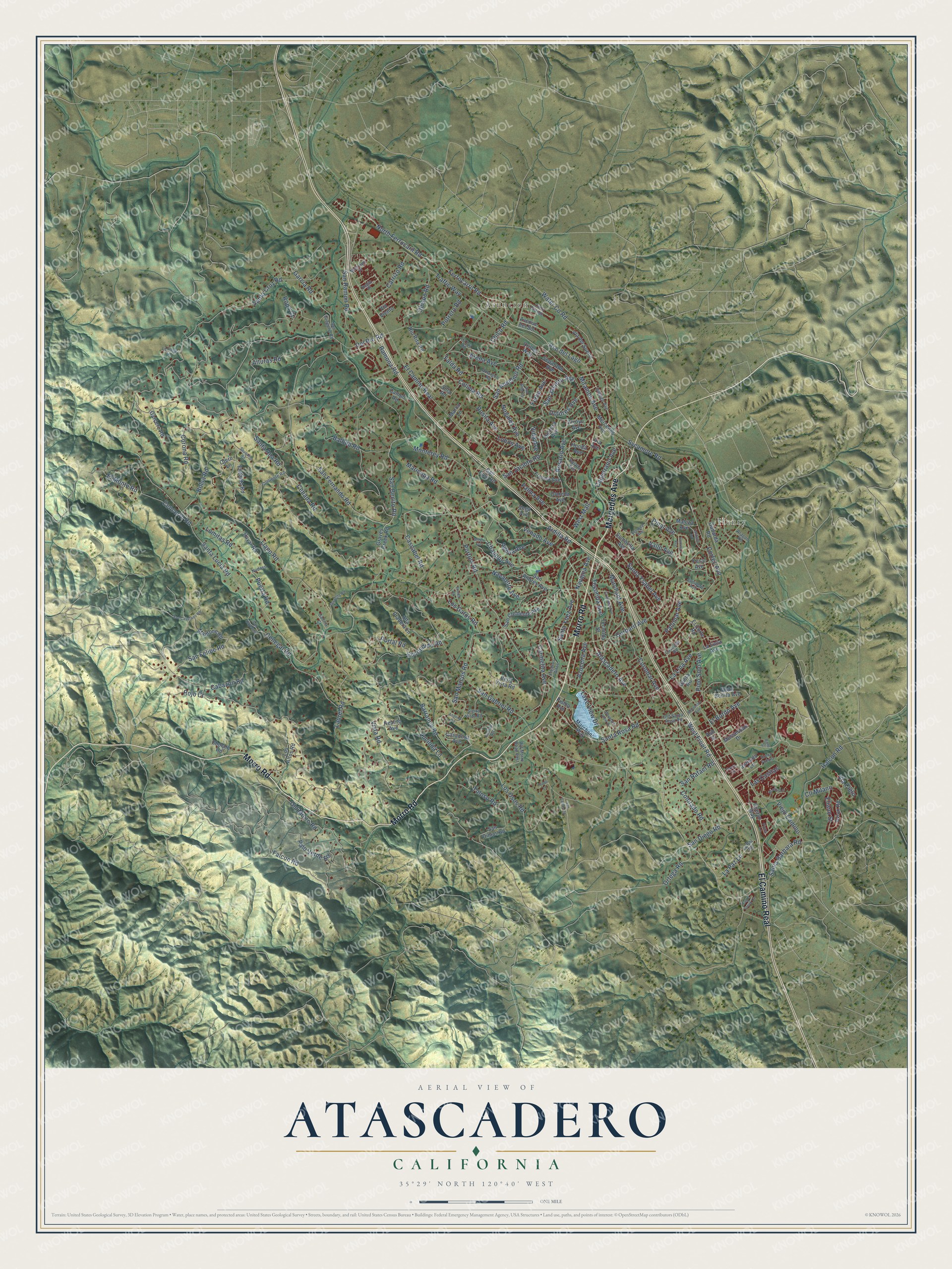
Atascadero, California Map Art
Building by building, with labeled streets and shaded relief.
12" x 18" Archival Matte Print
A Map of Home. A Work of Art.
Explore Atascadero, California from a whole new perspective. Created using aerial imagery and detailed geographic data, this map captures Atascadero building by building, with labeled streets, familiar landmarks, and shaded topographical relief that highlights the natural contours of the landscape.
Combining modern data with the timeless character of a vintage atlas, this map is just as interesting up close as it is beautiful on the wall. Whether you grew up in Atascadero, spent memorable years there, or call it home today, this unique map is a great way to celebrate a place that means something to you. Zoom in on the preview to look for your street, and then order a print to put your memories on the wall.
Three ways to hang it

Unframed archival matte, a black wood frame or a white wood frame.
Up close
Geography Worth Displaying
This map was created using accurate cartographic data and authoritative geographic sources, including the U.S. Geological Survey and the Census Bureau. The map brings together terrain, waterways, roads, and building detail. The majority of the streets are labeled, houses are accurately depicted, and the topography is derived from government sources. Combining local data with carefully composed color and shading leads to this beautifully detailed Atascadero artwork for your wall.
Rather than simply showing street outlines, we’ve included as many of the street names as we could reasonably fit on the map while keeping their names legible. Zoom in on the high resolution preview to see exactly what’s on the map. We truly set out to create a statement piece for anyone who loves Atascadero. So whether it’s for you, or a gift for someone you love, we hope this map of Atascadero brings back fond memories.
Read the story behind this map of Atascadero, California from 2026.

Find your street
Names on the Atascadero map
Every name below is printed on this map. Look for your street, your school, the park where you played, or the pond down the road.
Places and landmarks2
- Asuncion
- Henry
Streets and roads200
- Mercedes Avenue
- Morro Road
- El Camino Real
- Atascadero Avenue
- Ardilla Road
- North Ferrocaril Road
- Ferrocarril Road
- Pso del Lago
- Miramon Avenue
- Ortega Road
- Portola Road
- San Rafael Road
- San Diego Road
- San Marcos Road
- San Felipe Road
- Marchant Avenue
- Vida Avenue
- Santa Lucia Road
- Santa Ana Road
- San Gabriel Road
- Del Rio Road
- Traffic Way
- Santa Cruz Road
- Balboa Road
- Curbaril Avenue
- San Fernando Road
- Sycamore Road
- San Benito Road
- Carmelita Avenue
- Llano Road
Show all 200 streets
- Old Morro Road
- Monterey Road
- San Anselmo Road
- Santa Rosa Road
- San Jacinto Avenue
- San Jacinto Road
- San Ramon Road
- Ramona Road
- Santa Ynez Avenue
- Falcon Road
- Valle Avenue
- Los Osos Road
- Escondido Road
- Capistrano Avenue
- Cenegal Road
- Alturas Road
- Rosario Avenue
- Santa Barbara Road
- Halcon Road
- Lomitas Road
- Laurel Road
- Garcia Road
- Palomar Avenue
- Dolores Avenue
- Nogales Avenue
- Arena Avenue
- El Monte Road
- Palo Verde Road
- Corona Road
- Palma Avenue
- Aguila Avenue
- Santa Ysabel Avenue
- West Front Road
- Vista Road
- Navajoa Avenue
- Venado Avenue
- Portal Road
- Pinal Avenue
- Coromar Avenue
- Cascabel Road
- Water County Road
- Falda Road
- Viejo Camino
- Tecorida Avenue
- Cortez Avenue
- Maricopa Road
- Obispo Road
- Navarette Avenue
- La Lina Avenue
- Lake View Drive
- Colima Road
- Barranco Road
- El Bordo Avenue
- Chauplin Avenue
- Carrizo Road
- Bolsa Road
- Cencerro Road
- Colorado Road
- Los Gatos Road
- Cabazon Road
- Rosita Avenue
- La Paz Lane
- Puerta Road
- Toloso Road
- Lobos Avenue
- West Mall
- Azucena Avenue
- Eliano Street
- Cll Milano
- Cebada Road
- Chico Road
- Lucinda Lane
- Pino Solo Avenue
- Potrero Road
- Via Cielo
- Las Casitas
- Yerba Avenue
- Rojo Court
- Ropa Court
- Via Avenue
- Madrone Road
- Graves Creek Road
- San Andres Avenue
- Bella Vista Road
- Los Altos Road
- San Dimas Road
- Olmeda Avenue
- Alta Pradera Lane
- Casanova Avenue
- Tecorida Street
- Sombrilla Avenue
- La Linia Avenue
- Rayar Road
- Encanto Road
- Vega Avenue
- San Palo Road
- Realito Avenue
- Gabarda Road
- Dulzura Avenue
- San Clemente Avenue
- Via del Sueno
- Otero Lane
- Separado Avenue
- Avion Road
- Vista Bonita Avenue
- Marchant Way
- Fresno Avenue
- Maleza Avenue
- Honda Avenue
- El Corte Road
- Cuervo Way
- Campo Road
- Orillas Way
- Garcero Road
- Silla Road
- Musselman Drive
- Rio Rita Road
- Cholare Road
- Avenue del Sol
- Yesal Avenue
- Jornada Lane
- Arroyo Avenue
- Via Viento
- Pismo Avenue
- Marco Lane
- Gusta Road
- Ash Street
- San Gregorio Road
- Corriente Road
- Hidalgo Avenue
- Junipero Avenue
- Sierra Vista Road
- Old Morro Road East
- Cielo Grande
- La Paz Road
- La Luz Road
- Bajada Avenue
- Amargon Road
- Lenosa Lane
- Regio Place
- Cascada Road
- Old Santa Rosa Road
- Madrono Place
- Piedros Altos
- Gallina Court
- Nudoso
- Aragon Road
- Cristobal Avenue
- Bocina Lane
- Castano Avenue
- Mountain View Drive
- San Cayetano Road
- Buena Fortuna
- Tecolote Road
- Patria Circle
- San Cayetano
- San Ardo Road
- Escarpa Avenue
- Cortina Avenue
- Bane Street
- Flores Road
- Casitas Avenue
- Andrita Road
- Montecito Avenue
- San Carlos Road
- Sausalito Road
- Eagle Creek Court
- Piona Lane
- Atajo Avenue
- Prado Lane
Names are listed as they appear on the printed map. Zoom into the product photos to find them.
About Atascadero, California
Atascadero is a city of 29,773 people in San Luis Obispo County, set between the Santa Lucia Range on its western side and the Salinas River on its eastern side. Its Spanish name means bog or mire. In 1842 Governor Juan Alvarado gave Rancho Atascadero to Trifon Garcia, and the land later became part of J. H. Henry's ranch.
In 1913 the publisher Edward Gardner Lewis, who had already built University City, Missouri, bought the land for $37.50 an acre. He planned a farm colony and hired experts in farming, engineering and town planning. Crews laid out home lots, orchard tracts and a civic center, with water lines and roads. Buyers stayed in a tent camp in 1914, and settlers came in 1915 to plant pears, peaches, apples, apricots and plums. The colony became a city on July 2, 1979.
“The Atascadero's third owner, the Honorable J. H. Henry, was to transfer the title of the 40 square mile property to Mrs. E. G. Lewis, representing the Women's Republic.”
- City Hall, built 1914 to 1918Bliss & Faville designed the colony's headquarters with bricks made in town, shaped like a Greek cross around central rotundas. The colony's holding company went bankrupt in the 1920s, and the building later held schools, county offices and veterans' services. The 2003 San Simeon earthquake, magnitude 6.5, badly damaged it. After ten years closed, it reopened as City Hall in August 2013. It is California Historical Landmark No. 958 and joined the National Register in 1977.
- The Printery of 1915Walter D. Bliss designed the Printery for the Woman's Publishing Company, whose rotogravure presses printed the Illustrated Review, women's magazines and newspaper inserts. Men and women both worked there, and The Atascadero News began printing in the building in 1916. It joined the National Register in 2004. Left empty after the 2003 earthquake, it was bought in 2017 by a nonprofit foundation formed in 2015 to restore it.
- A garden from a World's FairLewis modeled the Sunken Gardens on the Grand Basin of the 1904 St. Louis World's Fair. The park has a central fountain and Wrestling Bacchantes, a sculpture Lewis bought for his colony.
- Colony Days since 1973The town first held Colony Days in 1973 and added a parade in 1974, with floats from local groups. The Atascadero Historical Society keeps the Colony House Museum in a colony home from 1919.
Keep exploring California
Atascadero is one of 1,990 California towns we've mapped. Every dot on the map is a print of its own.
The search covers every state, California first.
Near Atascadero
Order 2 or more town maps and save 10%. Shown in the size and finish you picked above, so they hang as a set.
- Templeton 12" x 18" / Archival Matte Print $39.99
- Garden Farms 12" x 18" / Archival Matte Print $39.99
- Santa Margarita 12" x 18" / Archival Matte Print $39.99


More maps nearby: Creston, Paso Robles, Cayucos, California Polytechnic State University and Morro Bay.
The art of mapping a place
How This Map Was Made
Real places. Remarkable detail. Discover the layers that turn geographic data into a map of home.

The view from above
Aerial imagery reveals the character of the land: woodland, open fields, and the patterns of a place.

The shape of the land
Elevation data brings hills, valleys, and subtle changes in the landscape into view.

The details of home
Roads, waterways, and building footprints come together to make the map feel unmistakably local.

Geography becomes art
Considered color, shading, and typography bring the layers together in a map made for your wall.


Process illustrated with Mendon, Massachusetts. Aerial imagery: USDA NAIP. Terrain: USGS 3D Elevation Program. Map details and finished artwork: KNOWOL.
The Details
About This Print
Choose an archival matte print, or a black or white Ayous wood frame. The archival matte print is unframed.
Select your size and finish above to see the matching product image and price.
Materials & Craftsmanship
A contemporary map with the character of a classic atlas, printed on archival matte paper. Optional frames are made from Ayous wood.
Your printed map does not include the watermark shown in the full-map preview.
Shipping & Delivery
Free shipping within the United States. Every print is made to order in the USA.
Buying a gift? Add a note in your cart and we'll include it. We never put prices in the package.
Prints ship within 2 to 3 business days. Allow 7 to 10 days total from ordering for delivery. Timing may vary during holidays or periods of high order volume.
Read our shipping policy.
Returns and damaged prints
Each print is made to order. Change-of-mind refunds are not available after production.
If your print arrives damaged, misprinted or incorrect, contact support@knowol.com within 30 days of receiving it. Include your order number, photos and a description of the issue.
Read our full refund and replacement policy. For questions about your order, email support@knowol.com.