


Search for another town


Free U.S. delivery 7 to 10 days after you order
Barnstead, New Hampshire Map Art
Building by building, with labeled streets and shaded relief.
12" x 18" Archival Matte Print
A Map of Home. A Work of Art.
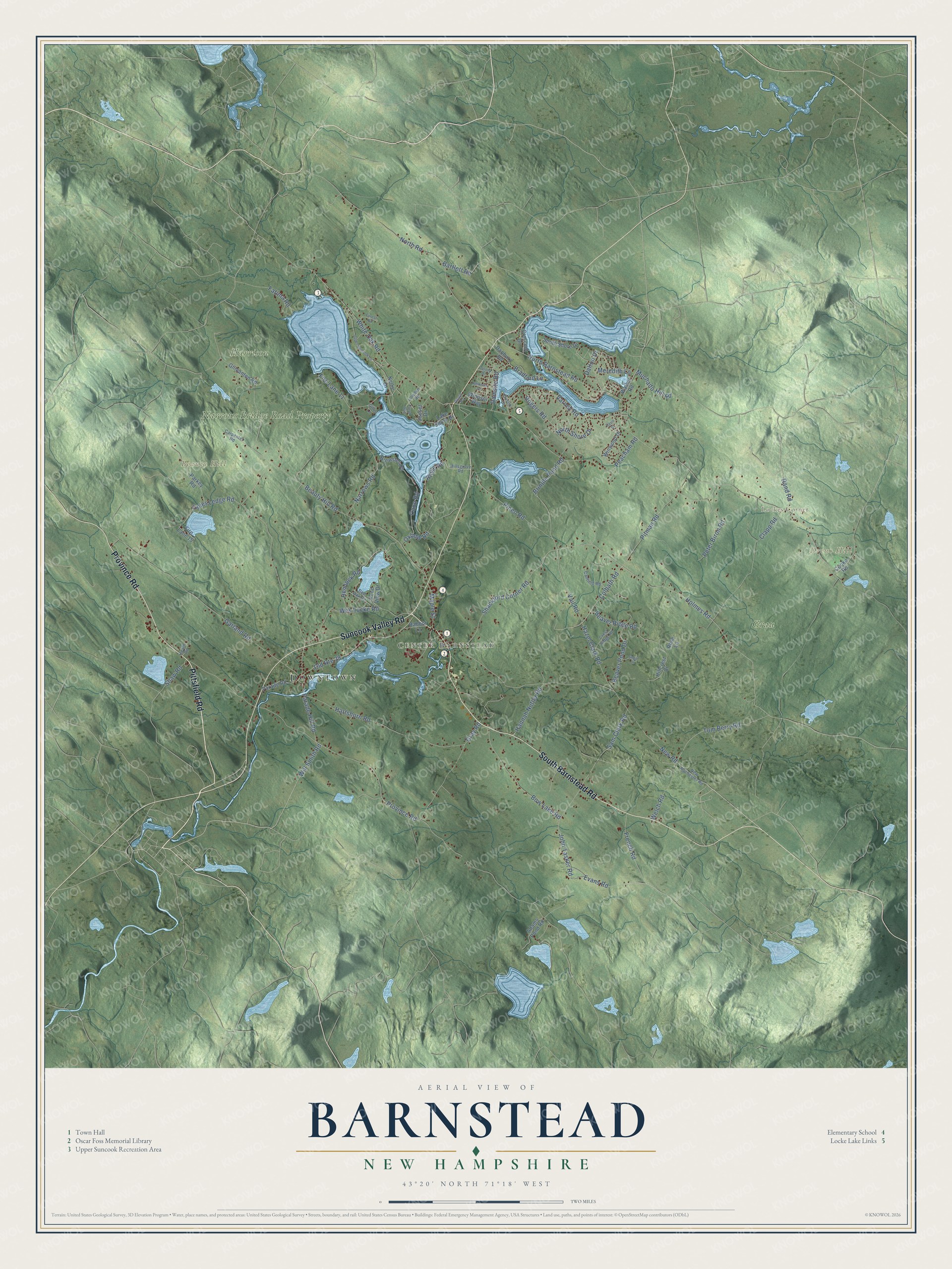
Explore Barnstead, New Hampshire from a whole new perspective. Created using aerial imagery and detailed geographic data, this map captures Barnstead building by building, with labeled streets, familiar landmarks, and shaded topographical relief that highlights the natural contours of the landscape.
Combining modern data with the timeless character of a vintage atlas, this map is just as interesting up close as it is beautiful on the wall. Whether you grew up in Barnstead, spent memorable years there, or call it home today, this unique map is a great way to celebrate a place that means something to you. Zoom in on the preview to look for your street, and then order a print to put your memories on the wall.
Three ways to hang it

Unframed archival matte, a black wood frame or a white wood frame.
Up close
Geography Worth Displaying
This map was created using accurate cartographic data and authoritative geographic sources, including the U.S. Geological Survey (USGS) and FEMA. The map brings together terrain, waterways, roads, and building detail. The majority of the streets are labeled, houses are accurately depicted, and the topography is derived from government sources. Combining local data with carefully composed color and shading leads to this beautifully detailed Barnstead artwork for your wall.
Rather than simply showing street outlines, we’ve included as many of the street names as we could reasonably fit on the map while keeping their names legible. Zoom in on the high resolution preview to see exactly what’s on the map. We truly set out to create a statement piece for anyone who loves Barnstead. So whether it’s for you, or a gift for someone you love, we hope this map of Barnstead brings back fond memories.
Explore the full map of Barnstead, New Hampshire and read about the local places it shows.

Find your street
Names on the Barnstead map
Every name below is printed on this map. Look for your street, your school, the park where you played, or the pond down the road.
Places and landmarks8
- Downtown
- Center Barnstead
- Lockes Corner
- Beauty Hill
- Drews Hill
- Harrison
- Narrows Bridge Road Property
- Grau
Streets and roads95
- Pittsfield Road
- South Barnstead Road
- Suncook Valley Road
- Province Road
- Colbath Road
- Hannah Nutter Road
- Holmes Road
- Tom Berry Road
- White Oak Road
- Shackford Corner Road
- Sam Clark Road
- Vail Road
- Maple Street
- North Barnstead Road
- Beauty Hill Road
- New Road
- Garland Road
- North Road
- Peacham Road
- Narrows Road
- Old Route 28
- Hartshorn Road
- John Tasker Road
- Varney Road
- Pitman Road
- Clapp Road
- Wes Locke Road
- Bow Lake Road
- Gray Road
- Pineo Road
Show all 95 streets
- Brindle Pond Road
- Oxbow Road
- Beaver Ridge Road
- Hemlock Road
- Coles Ledge Road
- Peter Biron Road
- Ridge Road
- Hazel Clark Road
- Beaver Pond Drive
- Cann Road
- Parade Hill Road
- Welch Road
- North Shore Drive
- Evans Road
- French Road
- Damsite Road
- Rogers Road
- Fire Lane 11
- Muchado Hill Road
- Will Smith Road
- Bartlett Road
- Meredith Lane
- Bradford Lane
- Rand Road
- Dalton Drive
- Fatima Road
- Shaw Road
- Nellie Lane
- Fire Lane 15
- Windsor Way
- Parade Road
- Gilmanton Road
- Parkey Road
- South Shore Drive
- Winwood Drive
- Cooke Road
- Hillcrest Court
- Adams Pond Road
- Crescent Drive
- Lake Shore Drive
- Brewster Road
- Walker Road
- Sunset Drive
- Pond View Drive
- Danbury Road
- Rabbot Lane
- Rose Lane
- New Rochester Road
- Canfield Road
- Red Oak Road
- Crest Ridge Road
- Carpenter Road
- Hillsgrove Road
- Lowden Road
- Heath Road
- Dustin Drive
- Gillis Lane
- Upper Suncook Lane
- Floyd Way
- Forest Road
- Sugar Lane
- Colony Drive
- Ripple Road
- Amherst Drive
- Davis Drive
Names are listed as they appear on the printed map. Zoom into the product photos to find them.
About Barnstead, New Hampshire
Barnstead is a town of 4,915 people in Belknap County, drained by the Suncook River. The Reverend Joseph Adams and his fellow grantees received the land on May 20, 1727, from Lieutenant Governor John Wentworth, but no one settled here for nearly four decades. When families finally came in 1765, many arrived from Barnstable, Massachusetts, and Hempstead, New York, so the new town's name blends those two places. Governor John Wentworth made Barnstead an incorporated town two years after settlement began.
The land isn't mountainous, but its broad swells made good pasture, and farmers found the soil easy to work. In 1830 the town had 2,047 people and about 2,500 sheep. Water from the Suncook River and the brooks feeding it turned the mills, and by 1859 Barnstead had seven sawmills, four shingle mills and four clapboard mills, along with a woolen cloth factory and two tanneries. It turned out so much lumber that it sold the surplus to neighboring towns, and by 1874 the Concord and Rochester Railroad served Barnstead.
- A library from four villagesBarnstead voted for a public library in 1892, but for years its books sat in homes and stores, once divided among the four villages. In 1906 they came together in one room of a Center Barnstead house. After the businessman Oscar Foss died in 1913, his widow Sarah gave the town a brick library in his memory, designed by the William M. Butterfield Company of Manchester and dedicated in 1917. The Oscar Foss Memorial Library is on the National Register.
- Town offices among the booksFor decades the town offices shared the Foss library building with the books. They moved out in 1979, and their side of the building became a children's reading room. A large addition went onto the back of the library in 2000.
- Twin lakes on the SuncookAt 402 acres and more than 40 feet deep, Upper Suncook Lake is the larger of the pair. Lower Suncook Lake spans 295 acres and has three islands. A road bridge crosses the 1,000-foot channel that joins them, and a single dam where the lower lake drains controls the level of both.
- Locke Lake and Lockes CornerLocke Lake, 149 acres, was created in the middle of the 20th century together with the homes around its shore, which started going up in the 1960s. Its water flows out through Webster Stream to the Suncook River. Near Lockes Corner on the northern border, the land rises to 1,190 feet, the highest ground in Barnstead.
Keep exploring New Hampshire
Barnstead is one of 279 New Hampshire towns we've mapped. Every dot on the map is a print of its own.
The search covers every state, New Hampshire first.
Near Barnstead
Order 2 or more town maps and save 10%. Shown in the size and finish you picked above, so they hang as a set.
- Pittsfield 12" x 18" / Archival Matte Print $39.99
- Strafford 12" x 18" / Archival Matte Print $39.99
- Gilmanton 12" x 18" / Archival Matte Print $39.99


More maps nearby: New Durham, Chichester, Northwood, Alton and Farmington.
The art of mapping a place
How This Map Was Made
Real places. Remarkable detail. Discover the layers that turn geographic data into a map of home.

The view from above
Aerial imagery reveals the character of the land: woodland, open fields, and the patterns of a place.

The shape of the land
Elevation data brings hills, valleys, and subtle changes in the landscape into view.

The details of home
Roads, waterways, and building footprints come together to make the map feel unmistakably local.

Geography becomes art
Considered color, shading, and typography bring the layers together in a map made for your wall.


Process illustrated with Mendon, Massachusetts. Aerial imagery: USDA NAIP. Terrain: USGS 3D Elevation Program. Map details and finished artwork: KNOWOL.
The Details
About This Print
Choose an archival matte print, or a black or white Ayous wood frame. The archival matte print is unframed.
Select your size and finish above to see the matching product image and price.
Materials & Craftsmanship
A contemporary map with the character of a classic atlas, printed on archival matte paper. Optional frames are made from Ayous wood.
Your printed map does not include the watermark shown in the full-map preview.
Shipping & Delivery
Free shipping within the United States. Every print is made to order in the USA.
Buying a gift? Add a note in your cart and we'll include it. We never put prices in the package.
Prints ship within 2 to 3 business days. Allow 7 to 10 days total from ordering for delivery. Timing may vary during holidays or periods of high order volume.
Read our shipping policy.
Returns and damaged prints
Each print is made to order. Change-of-mind refunds are not available after production.
If your print arrives damaged, misprinted or incorrect, contact support@knowol.com within 30 days of receiving it. Include your order number, photos and a description of the issue.
Read our full refund and replacement policy. For questions about your order, email support@knowol.com.