
Search for another town


Free U.S. delivery 7 to 10 days after you order
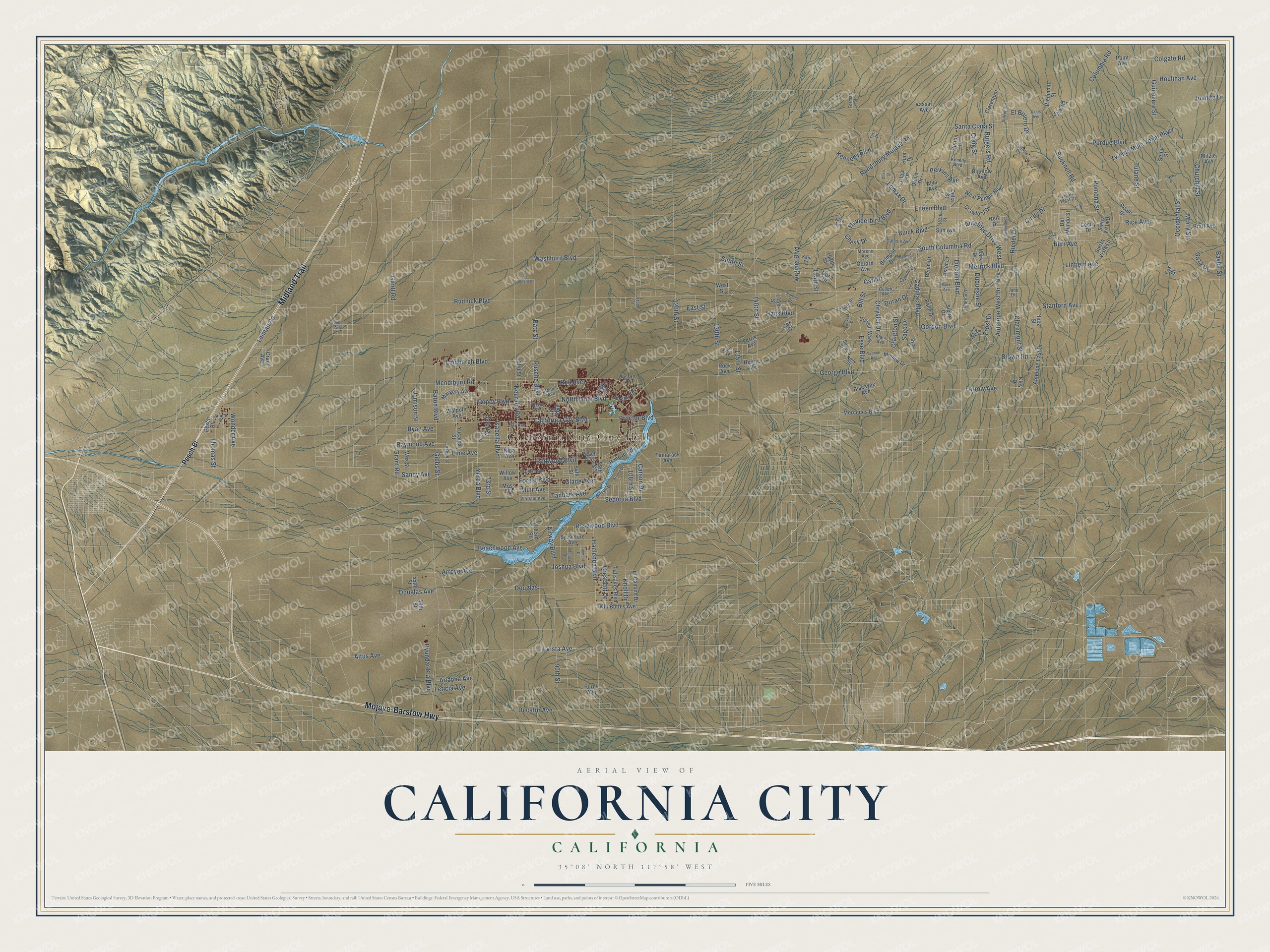
California City, California Map Art
Building by building, with labeled streets and shaded relief.
12" x 18" Archival Matte Print
A Map of Home. A Work of Art.
Explore California City, California from a whole new perspective. Created using aerial imagery and detailed geographic data, this map captures California City building by building, with labeled streets, familiar landmarks, and shaded topographical relief that highlights the natural contours of the landscape.
Combining modern data with the timeless character of a vintage atlas, this map is just as interesting up close as it is beautiful on the wall. Whether you grew up in California City, spent memorable years there, or call it home today, this unique map is a great way to celebrate a place that means something to you. Zoom in on the preview to look for your street, and then order a print to put your memories on the wall.
Three ways to hang it

Unframed archival matte, a black wood frame or a white wood frame.
Up close
Geography Worth Displaying
This map was created using accurate cartographic data and authoritative geographic sources, including the U.S. Geological Survey and the Census Bureau. The map brings together terrain, waterways, roads, and building detail. The majority of the streets are labeled, houses are accurately depicted, and the topography is derived from government sources. Combining local data with carefully composed color and shading leads to this beautifully detailed California City artwork for your wall.
Rather than simply showing street outlines, we’ve included as many of the street names as we could reasonably fit on the map while keeping their names legible. Zoom in on the high resolution preview to see exactly what’s on the map. We truly set out to create a statement piece for anyone who loves California City. So whether it’s for you, or a gift for someone you love, we hope this map of California City brings back fond memories.
Read the story behind this map of California City, California from 2026.

Find your street
Names on the California City map
Every name below is printed on this map. Look for your street, your school, the park where you played, or the pond down the road.
Places and landmarks1
- California City City Hall
Streets and roads241
- Mojave-Barstow Highway
- Midland Trail
- Neuralia Road
- Forest Boulevard
- Esse Boulevard
- Washburn Boulevard
- Proctor Boulevard
- Rudnick Boulevard
- Douglas
- Burr Avenue
- California City Boulevard
- Raymond Avenue
- Tanbark Avenue
- Twenty Mule Team Parkway
- Randsburg Mojave Road
- Bucknell Road
- Gordon Boulevard
- South Columbia Road
- 90th Street
- Lindbergh Boulevard
- Brown Road
- Lincoln Boulevard
- Rutgers Road
- Baylor Street
- George Boulevard
- Rosewood Boulevard
- Redwood Boulevard
- Chrysler Drive
- Hacienda Boulevard
- Kennedy Boulevard
Show all 241 streets
- Occidental Street
- Rice Avenue
- Mendiburu Road
- Yerba Boulevard
- Cadillac Boulevard
- Tulane Street
- Sequoia Boulevard
- Lime Avenue
- Churchill Street
- Leiman Road
- Stanford Avenue
- 140th Street
- Hans Boulevard
- Arroyo Avenue
- Gantt Road
- Purdue Boulevard
- La Vista Avenue
- Decatur Avenue
- Poppy Boulevard
- Duquesne Street
- Columbia Road
- Claremont Street
- Santa Clara Street
- Merrick Boulevard
- Jamison Street
- 130th Street
- Beachwood Avenue
- Isabella Boulevard
- Joshua Boulevard
- Colgate Road
- Airway Boulevard
- North Loop Boulevard
- Eileen Boulevard
- Thomas Street
- Sandy Avenue
- Houlihan Avenue
- Virginia Boulevard
- Hyundai-Kia Boulevard
- Douglas Avenue
- Gibbs Street
- Rea Avenue
- Guinevere Street
- Antelope Drive West
- Glade Avenue
- Thunderbird Boulevard
- Baron Boulevard
- Buick Boulevard
- Perkins Avenue
- Antelope West Drive
- Muir Avenue
- Cindy Drive
- Wonder Avenue
- Batz Street
- Sage Drive
- 120th Street
- Pomona Street
- Morry Street
- Crescent Drive
- Bill Street
- Doran Drive
- Grant Road
- Farrow Avenue
- Frost Drive
- 73rd Street
- Chevy Drive
- 155th Street
- Riedel Drive
- 108th Street
- El Bolero Drive
- Knoll Drive
- Rusche Boulevard
- Carl Drive
- Ryan Avenue
- Linfield Avenue
- Craigton Street
- Craig Street
- Leticia Avenue
- Arizona Avenue
- East Street
- Altus Avenue
- Gaza Drive
- South Street
- Carson Drive
- Lomax Drive
- 135th Street
- Juanita Drive
- 72nd Street
- Pesch Bl
- Mercedes Boulevard
- Twin Buttes Avenue
- Peach Avenue
- Walpole Avenue
- Tamarack Avenue
- Margery Avenue
- Moss Avenue
- 83rd Street
- Nipa Avenue
- 94th Street
- Yucaipa Street
- 89th Street
- Antelope East Drive
- Sycamore Avenue
- Willow Avenue
- Sierra Vista Drive
- 81st Street
- Hanover Drive
- Wes Street
- Belon Drive
- Consul Way
- 99th Street
- West Pebble Boulevard
- Sierra Vista Lane
- Hutton Drive
- Palisades Boulevard
- Aster Drive
- Vassar Avenue
- Strum Drive
- Crawford Drive
- 55th Street
- El Camino Drive
- 145th Street
- Mark Drive
- Gerard Avenue
- Point Avenue
- Piedmont Street
- Cecily Drive
- Jeremy Drive
- Bratt Avenue
- Palm Drive
- Biscayne Avenue
- Mitzie Avenue
- Sioux Drive
- Claremont
- Claar Drive
- Senia Street
- Bigelow Avenue
- Minlow Drive
- Otelia Drive
- Hunt Drive
- Belmont Drive
- Del Mundo Street
- 158th Street
- Ferris Avenue
- Dean Drive
- Kley Drive
- Neff Drive
- Adler Drive
- Henry Avenue
- Craig Avenue
- Sun Avenue
- Tag Drive
- Alva Avenue
- Purdy Avenue
- Delia Street
- 56th Street
- West Street
- Rock Avenue
- Poole Drive
- Cox Drive
- Inez Street
- Fox Court
- Forman Street
- Lois Drive
- Bay Avenue
- Verdant Avenue
- Wilson Drive
- Cullen Avenue
- Kenedy Boulevard
- Lipari West Drive
- Bymar Drive
- Galaxie Avenue
- Orlando Drive
- Klara Avenue
- Nelson Drive
- Janice Street
- Martin
- Marion Drive
- Surlin Street
- Joseph Street
- Stanhill Avenue
- Nelly Drive
- Lucile Drive
- Aristotle Drive
- Jack Avenue
- Moreno Avenue
- Jane Drive
- 187th Street
- Kent Drive
- Juan Drive
- Belle Street
- Tara Place
- Chati Street
- Quezon Avenue
- Viburnum Avenue
- Mc Donald Drive
- Arnold Drive
- Berendo Drive
- 71st Street
- Longworthy Street
- Mace Avenue
- Lookout Drive
- Mojave Drive
- Fremont Drive
- Yvonne Avenue
- Danis Avenue
- Bridle Avenue
- Ronald Drive
- Rachel Drive
- Sease Street
- 110th Street
- Ski Lane
Names are listed as they appear on the printed map. Zoom into the product photos to find them.
About California City, California
California City is a city of 14,973 people in Kern County, at the north end of the Antelope Valley. In 1958 developers bought 82,000 acres of the western Mojave Desert. They sold it as a northern answer to Los Angeles, which they said could not absorb the population boom after the war. Nat Mendelsohn, a sociology professor who led the California City Development Company, had Smith and Williams and the architect Garrett Eckbo draw up a master plan for 400,000 residents.
A post office opened in 1960. The city incorporated in 1965 with 817 residents and 232 homes, even though 5,900 people owned land there. Growth fell far short of the plan, and by 1969 the population stood near 1,300. The Federal Trade Commission ordered the sales company to stop its misleading ads. In 1977 a $4 million settlement, the biggest the FTC had ever reached, returned part of their money to more than 14,000 landowners, and the company had to spend $16 million on the roads and services it had long promised.
“a particularly stark study of government failure.”
- Garcés at Castle Butte, 1776Padre Francisco Garcés, a Franciscan missionary, made camp at Castle Butte, inside today's city, while traveling with Juan Bautista de Anza in 1776. Near the end of the 19th century, twenty-mule teams carried borax through the area. They hauled it from the Harmony Borax Works mines to the railhead at Mojave.
- A gunnery range until 1959From August 1944 until January 1959, pilots used Mojave Gunnery Range "C" here for bombing and strafing practice. Then the range became California City land. Army surveys that began in 1999 turned up practice bombs, rockets and ammunition. The most dangerous finds were two 100-pound general purpose bombs.
- Third largest in CaliforniaThe city covers 203.63 square miles. Only San Diego and Los Angeles have more land among California's cities. No other city in the state is as large without being a county seat. Much of that ground is still a grid of paved streets with no houses on them.
- Kern County's cannabis firstKern County's first city to permit commercial cannabis farms was California City, which allowed them in June 2016. Its leaders hoped the farms would bring in more than $10 million a year in taxes. Through the first three months of 2023, though, the city had taken in only around $98,000.
Keep exploring California
California City is one of 1,990 California towns we've mapped. Every dot on the map is a print of its own.
The search covers every state, California first.
Near California City
Order 2 or more town maps and save 10%. Shown in the size and finish you picked above, so they hang as a set.
- North Edwards 12" x 18" / Archival Matte Print $39.99
- Boron 12" x 18" / Archival Matte Print $39.99
- Edwards AFB 12" x 18" / Archival Matte Print $39.99


More maps nearby: Randsburg, Johannesburg, Mojave, Rosamond and Mountain Meadows.
The art of mapping a place
How This Map Was Made
Real places. Remarkable detail. Discover the layers that turn geographic data into a map of home.

The view from above
Aerial imagery reveals the character of the land: woodland, open fields, and the patterns of a place.

The shape of the land
Elevation data brings hills, valleys, and subtle changes in the landscape into view.

The details of home
Roads, waterways, and building footprints come together to make the map feel unmistakably local.

Geography becomes art
Considered color, shading, and typography bring the layers together in a map made for your wall.


Process illustrated with Mendon, Massachusetts. Aerial imagery: USDA NAIP. Terrain: USGS 3D Elevation Program. Map details and finished artwork: KNOWOL.
The Details
About This Print
Choose an archival matte print, or a black or white Ayous wood frame. The archival matte print is unframed.
Select your size and finish above to see the matching product image and price.
Materials & Craftsmanship
A contemporary map with the character of a classic atlas, printed on archival matte paper. Optional frames are made from Ayous wood.
Your printed map does not include the watermark shown in the full-map preview.
Shipping & Delivery
Free shipping within the United States. Every print is made to order in the USA.
Buying a gift? Add a note in your cart and we'll include it. We never put prices in the package.
Prints ship within 2 to 3 business days. Allow 7 to 10 days total from ordering for delivery. Timing may vary during holidays or periods of high order volume.
Read our shipping policy.
Returns and damaged prints
Each print is made to order. Change-of-mind refunds are not available after production.
If your print arrives damaged, misprinted or incorrect, contact support@knowol.com within 30 days of receiving it. Include your order number, photos and a description of the issue.
Read our full refund and replacement policy. For questions about your order, email support@knowol.com.