
Search for another town


Free U.S. delivery 7 to 10 days after you order
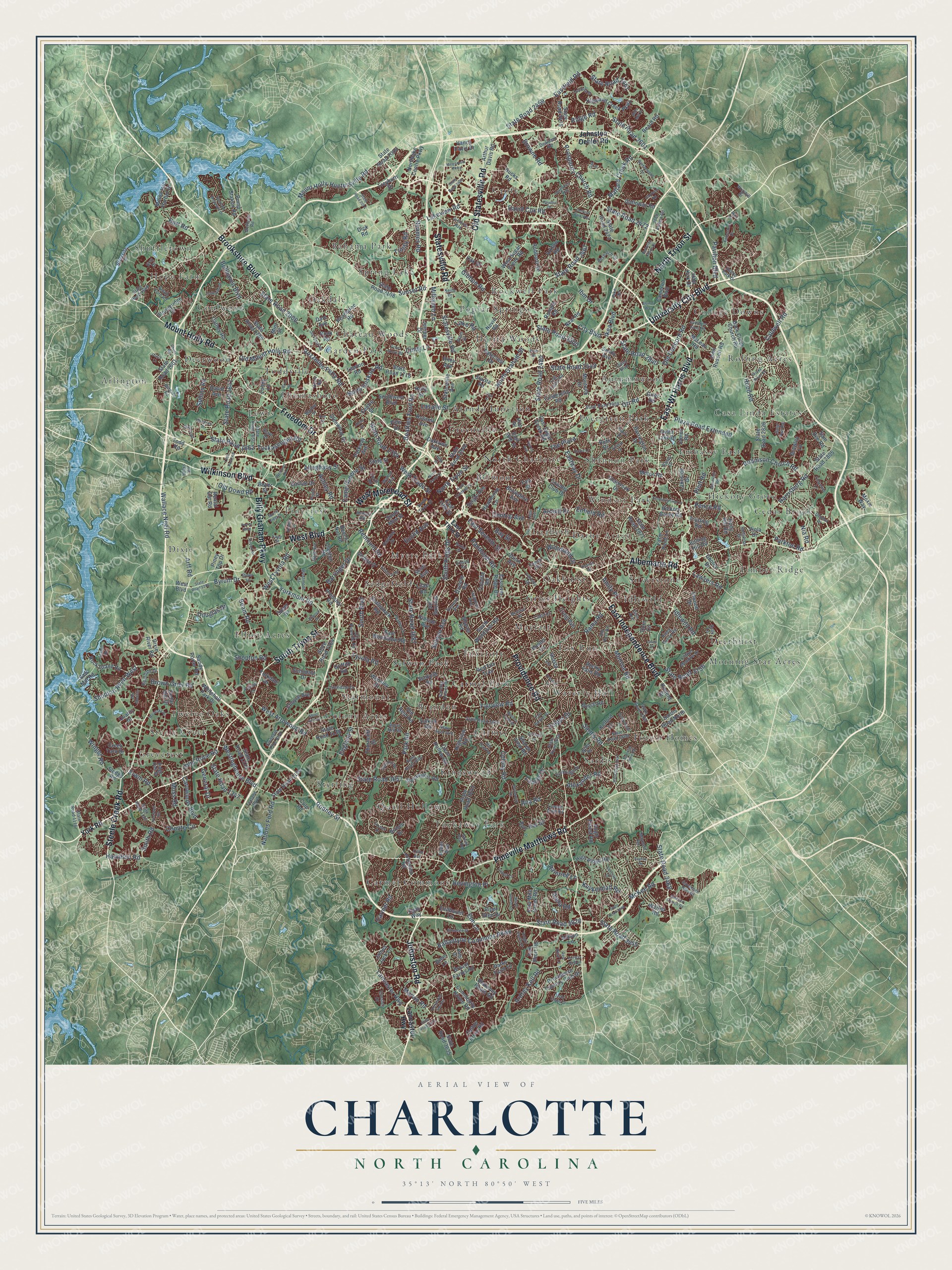
Charlotte, North Carolina Map Art
Building by building, with labeled streets and shaded relief.
12" x 18" Archival Matte Print
A Map of Home. A Work of Art.
Explore Charlotte, North Carolina from a whole new perspective. Created using aerial imagery and detailed geographic data, this map captures Charlotte building by building, with labeled streets, familiar landmarks, and shaded topographical relief that highlights the natural contours of the landscape.
Combining modern data with the timeless character of a vintage atlas, this map is just as interesting up close as it is beautiful on the wall. Whether you grew up in Charlotte, spent memorable years there, or call it home today, this unique map is a great way to celebrate a place that means something to you. Zoom in on the preview to look for your street, and then order a print to put your memories on the wall.
Three ways to hang it

Unframed archival matte, a black wood frame or a white wood frame.
Up close
Geography Worth Displaying
This map was created using accurate cartographic data and authoritative geographic sources, including the U.S. Geological Survey and the Census Bureau. The map brings together terrain, waterways, roads, and building detail. The majority of the streets are labeled, houses are accurately depicted, and the topography is derived from government sources. Combining local data with carefully composed color and shading leads to this beautifully detailed Charlotte artwork for your wall.
Rather than simply showing street outlines, we’ve included as many of the street names as we could reasonably fit on the map while keeping their names legible. Zoom in on the high resolution preview to see exactly what’s on the map. We truly set out to create a statement piece for anyone who loves Charlotte. So whether it’s for you, or a gift for someone you love, we hope this map of Charlotte brings back fond memories.
Read the story behind this map of Charlotte, North Carolina from 2026.

Find your street
Names on the Charlotte map
Every name below is printed on this map. Look for your street, your school, the park where you played, or the pond down the road.
Places and landmarks65
- Greycrest
- Rolling Acres
- Dixie
- Bahama Park
- Timber Ridge
- Hope Farm
- Forest Homes
- Carmel Commons
- Selwyn Park
- Evergreen Park
- Colony Acres
- Chateau Woods
Show all 65 places
- Idlewild
- Croft
- Atando Junction
- Pinecrest
- Lewis
- Cedar Brook
- Mayfair
- Sardis
- Twelve Oaks
- Kingswood
- Windsor Park
- Shuffletown
- Elliot Acres
- Quail Hollow
- Rockwell Park
- Thomasboro
- Fox Run
- Belmont
- Arlington
- Derita Woods
- Hickory Grove
- Sterling
- Casa Linda Estates
- Silverstone
- Grier Heights
- Morning Star Acres
- Embassy East
- Coulwood
- Sedgefield
- Brandon
- Carmel
- Waverly Hall
- Garden Park
- Darby Acres
- Carmel Park
- Elizabeth
- Steele Creek
- College Downs
- Deerwood
- Autumnwood
- Myers Park
- Toddville
- Shannon Park
- Tuckaway Park
- Poplar Springs
- Oakhurst
- Foxcroft
- Oakdale
- Starmount
- Spring Lake
- Greenville
- Deerhurst
- North Charlotte
Streets and roads478
- South Tryon Street
- East Wt Harris Boulevard
- Providence Road
- Brookshire Boulevard
- North Tryon Street
- Steele Creek Road
- Pineville Matthews Road
- East Independence Boulevard
- University City Boulevard
- Johnston Road
- Wilkinson Boulevard
- Freedom Drive
- Mount Holly Road
- Albemarle Road
- Billy Graham Parkway
- West Boulevard
- Old Statesville Road
- Statesville Road
- West Morehead Street
- Mallard Creek Road
- State Road 3626
- Beatties Ford Road
- Rozzelles Ferry Road
- State Road 1784
- Central Avenue
- West Tyvola Road
- Sardis Road
- North Graham Street
- Prosperity Church Road
- Plaza Road Extended
Show all 478 streets
- Fairview Road
- Lancaster Highway
- Shopton Road West
- Tyvola Road
- West Trade Street
- State Road 2472
- State Road 3468
- East Seventh Street
- State Road 3445
- Lawyers Road
- South Kings Drive
- Byrum Drive
- State Road 2500
- State Road 2467
- State Road 2601
- Ridge Road
- South Boulevard
- Park Road
- State Road 2480
- Rea Road
- Carmel Road
- Mount Holly-Huntersville Road
- The Plaza
- Monroe Road
- State Road 3687
- Nations Ford Road
- State Road 1662
- Tuckaseegee Road
- Ardrey Kell Road
- Colony Road
- Ballantyne Commons Parkway
- Westinghouse Boulevard
- Old Concord Road
- Yorkmont Road
- Randolph Road
- Eastway Drive
- Reames Road
- Harrisburg Road
- West Arrowood Road
- Robinson Church Road
- State Road 2461
- State Road 2459
- Idlewild Road
- Eastfield Road
- Sunset Road
- Old Dowd Road
- Marvin Road
- Elm Lane
- State Road 2006
- State Road 1641
- Gibbon Road
- Bellhaven Boulevard
- Barringer Drive
- Lakeview Road
- McKee Road
- Hood Road
- Wallace Neel Road
- State Road 3156
- Old Mount Holly Road
- Remount Road
- Bevington Place
- Moss Road
- Selwyn Avenue
- Beam Road
- Ibm Drive
- John Price Road
- David Cox Road
- Choate Circle
- Pence Road
- North Hoskins Road
- Orr Road
- Lasalle Street
- Alexander Road
- Rama Road
- Alleghany Street
- Cindy Lane
- Caldwell Road
- Shopton Road
- Plott Road
- City Boulevard
- Browne Road
- Pavilion Boulevard
- Ashley Road
- Parkton Road
- Raintree Lane
- State Road 2840
- Hamilton Road
- State Road 2548
- General Drive
- State Road 3657
- Kuykendall Road
- Carowinds Boulevard
- State Road 1347
- Amity Place
- Arnold Drive
- Milhaven Lane
- Euclid Avenue
- Folger Drive
- Brown Grier Road
- Sullins Road
- Camp Greene Street
- Hart Road
- Bay Street
- Ikea Boulevard
- Lake Road
- Nia Road
- Woodland Drive
- Arff Road
- Lancer Drive
- Douglas Drive
- Rodney Street
- Winget Road
- Erwin Road
- Smith Road
- Trinity Road
- Alexa Road
- England Street
- Enfield Road
- York Road
- Johnston Oehler Road
- State Road 2540
- Sardis Road North
- Hickory Grove Road
- East Fifth Street
- Bryant Farms Road
- South Mint Street
- Blakeney Heath Road
- Community House Road
- State Road 2475
- State Road 3611
- West Sugar Creek Road
- Sharon Road
- State Road 2004
- State Road 1126
- Shamrock Drive
- Highland Creek Parkway
- State Road 2805
- State Road 2108
- Nevin Road
- State Road 1138
- Sharon View Road
- State Road 1164
- Tom Short Road
- Sandy Porter Road
- Back Creek Church Road
- State Road 3635
- East Woodlawn Road
- Statesville Avenue
- State Road 2826
- State Road 1718
- State Road 2473
- Queens Road
- Four Mile Creek Road
- Dixie River Road
- Clanton Road
- Barrington Drive
- State Road 1785
- Hucks Road
- High Ridge Road
- Lakeside Drive
- Farm Pond Lane
- Hawthorne Lane
- Grier Road
- Cameron Boulevard
- Mount Isle Harbor Drive
- Oak Drive
- State Road 1318
- Quail Hollow Road
- Piper Glen Drive
- Gleneagles Road
- Scaleybark Road
- Northlake Centre Parkway
- State Road 1601
- East Sugar Creek Road
- Providence Country Club Drive
- Rock Island Road
- Milton Road
- Pressley Road
- Galloway Road
- Hubbard Road
- Walker Road
- Whitehall Park Drive
- Craig Avenue
- Sterling Road
- East 36th Street
- John Russell Road
- Starita Road
- Belvedere Avenue
- Birnen Drive
- Oaklawn Avenue
- Neal Road
- Colville Road
- South Wendover Road
- Rumple Road
- Seigle Avenue
- Sledge Road
- Glenwood Drive
- Peachtree Road
- Wensley Drive
- Bon-Rea Drive
- Beard Road
- Dale Avenue
- Pump Station Road
- McLean Road
- Parks Farm Lane
- Juniper Drive
- Krefeld Drive
- Hillside Avenue
- Boyer Street
- Rocky Falls Road
- Stoneyridge Drive
- Brawley Lane
- State Street
- Cinderella Road
- Endhaven Lane
- Cathey Road
- Piney Top Drive
- Ruth Drive
- Eastover Ridge Drive
- Country Club Drive
- Lawton Road
- John Kirk Drive
- James Jack Lane
- Scott Avenue
- Choyce Avenue
- Yorkdale Drive
- Carlyle Drive
- Rook Road
- Monteith Drive
- Dalecrest Drive
- State Road 2871
- Shasta Lane
- Hugh Forest Road
- Old Reid Road
- Delta Lake Drive
- Treyburn Drive
- Parkway Avenue
- Sam Dee Road
- Highview Road
- Cotton Press Road
- Echodale Drive
- Arthur Davis Road
- Griffith Street
- Southwest Boulevard
- Elwood Drive
- James Road
- Saw Mill Road
- Russell Avenue
- Dorn Circle
- Boyce Road
- Vance Davis Drive
- Thorncliff Drive
- Sandy Avenue
- Trysting Road
- Moxie Way
- Sulkirk Road
- Cedar Hill Drive
- Griffith Road
- Hunter Lane
- Scofield Road
- Quality Drive
- Lundy Lane
- Creek Turn Drive
- Holly Hill Road
- Red Fox Trail
- Speer Bv
- Arklow Road
- Dooley Drive
- David Avenue
- Beech Nut Road
- Allison Lane
- Egan Way
- Todd Road
- Rental Car Road
- Lilac Road
- Kelford Lane
- Ryder Avenue
- Rolling Hill Road
- Hilo Drive
- Centre Street
- Viola Drive
- Dick Road
- Holly Street
- Mint Street
- Brem Lane
- Fort Street
- Culp Road
- Dunn Avenue
- Riley Avenue
- Pitts Drive
- East Third Street
- State Road 1009
- State Road 1116
- State Road 3469
- Faye Street
- State Road 2939
- Old Pineville Road
- State Road 3600
- Archdale Drive
- State Road 1122
- State Road 3673
- State Road 1666
- State Road 3620
- Denbur Drive
- Hovis Road
- Lawton Bluff Road
- Research Drive
- Gold Pan Road
- Barclay Downs Drive
- Sloan Drive
- Savannah Hills Drive
- Wildlife Road
- Texland Boulevard
- State Road 1650
- Green Rea Road
- Roswell Avenue
- Clifton Meadow Drive
- Piney Grove Road
- Latrobe Drive
- Owen Boulevard
- Red Rust Lane
- Victoria Avenue
- Southern Pine Boulevard
- Atlas Drive
- Walnut Avenue
- Westmont Drive
- Dearmon Road
- Reid Avenue
- Old Post Road
- South Ford Road
- Riverdale Drive
- Lynbridge Drive
- Hampton Avenue
- Log Cabin Road
- Dion Avenue
- John Adams Road
- Hawkins Street
- McRorie Road
- Linda Lane
- Riverside Drive
- Maynard Road
- Marble Street
- Bray Drive
- Wilby Drive
- Randy Drive
- Hollirose Drive
- Wrayhill Drive
- Thrift Road
- Chesley Drive
- Little Avenue
- Halton Park Drive
- Pruitt Street
- Burnt Mill Road
- Ridge Oak Drive
- Fugate Avenue
- Piper Lane
- Bethel Road
- Fallow Lane
- Sears Road
- Rally Drive
- Keith Drive
- Sally Lane
- Pike Road
- State Road 1255
- Garrison Road
- Alumni Way
- State Road 2074
- Little Rock Road
- Rocky River Road
- Old Plank Road
- State Road 3440
- Morris Field Drive
- Breezewood Drive
- Overlook Mountain Drive
- Seton House Lane
- Darby Chase Drive
- State Road 2483
- McAlway Road
- State Road 3632
- North Caldwell Street
- Kempsford Drive
- Timbertop Lane
- Fairvista Drive
- Herrin Avenue
- Pierson Drive
- Westlake Drive
- Airport Drive
- State Road 3870
- Baxter Street
- Quail Hill Road
- Heather Lane
- Kimmerly Glen Lane
- Saxonbury Way
- Fallsdale Drive
- State Road 3487
- Lancelot Drive
- Elmstone Drive
- East Barden Road
- Berkeley Place Drive
- Oak Street
- Polk Street
- Old Ardrey Kell Road
- Rhyne Road
- Kildare Drive
- Bells Mill Drive
- Katherine Kiker Road
- Ardsley Road
- Gorham Drive
- Seamill Road
- Starnes Road
- Preston Lane
- Elmhurst Road
- Alanbrook Road
- Kendrick Drive
- Knight Castle Drive
- Mill Pond Road
- Coburn Court
- Sunnywood Lane
- Kenhill Drive
- Metromont Parkway
- Griers Grove Road
- Westport Road
- Eaves Lane
- Foxhall Drive
- Rupert Lane
- Short Hills Drive
- Simfield Church Road
- Brynwood Drive
- Freshwell Road
- Hayden Drive
- Allwood Drive
- Colvard Park Way
- Elm Bend Drive
- Morning Dale Road
- North Smith Street
- Key Street
- Fairway Row Lane
- Mullens Ford Road
- Pine Drive
- Payne Boulevard
- Bond Street
- Foxfire Road
- Laura Drive
- Jones Street
- Oasis Lane
- Logie Avenue
- Main Drive
- Toal Street
Names are listed as they appear on the printed map. Zoom into the product photos to find them.
About Charlotte, North Carolina
Charlotte is a city of 874,579 people and the county seat of Mecklenburg County. The Catawba people lived here first, and the Spanish explorer Juan Pardo met them in 1567. Around 1755 Thomas Spratt and his family settled near today's Elizabeth neighborhood. Thomas Polk later married Spratt's daughter and built his house where two Native American trading paths crossed. The town that grew up around that crossing was incorporated in 1768. It was named for Charlotte of Mecklenburg-Strelitz, who had become queen of Great Britain and Ireland in 1761.
In 1770 surveyors laid out the streets in a grid. The old east-west trail turned into Trade Street, while the Great Wagon Road was named Tryon Street, for the royal governor William Tryon. Their crossing is now Independence Square. In 1775 local leaders signed the Mecklenburg Resolves, remembered as the Mecklenburg Declaration of Independence. Each May 20 the city marks the day with musket and cannon fire in the square, and the date also appears on the state flag and seal.
“very ordinary built of logs”
- The Hornet's NestDuring the Revolution, the British general Charles Cornwallis occupied Charlotte, but hostile residents drove him out. He wrote that the town was "a hornet's nest of rebellion," and the Hornet's Nest became one of its nicknames. The other is the Queen City, for the queen it was named after.
- Gold and the Charlotte MintIn 1799 a boy of 12, Conrad Reed, picked up a 17-pound rock in nearby Cabarrus County, and his family kept it as a doorstop. Three years later a jeweler saw it was nearly solid gold and paid them $3.50, setting off the nation's first gold rush. Gold found around Charlotte led to the Charlotte Mint in 1837. Confederates seized it in 1861, and it never reopened. Its moved building now holds the Mint Museum of Art.
- Cotton, rails and a cityAfter the Civil War, cotton processing and the railroads made Charlotte boom. By the 1880s it sat on the Southern Railway's main line between Atlanta and Washington, D.C. The 1881 Charlotte Cotton Mill still stands at Graham and 5th streets. Charlotte had 11,557 people in 1890. By 1910 it had 34,014, which made it larger than Wilmington and the biggest city in the state.
- Camp Greene and WBTDuring World War I the government built Camp Greene, which held 40,000 soldiers. Many troops and suppliers stayed after the war. Winston-Salem passed Charlotte in 1920 with 48,395 people. Charlotte took first place back by 1930 and has kept it since. WBT, which began in 1922, was the first radio station in North Carolina to start broadcasting.
- Seaboard station, 1896The Seaboard Air Line Railroad opened its own passenger station in Charlotte in 1896. Its daily passenger train to Wilmington ran until 1958, and the station is now on the National Register.
Keep exploring North Carolina
Charlotte is one of 952 North Carolina towns we've mapped. Every dot on the map is a print of its own.
The search covers every state, North Carolina first.
Near Charlotte
Order 2 or more town maps and save 10%. Shown in the size and finish you picked above, so they hang as a set.
- Elizabeth 12" x 18" / Archival Matte Print $39.99
- Dilworth 12" x 18" / Archival Matte Print $39.99
- Uptown 12" x 18" / Archival Matte Print $39.99


More maps nearby: Sedgefield, Biddleville, York Road, Reid Park and Berryhill.
The art of mapping a place
How This Map Was Made
Real places. Remarkable detail. Discover the layers that turn geographic data into a map of home.

The view from above
Aerial imagery reveals the character of the land: woodland, open fields, and the patterns of a place.

The shape of the land
Elevation data brings hills, valleys, and subtle changes in the landscape into view.

The details of home
Roads, waterways, and building footprints come together to make the map feel unmistakably local.

Geography becomes art
Considered color, shading, and typography bring the layers together in a map made for your wall.


Process illustrated with Mendon, Massachusetts. Aerial imagery: USDA NAIP. Terrain: USGS 3D Elevation Program. Map details and finished artwork: KNOWOL.
The Details
About This Print
Choose an archival matte print, or a black or white Ayous wood frame. The archival matte print is unframed.
Select your size and finish above to see the matching product image and price.
Materials & Craftsmanship
A contemporary map with the character of a classic atlas, printed on archival matte paper. Optional frames are made from Ayous wood.
Your printed map does not include the watermark shown in the full-map preview.
Shipping & Delivery
Free shipping within the United States. Every print is made to order in the USA.
Buying a gift? Add a note in your cart and we'll include it. We never put prices in the package.
Prints ship within 2 to 3 business days. Allow 7 to 10 days total from ordering for delivery. Timing may vary during holidays or periods of high order volume.
Read our shipping policy.
Returns and damaged prints
Each print is made to order. Change-of-mind refunds are not available after production.
If your print arrives damaged, misprinted or incorrect, contact support@knowol.com within 30 days of receiving it. Include your order number, photos and a description of the issue.
Read our full refund and replacement policy. For questions about your order, email support@knowol.com.