
Search for another town


Free U.S. delivery 7 to 10 days after you order
Clinton, Tennessee Map Art
Building by building, with labeled streets and shaded relief.
12" x 18" Archival Matte Print
A Map of Home. A Work of Art.
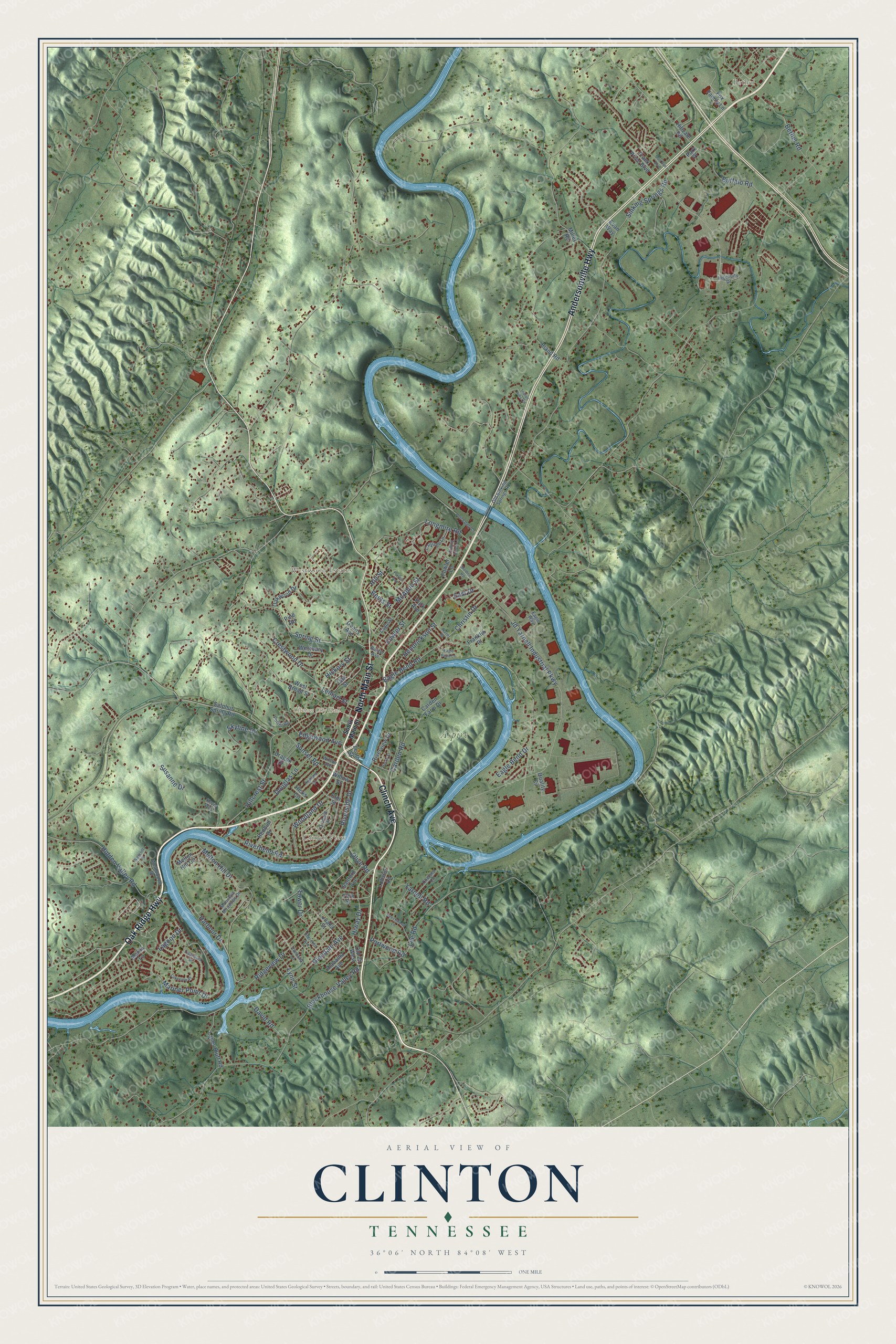
Explore Clinton, Tennessee from a whole new perspective. Created using aerial imagery and detailed geographic data, this map captures Clinton building by building, with labeled streets, familiar landmarks, and shaded topographical relief that highlights the natural contours of the landscape.
Combining modern data with the timeless character of a vintage atlas, this map is just as interesting up close as it is beautiful on the wall. Whether you grew up in Clinton, spent memorable years there, or call it home today, this unique map is a great way to celebrate a place that means something to you. Zoom in on the preview to look for your street, and then order a print to put your memories on the wall.
Three ways to hang it

Unframed archival matte, a black wood frame or a white wood frame.
Up close
Geography Worth Displaying
This map was created using accurate cartographic data and authoritative geographic sources, including the U.S. Geological Survey and the Census Bureau. The map brings together terrain, waterways, roads, and building detail. The majority of the streets are labeled, houses are accurately depicted, and the topography is derived from government sources. Combining local data with carefully composed color and shading leads to this beautifully detailed Clinton artwork for your wall.
Rather than simply showing street outlines, we’ve included as many of the street names as we could reasonably fit on the map while keeping their names legible. Zoom in on the high resolution preview to see exactly what’s on the map. We truly set out to create a statement piece for anyone who loves Clinton. So whether it’s for you, or a gift for someone you love, we hope this map of Clinton brings back fond memories.
Read the story behind this map of Clinton, Tennessee from 2026.

Find your street
Names on the Clinton map
Every name below is printed on this map. Look for your street, your school, the park where you played, or the pond down the road.
Places and landmarks5
- Clinton City Hall
- Aspire
- Bethel
- Westwood Estates
- Clinch View
Streets and roads113
- Andersonville Highway
- Oak Ridge Highway
- Clinch Avenue
- North Main Street
- Mariner Point Drive
- Riverside Drive
- Harbour Drive
- Jd Yarnell Industrial Parkway
- Eagle Bend Road
- Ridgeview Drive
- Melton Hill Drive
- Yarnell Road
- Blockhouse Valley Road
- Hillcrest Street
- Hiway Drive
- Spring Street
- Lee Road
- Riverbend Road
- Carden Road
- Sinking Springs Road
- Susanne Drive
- Skyline Drive
- Woodland Drive
- Buffalo Road
- Fowler Street
- Hidden Valley Road
- Longmire Road
- McAdoo Street
- Hendrickson Street
- Glendale Avenue
Show all 113 streets
- Sunset Road
- Christin Drive
- Leinart Street
- Douglas Lane
- Edgewood Avenue
- Lynn Street
- Eagle Bend Drive
- Portwood Road
- Crestwood Drive
- Tower Drive
- Beets Street
- David Road
- Hickory Street
- Bethel Road
- Lagoon Drive
- Hill Street
- Olive Road
- East Drive
- West Broad Street
- Leath Street
- Miller Road
- Carden Farm Drive
- Old 25 West
- Melton Hill Circle
- Sulphur Spring Road
- Westbury Drive
- Goans Avenue
- Lanes Bluff Road
- Park Avenue
- Hicks Circle
- Riverview Drive
- Fox Family Lane
- Unaka Street
- Frank Price Boulevard
- Quality Circle
- Redbud Drive
- Oak Street
- Oakwood Drive
- Elm Street
- Sanford Avenue
- Alabama Avenue
- Lobster Lane
- Dragon Drive
- Franklin Place
- Hillvale Road
- Fowler Lane
- Bland Road
- Willow Street
- Evan Way
- Marlin Lane
- Pine Road
- York Street
- Park Place
- South Main Street
- Cagle Street
- Eagle Way
- Wealdwood Drive
- Carriage Lane
- Chelsea Lane
- Mountain Meadows Drive
- Orchard Drive
- Old Sinking Springs Road
- Ingenuity Drive
- Potter Road
- Baxter Avenue
- Lantana Lane
- Wilson Avenue
- Kevin Way
- Cherokee Avenue
- Beechwood Lane
- Tradewind Street
- Lakeview Place
- Forrest Avenue
- Nave Street
- Highland Drive
- Indian Hills Circle
- Pub Safety Lane
- Rolling Acres Lane
- Eagle Bend Lane
- Doe Run Boulevard
- Harris Street
- Weycliff Place
- Modine Road
Names are listed as they appear on the printed map. Zoom into the product photos to find them.
About Clinton, Tennessee
Clinton is a city of 10,056 people and the county seat of Anderson County, on the Clinch River. It began in 1801 as Burrville, named for Aaron Burr, Thomas Jefferson's first vice president, when the new county was formed from parts of Grainger and Knox counties and land was set aside here for a courthouse. Burr later killed Alexander Hamilton in their duel, and on November 8, 1809, the legislature replaced the disgraced name. The town became Clinton, most likely for George Clinton, who had followed Burr as vice president in 1805, though some credit his nephew DeWitt Clinton.
Union Academy opened in Clinton in 1806 and began admitting girls alongside boys in 1817. Later, the Southern Railway depot and the coal mines nearby brought growth, and the town went from about 325 people in 1874 to 1,198 in 1890, the year it incorporated. Magnet Knitting Mills, Clinton's first large factory, opened in 1906 making men's socks with fewer than 60 workers. By 1916 it employed more than 500 and was planning to make women's silk hosiery.
- The Clinton 12 in 1956After Brown v. Board of Education, a court ordered Clinton High School to admit Black students. Twelve of them began classes on August 27, 1956, the first Black students to integrate a state-supported public school in the Southeast. The first day passed calmly, but John Kasper and Asa Carter arrived the next week to stir up white residents, riots broke out, and Governor Frank G. Clement kept the National Guard in town through September.
- A bomb in 1958Threats against Clinton High School went on after the riots, until a bomb hit the building on October 5, 1958. With help from outside the town, the school was quickly rebuilt.
- The Green McAdoo SchoolBefore desegregation, Black children in Clinton went to the Green McAdoo School for their elementary grades, and teenagers had to travel to Knoxville for high school. The old school now holds the Green McAdoo Cultural Center, a museum about the desegregation crisis, and it joined the National Register in 2005.
- The Clinton Engineer WorksDuring World War II, the Manhattan Project's Tennessee site was officially named for Clinton. Starting about 3 miles southwest of town and covering roughly 58,900 acres, it produced the enriched uranium for the 1945 bombing of Hiroshima and the first plutonium made in a reactor. It was also known by the name of its biggest township, Oak Ridge.
- Pearls from the ClinchThe Clinch River beside Clinton was once known for its freshwater pearls. When the Tennessee Valley Authority built Melton Hill Dam in the mid-20th century, the deeper river ran warmer, the mussels lost their habitat, and the pearl harvest came to an end.
Keep exploring Tennessee
Clinton is one of 640 Tennessee towns we've mapped. Every dot on the map is a print of its own.
The search covers every state, Tennessee first.
Near Clinton
Order 2 or more town maps and save 10%. Shown in the size and finish you picked above, so they hang as a set.
- Claxton 12" x 18" / Archival Matte Print $39.99
- Dutch Valley 12" x 18" / Archival Matte Print $39.99
- Briceville 12" x 18" / Archival Matte Print $39.99


More maps nearby: Powell, Karns, Andersonville, Norris and Rocky Top.
The art of mapping a place
How This Map Was Made
Real places. Remarkable detail. Discover the layers that turn geographic data into a map of home.

The view from above
Aerial imagery reveals the character of the land: woodland, open fields, and the patterns of a place.

The shape of the land
Elevation data brings hills, valleys, and subtle changes in the landscape into view.

The details of home
Roads, waterways, and building footprints come together to make the map feel unmistakably local.

Geography becomes art
Considered color, shading, and typography bring the layers together in a map made for your wall.


Process illustrated with Mendon, Massachusetts. Aerial imagery: USDA NAIP. Terrain: USGS 3D Elevation Program. Map details and finished artwork: KNOWOL.
The Details
About This Print
Choose an archival matte print, or a black or white Ayous wood frame. The archival matte print is unframed.
Select your size and finish above to see the matching product image and price.
Materials & Craftsmanship
A contemporary map with the character of a classic atlas, printed on archival matte paper. Optional frames are made from Ayous wood.
Your printed map does not include the watermark shown in the full-map preview.
Shipping & Delivery
Free shipping within the United States. Every print is made to order in the USA.
Buying a gift? Add a note in your cart and we'll include it. We never put prices in the package.
Prints ship within 2 to 3 business days. Allow 7 to 10 days total from ordering for delivery. Timing may vary during holidays or periods of high order volume.
Read our shipping policy.
Returns and damaged prints
Each print is made to order. Change-of-mind refunds are not available after production.
If your print arrives damaged, misprinted or incorrect, contact support@knowol.com within 30 days of receiving it. Include your order number, photos and a description of the issue.
Read our full refund and replacement policy. For questions about your order, email support@knowol.com.