


Search for another town


Free U.S. delivery 7 to 10 days after you order
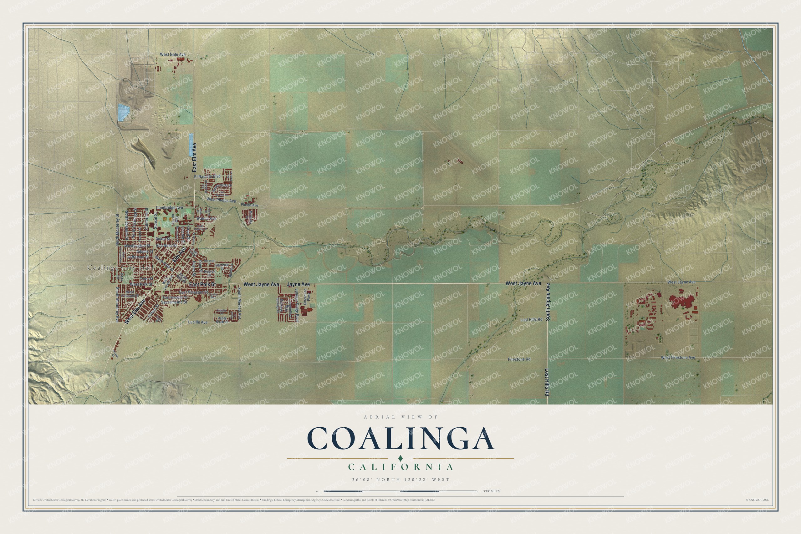
Coalinga, California Map Art
Building by building, with labeled streets and shaded relief.
12" x 18" Archival Matte Print
A Map of Home. A Work of Art.
Explore Coalinga, California from a whole new perspective. Created using aerial imagery and detailed geographic data, this map captures Coalinga building by building, with labeled streets, familiar landmarks, and shaded topographical relief that highlights the natural contours of the landscape.
Combining modern data with the timeless character of a vintage atlas, this map is just as interesting up close as it is beautiful on the wall. Whether you grew up in Coalinga, spent memorable years there, or call it home today, this unique map is a great way to celebrate a place that means something to you. Zoom in on the preview to look for your street, and then order a print to put your memories on the wall.
Three ways to hang it

Unframed archival matte, a black wood frame or a white wood frame.
Up close
Geography Worth Displaying
This map was created using accurate cartographic data and authoritative geographic sources, including the U.S. Geological Survey and the Census Bureau. The map brings together terrain, waterways, roads, and building detail. The majority of the streets are labeled, houses are accurately depicted, and the topography is derived from government sources. Combining local data with carefully composed color and shading leads to this beautifully detailed Coalinga artwork for your wall.
Rather than simply showing street outlines, we’ve included as many of the street names as we could reasonably fit on the map while keeping their names legible. Zoom in on the high resolution preview to see exactly what’s on the map. We truly set out to create a statement piece for anyone who loves Coalinga. So whether it’s for you, or a gift for someone you love, we hope this map of Coalinga brings back fond memories.
Read the story behind this map of Coalinga, California from 2026.

Find your street
Names on the Coalinga map
Every name below is printed on this map. Look for your street, your school, the park where you played, or the pond down the road.
Places and landmarks1
- Coalinga City Hall
Streets and roads72
- Elm Avenue
- East Elm Avenue
- West Elm Avenue
- South Alpine Avenue
- West Jayne Avenue
- East Polk Street
- Lost Hills Road
- Jayne Avenue
- South Monterey Avenue
- North Monterey Street
- Washington Street
- Van Ness Street
- West Phelps Avenue
- Cambridge Avenue
- West Polk Street
- Sunset Street
- Forest Street
- South Merced Avenue
- North Coalinga Street
- California Street
- West Firestone Avenue
- Lucille Avenue
- North Joaquin Street
- East Pleasant Street
- Baker Street
- West Gale Avenue
- Firestone Road
- Juniper Ridge Boulevard
- El Rancho Boulevard
- Sacramento Street
Show all 72 streets
- Pine Street
- Tyler Street
- Jefferson Street
- Adams Street
- North Fifth Street
- Hayes Street
- Walnut Avenue
- Grant Street
- Lincoln Street
- Phelps Avenue
- South Fifth Street
- West Forest Avenue
- Alicia Lane
- Longhollow Way
- Petite Sirah Lane
- Fresno Street
- West Pleasant Street
- East Houston Street
- Buckeye Springs Street
- Buena Vista Drive
- Harrison Street
- Enterprise Parkway
- Hoover Street
- Falcon Way
- Michelle Street
- Keck Lane
- Tache Way
- Buchanan Street
- East Cherry Lane
- Truman Street
- Via Robles Drive
- South First Street
- Chablis Lane
- Pinto Street
- North Princeton Avenue
- Maple Road
- Alcalde Road
- Roosevelt Street
- Chianti Circle
- San Madele Avenue
- Folsom Road
- San Pablo Drive
Names are listed as they appear on the printed map. Zoom into the product photos to find them.
About Coalinga, California
Coalinga is a city of 17,590 people in Fresno County, in the Pleasant Valley on the western side of the San Joaquin Valley. Steam trains crossing the valley burned coal dug near Mount Diablo, so in 1888 the Southern Pacific Railroad made this spot a fuel stop and called it Coaling Station A. One local story says a railroad official added an extra letter to make the name sound better. It's just as likely that the small trackside signs shortened the name to COALINGA. A post office opened in 1899, and the city was incorporated in 1906.
Oil soon mattered more than coal, and the Coalinga Oil Field still wraps around the town. In the early 1900s, though, the local wells gave water nobody could drink. The city, then about 5,000 people, brought drinking water in by rail tanker from Armona and paid for a separate set of pipes to deliver it, so every home had a third faucet. By the mid-1900s a reverse-osmosis system made the town's water safe, and the third faucet was no longer needed.
- The earthquake of 1983On May 2, 1983, a magnitude 6.5 earthquake struck Coalinga. More than 300 homes and apartment buildings were nearly destroyed, 691 other buildings were badly damaged, and the eight-block downtown business district was almost completely wrecked. People felt the shaking as far off as Los Angeles. One man died, of a heart attack.
- Horned Toad Derby since 1935Every Memorial Day weekend, Coalinga holds its three-day Horned Toad Derby. The idea is much like the Jumping Frog Jubilee in Calaveras County, but the racers here are horned lizards caught around town. The tradition started in 1935.
- Balloons every NovemberThe WHAMOBASS Balloon Rally comes to Coalinga each year on the November weekend nearest Montgolfiere Day, November 21. It is the longest unbroken run of any annual hot air balloon rally in the world, and more than 40 balloons usually lift off at dawn from the West Hills College athletic field.
- Polk Street SchoolCoalinga's school planners chose the Polk Street School, on the east side of the city limits, as their first building in 1907. The Coalinga Polk Street School joined the National Register of Historic Places in 1982.
- A singer and a bitcoin pioneerCoalinga is linked to Jo Stafford, the Grammy-winning singer and television host, and to Hal Finney, the computer scientist who invented a reusable proof-of-work system that helped make bitcoin possible. Pat and Lolly Vegas of the rock band Redbone, honored in 2008 with places in the Native American Music Hall of Fame, also have ties to the town.
Keep exploring California
Coalinga is one of 1,990 California towns we've mapped. Every dot on the map is a print of its own.
The search covers every state, California first.
Near Coalinga
Order 2 or more town maps and save 10%. Shown in the size and finish you picked above, so they hang as a set.
- Avenal 12" x 18" / Archival Matte Print $39.99
- Huron 12" x 18" / Archival Matte Print $39.99
- Parkfield 12" x 18" / Archival Matte Print $39.99


More maps nearby: Westside, Kettleman City, Cantua Creek, Lemoore Station and Three Rocks.
The art of mapping a place
How This Map Was Made
Real places. Remarkable detail. Discover the layers that turn geographic data into a map of home.

The view from above
Aerial imagery reveals the character of the land: woodland, open fields, and the patterns of a place.

The shape of the land
Elevation data brings hills, valleys, and subtle changes in the landscape into view.

The details of home
Roads, waterways, and building footprints come together to make the map feel unmistakably local.

Geography becomes art
Considered color, shading, and typography bring the layers together in a map made for your wall.


Process illustrated with Mendon, Massachusetts. Aerial imagery: USDA NAIP. Terrain: USGS 3D Elevation Program. Map details and finished artwork: KNOWOL.
The Details
About This Print
Choose an archival matte print, or a black or white Ayous wood frame. The archival matte print is unframed.
Select your size and finish above to see the matching product image and price.
Materials & Craftsmanship
A contemporary map with the character of a classic atlas, printed on archival matte paper. Optional frames are made from Ayous wood.
Your printed map does not include the watermark shown in the full-map preview.
Shipping & Delivery
Free shipping within the United States. Every print is made to order in the USA.
Buying a gift? Add a note in your cart and we'll include it. We never put prices in the package.
Prints ship within 2 to 3 business days. Allow 7 to 10 days total from ordering for delivery. Timing may vary during holidays or periods of high order volume.
Read our shipping policy.
Returns and damaged prints
Each print is made to order. Change-of-mind refunds are not available after production.
If your print arrives damaged, misprinted or incorrect, contact support@knowol.com within 30 days of receiving it. Include your order number, photos and a description of the issue.
Read our full refund and replacement policy. For questions about your order, email support@knowol.com.