
Search for another town


Free U.S. delivery 7 to 10 days after you order
Crossville, Tennessee Map Art
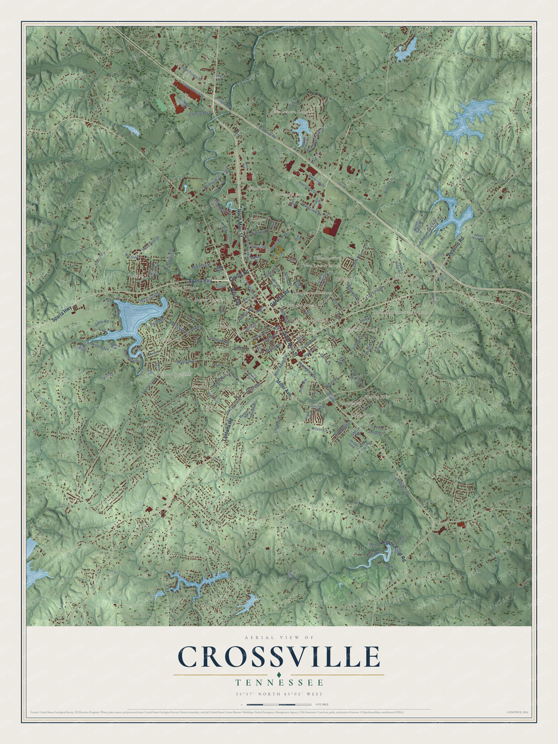
Building by building, with labeled streets and shaded relief.
12" x 18" Archival Matte Print
A Map of Home. A Work of Art.
Explore Crossville, Tennessee from a whole new perspective. Created using aerial imagery and detailed geographic data, this map captures Crossville building by building, with labeled streets, familiar landmarks, and shaded topographical relief that highlights the natural contours of the landscape.
Combining modern data with the timeless character of a vintage atlas, this map is just as interesting up close as it is beautiful on the wall. Whether you grew up in Crossville, spent memorable years there, or call it home today, this unique map is a great way to celebrate a place that means something to you. Zoom in on the preview to look for your street, and then order a print to put your memories on the wall.
Three ways to hang it

Unframed archival matte, a black wood frame or a white wood frame.
Up close
Geography Worth Displaying
This map was created using accurate cartographic data and authoritative geographic sources, including the U.S. Geological Survey and the Census Bureau. The map brings together terrain, waterways, roads, and building detail. The majority of the streets are labeled, houses are accurately depicted, and the topography is derived from government sources. Combining local data with carefully composed color and shading leads to this beautifully detailed Crossville artwork for your wall.
Rather than simply showing street outlines, we’ve included as many of the street names as we could reasonably fit on the map while keeping their names legible. Zoom in on the high resolution preview to see exactly what’s on the map. We truly set out to create a statement piece for anyone who loves Crossville. So whether it’s for you, or a gift for someone you love, we hope this map of Crossville brings back fond memories.
Read the story behind this map of Crossville, Tennessee from 2026.

Find your street
Names on the Crossville map
Every name below is printed on this map. Look for your street, your school, the park where you played, or the pond down the road.
Places and landmarks25
- Harrison Addition
- Lake Genesis Country
- Storie
- Dayton Spur
- Oaklyn
- Woodlawn
- South Hills
- Town Branch Estates
- Camelot
- Holiday Hills
- Greenbriar Village
- Highland Homesite Addition
Show all 25 places
- Hale
- Sparta Heights
- Rolling Hills
- Hide-a-Way Hills
- Maplewood Estates
- Hillcrest
- Sunset Terrace
- Crossville Estates
- Glendale
- Parkview
- Meadowview
- Lynwood Acres
- Brookhaven
Streets and roads151
- North Main Street
- Lantana Road
- West Avenue
- Sparta Highway
- Miller Avenue
- Genesis Road
- South Main Street
- Peavine Road
- Pigeon Ridge Road
- Elmore Road
- Deerfield Road
- East First Street
- Tennessee Avenue
- Holiday Drive
- Cook Road
- Northside Drive
- East Deer Creek Drive
- Old Jamestown Highway
- Stanley Street
- Interstate Drive
- Livingston Road
- Industrial Boulevard
- Fourth Street
- Dayton Avenue
- Crabtree Road
- Old Mail Road
- Spruce Loop
- Cumberland View Drive
- Hillcrest Drive
- Webb Avenue
Show all 151 streets
- Myrtle Avenue
- Villageway
- Waterview Drive
- Creekway Drive
- Dorton Road
- Interchange Drive
- Woodlawn Road
- Riverbend Drive
- Commercial Drive
- Cabin Drive
- Wilson Lane
- Tenth Street
- Bob White Drive
- West Adams Street
- Iris Circle
- Wells Road
- Old Highway Circle
- Charleston Lane
- Sweeney Drive
- Holly Tree Drive
- Kings Row
- Crossroads Drive
- Riverchase Drive
- Dooley Street
- Maryetta Street
- Spiers Way
- Southgate Drive
- Netherton Lane
- Central Avenue
- Dunbar Lane
- Taylor Street
- Hayes Street
- Huddle Road
- Southbend Drive
- Obrien Drive
- Hollis Lane
- Stable Road
- Jantel Drive
- Frost Road
- Stone Drive
- Park Lane
- Pony Run
- Dunn Avenue
- County Garage Road
- Bible Way
- Swim Drive
- Storie Avenue
- Wayne Avenue
- Old Lantana Road
- Camp Drive
- Park Trace Drive
- Shepherds Way
- County Seat Road
- Play Drive
- Cleveland Street
- Ivy Avenue
- McLarty Lane
- Hyder Ridge Road
- Grove Loop
- Jordan Loop
- Albert Frye Road
- Porcelain Tile Drive
- Dove Drive
- Tulip Drive
- Phillips Drive
- Morgan Road
- Justice Street
- Willow Ridge Drive
- Beehive Lane
- Graham Road
- Walker Street
- Red Oak Drive
- Tabor Drive
- Bluff Road
- Town Loop
- Harper Lane
- Goose Pointe
- Hillsway
- Holiday Court
- Lee Street
- Keyes Street
- Wyatt Court
- Obed Street
- South Drive
- Obed Lane
- Little Boulevard
- Duer Court
- Highland Square
- Canary Drive
- Golf Club Lane
- Regency Parkway
- North Street
- East Adams Street
- Blackberry Drive
- Quail Ridge Drive
- Yvonne Avenue
- Knights Way
- Tomlon Road
- South Old Mail Road
- Isham Street
- Red Dog Saloon Road
- Davidson Court
- Mockingbird Drive
- Enterprise Drive
- Brookhaven Drive
- Riverview Drive
- Ridgeway
- Cottonpatch Drive
- Village Lane
- Complex Drive
- Thompson Lane
- Peterbilt Lane
- Brook Street
- River Otter Drive
- Flamingo Drive
- Bilbrey Street
- Louise Street
- Chelsea Drive
- Chestnut Hill Road
- Cox Avenue
- Jada Drive
Names are listed as they appear on the printed map. Zoom into the product photos to find them.
About Crossville, Tennessee
Crossville is a city of 12,071 people and the county seat of Cumberland County, high on the Cumberland Plateau. It grew where two old routes met: a branch of the Great Stage Road between Knoxville and Nashville, and the Kentucky Stock Road, a path cattle drovers used. Around 1800 Samuel Lambeth opened a store at that junction, near today's Main and Stanley Streets, and the settlement around it was called Lambeth's Crossroads.
The community had become Crossville by the time it got a post office in the 1830s. A Sparta merchant named James Scott took over Lambeth's store in the early 1850s and gave it a new name, Scott's Tavern. Cumberland County was formed in 1856, and Crossville won the county seat because it sat closest to the center, even though Pleasant Hill, Mayland, Grassy Cove and Crab Orchard all had more people. Scott gave the first 40 acres for the courthouse and town square.
- Raided from both sidesThe good roads that built Crossville also left it exposed during the Civil War. Union and Confederate troops and bands of renegade guerrillas all plundered the area. The county sent about as many soldiers to one side as the other, so neighbors and even families fought each other.
- The Cumberland HomesteadsDuring the Great Depression, the federal Subsistence Homestead Division started the Cumberland Homesteads south of town to give small farms to several hundred poor families. First Lady Eleanor Roosevelt came to Crossville and the project in 1934. The project's recreation area later grew into Cumberland Mountain State Park.
- Sergeant York's contractWhen Sergeant York came home, he arrived at Crossville's Tennessee Central Depot, where friends from Pall Mall in nearby Fentress County greeted him. In 1940 he returned to Crossville and signed the contract for the film Sergeant York at the Hotel Taylor.
- Built of Crab Orchard StoneMany of Crossville's buildings are made of Crab Orchard Stone, a local building stone. A 1930s Tennessee Highway Patrol station on the courthouse square now houses the Native Stone Museum, devoted to that stone, and the building joined the National Register in 2003. The Palace Theatre has served as a theater and meeting hall since it opened in 1938.
Keep exploring Tennessee
Crossville is one of 640 Tennessee towns we've mapped. Every dot on the map is a print of its own.
The search covers every state, Tennessee first.
Near Crossville
Order 2 or more town maps and save 10%. Shown in the size and finish you picked above, so they hang as a set.
- Lake Tansi 12" x 18" / Archival Matte Print $39.99
- Bowman 12" x 18" / Archival Matte Print $39.99
- Crab Orchard 12" x 18" / Archival Matte Print $39.99


More maps nearby: Homestead, Fairfield Glade, Pleasant Hill, Mayland and Clarkrange.
The art of mapping a place
How This Map Was Made
Real places. Remarkable detail. Discover the layers that turn geographic data into a map of home.

The view from above
Aerial imagery reveals the character of the land: woodland, open fields, and the patterns of a place.

The shape of the land
Elevation data brings hills, valleys, and subtle changes in the landscape into view.

The details of home
Roads, waterways, and building footprints come together to make the map feel unmistakably local.

Geography becomes art
Considered color, shading, and typography bring the layers together in a map made for your wall.


Process illustrated with Mendon, Massachusetts. Aerial imagery: USDA NAIP. Terrain: USGS 3D Elevation Program. Map details and finished artwork: KNOWOL.
The Details
About This Print
Choose an archival matte print, or a black or white Ayous wood frame. The archival matte print is unframed.
Select your size and finish above to see the matching product image and price.
Materials & Craftsmanship
A contemporary map with the character of a classic atlas, printed on archival matte paper. Optional frames are made from Ayous wood.
Your printed map does not include the watermark shown in the full-map preview.
Shipping & Delivery
Free shipping within the United States. Every print is made to order in the USA.
Buying a gift? Add a note in your cart and we'll include it. We never put prices in the package.
Prints ship within 2 to 3 business days. Allow 7 to 10 days total from ordering for delivery. Timing may vary during holidays or periods of high order volume.
Read our shipping policy.
Returns and damaged prints
Each print is made to order. Change-of-mind refunds are not available after production.
If your print arrives damaged, misprinted or incorrect, contact support@knowol.com within 30 days of receiving it. Include your order number, photos and a description of the issue.
Read our full refund and replacement policy. For questions about your order, email support@knowol.com.