


Search for another town


Free U.S. delivery 7 to 10 days after you order
Fairfield Glade, Tennessee Map Art
Building by building, with labeled streets and shaded relief.
12" x 18" Archival Matte Print
A Map of Home. A Work of Art.
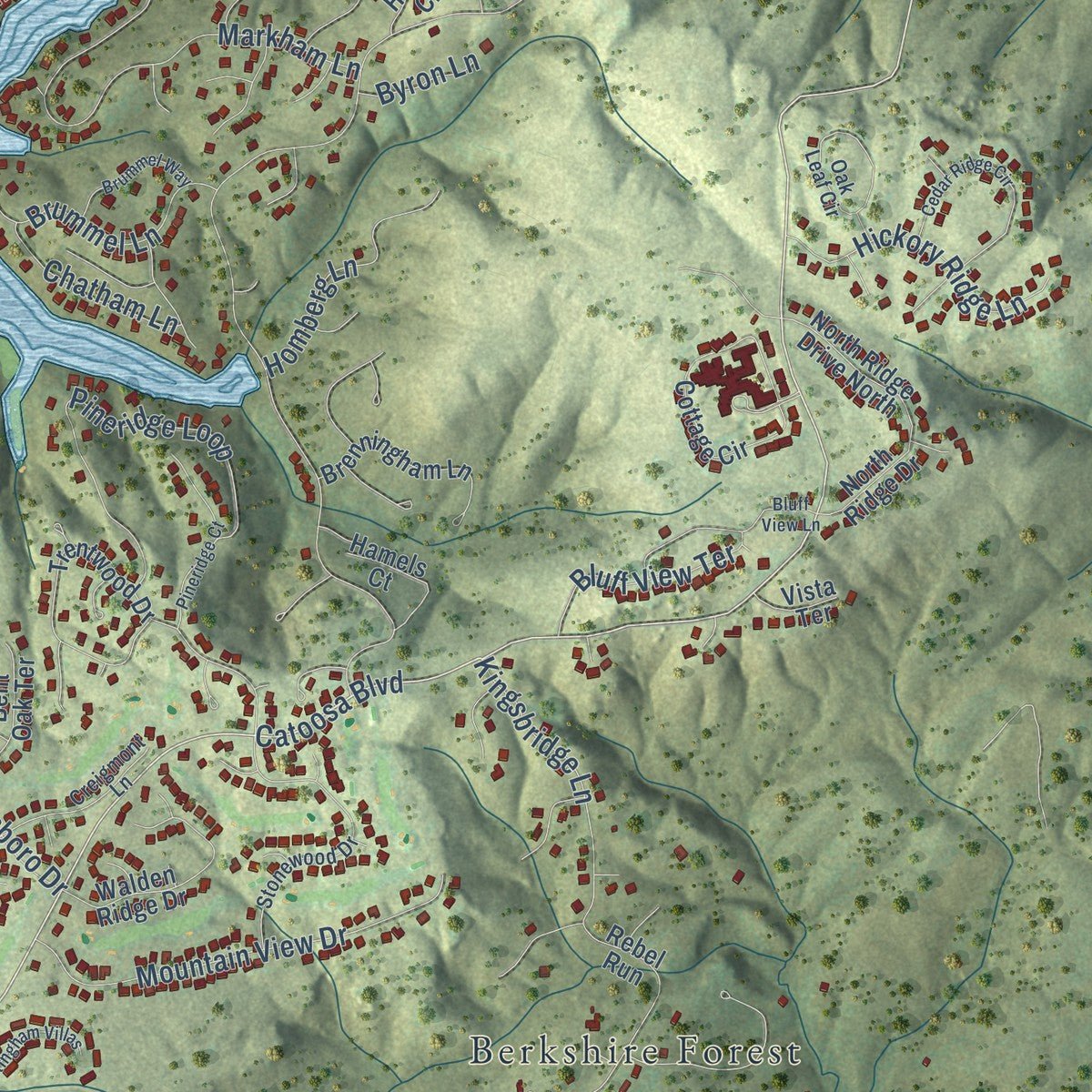
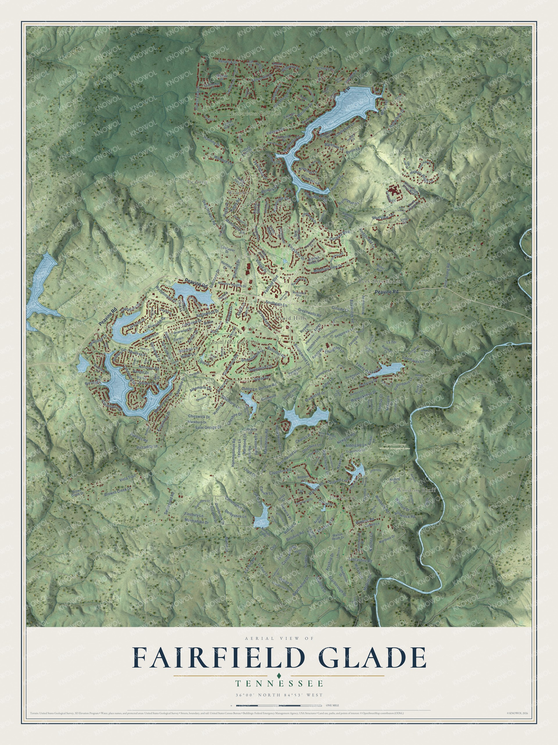
Explore Fairfield Glade, Tennessee from a whole new perspective. Created using aerial imagery and detailed geographic data, this map captures Fairfield Glade building by building, with labeled streets, familiar landmarks, and shaded topographical relief that highlights the natural contours of the landscape.
Combining modern data with the timeless character of a vintage atlas, this map is just as interesting up close as it is beautiful on the wall. Whether you grew up in Fairfield Glade, spent memorable years there, or call it home today, this unique map is a great way to celebrate a place that means something to you. Zoom in on the preview to look for your street, and then order a print to put your memories on the wall.
Three ways to hang it
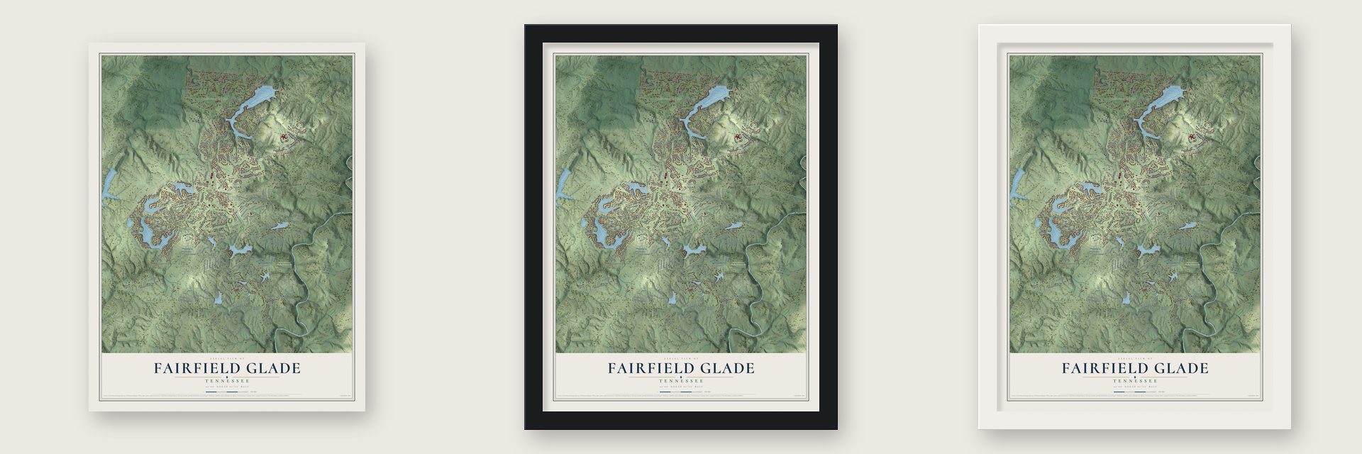
Unframed archival matte, a black wood frame or a white wood frame.
Up close
Geography Worth Displaying
This map was created using accurate cartographic data and authoritative geographic sources, including the U.S. Geological Survey and the Census Bureau. The map brings together terrain, waterways, roads, and building detail. The majority of the streets are labeled, houses are accurately depicted, and the topography is derived from government sources. Combining local data with carefully composed color and shading leads to this beautifully detailed Fairfield Glade artwork for your wall.
Rather than simply showing street outlines, we’ve included as many of the street names as we could reasonably fit on the map while keeping their names legible. Zoom in on the high resolution preview to see exactly what’s on the map. We truly set out to create a statement piece for anyone who loves Fairfield Glade. So whether it’s for you, or a gift for someone you love, we hope this map of Fairfield Glade brings back fond memories.
Read the story behind this map of Fairfield Glade, Tennessee from 2026.

Find your street
Names on the Fairfield Glade map
Every name below is printed on this map. Look for your street, your school, the park where you played, or the pond down the road.
Places and landmarks9
- Windsor Bluff
- Keyes-Harrison Wildlife Management Area
- Berkshire Forest
- Dochester
- Druid Hills
- Peavine
- Wiltshire
- Druid Hills Golf Club
- Heatherhurst Golf Club
Streets and roads311
- Peavine Road
- Catoosa Boulevard
- Westchester Drive
- Stonehenge Drive
- Hunterwood Lane
- Cantabury Drive
- Saint George Drive
- Lakeview Drive
- Snead Drive
- Marmaduke Drive
- Rotherham Drive
- Bainbridge Road
- Beechwood Drive
- Forest Hill Drive
- Orlie Young Road
- Browns Creek Drive
- Wimberly Road
- Dartmoor Drive
- Manchester Road
- Kingsdown Drive
- Lakewood Drive
- Malvern Road
- Cappshire Road
- Warwickshire Drive
- Forest View Drive
- Pomeroy Drive
- Markham Lane
- Lakeside Drive
- Lakeshire Drive
- Kingsboro Drive
Show all 311 streets
- Beachwood Drive
- Windsor Road
- Havenridge Circle
- Lynhurst Drive
- Meadowview Drive
- Hammersmith Road
- Sheffield Drive
- Albemarle Circle
- Albemarle Lane
- Pineridge Loop
- Ivybrook Lane
- Village Drive
- Mariners Drive
- Anglewood Drive
- Scarborough Drive
- Drew Howard Road
- Mountain View Drive
- Berlingwood Lane
- Fairfield Boulevard
- Peebles Road
- Stafford Drive
- Natchez Circle
- Cromwell Lane
- Kingsbridge Lane
- Valarian Drive
- Delbridge Lane
- Rugby Road
- Lisa Lane
- Tawny Oak Loop
- Dublin Lane
- Aryshire Drive
- Brokenwood Lane
- Lancashire Road
- Swicegood Road
- Chicswick Drive
- Leyden Drive
- Dovenshire Drive
- Piccadilly Lane
- Wexford Lane
- Bramleton Drive
- Milnor Terrace
- Baltusrol Road
- Sugarbush Circle
- Newgate Road
- Aldergate Lane
- Castlewood Road
- Greenwood Road
- Norcross Road
- Greenwells Road
- Glenwood Drive
- McDuff Drive
- Hickory Ridge Lane
- Chelteham Lane
- Overlook Cv
- Motthaven Drive
- Rutgers Circle
- Hanning Drive
- Wanford Drive
- Christopher Lane
- Harlech Lane
- Hawes Circle
- Dalefield Loop
- Otterburn Lane
- Brummel Lane
- Martin Lane
- Derbyshire Lane
- Vista Trail
- Homberg Lane
- Exeter Drive
- Leinster Lane
- Carrick Lane
- Westminster Court
- Shore Lane
- Adler Lane
- Eli Ford Road
- Bluff View Terrace
- Ls Terrace
- Belshire Road
- Dunkey
- Folkstone Road
- Arrowrock Road
- Southgate Lane
- Lynnhaven Lane
- Finsbury Lane
- Hamlet Drive
- Donnbrook Drive
- Shelley Lane
- Fairway Drive
- Thames Court
- Springdale Drive
- Chatham Lane
- Seyton Drive
- Berwick Court
- Ivy Lane
- Renwick Drive
- Burrough Lane
- Marlbond Court
- Effingham Lane
- Juniper Drive
- Eagle Lane
- Monticello Lane
- Clifside Court
- Charles Place
- Lloyd Court
- Wilbourn Drive
- Rugby Place
- Cheshire Drive
- Winslow Lane
- Ivydale Lane
- Harwick Place
- Durham Road
- Thomas Court
- Byron Lane
- Hilton Lane
- Celt
- Oak Knoll
- Birchwood Circle
- Trentwood Drive
- Cottage Circle
- Rebel Run
- Blackburn Drive
- Newcastle Lane
- Wycliff Lane
- Brairhill Loop
- Broadstone Drive
- Harley Circle
- Walden Ridge Drive
- Amherst Lane
- Marlboro Drive
- Lechmere Drr
- Lafayette Lane
- Brenningham Lane
- Thornhill Lane
- Jasper Drive
- Willshire Heights Drive
- Minetta Drive
- Brown Creek Drive
- Windcrest Road
- Kipling Drive
- Laswell Lane
- Staffordshire Lane
- Elizabeth Drive
- Oakburn Court
- Cathedral Drive
- Pembroke Circle
- Travistock Lane
- Sedgemoor Lane
- Briarwood Drive
- Prestonwood Drive
- McFarlin Drive
- Sunderland Circle
- Kingsboro Lane
- Prescott Lane
- North Ridge Drive North
- Lancaster Drive
- Walton Heath Drive
- Darwin Lane
- Andover Lane
- Ferndale Lane
- Beachwood Lane
- Hickory Cove Lane
- Bent Oak Terrace
- Bradford Lane
- Eli Ford Court
- Brooks Lane
- Markham Terrace
- Rochdale Lane
- Hamels Court
- Lindsey Knoll Court
- Robin Hood Court
- Huntington Drive
- Dylan Lane
- Norman Loop
- Heather Glen Drive
- Woodmere Place
- Wickham Lane
- Rodman Court
- Conrad Court
- Foxwell Lane
- Hertford Drive
- North Ridge Drive
- Chipman Plaza
- Valarian Terrace
- Avalon Road
- Gower Lane
- Laurel Ridge
- Hanes Circle
- Howard Terrace
- Brixton Lane
- Jana Drive
- Lenox Court
- Holly Lane
- Rocky Top Terrace
- Vista Terrace
- Britton Lane
- Forest Hill Terrace
- Lisa Court
- Abbey Place
- Cole Court
- Leaf Lane
- Maintence Boulevard
- Dartmore Drive
- Stonewood Drive
- Buckingham Drive
- Darrow Lane Terrace
- Oak Leaf Circle
- Banbury Lane
- Barberry Drive
- Thrushwood Drive
- Brentwood Place
- Ashmore Lane
- Chamberlain Drive
- Shannondale Lane
- Creigmont Lane
- Laurelton Lane
- Eagle Court
- Castlebridge Lane
- Hurstwood Lane
- Innisbrooke Terrace
- Glastonbury Court
- Lytham Way
- Morris Lane
- Belvedere Lane
- Romney Lane
- Knollcrest Terrace
- Wellington Court
- Cheshire Terrace
- Hampshire Lane
- Trafalgar Drive
- Knight Court
- Cavalier Lane
- Halifax Court
- Briar Court
- Farthing Court
- Camden Court
- Inwood Drive
- Pamala Lane
- Dover Lane
- Friar Lane
- Overlook Terrace
- Victoria Way
- Dane
- Felix Court
- Wanford Court
- Crestwood Drive
- Walsingham Lane
- Cedar Ridge Circle
- Hedgewood Point
- Lake Catherine Circle
- Lauvel Wood Drive
- Bluff View Lane
- Pineridge Court
- Yorkshire Terrace
- Liverpool Circle
- Hathaway Drive
- Stillington Loop
- Brummel Way
- Warehouse Road
- Nottingham Villas
- Claremont Circle
- Bellwood Road
- Albemarle Place
- Greenleaf Court
- Edgemere Drive
- Windsor Terrace
- Prigmore Lane
- Carnoustie Drive
- Laver Lane
- Camberly Place
- Clason Point
- Ashford Place
- Cerknwell Place
- Warington Road
- Lindrick Place
- London Court
- Keswick Lane
- Nesbit Cros
- Dickens Lane
- Heiskell Court
- Artella Court
- Forman Court
Names are listed as they appear on the printed map. Zoom into the product photos to find them.
About Fairfield Glade, Tennessee
From the Fairfield Glade Police Department: "The Fairfield Glade Police Department serves the Fairfield Glade Community Club which is located in Cumberland County, Tennessee just north of the City of Crossville."
Keep exploring Tennessee
Fairfield Glade is one of 640 Tennessee towns we've mapped. Every dot on the map is a print of its own.
The search covers every state, Tennessee first.
Near Fairfield Glade
Order 2 or more town maps and save 10%. Shown in the size and finish you picked above, so they hang as a set.
- Crab Orchard 12" x 18" / Archival Matte Print $39.99
- Crossville 12" x 18" / Archival Matte Print $39.99
- Bowman 12" x 18" / Archival Matte Print $39.99


More maps nearby: Homestead, Lake Tansi, Rockwood, Clarkrange and Wartburg.
The art of mapping a place
How This Map Was Made
Real places. Remarkable detail. Discover the layers that turn geographic data into a map of home.

The view from above
Aerial imagery reveals the character of the land: woodland, open fields, and the patterns of a place.

The shape of the land
Elevation data brings hills, valleys, and subtle changes in the landscape into view.

The details of home
Roads, waterways, and building footprints come together to make the map feel unmistakably local.

Geography becomes art
Considered color, shading, and typography bring the layers together in a map made for your wall.


Process illustrated with Mendon, Massachusetts. Aerial imagery: USDA NAIP. Terrain: USGS 3D Elevation Program. Map details and finished artwork: KNOWOL.
The Details
About This Print
Choose an archival matte print, or a black or white Ayous wood frame. The archival matte print is unframed.
Select your size and finish above to see the matching product image and price.
Materials & Craftsmanship
A contemporary map with the character of a classic atlas, printed on archival matte paper. Optional frames are made from Ayous wood.
Your printed map does not include the watermark shown in the full-map preview.
Shipping & Delivery
Free shipping within the United States. Every print is made to order in the USA.
Buying a gift? Add a note in your cart and we'll include it. We never put prices in the package.
Prints ship within 2 to 3 business days. Allow 7 to 10 days total from ordering for delivery. Timing may vary during holidays or periods of high order volume.
Read our shipping policy.
Returns and damaged prints
Each print is made to order. Change-of-mind refunds are not available after production.
If your print arrives damaged, misprinted or incorrect, contact support@knowol.com within 30 days of receiving it. Include your order number, photos and a description of the issue.
Read our full refund and replacement policy. For questions about your order, email support@knowol.com.