
Search for another town


Free U.S. delivery 7 to 10 days after you order
Daly City, California Map Art
Building by building, with labeled streets and shaded relief.
12" x 18" Archival Matte Print
A Map of Home. A Work of Art.
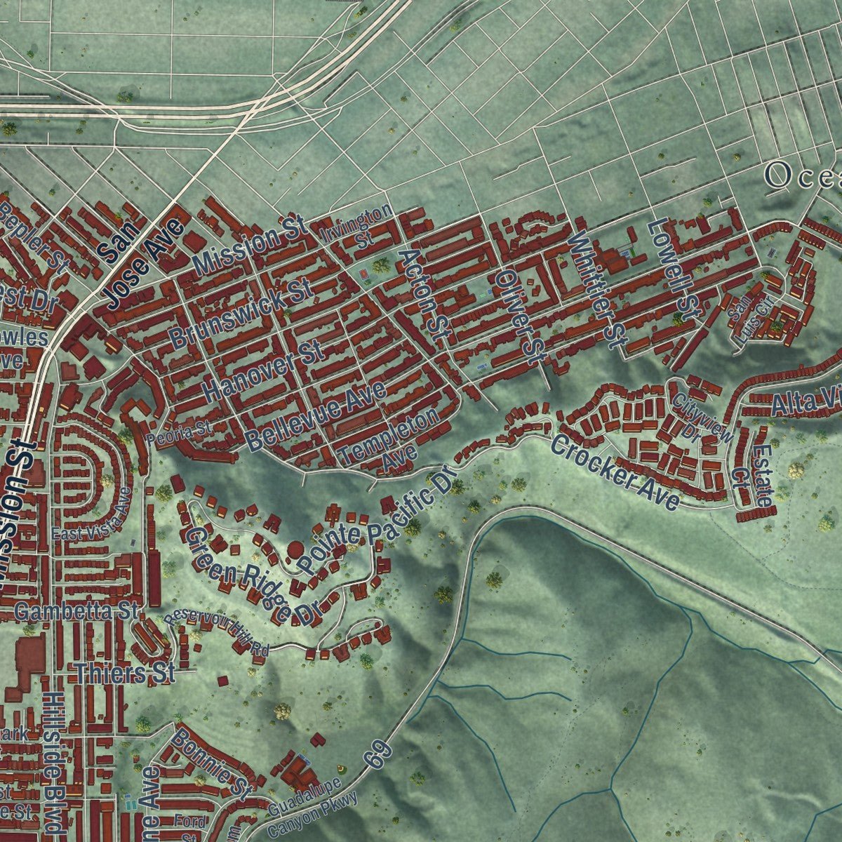
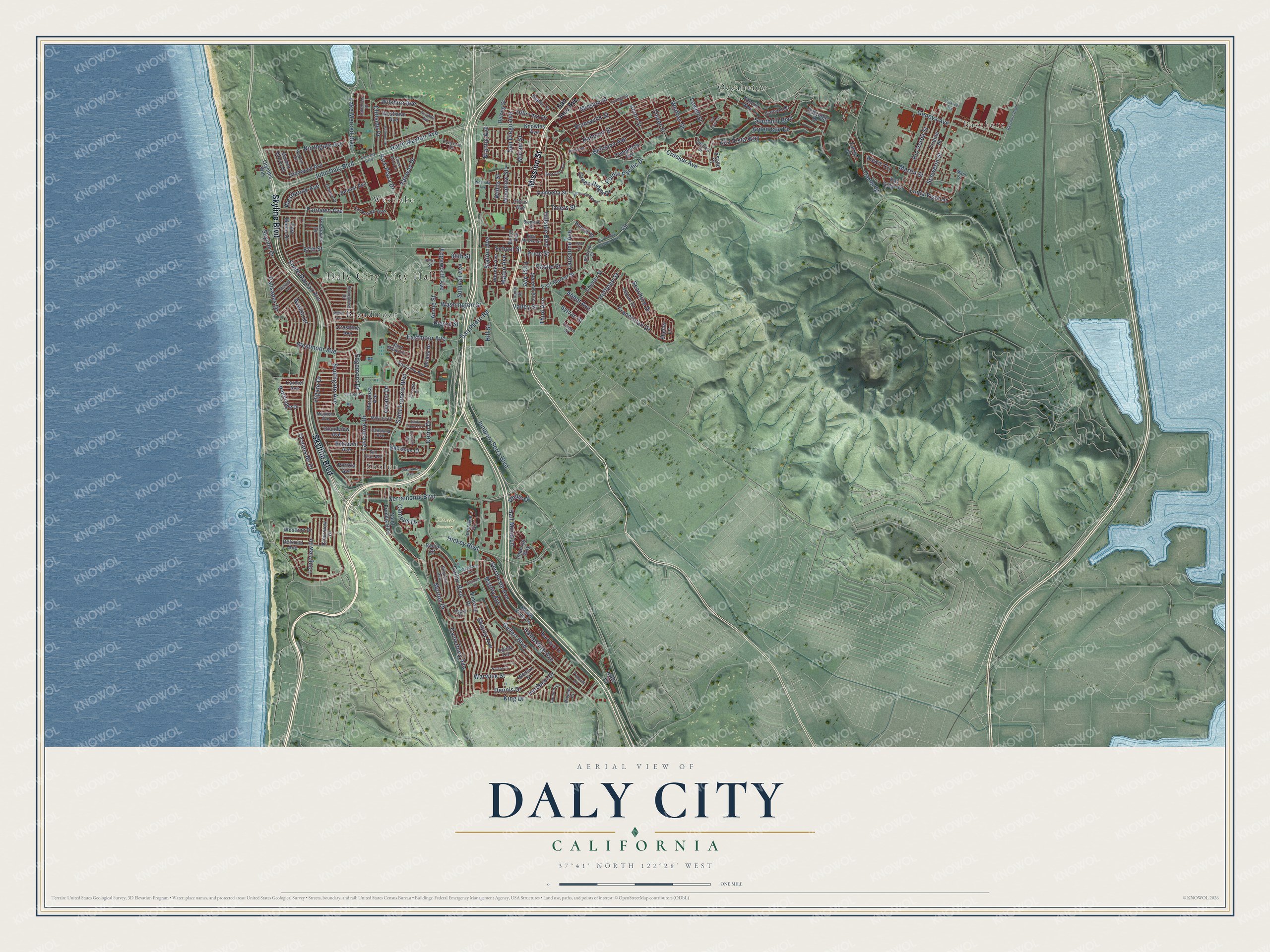
Explore Daly City, California from a whole new perspective. Created using aerial imagery and detailed geographic data, this map captures Daly City building by building, with labeled streets, familiar landmarks, and shaded topographical relief that highlights the natural contours of the landscape.
Combining modern data with the timeless character of a vintage atlas, this map is just as interesting up close as it is beautiful on the wall. Whether you grew up in Daly City, spent memorable years there, or call it home today, this unique map is a great way to celebrate a place that means something to you. Zoom in on the preview to look for your street, and then order a print to put your memories on the wall.
Three ways to hang it

Unframed archival matte, a black wood frame or a white wood frame.
Up close
Geography Worth Displaying
This map was created using accurate cartographic data and authoritative geographic sources, including the U.S. Geological Survey and the Census Bureau. The map brings together terrain, waterways, roads, and building detail. The majority of the streets are labeled, houses are accurately depicted, and the topography is derived from government sources. Combining local data with carefully composed color and shading leads to this beautifully detailed Daly City artwork for your wall.
Rather than simply showing street outlines, we’ve included as many of the street names as we could reasonably fit on the map while keeping their names legible. Zoom in on the high resolution preview to see exactly what’s on the map. We truly set out to create a statement piece for anyone who loves Daly City. So whether it’s for you, or a gift for someone you love, we hope this map of Daly City brings back fond memories.
Read the story behind this map of Daly City, California from 2026.

Find your street
Names on the Daly City map
Every name below is printed on this map. Look for your street, your school, the park where you played, or the pond down the road.
Places and landmarks7
- Daly City City Hall
- Bayshore
- Chinese Cemetery
- Broadmoor
- Oceanview
- Sholun
- Westlake
Streets and roads195
- Mission Street
- Skyline Boulevard
- John Daly Boulevard
- Park Plaza Drive
- Acton Street
- Junipero Serra Boulevard
- Whittier Street
- Bellevue Avenue
- North Mayfair Avenue
- Geneva Avenue
- Brunswick Street
- Crocker Avenue
- Lausanne Avenue
- Rio Verde Street
- Green Ridge Drive
- Cliffside Drive
- Pierce Street
- Annie Street
- Southgate Avenue
- Skyline Drive
- South Mayfair Avenue
- Hickey Boulevard
- Callan Boulevard
- Gellert Boulevard
- Saint Francis Boulevard
- Hillside Boulevard
- King Drive
- Higate Drive
- Sullivan Avenue
- Serramonte Boulevard
Show all 195 streets
- Morton Drive
- Lake Merced Boulevard
- Southhill Boulevard
- Westmoor Avenue
- Hanover Street
- San Diego Avenue
- Carter Street
- Alta Vista Way
- Lakeshire Drive
- Abbot Avenue
- Eastmoor Avenue
- Schwerin Street
- Northgate Avenue
- Price Street
- Martin Street
- Franciscan Drive
- Serravista Avenue
- Palisades Drive
- Wilshire Avenue
- Ardendale Drive
- Dennis Drive
- Shipley Avenue
- Hoffman Street
- Miriam Street
- Avalon Drive
- Longview Drive
- Woodrow Street
- Cerro Drive
- San Pedro Road
- Pointe Pacific Drive
- Canterbury Avenue
- Linda Vista Drive
- Willits Street
- 87th Street
- Niantic Avenue
- Third Avenue
- Edgeworth Avenue
- Warwick Street
- First Avenue
- Marbly Avenue
- Campus Drive
- Washington Street
- Fairlawn Avenue
- Alexis Circle
- Fairway Drive
- Seashore Drive
- Station Avenue
- Westbrook Avenue
- 88th Street
- Hill Street
- Hillcrest Drive
- Castle Street
- Hampshire Avenue
- School Street
- Half Moon Lane
- Edgemont Drive
- Verducci Drive
- Oceanside Drive
- Valley Street
- Oliver Street
- Mateo Avenue
- Thiers Street
- Verano Drive
- Philip Drive
- Lowell Street
- Sylvan Street
- San Jose Avenue
- Glenwood Avenue
- East Market Street
- Templeton Avenue
- Oakridge Drive
- Oriente Street
- Bay Ridge Drive
- Westline Drive
- Northridge Drive
- Chester Street
- Belhaven Avenue
- Mariposa Avenue
- Lycett Circle
- Westlawn Avenue
- Barbara Lane
- Belcrest Avenue
- Coronado Avenue
- Haven Drive
- Imperial Way
- Citrus Avenue
- Knowles Avenue
- Innisfree Drive
- Canyon Drive
- Second Avenue
- Belmar Avenue
- Pinehaven Drive
- Bruno Avenue
- Werner Avenue
- Simpson Drive
- Gambetta Street
- Polaris Way
- Bepler Street
- Belhaven Court
- Delong Street
- Park Manor Drive
- Mirada Drive
- Olympic Way
- Grandview Avenue
- Monte Vista Lane
- Clearview Drive
- Garden Grove Drive
- Bonnie Street
- Carmel Avenue
- Crestline Avenue
- Wessix Court
- Farrier Place
- Shelter Lane
- Estate Court
- Portola Avenue
- Bacon Court
- Hyde Court
- Poncetta Drive
- Irvington Street
- Alta Loma Avenue
- East Moltke Street
- 89th Street
- Cityview Drive
- Camelot Court
- Penhurst Avenue
- Bismark Street
- Midvale Drive
- Stoneyford Drive
- Blossom Court
- Weston Drive
- Saint Marks Court
- Campana Avenue
- Mayfield Avenue
- Olcese Court
- Lakeview Drive
- County Street
- San Juan Avenue
- Bromley Court
- Heath Court
- Linden Street
- Main Street
- Reservoir Hill Road
- Alemany Boulevard
- Bayshore Boulevard
- Clarinada Avenue
- Wembley Drive
- Peoria Street
- Westdale Avenue
- Lincoln Avenue
- Guadalupe Canyon Parkway
- Westlake Avenue
- East Vista Avenue
- Plymouth Circle
- Victoria Street
- Belmont Drive
- Escuela Drive
- Forest Grove Drive
- Elmwood Drive
- Seacliff Avenue
- San Luis Circle
- Santa Elena Avenue
- Alpine Avenue
- Nelson Court
- Velasco Avenue
- Ford Street
Names are listed as they appear on the printed map. Zoom into the product photos to find them.
About Daly City, California
Daly City is a city of 104,901 people in San Mateo County, sharing nearly the whole southern edge of San Francisco. It takes its name from John Daly, who reached the Bay Area in 1853, worked on a dairy farm, married his employer's daughter and built up a ranch of his own at the Top of the Hill.
A major earthquake struck offshore near Mussel Rock early on April 18, 1906. Quake and fire left many San Franciscans homeless, and they camped on the farms to the south, where Daly and his neighbors gave them milk and other food. Daly later split his land into housing tracts. The newcomers needed city services and feared being swallowed by San Francisco, so residents pushed to incorporate. A 1908 plan for a city called Vista Grande failed because many thought it far too large. A new petition went to the county supervisors on January 16, 1911, and on March 18, 1911, voters approved Daly City by just 132 to 130.
“Near this site from 1868-1907 was the 250 acre San Mateo dairy ranch operated by pioneer resident John Daly, for whom Daly City was named upon incorporation of the city in 1911.”
- La Portezuela, the Little DoorIn 1778 Spanish priests and soldiers marked out a trail linking San Francisco to the rest of California. The trail crested Mission Hill, and there the priests called the pass separating San Bruno Mountain from the coastal hills La Portezuela, "the Little Door." The spot later became known as Daly's Hill and is now called Top of the Hill.
- Fog drove out the farmersAn 1853 federal survey opened land between San Bruno Mountain and Lake Merced to private claims, and settlers, mostly Irish, rushed in to start ranches and farms. About ten years later, thicker fog killed their grain and potato crops, and several families left. Those who stayed turned to dairy and cattle, which paid better.
- Westlake and Little BoxesDeveloper Henry Doelger began building Westlake in the late 1940s, one of the earliest planned large-tract suburbs, with its own shopping center. Its rows of houses inspired Malvina Reynolds' 1962 song "Little Boxes." Racial covenants kept Filipino Americans out of Westlake, so starting in the 1950s they bought homes east of Junipero Serra Boulevard.
- Two conventions at the Cow PalaceBayshore was a city of its own from 1932 to 1940, and Daly City annexed it in 1963. That brought in the Cow Palace, which hosted the Republican National Convention in 1956 and again in 1964. The Grand National Rodeo, Horse, and Stock Show is held in the arena every year, and the Beatles played concerts there too.
Keep exploring California
Daly City is one of 1,990 California towns we've mapped. Every dot on the map is a print of its own.
The search covers every state, California first.
Near Daly City
Order 2 or more town maps and save 10%. Shown in the size and finish you picked above, so they hang as a set.
- Outer Mission 12" x 18" / Archival Matte Print $39.99
- Broadmoor 12" x 18" / Archival Matte Print $39.99
- Ocean View 12" x 18" / Archival Matte Print $39.99


More maps nearby: Crocker Amazon, Ingleside Terraces, Westwood Park, Colma and Balboa Terrace.
The art of mapping a place
How This Map Was Made
Real places. Remarkable detail. Discover the layers that turn geographic data into a map of home.

The view from above
Aerial imagery reveals the character of the land: woodland, open fields, and the patterns of a place.

The shape of the land
Elevation data brings hills, valleys, and subtle changes in the landscape into view.

The details of home
Roads, waterways, and building footprints come together to make the map feel unmistakably local.

Geography becomes art
Considered color, shading, and typography bring the layers together in a map made for your wall.


Process illustrated with Mendon, Massachusetts. Aerial imagery: USDA NAIP. Terrain: USGS 3D Elevation Program. Map details and finished artwork: KNOWOL.
The Details
About This Print
Choose an archival matte print, or a black or white Ayous wood frame. The archival matte print is unframed.
Select your size and finish above to see the matching product image and price.
Materials & Craftsmanship
A contemporary map with the character of a classic atlas, printed on archival matte paper. Optional frames are made from Ayous wood.
Your printed map does not include the watermark shown in the full-map preview.
Shipping & Delivery
Free shipping within the United States. Every print is made to order in the USA.
Buying a gift? Add a note in your cart and we'll include it. We never put prices in the package.
Prints ship within 2 to 3 business days. Allow 7 to 10 days total from ordering for delivery. Timing may vary during holidays or periods of high order volume.
Read our shipping policy.
Returns and damaged prints
Each print is made to order. Change-of-mind refunds are not available after production.
If your print arrives damaged, misprinted or incorrect, contact support@knowol.com within 30 days of receiving it. Include your order number, photos and a description of the issue.
Read our full refund and replacement policy. For questions about your order, email support@knowol.com.