


Search for another town


Free U.S. delivery 7 to 10 days after you order
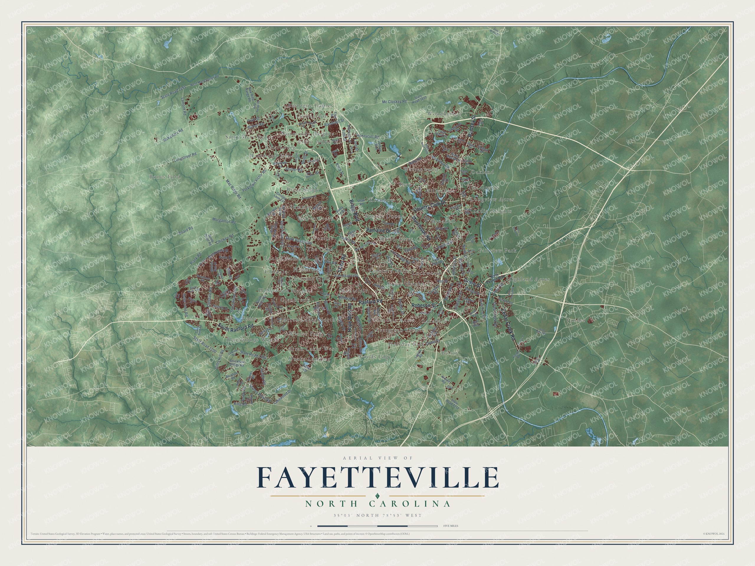
Fayetteville, North Carolina Map Art
Building by building, with labeled streets and shaded relief.
12" x 18" Archival Matte Print
A Map of Home. A Work of Art.
Explore Fayetteville, North Carolina from a whole new perspective. Created using aerial imagery and detailed geographic data, this map captures Fayetteville building by building, with labeled streets, familiar landmarks, and shaded topographical relief that highlights the natural contours of the landscape.
Combining modern data with the timeless character of a vintage atlas, this map is just as interesting up close as it is beautiful on the wall. Whether you grew up in Fayetteville, spent memorable years there, or call it home today, this unique map is a great way to celebrate a place that means something to you. Zoom in on the preview to look for your street, and then order a print to put your memories on the wall.
Three ways to hang it

Unframed archival matte, a black wood frame or a white wood frame.
Up close
Geography Worth Displaying
This map was created using accurate cartographic data and authoritative geographic sources, including the U.S. Geological Survey and the Census Bureau. The map brings together terrain, waterways, roads, and building detail. The majority of the streets are labeled, houses are accurately depicted, and the topography is derived from government sources. Combining local data with carefully composed color and shading leads to this beautifully detailed Fayetteville artwork for your wall.
Rather than simply showing street outlines, we’ve included as many of the street names as we could reasonably fit on the map while keeping their names legible. Zoom in on the high resolution preview to see exactly what’s on the map. We truly set out to create a statement piece for anyone who loves Fayetteville. So whether it’s for you, or a gift for someone you love, we hope this map of Fayetteville brings back fond memories.
Read the story behind this map of Fayetteville, North Carolina from 2026.

Find your street
Names on the Fayetteville map
Every name below is printed on this map. Look for your street, your school, the park where you played, or the pond down the road.
Places and landmarks50
- Bones Ford
- Woodbridge
- Ducks Landing
- Normandy Heights
- Hermitage
- Sadie Heights
- Vander
- Belair
- Bonnie Doone
- Arran Lakes North
- Shaws
- Hammond Hills
Show all 50 places
- Vanstory Hills
- Summer
- Fenix
- Oakland
- Fairview Park
- Evergreen Estates
- Glendale Acres
- Broad Acres
- Woods Edge
- Warrenwood
- Highland Acres
- Clifdale
- The Oaks
- Corregidor
- Hollywood Heights
- Savoy Heights
- Winter Park
- Kornbow
- Saint Mere Eglise
- Lakedale
- Loch Lommond
- Anzio Acres
- Bizza Ridge
- Holiday Park
- Montclair
- Hillendale
- Longview Acres
- Bluesprings Woods
- Bastogne Gables
- Glenbrook
- Chestnut Hills
- Arran Lakes West
- Lockwood
- Foxfire
- Cherbourg
- The Greens
- Beaver Creek
- Broadell
Streets and roads213
- Bragg Boulevard
- Murchison Road
- Raeford Road
- Ramsey Street
- Cedar Creek Road
- Skibo Road
- Hope Mills Road
- Pamalee Drive
- Country Club Drive
- South Raeford Road
- Robeson Street
- Grove Street
- Morganton Road
- State Road 1404
- Gruber Road
- Longstreet Road
- Honeycutt Road
- Chicken Road
- State Road 1403
- Yadkin Road
- Butner Road
- McKellars Road
- State Road 1104
- Reilly Street
- State Road 1100
- Cliffdale Road
- Mac Ridge Road
- Owen Drive
- State Road 1451
- Stoney Point Road
Show all 213 streets
- Rim Road
- Knox Street
- Lamont Road
- McArthur Road
- Mc Closkey Road
- Gillespie Street
- Hoke Loop Road
- Fifth Street
- Fort Bragg Road
- Dundle Road
- State Road 1402
- Lakewood Drive
- Gillis Hill Road
- Plank Road
- King Road
- Ireland Drive
- Board Road
- Randolph Street
- Dunn Road
- Deep Creek Road
- Hillsboro Street
- Brookshire Street
- Yorktown Victor Road
- Lane Street
- Poplar Drive
- Person Street
- North Street
- Winslow Street
- Hay Street
- Purdue Drive
- Pratt Street
- Ruby Road
- Belford Road
- Langdon Street
- Odom Drive
- Nix Road
- Avila Drive
- Gola Drive
- Street
- Lyon Road
- Jura Drive
- State Road 1400
- Rosehill Road
- Strickland Bridge Road
- West Manchester Road
- South Reilly Road
- Ardennes Road
- Bingham Drive
- Santa Fe Drive
- Southern Avenue
- Roxie Avenue
- Blackjack Street
- Shaw Road
- North Reilly Road
- Shawcroft Road
- Fisher Road
- Beaver Run Drive
- Decatur Drive
- New Rifle Range Road
- Ashton Road
- Braddy Road
- Stacy Weaver Drive
- Canopy Lane Extension
- State Road 1610
- Hilliard Drive
- Wayne Lane
- Airport Road
- Bomb Proof Road
- Dobson Drive
- Tryon Drive
- State Road 2212
- Clinton Road
- Beverly Drive
- Cain Road
- South King Street
- Landau Road
- Grimes Road
- Skye Drive
- Ann Street
- State Road 2672
- Law Road
- Scott Street
- Milford Road
- First Street
- Barefoot Road
- Hoffer Drive
- Parham Boulevard
- Wingate Road
- Siple Avenue
- Wildwood Drive
- Pearl Street
- Chilton Drive
- Amour Drive
- Adrian Drive
- Legion Road
- Conifer Drive
- Swan Island Court
- Louise Street
- Turnpike Road
- Mesa Drive
- Filter Plant Drive
- Our Street
- Greer Avenue
- Irwin Drive
- Quarry Drive
- Ferrell Drive
- Elvira Street
- Dairy Drive
- Fields Road
- Lynn Avenue
- Adair Street
- Belt Boulevard
- North Eastern Boulevard
- State Road 1600
- Village Drive
- State Road 1593
- Camden Road
- Sycamore Dairy Road
- School Road
- Century Circle
- Ellie Avenue
- Foxberry Road
- Rifle Range Road
- Evanston Street
- Bonanza Drive
- Fairfield Road
- Andover Road
- Sykes Pond Road
- Nessee Street
- English Saddle Drive
- Campbell Avenue
- Pelt Drive
- Buhman Road
- Berkshire Road
- Son Tay Road
- Friar Avenue
- Kinlaw Road
- Woodmark Road
- Treetop Drive
- Elm Street
- Plantation Road
- Torrey Drive
- Oates Drive
- Biltmore Drive
- Hewitt Drive
- Layton Drive
- Sharp Drive
- Tyler Drive
- Kara Court
- Old Street
- Zabitosky Road
- Graham Road
- State Road 2000
- Macomb Street
- Kedenburg Street
- Timbercroft Lane
- Third Street
- Inverness Drive
- Gooden Drive
- Seabrook Road
- Longleaf Drive
- North Plymouth Street
- Vandenberg Drive
- Fork Road
- Rayconda Place
- Brunswick Road
- Vestal Avenue
- Harlow Drive
- Ridgeway Drive
- Delaware Drive
- Lynhurst Drive
- Elliot Bridge Road
- Marsh Street
- Beta Street
- Division Place
- Loufield Drive
- Draw Bridge Lane
- Williams Road
- Lewis Street
- Neville Street
- Canopy Lane
- April Drive
- Zepher Road
Names are listed as they appear on the printed map. Zoom into the product photos to find them.
About Fayetteville, North Carolina
Fayetteville is a city of 208,501 people and the county seat of Cumberland County, on the Cape Fear River. Scots led by Colonel McAllister settled Campbelltown here in 1739, and its neat grid can still be traced near the river on the east side of town. Merchants in Wilmington backed a town on the Cape Fear because they feared frontier farmers would ship their goods down the Pee Dee River to Charleston instead.
Campbelton and its neighbor Cross Creek joined in 1783, and the combined town was incorporated as Fayetteville. The name honored the Marquis de Lafayette, the French hero who had helped the Americans in the Revolution, and no American city had been named for him before. In 1789 the town hosted the state convention that approved the U.S. Constitution, along with the legislative session that granted a charter to the University of North Carolina. It later lost the contest for the permanent capital to Raleigh.
“we will hold all those persons inimical to the liberty of the colonies, who shall refuse to subscribe to this Association”
- Rebuilt after 1831The Great Fire of 1831 burned hundreds of homes and businesses and the old State House, though no one died. The government was settled in Raleigh by then, so the town built the Market House on the State House site, finished in 1832, with a covered space for trade because every store had burned. It was a market until 1906 and town hall until 1907, joined the National Register in 1970, and is now a local history museum.
- Lafayette came in 1825On March 4 and 5, 1825, Lafayette stopped here during his tour of all the states. Of the towns named for him, it was the only one he saw in person. Crowds waited in mud and heavy rain to greet him, and the town gave him a formal dinner, a ball and several military displays.
- A preacher's church of 1796Henry Evans, a free Black shoemaker and licensed Methodist preacher, met white opposition when he began preaching to enslaved people here, but in time whites came to his services too. He is credited with building the town's first church, the African Meeting House, in 1796. Locals call him the "Father of Methodism," and Evans Metropolitan AME Zion Church carries his name.
- Sherman in March 1865On March 11, 1865, Confederate Lt. Gen. Wade Hampton's men surprised a Union cavalry patrol downtown, killing 11 soldiers and capturing a dozen. Gen. William T. Sherman's army of 60,000 still took the town. His troops wrecked the Confederate arsenal and the foundries, then tore apart the town's cotton factories and the newspaper offices of The Fayetteville Observer.
- Fort Bragg inside the cityWhen the city took in 85% of Fort Bragg in September 2008, its population climbed to 206,000. The post is home to the 82nd Airborne Division and the headquarters of the XVIII Airborne Corps.
Keep exploring North Carolina
Fayetteville is one of 952 North Carolina towns we've mapped. Every dot on the map is a print of its own.
The search covers every state, North Carolina first.
Near Fayetteville
Order 2 or more town maps and save 10%. Shown in the size and finish you picked above, so they hang as a set.
- Spring Lake 12" x 18" / Archival Matte Print $39.99
- Hope Mills 12" x 18" / Archival Matte Print $39.99
- Stoney Point 12" x 18" / Archival Matte Print $39.99


More maps nearby: Rockfish, Overhills, Eastover, Vander and Sandy Grove.
The art of mapping a place
How This Map Was Made
Real places. Remarkable detail. Discover the layers that turn geographic data into a map of home.

The view from above
Aerial imagery reveals the character of the land: woodland, open fields, and the patterns of a place.

The shape of the land
Elevation data brings hills, valleys, and subtle changes in the landscape into view.

The details of home
Roads, waterways, and building footprints come together to make the map feel unmistakably local.

Geography becomes art
Considered color, shading, and typography bring the layers together in a map made for your wall.


Process illustrated with Mendon, Massachusetts. Aerial imagery: USDA NAIP. Terrain: USGS 3D Elevation Program. Map details and finished artwork: KNOWOL.
The Details
About This Print
Choose an archival matte print, or a black or white Ayous wood frame. The archival matte print is unframed.
Select your size and finish above to see the matching product image and price.
Materials & Craftsmanship
A contemporary map with the character of a classic atlas, printed on archival matte paper. Optional frames are made from Ayous wood.
Your printed map does not include the watermark shown in the full-map preview.
Shipping & Delivery
Free shipping within the United States. Every print is made to order in the USA.
Buying a gift? Add a note in your cart and we'll include it. We never put prices in the package.
Prints ship within 2 to 3 business days. Allow 7 to 10 days total from ordering for delivery. Timing may vary during holidays or periods of high order volume.
Read our shipping policy.
Returns and damaged prints
Each print is made to order. Change-of-mind refunds are not available after production.
If your print arrives damaged, misprinted or incorrect, contact support@knowol.com within 30 days of receiving it. Include your order number, photos and a description of the issue.
Read our full refund and replacement policy. For questions about your order, email support@knowol.com.