
Search for another town


Free U.S. delivery 7 to 10 days after you order
Goldsboro, North Carolina Map Art
Building by building, with labeled streets and shaded relief.
12" x 18" Archival Matte Print
A Map of Home. A Work of Art.
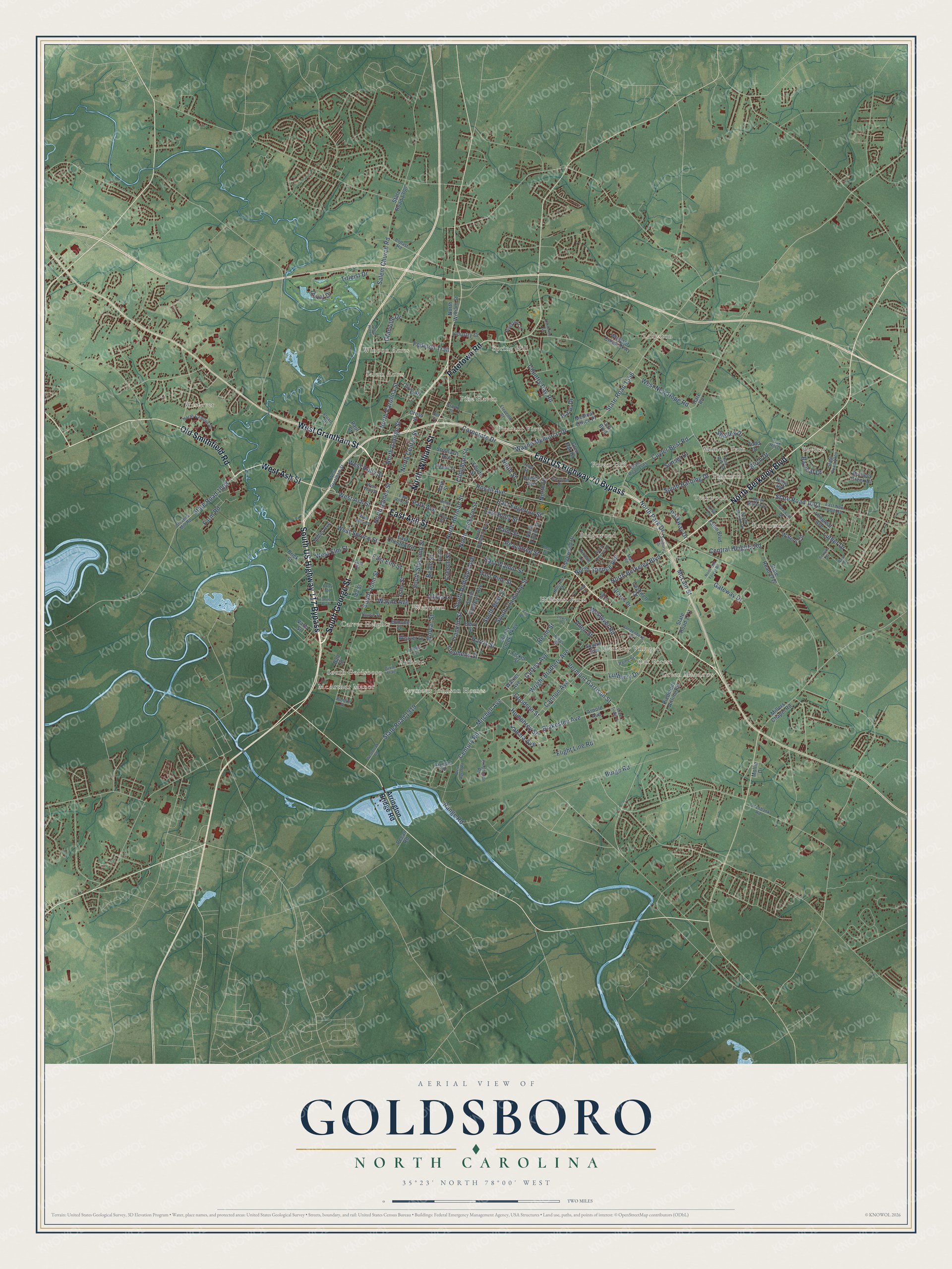
Explore Goldsboro, North Carolina from a whole new perspective. Created using aerial imagery and detailed geographic data, this map captures Goldsboro building by building, with labeled streets, familiar landmarks, and shaded topographical relief that highlights the natural contours of the landscape.
Combining modern data with the timeless character of a vintage atlas, this map is just as interesting up close as it is beautiful on the wall. Whether you grew up in Goldsboro, spent memorable years there, or call it home today, this unique map is a great way to celebrate a place that means something to you. Zoom in on the preview to look for your street, and then order a print to put your memories on the wall.
Three ways to hang it

Unframed archival matte, a black wood frame or a white wood frame.
Up close
Geography Worth Displaying
This map was created using accurate cartographic data and authoritative geographic sources, including the U.S. Geological Survey and the Census Bureau. The map brings together terrain, waterways, roads, and building detail. The majority of the streets are labeled, houses are accurately depicted, and the topography is derived from government sources. Combining local data with carefully composed color and shading leads to this beautifully detailed Goldsboro artwork for your wall.
Rather than simply showing street outlines, we’ve included as many of the street names as we could reasonably fit on the map while keeping their names legible. Zoom in on the high resolution preview to see exactly what’s on the map. We truly set out to create a statement piece for anyone who loves Goldsboro. So whether it’s for you, or a gift for someone you love, we hope this map of Goldsboro brings back fond memories.
Read the story behind this map of Goldsboro, North Carolina from 2026.

Find your street
Names on the Goldsboro map
Every name below is printed on this map. Look for your street, your school, the park where you played, or the pond down the road.
Places and landmarks24
- Bayleaf
- Spring Hill
- Green Meadows
- McArthur Manor
- Westover
- Teakwood
- Ridgewood
- Salem Acres
- Langston
- Hillcrest Farm
- Webtown
- Pleasant View
Show all 24 places
- Seymour Johnson Homes
- Carver Heights
- Mimosa Park
- Forest Hill
- Berkeley Village
- Ravenwood
- Pine Haven
- Pinemont
- Airboro
- Winbon Acres
- Oak Forest
- South Goldsboro
Streets and roads194
- East Ash Street
- North Berkeley Boulevard
- West Ash Street
- Old Smithfield Road
- West Grantham Street
- South George Street
- South US Highway 117 Bypass
- East US Highway 70 Bypass
- North William Street
- Patetown Road
- Curtiss Avenue
- Jabara Avenue
- Humphrey Street
- Goodson Street
- Mitchell Avenue
- Westover Road
- Allen Street
- Wright Brothers Avenue
- Ream Street
- Wayne Memorial Drive
- North Center Street
- North Carolina Street
- State Road 1556
- Park Avenue
- Corporate Drive
- South Slocumb Street
- Century Road
- Country Day Road
- South Best Street
- Vermont Garrison Street
Show all 194 streets
- North Herman Street
- South Audubon Avenue
- State Road 1003
- Royall Avenue
- Burge Road
- East Elm Street
- West New Hope Road
- Central Heights Road
- Salem Church Road
- South John Street
- East Walnut Street
- East Holly Street
- McLain Street
- Cuyler Best Road
- North Spence Avenue
- East Pine Street
- Blakeslee Avenue
- Range Road
- North George Street
- Titleist Drive
- Harris Street
- Peachtree Street
- North James Street
- Olivia Lane
- State Road 1919
- South Claiborne Street
- South Harding Drive
- East Edgerton Street
- Cannon Avenue
- State Road 1008
- Fedelon Trail
- Wayne Avenue
- West Elm Street
- Shelley Drive
- Poplar Street
- Luther Drive
- Franklin Street
- West Holly Street
- North Jackson Street
- Bayleaf Drive
- Clingman Street
- Gateway Drive
- North Drive
- Farm Road
- Parkway Drive
- Palm Street
- Stephens Street
- West Spruce Street
- North Park Drive
- Sunset Drive
- Flight Line Road
- Birch Drive
- Isaac Drive
- Ninth Street
- Lufberry Drive
- Granville Drive
- Isler Street
- Duval Drive
- Creech Street
- Beale Street
- Arrington Bridge Road
- Paul Street
- Glen Oak Drive
- State Road 1711
- Cashwell Drive
- South Andrews Avenue
- State Road 1300
- Arnold Avenue
- Hunters Creek Drive
- Piedmont Airline Road
- Squire Avenue
- Millers Chapel Road
- North Taylor Street
- East Chestnut Street
- Windsor Creek Parkway
- Berry Street
- Ridgewood Drive
- Waters Circle
- Bunche Drive
- State Road 1712
- Stoney Creek Parkway
- Todd Drive
- Stronach Avenue
- Banks Avenue
- Industry Court
- Longleaf Avenue
- Fallin Boulevard
- Fourth Street
- Walker Avenue
- Graves Drive
- Vann Street
- Brick Street
- Weaver Drive
- Fickel Street
- Medical Office Place
- Miller Avenue
- Holly Road
- Cross Street
- Cox Boulevard
- Olive Street
- Ball Street
- Mollie Drive
- Hare Road
- Pecan Road
- Bain Street
- Ida Street
- Vandenberg Street
- Daymond Road
- East Vine Street
- State Road 1709
- Eleventh Street
- East New Hope Road
- State Road 1565
- Stevens Mill Road
- Dixie Trail
- North Audubon Avenue
- Hillcrest Drive
- North Marion Drive
- Biggs Street
- Kingston Circle
- North Campus Drive
- Oak Hill Drive
- South Marion Drive
- Propulsion Road
- Lee Drive
- Second Street
- Paine Street
- Cardinal Drive
- West Vine Street
- Gra-Lan Drive
- Ditchbank Road
- Lisa Lane
- Mall Road
- Belfast Road
- House Street
- Kay Dee Street
- Hilldale Lane
- Benton Street
- Pou Street
- Frank Street
- Stuart Street
- Cella Street
- Cola Drive
- South Tinker Street
- Beech Street
- North Oak Forest Road
- Westbrook Road
- Sunburst Drive
- Rose Street
- Lowry Drive
- West Walnut Street
- North Hillcrest Drive
- Alert Apron Road
- Carver Boulevard
- Neil Street
- Catherine Street
- Bright Street
- Hodges Avenue
- Wood Street
- Forsyth Street
- Salem Hill Lane
- Oxley Avenue
- Elm Place
- Ivey Court
Names are listed as they appear on the printed map. Zoom into the product photos to find them.
About Goldsboro, North Carolina
Goldsboro is a city of 33,657 people and the county seat of Wayne County. The Neuse River runs along its south side and the Little River along its west. When Wayne County was formed around 1787, a town called Waynesborough grew up around its courthouse beside the Neuse, and William Whitfield III and his son were named to lay it out and build it.
Waynesborough kept growing until the Wilmington and Weldon Railroad was finished in the early 1840s. A hotel stood where the tracks crossed New Bern Road, and once passenger trains stopped there, people began moving to the new settlement. It was called Goldsborough's Junction, for Major Matthew T. Goldsborough, an engineer on the line, and later just Goldsborough. In 1847 it was incorporated, and Wayne County voters made it the county seat. Local legend says its backers put moonshine in the town well to win votes. The spelling became Goldsboro in 1869.
- Burning the railroad bridgeThe rail junction made the town a base for Confederate troops and supplies, and it held hospitals for the wounded. On December 17, 1862, Union General John Foster's troops overran the few defenders and burned the Wilmington and Weldon Railroad bridge to cut the supply line from the port of Wilmington. The bridge was rebuilt within weeks.
- Sherman's armies in 1865Sherman's armies took Goldsboro in March 1865. More than 100,000 Union soldiers stayed in the town for three weeks.
- An air base since 1942North Carolina's members of Congress won the base during World War II. It opened on the edge of Goldsboro in April 1942 as Seymour Johnson Field, an Army Air Forces post, and the city's people and businesses grew with it. It became Seymour Johnson Air Force Base in 1947, after the Air Force became its own service.
- Two bombs that didn't go offIn 1961 a B-52 broke apart in the air. After the crew bailed out, two 3.8 megaton Mark 39 hydrogen bombs fell on Faro, 12 miles north of Goldsboro. Neither exploded. Both were mostly recovered, but a uranium-holding piece sank deep into swampy ground, so the Air Force bought the land to stop any digging. In 2013 it came out that a single low-voltage switch had kept one bomb from going off.
Keep exploring North Carolina
Goldsboro is one of 952 North Carolina towns we've mapped. Every dot on the map is a print of its own.
The search covers every state, North Carolina first.
Near Goldsboro
Order 2 or more town maps and save 10%. Shown in the size and finish you picked above, so they hang as a set.
- Elroy 12" x 18" / Archival Matte Print $39.99
- New Hope 12" x 18" / Archival Matte Print $39.99
- Rosewood 12" x 18" / Archival Matte Print $39.99


More maps nearby: Mar-Mac, Brogden, Walnut Creek, Pikeville and Dudley.
The art of mapping a place
How This Map Was Made
Real places. Remarkable detail. Discover the layers that turn geographic data into a map of home.

The view from above
Aerial imagery reveals the character of the land: woodland, open fields, and the patterns of a place.

The shape of the land
Elevation data brings hills, valleys, and subtle changes in the landscape into view.

The details of home
Roads, waterways, and building footprints come together to make the map feel unmistakably local.

Geography becomes art
Considered color, shading, and typography bring the layers together in a map made for your wall.


Process illustrated with Mendon, Massachusetts. Aerial imagery: USDA NAIP. Terrain: USGS 3D Elevation Program. Map details and finished artwork: KNOWOL.
The Details
About This Print
Choose an archival matte print, or a black or white Ayous wood frame. The archival matte print is unframed.
Select your size and finish above to see the matching product image and price.
Materials & Craftsmanship
A contemporary map with the character of a classic atlas, printed on archival matte paper. Optional frames are made from Ayous wood.
Your printed map does not include the watermark shown in the full-map preview.
Shipping & Delivery
Free shipping within the United States. Every print is made to order in the USA.
Buying a gift? Add a note in your cart and we'll include it. We never put prices in the package.
Prints ship within 2 to 3 business days. Allow 7 to 10 days total from ordering for delivery. Timing may vary during holidays or periods of high order volume.
Read our shipping policy.
Returns and damaged prints
Each print is made to order. Change-of-mind refunds are not available after production.
If your print arrives damaged, misprinted or incorrect, contact support@knowol.com within 30 days of receiving it. Include your order number, photos and a description of the issue.
Read our full refund and replacement policy. For questions about your order, email support@knowol.com.