
Search for another town


Free U.S. delivery 7 to 10 days after you order
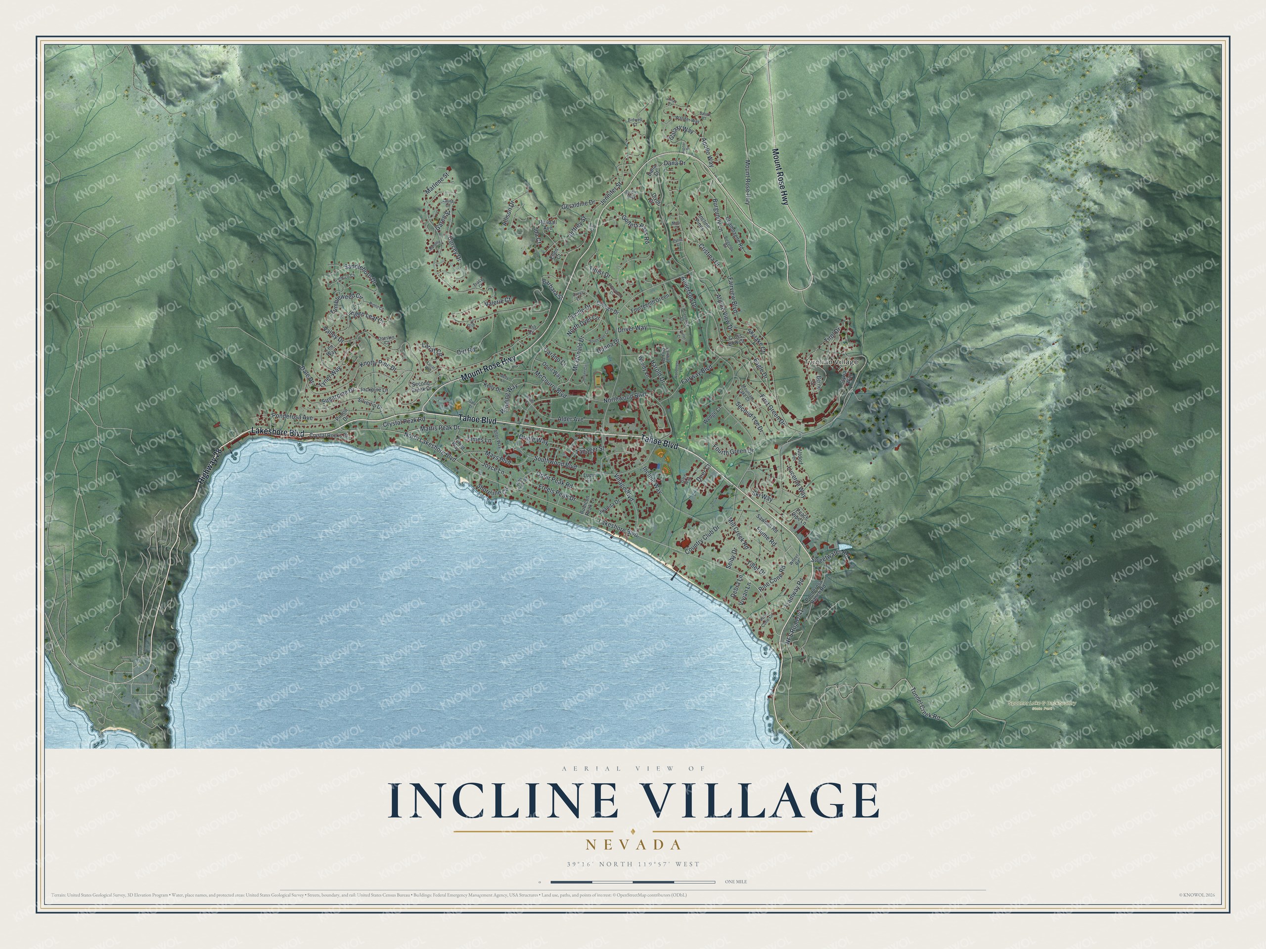
Incline Village, Nevada Map Art
Building by building, with labeled streets and shaded relief.
12" x 18" Archival Matte Print
A Map of Home. A Work of Art.
Explore Incline Village, Nevada from a whole new perspective. Created using aerial imagery and detailed geographic data, this map captures Incline Village building by building, with labeled streets, familiar landmarks, and shaded topographical relief that highlights the natural contours of the landscape.
Combining modern data with the timeless character of a vintage atlas, this map is just as interesting up close as it is beautiful on the wall. Whether you grew up in Incline Village, spent memorable years there, or call it home today, this unique map is a great way to celebrate a place that means something to you. Zoom in on the preview to look for your street, and then order a print to put your memories on the wall.
Three ways to hang it

Unframed archival matte, a black wood frame or a white wood frame.
Up close
Geography Worth Displaying
This map was created using accurate cartographic data and authoritative geographic sources, including the U.S. Geological Survey and the Census Bureau. The map brings together terrain, waterways, roads, and building detail. The majority of the streets are labeled, houses are accurately depicted, and the topography is derived from government sources. Combining local data with carefully composed color and shading leads to this beautifully detailed Incline Village artwork for your wall.
Rather than simply showing street outlines, we’ve included as many of the street names as we could reasonably fit on the map while keeping their names legible. Zoom in on the high resolution preview to see exactly what’s on the map. We truly set out to create a statement piece for anyone who loves Incline Village. So whether it’s for you, or a gift for someone you love, we hope this map of Incline Village brings back fond memories.
Read the story behind this map of Incline Village, Nevada from 2026.

Find your street
Names on the Incline Village map
Every name below is printed on this map. Look for your street, your school, the park where you played, or the pond down the road.
Places and landmarks2
- Tyrolian Village
- Spooner Lake & Backcountry State Park
Streets and roads147
- Lakeshore Boulevard
- Highway 28
- Tahoe Boulevard
- Mount Rose Highway
- Village Boulevard
- Ski Way
- Golfers Pass Road
- Tirol Drive
- Tunnel Creek Road
- Eagle Drive
- Tyner Way
- Fairview Boulevard
- NFS Road 041
- Sugarpine Drive
- Ophir Peak Road
- Country Club Drive
- Jennifer Street
- Driver Way
- Northwood Boulevard
- Southwood Boulevard
- Incline Way
- Apollo Way
- Dorcey Drive
- Knotty Pine Drive
- Alpine View Drive
- Ponderosa Avenue
- Saddlehorn Drive
- Tumbleweed Circle
- Winding Way
- Geraldine Drive
Show all 147 streets
- First Green Drive
- Mc Donald Drive
- Lucerne Way
- Lucille Drive
- Second Tee Drive
- Tramway Road
- Dirt Road
- Martis Peak Drive
- Freels Peak Drive
- Mays Boulevard
- Dale Drive
- McCourry Boulevard
- Burgundy Lane
- Oriole Way
- Fairway Boulevard
- Alder Avenue
- Mill Creek Road
- Cristina Drive
- Donna Drive
- Harold Drive
- North Lakeshore Boulevard
- Crystal Peak Road
- Lariat Circle
- Marlene Street
- Pine Cone Road
- Tiller Drive
- Fourth Green Drive
- Titlist Drive
- North Dyer Circle
- Skylake Court
- Fallen Leaf Court
- Joyce Lane
- Jeffrey Street
- Anderson Drive
- Allison Drive
- Flume Road
- Shoreline Circle
- Tanager Street
- Sweetwater Road
- Galaxy Way
- James Lane
- Carano Court
- Vivian Lane
- Valley Drive
- Selby Drive
- Valerie Court
- Barbara Street
- Dana Drive
- Debra Lane
- Garen Street
- Deer Court
- Ida Court
- Crystal Rocks Drive
- Jackpine Lane
- Styria Way
- Second Creek Drive
- Silvertip Drive
- Incline Pines
- Randall Avenue
- Fourteenth Green
- Champagne Road
- College Drive
- Ponderosa Ranch Road
- Altdorf Terrace
- Kelly Drive
- Juanita Drive
- Sawmill Road
- Oneil Way
- Wendy Lane
- David Way
- Cross Bow Court
- Lupin Lane
- Rubicon Peak Lane
- Wedge Court
- Len Way
- Pinion Drive
- Peace Pipe Lane
- Divot Court
- Berne Court
- Ellen Court
- Dana Court
- Jill Court
- Crest Lane
- Glen Way
- Pine Cone Circle
- Mountain Lake Court
- Fairway Park Drive
- Glenrock Court
- Allen Way
- Wander Way
- Birdie Way
- Pinto Court
- Chico Court
- Doeskin Court
- Jobs Peak Road
- Bidwell Court
- Wheel Road
- Tracy Court
- Laura Court
- Fay Street
- Rosewood Circle
- Burgundy Road
- Jensen Circle
- South Dyer Circle
- Woodmere Lane
- Jupiter Drive
- Betty Lane
- Saturn Court
- Dorothy Court
- Putter Court
- Lunar Court
- Lariat Way
- Pyrite Court
- Alder Court
- Gary Court
- Mica Court
- Toni Court
Names are listed as they appear on the printed map. Zoom into the product photos to find them.
About Incline Village, Nevada
Incline Village is a community of 9,462 people in Washoe County, on the north shore of Lake Tahoe, with its town center 6,350 feet above sea level. It began as a logging settlement of the Sierra Nevada Wood and Lumber Company, which cut timber around the lake because the silver mines of the Comstock Lode in Virginia City needed huge amounts of wood. The settlement was established in 1882, and a post office opened on February 7, 1884.
The lumber camp was called Incline, after the company's cable railway that climbed the mountain behind the sawmill. Its village had a boardinghouse, a store, a stable and several cabins. When logging stopped, the camp emptied, and Incline had become a ghost town before 1897 was over. When a new resort community grew up here in the 1960s, it took the old name and became Incline Village.
- The Great Incline of 1880Finished in 1880, the company's steam-powered cable railway ran 4,000 feet up the slope, lifting cordwood and lumber 1,400 vertical feet from the mill on today's Mill Creek. At the top, the wood was tipped into a wooden V flume that sent it down to Washoe Valley, and wagons hauled it from there to the Comstock mines. A good day moved as many as 300 cords. The site is State Historical Marker No. 246.
- A ski resort the town ownsDiamond Peak Ski Resort belongs to the community itself. Each winter the Ullr Festival raises money for the Diamond Peak Ski Team. The Incline Village General Improvement District, which runs the resort, also handles trash, water, sewer and recreation for residents of Incline Village and neighboring Crystal Bay.
- Lake Tahoe's science museumThe UC Davis Tahoe Environmental Research Center runs environmental research laboratories in Incline Village, along with the only science museum anywhere on Lake Tahoe. Sierra Nevada University's former campus is also here; the school now goes by University of Nevada, Reno at Lake Tahoe.
Keep exploring Nevada
Incline Village is one of 152 Nevada towns we've mapped. Every dot on the map is a print of its own.
The search covers every state, Nevada first.
Near Incline Village
Order 2 or more town maps and save 10%. Shown in the size and finish you picked above, so they hang as a set.
- Crystal Bay 12" x 18" / Archival Matte Print $39.99
- Washoe Valley 12" x 18" / Archival Matte Print $39.99
- Pleasant Valley 12" x 18" / Archival Matte Print $39.99


More maps nearby: Glenbrook, Carson City, Logan Creek, Indian Hills and Lakeridge.
The art of mapping a place
How This Map Was Made
Real places. Remarkable detail. Discover the layers that turn geographic data into a map of home.

The view from above
Aerial imagery reveals the character of the land: woodland, open fields, and the patterns of a place.

The shape of the land
Elevation data brings hills, valleys, and subtle changes in the landscape into view.

The details of home
Roads, waterways, and building footprints come together to make the map feel unmistakably local.

Geography becomes art
Considered color, shading, and typography bring the layers together in a map made for your wall.


Process illustrated with Mendon, Massachusetts. Aerial imagery: USDA NAIP. Terrain: USGS 3D Elevation Program. Map details and finished artwork: KNOWOL.
The Details
About This Print
Choose an archival matte print, or a black or white Ayous wood frame. The archival matte print is unframed.
Select your size and finish above to see the matching product image and price.
Materials & Craftsmanship
A contemporary map with the character of a classic atlas, printed on archival matte paper. Optional frames are made from Ayous wood.
Your printed map does not include the watermark shown in the full-map preview.
Shipping & Delivery
Free shipping within the United States. Every print is made to order in the USA.
Buying a gift? Add a note in your cart and we'll include it. We never put prices in the package.
Prints ship within 2 to 3 business days. Allow 7 to 10 days total from ordering for delivery. Timing may vary during holidays or periods of high order volume.
Read our shipping policy.
Returns and damaged prints
Each print is made to order. Change-of-mind refunds are not available after production.
If your print arrives damaged, misprinted or incorrect, contact support@knowol.com within 30 days of receiving it. Include your order number, photos and a description of the issue.
Read our full refund and replacement policy. For questions about your order, email support@knowol.com.