


Search for another town


Free U.S. delivery 7 to 10 days after you order
Iowa City, Iowa Map Art
Building by building, with labeled streets and shaded relief.
12" x 18" Archival Matte Print
A Map of Home. A Work of Art.
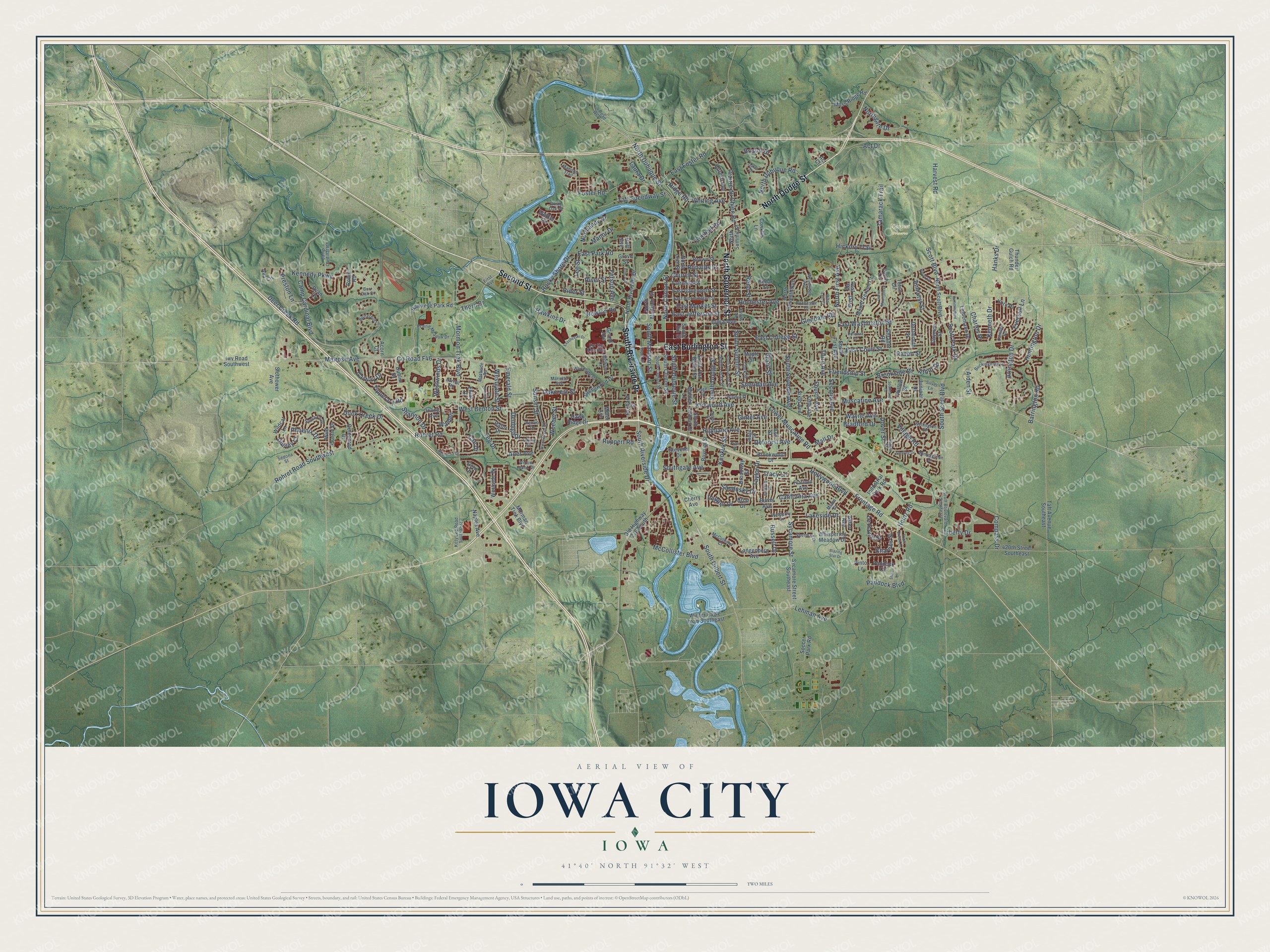
Explore Iowa City, Iowa from a whole new perspective. Created using aerial imagery and detailed geographic data, this map captures Iowa City building by building, with labeled streets, familiar landmarks, and shaded topographical relief that highlights the natural contours of the landscape.
Combining modern data with the timeless character of a vintage atlas, this map is just as interesting up close as it is beautiful on the wall. Whether you grew up in Iowa City, spent memorable years there, or call it home today, this unique map is a great way to celebrate a place that means something to you. Zoom in on the preview to look for your street, and then order a print to put your memories on the wall.
Three ways to hang it

Unframed archival matte, a black wood frame or a white wood frame.
Up close
Geography Worth Displaying
This map was created using accurate cartographic data and authoritative geographic sources, including the U.S. Geological Survey and the Census Bureau. The map brings together terrain, waterways, roads, and building detail. The majority of the streets are labeled, houses are accurately depicted, and the topography is derived from government sources. Combining local data with carefully composed color and shading leads to this beautifully detailed Iowa City artwork for your wall.
Rather than simply showing street outlines, we’ve included as many of the street names as we could reasonably fit on the map while keeping their names legible. Zoom in on the high resolution preview to see exactly what’s on the map. We truly set out to create a statement piece for anyone who loves Iowa City. So whether it’s for you, or a gift for someone you love, we hope this map of Iowa City brings back fond memories.
Read the story behind this map of Iowa City, Iowa from 2026.

Find your street
Names on the Iowa City map
Every name below is printed on this map. Look for your street, your school, the park where you played, or the pond down the road.
Places and landmarks2
- City Park
- Harvest Preserve
Streets and roads276
- North Dodge Street
- Second Street
- South Riverside Drive
- East Burlington Street
- North Governor Street
- County Road F46
- Mormon Trek Boulevard
- Muscatine Avenue
- Kirkwood Avenue
- East Washington Street
- South Gilbert Street
- Iowa Avenue
- North Clinton Street
- Kennedy Parkway
- Church Street
- Lower Muscatine Road
- Rochester Avenue
- Rohret Road
- Melrose Avenue
- East Court Street
- North Dubuque Street
- Camp Cardinal Boulevard
- Scott Boulevard
- West Benton Street
- Friendship Street
- South Scott Boulevard
- Foster Road
- Hollywood Boulevard
- Heinz Road
- East College Street
Show all 276 streets
- McCollister Boulevard
- Sycamore Street
- Act Drive
- Arlington Drive
- East Jefferson Street
- Highland Avenue
- Harvest Road
- North Dubuque Road
- Village Road
- North First Avenue
- East Park Road
- Hawkins Drive
- Second Avenue
- Newton Road
- Dover Street
- Deer Creek Road
- Prairie du Chien Road
- East Market Street
- Third Avenue
- South Seventh Avenue
- Keokuk Street
- Fourth Avenue
- Barrington Road
- Lakeside Drive
- River Street
- South Dubuque Street
- Sandusky Drive
- Sunset Street
- Russell Drive
- Kimball Road
- South Summit Street
- East Foster Road
- Rohret Road Southwest
- Northgate Drive
- Ruppert Road
- Huntington Drive
- California Avenue
- Oakcrest Street
- Glendale Road
- Duck Creek Drive
- Lehman Avenue
- Ronalds Street
- Westwinds Drive
- Amhurst Street
- Teg Drive
- Scott Park Drive
- Preston Lane
- Normandy Drive
- Tamarack Trail
- South Dodge Street
- Wayne Avenue
- Deforest Avenue
- Bristol Drive
- Southgate Avenue
- Raven Street
- Tipperary Road
- Ferson Avenue
- Taft Speedway Street
- Chartres Street
- Hickory Trail
- Denbigh Drive
- Galway Drive
- Ridge Road
- Sheridan Avenue
- South Madison Street
- Compass Drive
- Brookside Drive
- Rocky Shore Drive
- Pepper Drive
- Phoenix Drive
- Kenneth Drive
- Laura Drive
- Taylor Drive
- Shannon Drive
- Ginter Avenue
- Westgate Street
- Emerald Street
- Bradford Drive
- Frontage Road
- Le Havre Street
- Paddock Boulevard
- Weeber Street
- Whiting Avenue
- Eversull Lane
- Charles Drive
- Post
- Manor Drive
- Mall Drive
- Arbor Drive
- Lee Street
- Reno Street
- Thorn Drive
- Tracy Lane
- Dunley Court
- Grant Street
- Walden
- Aiden Street
- Liberty Drive
- Cae Drive
- Rider Street
- Hanks Drive
- Aber Avenue
- South Clinton Street
- Morman Trek Boulevard
- Grand Avenue
- Old Highway 218 South
- North Riverside Drive
- Hawkeye Park Road
- Sycamore Street Southeast
- South First Avenue
- Taft Avenue Southeast
- East Davenport Street
- Soccer Park Road
- Fairchild Street
- South Van Buren Street
- Westside Drive
- Paddock Circle
- 420th Street Southeast
- North Linn Street
- Wild Prairie Drive
- Langenberg Avenue
- Brown Street
- Whispering Meadow Drive
- Winter Eagle Road Southeast
- Broadway Street
- North Seventh Avenue
- Fifth Avenue
- North Scott Boulevard
- South Linn Street
- Iwv Road Southwest
- Ryan Court
- South Gilbert Court
- Industrial Park Road
- Lindemann Drive
- Mount Vernon Drive
- Hawk Ridge Drive
- Moss Ridge Road
- Greenwood Drive
- North Summit Street
- Stevens Drive
- Goldenrod Drive
- Buresh Avenue
- Boyrum Street
- Post Road
- Burns Avenue
- Brookwood Drive
- Walker Circle
- Maiden Lane
- Irving Avenue
- Ash Street
- Naples Avenue
- North Madison Street
- Slothower Avenue
- Hafor Drive
- Wildcat Lane
- Briar Drive
- Dartmouth Street
- Conklin Lane
- Orchard Street
- Juniper Drive
- Ava Circle
- Miller Avenue
- Dublin Drive
- Willow Street
- Shrader Road
- Robin Road
- York Place
- Gryn Drive
- Thunder Gulch Road
- Sixth Avenue
- Cherry Avenue
- Flatiron Avenue
- Cayman Street
- Grove Street
- Aster Avenue
- Cedar Street
- Larch Lane
- Acorn Court
- Pinto Lane
- Maple Street
- Elliot Court
- Teton Circle
- Act Circle
- Holt Avenue
- South Capitol Street
- First Avenue
- Front Street
- Wintergreen Drive
- Silver Lane
- East Bloomington Street
- Camp Cardinal Road
- South Lucas Street
- Scott Boulevard Southeast
- Buckingham Lane
- Sherman Drive
- Prairie Meadow Drive
- Clark Street
- Woodside Drive
- Camden Road
- Woodridge Avenue
- Butternut Lane
- Sedona Street
- Walnut Street
- Wellington Drive
- Manitou Trail
- Santa Fe Drive
- Kitty Lee Road Southwest
- Penfro Drive
- Rochester Court
- Bartelt Road
- Page Street
- Miami Drive
- County Road W66
- Ealing Drive
- Ridge Street
- Esther Street
- Melrose Court
- McCollister Court
- Wetherby Drive
- Macbride Road
- For the Kids Way
- Marietta Avenue
- Willow Creek Drive
- Diana Street
- White Oak Place
- Evans Street
- Burr Oak Court
- Rita Lyn Court
- Oakes Drive
- Wylde Green Road
- Green Mountain Drive
- South Governor Street
- Evashevski Drive
- Plum Street
- Blazing Star Drive
- Keswick Drive
- Bancroft Drive
- Rushmore Drive
- Hummingbird Lane
- Potomac Drive
- Sterling Drive
- Triple Crown Lane
- Southlawn Drive
- Shire Lane
- Heron Circle
- Ellis Avenue
Names are listed as they appear on the printed map. Zoom into the product photos to find them.
About Iowa City, Iowa
Iowa City is Johnson County's largest city and county seat, with 74,828 residents recorded in the 2020 census. Planned in 1839 as Iowa Territory's new capital, it later became Iowa's first state capital and is now home to the University of Iowa. The Old Capitol survives as a museum and National Historic Landmark on the university campus.
- A Capital CityIowa City served as the territorial capital from 1841 to 1846 and as the state capital from 1846 to 1857.
- Old CapitolThe former seat of government is now a museum and National Historic Landmark on the University of Iowa campus.
- Oakland CemeteryDeeded to Iowa City residents in 1843, Oakland Cemetery later expanded to 40 acres.
- Record FloodIn June 2008, the Iowa River reached a record 30.46 feet, and 19 university buildings sustained water damage.
- A Direct TornadoAn EF2 tornado struck Iowa City on April 13, 2006, damaging more than 50 properties but causing no reported deaths.
Keep exploring Iowa
Iowa City is one of 1,038 Iowa towns we've mapped. Every dot on the map is a print of its own.
The search covers every state, Iowa first.
Near Iowa City
Order 2 or more town maps and save 10%. Shown in the size and finish you picked above, so they hang as a set.
- University Heights 12" x 18" / Archival Matte Print $39.99
- Coralville 12" x 18" / Archival Matte Print $39.99
- Hills 12" x 18" / Archival Matte Print $39.99

More maps nearby: Tiffin, North Liberty, West Branch, Downey and Solon.
The art of mapping a place
How This Map Was Made
Real places. Remarkable detail. Discover the layers that turn geographic data into a map of home.

The view from above
Aerial imagery reveals the character of the land: woodland, open fields, and the patterns of a place.

The shape of the land
Elevation data brings hills, valleys, and subtle changes in the landscape into view.

The details of home
Roads, waterways, and building footprints come together to make the map feel unmistakably local.

Geography becomes art
Considered color, shading, and typography bring the layers together in a map made for your wall.


Process illustrated with Mendon, Massachusetts. Aerial imagery: USDA NAIP. Terrain: USGS 3D Elevation Program. Map details and finished artwork: KNOWOL.
The Details
About This Print
Choose an archival matte print, or a black or white Ayous wood frame. The archival matte print is unframed.
Select your size and finish above to see the matching product image and price.
Materials & Craftsmanship
A contemporary map with the character of a classic atlas, printed on archival matte paper. Optional frames are made from Ayous wood.
Your printed map does not include the watermark shown in the full-map preview.
Shipping & Delivery
Free shipping within the United States. Every print is made to order in the USA.
Buying a gift? Add a note in your cart and we'll include it. We never put prices in the package.
Prints ship within 2 to 3 business days. Allow 7 to 10 days total from ordering for delivery. Timing may vary during holidays or periods of high order volume.
Read our shipping policy.
Returns and damaged prints
Each print is made to order. Change-of-mind refunds are not available after production.
If your print arrives damaged, misprinted or incorrect, contact support@knowol.com within 30 days of receiving it. Include your order number, photos and a description of the issue.
Read our full refund and replacement policy. For questions about your order, email support@knowol.com.