


Search for another town


Free U.S. delivery 7 to 10 days after you order
La Plata, Maryland Map Art
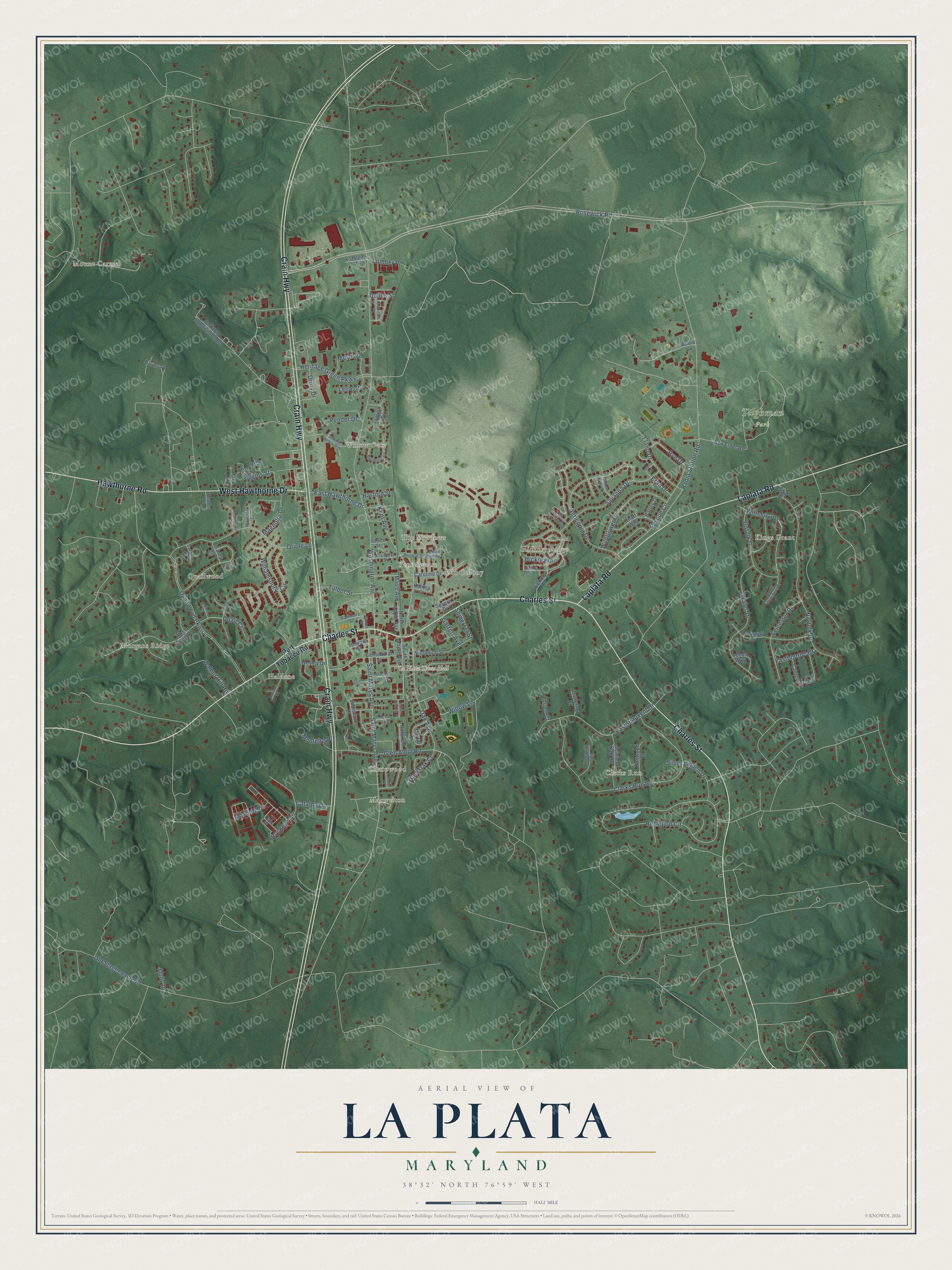
Building by building, with labeled streets and shaded relief.
12" x 18" Archival Matte Print
A Map of Home. A Work of Art.
Explore La Plata, Maryland from a whole new perspective. Created using aerial imagery and detailed geographic data, this map captures La Plata building by building, with labeled streets, familiar landmarks, and shaded topographical relief that highlights the natural contours of the landscape.
Combining modern data with the timeless character of a vintage atlas, this map is just as interesting up close as it is beautiful on the wall. Whether you grew up in La Plata, spent memorable years there, or call it home today, this unique map is a great way to celebrate a place that means something to you. Zoom in on the preview to look for your street, and then order a print to put your memories on the wall.
Three ways to hang it

Unframed archival matte, a black wood frame or a white wood frame.
Up close
Geography Worth Displaying
This map was created using accurate cartographic data and authoritative geographic sources, including the U.S. Geological Survey and the Census Bureau. The map brings together terrain, waterways, roads, and building detail. The majority of the streets are labeled, houses are accurately depicted, and the topography is derived from government sources. Combining local data with carefully composed color and shading leads to this beautifully detailed La Plata artwork for your wall.
Rather than simply showing street outlines, we’ve included as many of the street names as we could reasonably fit on the map while keeping their names legible. Zoom in on the high resolution preview to see exactly what’s on the map. We truly set out to create a statement piece for anyone who loves La Plata. So whether it’s for you, or a gift for someone you love, we hope this map of La Plata brings back fond memories.
Read the story behind this map of La Plata, Maryland from 2026.

Find your street
Names on the La Plata map
Every name below is printed on this map. Look for your street, your school, the park where you played, or the pond down the road.
Places and landmarks15
- La Plata Town Hall
- Tilghman Park
- Mount Carmel
- Hickory Ridge
- Morgans Ridge
- Clarks Run
- Maxwelton
- Kings Grant
- Kent Square
- Quailwood
- Willow Gate
- Haldane
Show all 15 places
- Charowood
- The Meadows
- Old Colony
Streets and roads121
- Crain Highway
- Charles Street
- Laplata Road
- Hawthorne Road
- West Hawthorne Drive
- Rosewick Road
- Hickory Circle
- Willow Lane
- Oak Avenue
- Rye Drive
- Washington Avenue
- Quailwood Parkway
- Radio Station Road
- Redwood Circle
- Clarks Run Road
- Norfolk Drive
- Agricopia Drive
- Old Stagecoach Road
- Heritage Green Parkway
- Saint Marys Avenue
- Oriole Lane
- Kent Avenue
- Glen Albin Road
- Wales Drive
- East Patuxent Drive
- Buckeye Circle
- Suffolk Drive
- Wildflower Drive
- Fescue Circle
- Williamsburg Circle
Show all 121 streets
- Savanna Drive
- Llano Drive
- Leicester Drive
- Wiltshire Drive
- Drury Drive
- East Hawthorne Drive
- Silver Linden Drive
- Somerset Street
- Talbot Street
- Morris Drive
- Magnolia Drive
- Dolly Drive
- Scroggins Street
- Glen Oak Court
- Eastbourne Drive
- Walnut Hill Road
- Lumber Place
- Pender Drive
- Mustang Drive
- Catalpa Drive
- Lelia Court
- Monteiro Place
- Garrett Avenue
- Quail Court
- Harford Street
- Bran Drive
- Dulles Street
- Port Tobacco Road
- South Maple Avenue
- West Quail Lane
- North Maple Avenue
- Box Elder Road
- Parkway Subdivision Road
- Caroline Drive
- Centennial Street
- Cornwall Drive
- Canterbury Lane
- Scarlet Oak Road
- Martin Drive
- Chaff Way
- Hibiscus Court
- Dogwood Court
- Bivins Place
- Hickory Lane
- Chestnut Court
- Wesley Drive
- Station Drive
- Patuxent Court
- Leeds Way
- Wicomico Street
- Kalmia Court
- Severn Drive
- Maple Avenue
- Butternut Court
- Barley Drive
- Aspen Court
- Osprey Drive
- Kathleen Place
- Pine Street
- Howard Street
- Audie Lane
- Bath Drive
- Lee Street
- Tall Grass Lane
- Baltimore Street
- Zekiah Run Road
- South Wiltshire Court
- Madison Street
- Prospect Street
- Powhatan Court
- Cardinal Court
- Delores Place
- Spruce Street
- Teal Court
- Edelen Station Place
- Shining Willow Way
- Linden Lane
- Myrtleleaf Circle
- Haldane Drive
- Potomac Street
- Burning Bush Place
- Derby Drive
- Pocahontas Court
- Maiden Grass Drive
- Queen Anne Street
- Pheasant Lane
- Oats Drive
- Carols Place
- Forest Lane
- Church Street
- Finch Court
Names are listed as they appear on the printed map. Zoom into the product photos to find them.
About La Plata, Maryland
La Plata is a town of 10,159 people and the county seat of Charles County. A local story, never confirmed, says that Colonel Samuel Chapman gave the town its name. His family held 6,000 acres in the county, and when his son George fell ill with tuberculosis, the colonel took him to South America to look for a cure. On that trip he saw the Río de la Plata, and he later used its name for part of his land.
In the 1870s the Pennsylvania Railroad laid a line through La Plata, and the growing town was incorporated in 1888. In 1895 the 1819 courthouse at Port Tobacco burned under suspicious circumstances. A new courthouse soon went up in La Plata, which has served as the county seat ever since.
- A church moved by oxenChrist Episcopal Church in Port Tobacco dated to 1683 and had been rebuilt in 1884. In 1904 workers took it apart, and oxen pulling carts hauled its stones to a new lot in La Plata, where the church stands today.
- Maryland's deadliest tornadoOn November 9, 1926, a rare F4 tornado struck La Plata and killed 17 people. Fourteen of them were at La Plata Elementary School, which the storm destroyed completely. No tornado in Maryland's history has killed more people.
- Rebuilt after 2002On April 28, 2002, another F4 tornado tore a 78-mile path across southeastern Maryland and hit the La Plata area hardest. It killed five people and did at least $115 million in damage. Twenty-seven jurisdictions sent help, and so did the Amish community in St. Mary's County. Federal and state aid paid for new public buildings downtown, and the new Town Hall became Southern Maryland's first LEED-certified building.
- A bridge to Virginia in 1940The Potomac River Bridge opened in 1940 and carried U.S. Route 301 across the river to King George, Virginia. Drivers heading up and down the East Coast began passing through La Plata as another way around U.S. 1. Later renamed the Governor Harry W. Nice Memorial Bridge, it was replaced with a wider span in 2021.
Keep exploring Maryland
La Plata is one of 881 Maryland towns we've mapped. Every dot on the map is a print of its own.
The search covers every state, Maryland first.
Near La Plata
Order 2 or more town maps and save 10%. Shown in the size and finish you picked above, so they hang as a set.
- Port Tobacco Village 12" x 18" / Archival Matte Print $39.99
- Pomfret 12" x 18" / Archival Matte Print $39.99
- Bensville 12" x 18" / Archival Matte Print $39.99
More maps nearby: Waldorf, Bryantown, Bryans Road, Accokeek and Potomac Heights.
The art of mapping a place
How This Map Was Made
Real places. Remarkable detail. Discover the layers that turn geographic data into a map of home.

The view from above
Aerial imagery reveals the character of the land: woodland, open fields, and the patterns of a place.

The shape of the land
Elevation data brings hills, valleys, and subtle changes in the landscape into view.

The details of home
Roads, waterways, and building footprints come together to make the map feel unmistakably local.

Geography becomes art
Considered color, shading, and typography bring the layers together in a map made for your wall.


Process illustrated with Mendon, Massachusetts. Aerial imagery: USDA NAIP. Terrain: USGS 3D Elevation Program. Map details and finished artwork: KNOWOL.
The Details
About This Print
Choose an archival matte print, or a black or white Ayous wood frame. The archival matte print is unframed.
Select your size and finish above to see the matching product image and price.
Materials & Craftsmanship
A contemporary map with the character of a classic atlas, printed on archival matte paper. Optional frames are made from Ayous wood.
Your printed map does not include the watermark shown in the full-map preview.
Shipping & Delivery
Free shipping within the United States. Every print is made to order in the USA.
Buying a gift? Add a note in your cart and we'll include it. We never put prices in the package.
Prints ship within 2 to 3 business days. Allow 7 to 10 days total from ordering for delivery. Timing may vary during holidays or periods of high order volume.
Read our shipping policy.
Returns and damaged prints
Each print is made to order. Change-of-mind refunds are not available after production.
If your print arrives damaged, misprinted or incorrect, contact support@knowol.com within 30 days of receiving it. Include your order number, photos and a description of the issue.
Read our full refund and replacement policy. For questions about your order, email support@knowol.com.