
Search for another town





Free U.S. delivery 7 to 10 days after you order
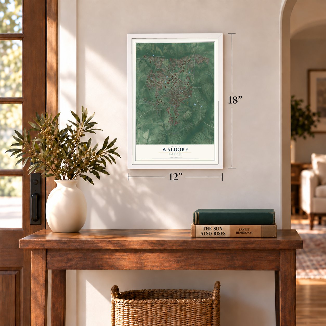
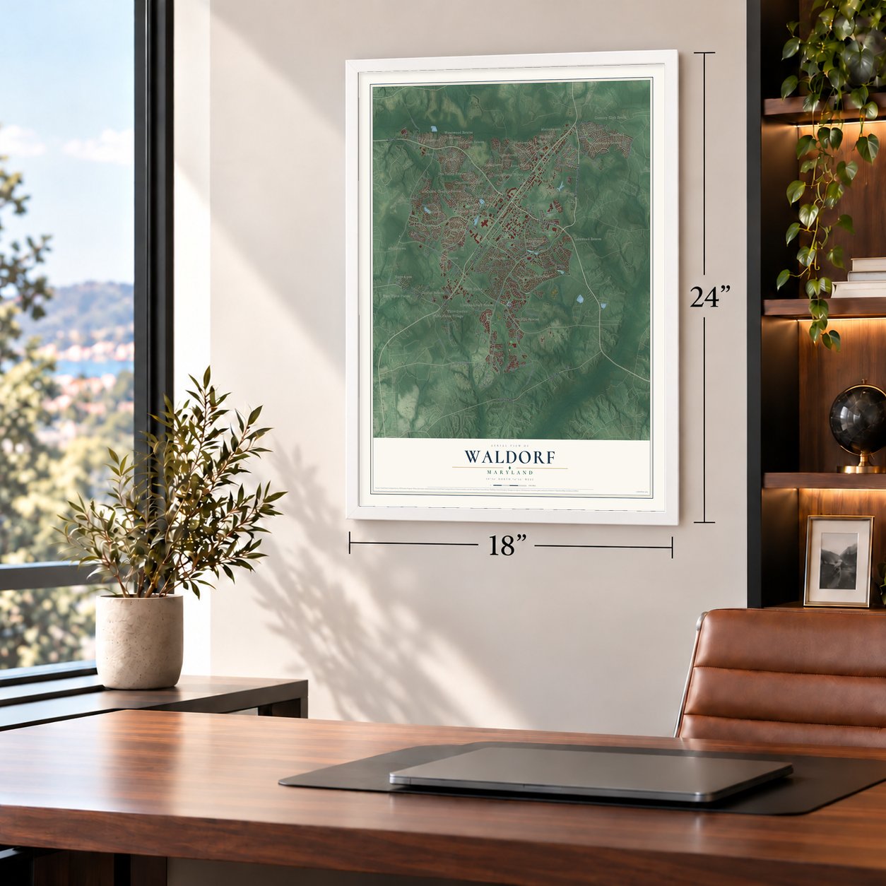
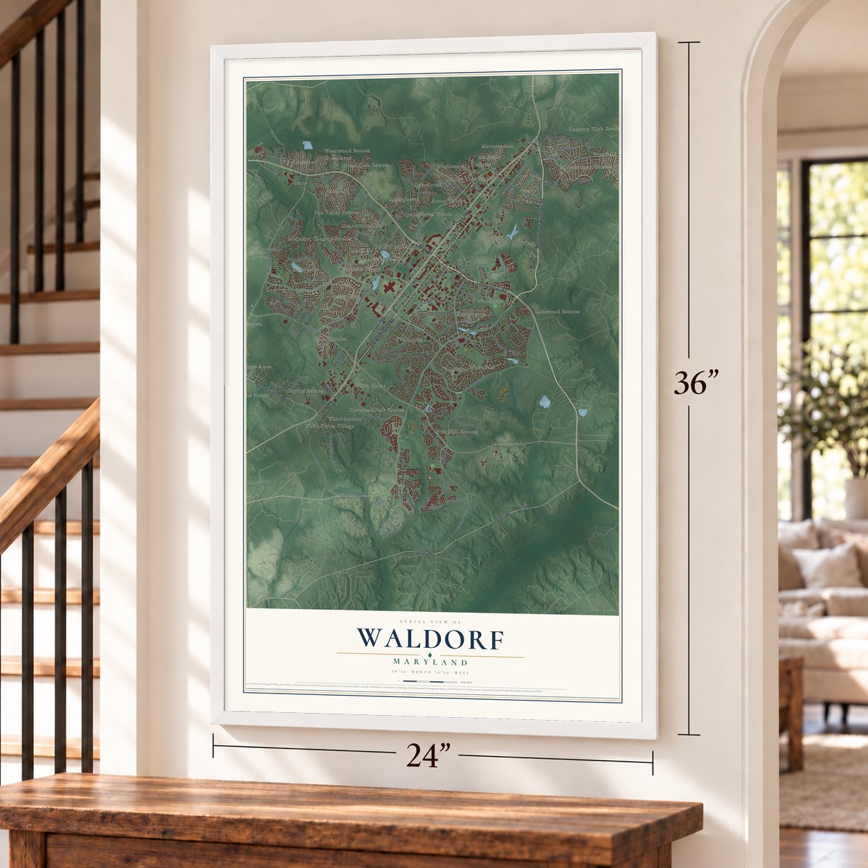
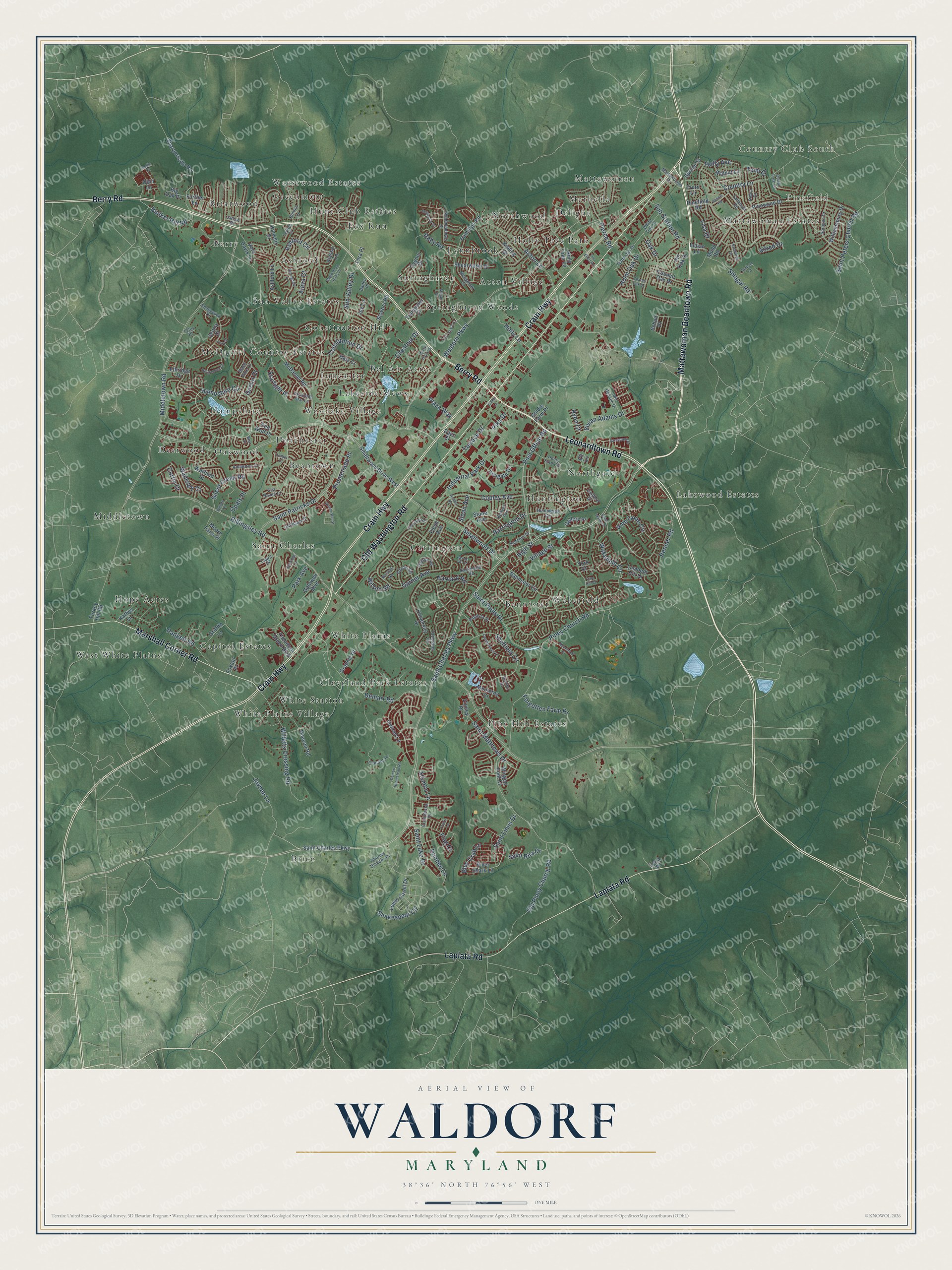
Waldorf, Maryland Map Art
Building by building, with labeled streets and shaded relief.
12" x 18" Archival Matte Print
A Map of Home. A Work of Art.
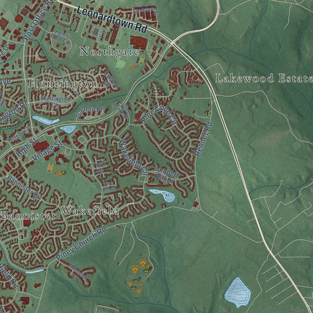
Explore Waldorf, Maryland from a whole new perspective. Created using aerial imagery and detailed geographic data, this map captures Waldorf building by building, with labeled streets, familiar landmarks, and shaded topographical relief that highlights the natural contours of the landscape.
Combining modern data with the timeless character of a vintage atlas, this map is just as interesting up close as it is beautiful on the wall. Whether you grew up in Waldorf, spent memorable years there, or call it home today, this unique map is a great way to celebrate a place that means something to you. Zoom in on the preview to look for your street, and then order a print to put your memories on the wall.
Three ways to hang it
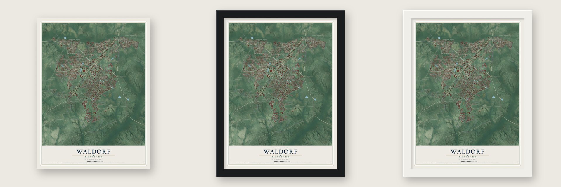
Unframed archival matte, a black wood frame or a white wood frame.
Up close
Geography Worth Displaying
This map was created using accurate cartographic data and authoritative geographic sources, including the U.S. Geological Survey and the Census Bureau. The map brings together terrain, waterways, roads, and building detail. The majority of the streets are labeled, houses are accurately depicted, and the topography is derived from government sources. Combining local data with carefully composed color and shading leads to this beautifully detailed Waldorf artwork for your wall.
Rather than simply showing street outlines, we’ve included as many of the street names as we could reasonably fit on the map while keeping their names legible. Zoom in on the high resolution preview to see exactly what’s on the map. We truly set out to create a statement piece for anyone who loves Waldorf. So whether it’s for you, or a gift for someone you love, we hope this map of Waldorf brings back fond memories.
Read the story behind this map of Waldorf, Maryland from 2026.

Find your street
Names on the Waldorf map
Every name below is printed on this map. Look for your street, your school, the park where you played, or the pond down the road.
Places and landmarks48
- Country Club South
- Pinefield
- Brice
- McDaniel Country Estates
- Pine Hill Estates
- Acton Village
- Middletown
- Huntington
- White Station
- Saint Charles
- Briarwood
- Marbella
Show all 48 places
- Bannister
- Bel Air Acres
- White Plains
- Deerwood
- Hunt Club Estates
- Lakewood Estates
- Hope Acres
- Beantown
- Holly Tree Park
- Lakeside Mews
- Carrington
- Springhaven
- Mattawoman Estates
- Hampshire
- Ashford
- Wakefield
- Cleveland Park Estates
- Mattawoman
- Constitution Hills
- Westlake Village
- Springhaven Woods
- Sun Valley Estates
- Lynnbrook
- West White Plains
- Capitol Estates
- Berry
- Weestwood Estates
- Dorchester
- Northgate
- Northwood
- Lancaster
- Greenmont
- Oakwood
- Fox Run
- White Plains Village
- Delight
Streets and roads207
- Leonardtown Road
- Crain Highway
- Berry Road
- Old Washington Road
- Mattawoman Beantown Road
- Laplata Road
- Marshall Corner Road
- Saint Charles Parkway
- Hampshire Circle
- Chestnut Drive
- Billingsley Road
- Western Parkway
- Middletown Road
- Saint Patricks Drive
- Piney Church Road
- Acton Lane
- Smallwood Drive
- Post Office Road
- Demarr Road
- Garner Avenue
- Saint Luke Drive
- Wakefield Circle
- Sheffield Circle
- Copley Avenue
- Jaybee Lane
- Industrial Park Drive
- Pine Cone Circle
- Old Piney Church Road
- Willetts Crossing Road
- Renner Road
Show all 207 streets
- Country Lane
- Constitution Drive
- Saint Pauls Drive
- Ashford Circle
- Shakespear Circle
- Shlagel Road
- Sun Valley Drive
- Saint Matthews Drive
- Forgotten Farm Place
- Pierce Road
- Harvard Road
- Saint Peters Church Road
- Sub Station Road
- Barrington Drive
- Holly Avenue
- Padgett Road
- Holm Oak Drive
- Vivian Adams Drive
- Saint Linus Drive
- Saint Rita Drive
- Raby Road
- Silent Creek Road
- Terrace Drive
- Bunker Hill Road
- Blue Crab Lane
- Lisa Drive
- Holly Lane
- Dundee Lane
- Atlantis Lane
- Promenade Place
- Oak Drive
- Plaza Way
- Temi Drive
- Wamsley Court
- Wilson Road
- High Street
- Ocelot Court
- Park Avenue
- Starlight Place
- Alava Court
- Alfred Drive
- Village Street
- Curtin Drive
- Opals Place
- Pika Drive
- Sloan Avenue
- Ryon Court
- Flag Court
- Smallwood Drive West
- Pinefield Road
- McDaniel Road
- University Drive
- Bannister Circle
- Pinewood Drive
- Hamilton Road
- Deacon Road
- Council Oak Drive
- Sharpersville Road
- Stone Avenue
- Alyssa Lane
- Kipling Drive
- Cygnet Drive
- Stavors Road
- Griffith Lane
- Holly Tree Lane
- Theodore Green Boulevard
- Warfield Street
- Williamsburg Drive
- Gallery Place
- Lewis Caroll Drive
- Pin Oak Drive
- Lambeth Hill Drive
- Irongate Drive
- Ashford Lane
- Shearwater Drive
- Inwood Lane
- Vera Davis Lane
- Foxtail Place
- Moore Farm Place
- River Shark Lane
- Walnut Lane
- Gateway Boulevard
- Monterey Court
- Spruce Street
- Graphic Drive
- Hale Court
- Winged Foot Court
- Trumpeter Court
- Elmley Place
- Kanegis Drive
- Ethridge Drive
- Goldie Farm Place
- Further Lane
- Kathys Lane
- Joy Lane
- Floyd Avenue
- Red Wolf Place
- Ell Lane
- Big Oak Place
- Truro Lane
- Turkey Hill Road
- Senna Court
- Tara Place
- Days Court
- Indian Lane
- Schult Place
- Ivy Lane
- Mudd Road
- Obin Lane
- Lena Place
- York Court
- Huntington Circle
- Sedgewick Drive
- Wildmeadows Street
- Henry Ford Circle
- Sprague Drive
- Claudes Place
- Tadcaster Circle
- Halm Oak Drive
- Cedar Tree Lane
- Amberton Court
- Augusta Street
- Adams Road
- Bonnie Lane
- Quillback Street
- Hamlin Road
- Falmouth Road
- Merganser Court
- Dartmouth Road
- White Oak Drive
- Mattawoman Drive
- John Hansen Drive
- Continental Drive
- Charles Dickens Drive
- Kenyon Avenue
- Guilford Drive
- October Place
- Esprit Place
- Black Pine Lane
- Debra Drive
- Shooting Star Lane
- Leyton Court
- Sea Raven Court
- Henley Court
- Janice Place
- Baden Place
- Lyles Place
- Moran Drive
- Marsh Hawk Drive
- Bergamont Court
- Demarr Homestead Road
- Castle Pines Lane
- Friars Lane
- Magdalene Acres Place
- Sandstone Street
- Saint Marks Drive
- Springdale Lane
- McIntosch Court
- Durham Court
- Marshall Road
- Sewickley Street
- Lady Alison Court
- Charter Oak Drive
- Winchester Street
- Sandwich Drive
- Sherman Road
- Acadia Road
- Dennis Road
- Vess Court
- Sunridge Lane
- Lue Ellen Road
- Willets Place
- Tattler Court
- Bear Court
- Gaelic Court
- Vine Hill Court
- Sidler Lane
Names are listed as they appear on the printed map. Zoom into the product photos to find them.
About Waldorf, Maryland
Waldorf is a community of 81,410 people in Charles County, in Southern Maryland, 23 miles south-southeast of Washington, D.C. The land was once part of the Piscataway Indian Nation, and Europeans and African Americans settled here in the 1600s. The railroad village began in 1872 on the B & P line and took the name Beantown Station, after the nearby community of Beantown.
In 1880, around the time its first post office opened, the Maryland General Assembly renamed it Waldorf. The new name honored William Waldorf Astor, whose great-grandfather John Jacob Astor came from Walldorf, Germany. For years Waldorf was a tobacco market village. Then Charles County made slot machines legal in 1949, and the town became a gambling destination in the 1950s. The boom ended in 1968, when gambling was banned again.
- Booth passed through BeantownIn 1865, while fleeing after he shot Abraham Lincoln, John Wilkes Booth told a sentry on the road that he was going home to Charles County near Beantown, and the guard let him go. Dr. Samuel A. Mudd set Booth's broken leg at his home in the Waldorf area, and Booth then continued his escape.
- St. Charles from 1970In 1970 the federal housing department backed the huge planned community of St. Charles, inside Waldorf, with a set of loans, and new neighborhoods followed. Fewer than 5,000 people lived in Waldorf in 1980. Its growth since then has made it the biggest center of homes and business in Southern Maryland.
- Blue Crabs since 2006The Southern Maryland Blue Crabs, founded in 2006, play in the Atlantic League of Professional Baseball. Their home is Regency Furniture Stadium, a 4,200-seat ballpark in Waldorf that also hosts soccer and concerts.
Keep exploring Maryland
Waldorf is one of 881 Maryland towns we've mapped. Every dot on the map is a print of its own.
The search covers every state, Maryland first.
Near Waldorf
Order 2 or more town maps and save 10%. Shown in the size and finish you picked above, so they hang as a set.
- Bensville 12" x 18" / Archival Matte Print $39.99
- La Plata 12" x 18" / Archival Matte Print $39.99
- Brandywine 12" x 18" / Archival Matte Print $39.99
More maps nearby: Malcolm, Bryantown, Cedarville, Accokeek and Pomfret.
The art of mapping a place
How This Map Was Made
Real places. Remarkable detail. Discover the layers that turn geographic data into a map of home.

The view from above
Aerial imagery reveals the character of the land: woodland, open fields, and the patterns of a place.

The shape of the land
Elevation data brings hills, valleys, and subtle changes in the landscape into view.

The details of home
Roads, waterways, and building footprints come together to make the map feel unmistakably local.

Geography becomes art
Considered color, shading, and typography bring the layers together in a map made for your wall.


Process illustrated with Mendon, Massachusetts. Aerial imagery: USDA NAIP. Terrain: USGS 3D Elevation Program. Map details and finished artwork: KNOWOL.
The Details
About This Print
Choose an archival matte print, or a black or white Ayous wood frame. The archival matte print is unframed.
Select your size and finish above to see the matching product image and price.
Materials & Craftsmanship
A contemporary map with the character of a classic atlas, printed on archival matte paper. Optional frames are made from Ayous wood.
Your printed map does not include the watermark shown in the full-map preview.
Shipping & Delivery
Free shipping within the United States. Every print is made to order in the USA.
Buying a gift? Add a note in your cart and we'll include it. We never put prices in the package.
Prints ship within 2 to 3 business days. Allow 7 to 10 days total from ordering for delivery. Timing may vary during holidays or periods of high order volume.
Read our shipping policy.
Returns and damaged prints
Each print is made to order. Change-of-mind refunds are not available after production.
If your print arrives damaged, misprinted or incorrect, contact support@knowol.com within 30 days of receiving it. Include your order number, photos and a description of the issue.
Read our full refund and replacement policy. For questions about your order, email support@knowol.com.